
List of mountains in Chile
Encyclopedia
Mountains by elevation
| Mountain | Metres | Feet |
|---|
Arica and Parinacota Region

- AcotangoAcotangoVolcán Acotango - is the central and highest of a group of stratovolcanoes straddling the border of Bolivia and Chile. The group is known as Nevados de Quimsachata and consists, apart of Acotango, of Volcán Humarata - to its north and Cerro Capurata - on its south.The group lies along a...
- Aritinca
- CapurataCerro CapurataCerro Capurata is a mountain in the Andes of Bolivia. It has a height of 5990 metres.-See also:*List of mountains in the Andes...
- GuallatiriGuallatiriGuallatiri is one of the most active volcanoes in northern Chile. It is just west of the border with Bolivia and at the southwestern end of the Nevados de Quimsachata. It is a symmetrical 6,071 m high ice-clad stratovolcano...
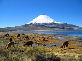
- Parinacota
- PomerapePomerapePomerape is a stratovolcano lying on the border of Chile and Bolivia . It is part of the Nevados de Payachata complex of volcanoes together with Parinacota Volcano to the south. It is of Pleistocene age.Climbing the volcano is alpine AD grade, sometimes on 50+ degree snow/rubble slope...
- TaapacaTaapacaTaapaca, is part of the Nevados de Putre volcanic complex. It is a complex volcano located in Chile's XV region of Tarapaca, and towers over the picturesque town of Putre....
- TacoraTacoraTacora is a stratovolcano located in Arica y Parinacota Region of Chile. It is the northernmost volcano of Chile....
Antofagasta RegionAntofagasta RegionThe II Antofagasta Region is one of Chile's fifteen first-order administrative divisions. It comprises three provinces, Antofagasta, El Loa and Tocopilla...
- AcamarachiAcamarachiAcamarachi, also known as Pili, is a stratovolcano located northeast of the volcanoes Aguas Calientes and Lascar, and southwest of the sector Salar de Pujsa of Los Flamencos National Reserve, in the Antofagasta Region of Chile. The volcano lies on a high plateau called Puna de Atacama.It has a...
- Aguas CalientesAguas Calientes (volcano)Aguas Calientes Volcano or Cerro Aguas Calientes, also called Simbad, is a cone-shaped stratovolcano located east of the Lascar volcano and directly north of Laguna Lejía, in Chile's II Region...
- AucanquilchaAucanquilchaAucanquilcha is a massive stratovolcano located in Antofagasta Region of northern Chile, just west of the border with Bolivia. It comprises a number of overlapping cones along a 10 km long ridge that forms the summit. There is weak, episodic fumarolic activity and voluminous sulfur...
- AzufreCerro del AzufreCerro del Azufre is a stratovolcano located in El Loa Province, Antofagasta Region, Chile. It is part of a chain of volcanoes that separate Upper Loa River basin from Salar de Ascotán basin and is flanked to the west by a dacitic lava dome called Chanka or Pabellón...
- CaichinqueCaichinqueCaichinque is a volcanic complex lying between Salar de Talar and Salar de Capur, in the high Andean plateau of the Antofagasta Region, in Chile...
- ChiliquesChiliquesChiliques is a stratovolcano located in the Antofagasta Region of Chile, immediately north of Cerro Miscanti. Laguna Lejía lies to the north of the volcano.The volcano, which has been dormant for at least 10,000 years, is now showing signs of life...
- Colachi
- Colorado
- Escorial
- GuayaquesGuayaquesThe 10-km-long Cerros de Guayaques chain of N-S-trending rhyodacitic lava domes runs across the Chile-Bolivia border about 10 km. east of the Cerro Toco - Purico Complex....
- IncahuasiCerros de IncahuasiCerros de Incahuasi is a mountain with several summits located in the Antofagasta Region of Chile, near Sico Pass....
- JuriquesJuriquesJuriques is a stratovolcano on the border between Bolivia and Chile. It is located immediately southeast of Licancabur volcano and has a summit crater 1.5 km in its longest diameter. Laguna Verde lies at the foot of this volcano....
- LascarLascar Volcano-Geographical setting:Lascar is located in the altiplano of the Antofagasta Region of northern Chile, east of the Salar de Atacama, immediately west of the Aguas Calientes volcano, and to the northeast of Laguna Lejía...
- LastarriaLastarriaLastarria, also known as Azufre, is a stratovolcano along the border of Argentina and Chile....
- LicancaburLicancaburLicancabur is a highly symmetrical stratovolcano on the southernmost part of the border between Chile and Bolivia. It is located just southwest of Laguna Verde in Bolivia. The volcano dominates the landscape of the Salar de Atacama area...
- LinzorLinzorVolcán Linzor is a stratovolcano on the border between Bolivia and Chile. In its vicinity lie Laguna Colorada and Cerro del León....
- LlullaillacoLlullaillacoLlullaillaco is a stratovolcano at the border of Argentina and Chile. It lies in the Puna de Atacama, a region of very high volcanic peaks on a high plateau within the Atacama Desert, one of the driest places in the world...
- MinchinchaCerro MinchinchaCerro Minchincha is a stratovolcano on the border of Bolivia and Chile. It is part of an east-west trending ridge of stratovolcanoes. To its east lies Olca. The only historical activity from the complex was a flank eruption from 1865-1867....
- MiñiquesMiñiquesMiñiques is a massive volcanic complex containing a large number of craters, lava domes and flows, located in the Antofagasta Region of Chile. Located south of Volcán Chiliques and west of Cordón Puntas Negras, it is part of a frequently visited attraction conformed by the high plain lagoons...
- Miño
- MiscantiCerro MiscantiCerro Miscanti is a mountain located in the Antofagasta Region of Chile, immediately south of Chiliques and north of Miñiques. It towers over Laguna Miscanti.-See also:* Miñiques* Chiliques* Laguna Miscanti* Cordón Puntas Negras...
- OlcaOlcaOlca is a stratovolcano on the border of Chile and Bolivia. It lies in the middle of a 15 km long ridge composed of several stratovolcanos. Cerro Minchincha lies to the west and Paruma to the east. It is also close to the pre-Holocene Cerro Paruma. It is andesitic and dacitic in composition,...
- OllagüeOllagüeOllagüe is a massive andesite stratovolcano in the Andes on the border between Bolivia and Chile. It is located southeast of the village that shares its name....
- PalpanaPalpanaPalpana is a mountain in the Andes of Chile. It has a height of 6023 metres....
- ParanalCerro ParanalCerro Paranal , also known as Paranal Mountain is a mountain in the Atacama desert of northern Chile that is home to the Paranal Observatory. It is famous for hosting the Very Large Telescope and the VLT Survey Telescope. It is located 120 km west of Antofagasta and 80 km north of Taltal,...
- ParumaParumaParuma is a stratovolcano that lies on the border of Bolivia and Chile. It is part of a ridge that contains several stratovolcanos. Paruma lies at the eastern end of the ridge, with Olca to its west. The older volcano Cerro Paruma lies to east of Paruma. Paruma has clearly been active during the...
- PularPular (volcano)Pular is a massive stratovolcano located in the Antofagasta Region of northern Chile, about 15 km west of the border with Argentina, which in this area is a straight line between the summits of Socompa volcano and Cerro del Rincón...
- Puntas NegrasCordón de Puntas NegrasCordón Puntas Negras is a volcanic chain located east of the Salar de Atacama in Chile's II Region, which runs from the Chiliques volcano on the north to volcán Puntas Negras almost to the SE. The Puntas Negras Volcano volcano forms the common endpoint of two chains of volcanoes in a V-shaped...
- PutanaPutanaIn Hindu mythology, Putana is a Rakshasi , who is killed by the infant-god Krishna. Putana is also considered as a foster-mother of Krishna as she breast-fed him, though it was with the motive of killing Krishna by poisoned milk...
- Quimal
- SairecaburSairecaburThe Sairécabur volcanic group is a volcanic chain directly south of the Putana Volcano, on the border between Bolivia and Chile. It contains at least 10 postglacial centers, the highest of which is Cerro Sairécabur at...
- SalinSalinSalin is a town of Minbu District in the Magway Division of Myanmar....
- San Pablo
- San PedroSan Pedro (Chile volcano)San Pedro is one of the tallest active volcanoes in the world. It is located on the edge of the Atacama Desert, in Chile. San Pablo volcano is its neighbor to the east and from which is connected by a high saddle. Cerro Paniri volcano lies on the opposite side of the San Pedro River Valley. When...
- SocompaSocompaSocompa is a large complex stratovolcano at the border of Argentina and Chile. It is best known for its large debris avalanche deposit, which is widely accepted as the best-preserved example of this type of deposit in the world, and also notable as the home of the world's most elevated known...
- TocoCerro TocoCerro Toco is a stratovolcano located in the eastern part of the Atacama desert in Chile's II Region , approximately south of the border between Bolivia and Chile and SE of the Juriques and Licancabur volcanoes...
- Tocorpuri
- Zapaleri
Atacama RegionAtacama RegionThe Atacama Region is one of Chile's 15 first order administrative divisions. It comprises three provinces, Chañaral, Copiapó and Huasco. It is bordered to the north by Antofagasta, to the south by Coquimbo, to east with Provinces of Catamarca, La Rioja and San Juan of Argentina, and to west with...
- Barrancas BlancasBarrancas BlancasBarrancas Blancas is a mountain in the Andes of Chile. It has a height of 6119 metres.-See also:*List of mountains in the Andes...
- AzufreCordón del AzufreCordón del Azufre is a small, inactive complex volcano located on the Central Andes, at the border of Argentina and Chile.-External links:* - Volcanology at the University of North Dakota...
- Bayo
- ColoradosCerro ColoradosCerro Colorados is a mountain in the Andes about north of Santiago in Chile. It has a height of .-See also:*List of mountains in the Andes...
- CopiapóCopiapó (volcano)Copiapó, also known as Azufre, is a stratovolcano located in the Atacama Region of Chile. The volcano separates the two portions in which Nevado Tres Cruces National Park is divided. In its vicinity lies Ojos del Salado....
- El MuertoCerro El MuertoCerro el Muerto is a mountain peak of South America and is part of the Andes mountain range. It is also known as the 16th of the largest mountain peaks in the Argentine-Chilean border at...
- El Ermitaño
- El Fraile
- El Toro
- Falso Azufre
- IncahuasiIncahuasiIncahuasi or Nevado de Incahuasi is a mountain between the Argentine province of Catamarca, and the Atacama Region of Chile. Located at approximate coordinates , it has a height of 6,621m....
- Mulas Muertas
- Ojos del SaladoOjos del SaladoNevado Ojos del Salado is a massive stratovolcano in the Andes on the Argentina-Chile border and the highest volcano in the world at . It is also the second highest mountain in the Western Hemisphere and Southern Hemisphere and the highest in Chile...
- Peña Blanca
- San Francisco
- Sierra Nevada de Lagunas BravasSierra Nevada de Lagunas BravasSierra Nevada, also known as Sierra Nevada de Lagunas Bravas, is a volcanic complex which lies in both Chile and Argentina. Some of the complex is of Holocene age, but there is also an older Pleistocene volcanism evident. The older material is to the east in Argentina. The complex lies in one of...
- SoloCerro SoloCerro Solo is a large stratovolcano on the border between Argentina and Chile, west of Ojos del Salado. It consists of nine eruptive centers and is covered in light-colored rhyodacite pyroclastic flow deposits....
- Tres CrucesNevado Tres CrucesNevado Tres Cruces is a massif of volcanic origin in the Andes Mountains. It has two main summits, Tres Cruces Sur at 6,749 m and Tres Cruces Central at 6,629 m and a third more minor summit, Tres Cruces Norte 6030m. The former marks the border between Argentina and Chile...
- Tres Quebradas
- Vicuñas
Valparaíso RegionValparaíso RegionThe V Valparaíso Region is one of Chile's 15 first order administrative divisions.Valparaíso Region, 2006 With the country's third highest population of 1,539,852 million in 2002 and third smallest area of , the region is Chile's second most densely populated after the Santiago Metropolitan Region...
- Alto de los Leones
- Juncal
Santiago Metropolitan RegionSantiago Metropolitan RegionSantiago Metropolitan Region or simply Metropolitan Region is one of Chile's 15 first order administrative divisions. It is the country's only landlocked administrative region and contains the nation's capital, Santiago...
- ArenasCerro ArenasCerro Arenas is a mountain in the Andes of Santiago Metropolitan Region, Chile. It is located west of San José volcano and east of Cerro El Morado. The latter mountain lies on the opposite side of the valley of the Estero Morado, a headwater stream of the Volcán River....
- El MoradoCerro El MoradoCerro El Morado is a mountain in the Andes of Chile. It has a height of ....
- El PlomoCerro El PlomoCerro El Plomo is a mountain located in the Andes near Santiago, Chile. It is the largest peak visible from Santiago on clear days. The adequate season to climb this mountain is between November and March. In spring, soil conditions have abundant snow on the approach...
- MarmolejoMarmolejoVolcán Marmolejo is a high Pleistocene stratovolcano in the Andes on the border between Argentina and Chile. It is located NNE of the active San José volcano, and has the distinction of being the southernmost -plus peak in the world.- See also :...
- Plomo
- Risopatrón
- San JoséSan José (volcano)San José Volcano is the stratovolcano that gives its name to a massive volcanic group, at about from Santiago de Chile at the end of the Cajón de Maipo on the Chile-Argentina border...
- TupungatitoTupungatitoVolcán Tupungatito is the northernmost historically active stratovolcano of the southern Andes. It lies on the border between Argentina and Chile, about east of Santiago, Chile, and immediately southwest of the massive Cerro Tupungato stratovolcano. Its name is a diminutive homonym, just as in...
- TupungatoTupungatoTupungato, one of the highest mountains in South America, is a massive stratovolcano dating to Pleistocene times. It lies on the border between the Chilean Metropolitan Region and the , near a major international highway about 80 km east of Santiago, Chile. It is located about south of Monte...
O'Higgins RegionO'Higgins RegionThe VI O'Higgins Region is one of Chile's 15 first order administrative divisions. It is subdivided into three provinces. It is named in honour of Bernardo O'Higgins Riquelme, one of Chile's founding fathers....
- Alto de los Arrieros
- PalomoPalomoPalomo is a Chilean stratovolcano located in the O'Higgins Region, west of Caldera del Atuel. The volcano shows evidence of glacial dissection....
- TinguiriricaTinguiririca (volcano)Tinguiririca Volcano is a massive and active stratovolcano located in Chile's 6th or O'Higgins Region and near the Argentinian border. Constant fumarolic activity occurs within and on the NW wall of its summit crater and hot springs and fumaroles can also be seen on the western flanks, as...
Maule RegionMaule RegionThe VII Maule Region is one of Chile's 15 first order administrative divisions. Its capital is Talca. The region takes its name from the Maule River which, running westward from the Andes, bisects the region and spans a basin of about 20,600 km2...
- AzulCerro Azul (Chile volcano)Cerro Azul , sometimes referred to as Quizapu, is an active stratovolcano in the Maule Region of central Chile, immediately south of Descabezado Grande. Part of the South Volcanic Zone of the Andes, its summit is above sea level, and is capped by a summit crater that is wide and opens to the north...
- Descabezado Chico
- Descabezado GrandeDescabezado GrandeDescabezado Grande is a stratovolcano located in the Maule Region of central Chile. It is capped by a ice-filled caldera and named for its flat-topped form, as descabezado means "headless" in Spanish...
- LongavíNevado de LongavíNevado de Longaví is a stratovolcano in the Andes of central Chile. The 3,242 m perennially snowcapped peak is a landmark of Linares Province and the Maule Region, visible from practically every point in the Central Valley of the province and the neighbouring Province of Cauquenes.Treking in...
- Planchón-PeteroaPlanchón-PeteroaPlanchón-Peteroa is a complex volcano extending in a north-south direction along the border between Argentina and Chile. It consists of volcanoes of various ages with several overlapping calderas...
Bío-Bío RegionBío-Bío RegionThe VIII Biobío Region , one of the fifteen first-order administrative divisions in Chile, comprises four provinces: Arauco, Biobio, Concepción, and Ñuble.The capital of the Region is Concepción...
- AntucoAntuco (volcano)Antuco Volcano is a stratovolcano located in the Bío-Bío Region of Chile, near Sierra Velluda and on the shore of Laguna del Laja.- In literature :* The Voyage of the Beagle by Charles Darwin* Les Enfants du capitaine Grant by Jules Verne...
- CallaquiCallaquiCallaqui is a stratovolcano located in the Bío-Bío Region of Chile. It is a large ice-capped, basaltic andesite volcano which is elongated in the northeast-southwest direction, due to its construction along an 11 km long fissure. Numerous cinder cones and lava flows have erupted from...
- Nevados de ChillánNevados de ChillánNevados de Chillán is a group of stratovolcanoes located in the Andes of the Bío-Bío Region, Chile, and is one of the most active volcanoes in the region. It consists of three overlapping peaks, Cerro Blanco at the northwest and Volcán Viejo at the southeast, with Volcán Nuevo in the middle...
- CopahueCopahueCopahue is a stratovolcano on the border between Argentina and Chile. There are nine volcanic craters along a line, and the eastern summit crater contains a briny, acidic 300 m wide crater lake...
- Sierra VelludaSierra VelludaSierra Velluda is a massive Pleistocene stratovolcano located immediately southwest of the Antuco Volcano, in the Bío-Bío Region of Chile. The heavily glaciated mountain has two main summits and is the tallest mountain in Laguna del Laja National Park....
Araucanía RegionAraucanía RegionThe IX Araucanía Region is one of Chile's 15 first order administrative divisions and comprises two provinces: Malleco in the north and Cautín in the south....
- LanínLanínLanín is an ice-clad, cone-shaped stratovolcano on the border of Argentina and Chile. It forms part of two national parks: Lanín in Argentina and Villarrica in Chile. It is a symbol of the Argentine province of Neuquén, being part of its flag and its anthem. Although the date of its last eruption...
- highest mountain in Araucanía Region - LlaimaLlaimaLlaima Volcano is one of the largest and most active volcanoes in Chile. It is situated 82 km northeast of Temuco and 663 km southeast of Santiago, within the borders of Conguillío National Park.-Geography:...
- LonquimayLonquimay (volcano)Lonquimay Volcano is a stratovolcano of late-Pleistocene to dominantly Holocene age, with the shape of a truncated cone. The cone is largely andesitic, though basaltic and dacitic rocks are present. It is located in the Araucanía Region of Chile, immediately SE of Tolhuaca volcano. Sierra Nevada...
- QuetrupillánQuetrupillánQuetrupillán Volcano is a stratovolcano located in the Araucanía Region of Chile. It is situated between Villarrica and Lanín volcanoes, within Villarrica National Park. Geologically, Quetrupillán is located in a tectonic basement block between the main traces of Liquiñe-Ofqui Fault and...
- Sierra NevadaSierra Nevada (stratovolcano)Sierra Nevada is a stratovolcano located in the Araucanía Region of Chile, near the Llaima volcano. Its last certain eruptions were in the Pleistocene period, but its activity may extend into the Holocene. Its primary lavas are andesitic and basaltic flows, although it has also produced pyroclastic...
- SollipulliSollipullithumb|right|Nevados de Sollipulli as seen from [[Villarrica |Villarrica Volcano]]Sollipulli is an ice-filled volcanic caldera, which lies about 12 kilometres south of the small town of Melipeuco in the Araucanía Region, Chile...
- TolhuacaTolhuaca (volcano)Tolhuaca Volcano is a stratovolcano located in the northern part of the Araucanía Region of Chile. The volcano has been shaped by glacial erosion, which contrasts with the relatively smooth slopes of its neighbor Lonquimay, due to the younger age of this latter volcano.The volcano dominates the...
- VillarricaVillarrica (volcano)Villarrica is one of Chile's most active volcanoes, rising above the lake and town of the same name. The volcano is also known as Rucapillán, a Mapuche word meaning "House of the Pillán". It is the westernmost of three large stratovolcanoes that trend perpendicular to the Andean chain along the...
Los Ríos RegionLos Ríos RegionThe XIV Los Ríos Region is one of Chile's 15 first order administrative divisions. Its capital is Valdivia. Pop. 356,396 . It began to operate as region on October 2, 2007. It was created by subdividing the Los Lagos Region in southern Chile...
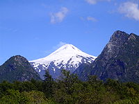
- VillarricaVillarrica (volcano)Villarrica is one of Chile's most active volcanoes, rising above the lake and town of the same name. The volcano is also known as Rucapillán, a Mapuche word meaning "House of the Pillán". It is the westernmost of three large stratovolcanoes that trend perpendicular to the Andean chain along the...
- highest mountain in Los Ríos Region - Cacho del Toro
- CarránCarranCarran is a village in County Clare, Ireland, bounded on the northwest by County Galway and on the south by Kilinaboy, Slieve Carron, one of the highest points in the Burren lies just north of the village,the area is renowned for its walking trails and spectacular views over the Burren...
- Caulle
- MaltusadoCerro MaltusadoCerro Maltusado is the highest peak of La Peineta arête in the Andes of Los Ríos Region, Chile. The peak has an arpoximate prominence of about 1425 meters from its base at Riñihue Lake being close to be a ultra prominent peak....
- Lipinza
- Mocho-ChoshuencoMocho-ChoshuencoMocho-Choshuenco is a glacier covered compound stratovolcano in the Andes of Los Ríos Region, Chile. It is made of the twin volcanoes Choshuenco in the northwest and the Mocho in the southeast...
- Nevado Las AgujasNevado Las AgujasNevado Las Agujas is a pyramidal peak in the Andes of Futrono close to the border of Chile and Argentina. Together with Cerro Chihuío it forms the granitic mountain massif of Nevados Las Agujas which geologically belong to the Northern Patagonian Batholith....
- OncolCerro OncolCerro Oncol is mountain located in the north of the Valdivian Coast Range, Chile. With its 715 m it is the highest peak of the Chilean Coast Range between Nahuelbuta Range and Corral Bay. Cerro Oncol and its surroundings are located inside Oncol Park....
- Paillahuinte
- Puyehue
- Trafa
- TralcánTralcanTralcán is a triangular shaped mount near Riñihue Lake, Chile. It is located south of the outflow dividing western Riñihue in two arms. Despite been sacred for the huilliches for centuries, the mount became famous when several landslides near Tralcan dammed the Riñihue Lake, after the Great...
Los Lagos RegionLos Lagos RegionLos Lagos Region is one of Chile's 15 regions, which are first order administrative divisions, and comprises four provinces: Chiloé, Llanquihue, Osorno and Palena. The region contains the country's second largest island, Chiloé, and the second largest lake, Llanquihue.Its capital is Puerto Montt;...
- AntillancaAntillanca GroupAntillanca Group is a volcanic group of scoria cones, maars and small stratovolcanoes. Casablanca stratovolcano is the tallest volcano of the group, which shelters the Antillanca ski resort on its west flank. Aguas Calientes and Puyehue Hot springs also form part of this volcanic group...
- Calbuco
- CorcovadoCorcovado (volcano)Corcovado Volcano is a stratovolcano located about 25 km south of the mouth of Yelcho River, in the Palena Province, Los Lagos Region, Chile. The glacially eroded volcano is flanked by Holocene cinder cones. The most distinctive feature of this volcano is its stepped top, similar to that of...
- HornopirénHornopirén (volcano)Hornopirén is a stratovolcano located in the Andes, in Los Lagos Region of Chile, south of Yate Volcano and east of Apagado or Hualiaque pyroclastic cone. Hornopirén lies on the major regional Liquine-Ofqui Fault. The volcano is said to have erupted in 1835, although no details are known...
- MichinmahuidaMichinmahuidaMichinmahuida is a glaciated stratovolcano located in Los Lagos Region of Chile. It lies about 15 km east of Chaitén volcano, and was extensively covered in ash during the 2008 eruption of Chaitén...
- OsornoVolcán OsornoOsorno Volcano is a tall conical stratovolcano lying between Osorno Province and Llanquihue Province, in Los Lagos Region of Chile. It stands on the southeastern shore of Llanquihue Lake, and also towers over Todos los Santos Lake...
- PuntiagudoPuntiagudo-Cordón CenizosPuntiagudo-Cordón Cenizos is a snow-capped volcanic chain located in the Andes, in Los Lagos Region of Chile, near Volcán Osorno. It lies between Rupanco Lake and Todos los Santos Lake...
- TronadorTronadorTronador is an extinct stratovolcano in the southern Andes, located along the border between Argentina and Chile near the city of Bariloche. The mountain was named Tronador by locals in reference to the sound of falling seracs...
- highest mountain in Los Lagos Region - YantelesYantelesYanteles is an isolated stratovolcano composed of five glacier-capped peaks along an 8 km-long NE-trending ridge. It is located approximately south of the Corcovado volcano in the Chilean X Region within the Corcovado National Park....
- YateYate (volcano)Yate Volcano is a large, glaciated stratovolcano located in the southern Andes, in the Los Lagos Region of Chile, south of the Reloncaví Estuary...
Aisén Region
- ArenalesCerro ArenalesCerro Arenales is a heavily ice-covered stratovolcano located in the Aisén Region of Chile, within Laguna San Rafael National Park. It towers over the southern part of the Northern Patagonian Ice Field....
- Barros Arana
- CastilloCerro CastilloCerro Castillo is a jagged rocky peak located in the Aisén Region of Chile, within the Cerro Castillo National Reserve. Castillo means castle in Spanish, and the steep basalt walls of the mountain indeed make it look like one. On its sides are a few small glaciers and lakes fed by...
- HudsonMount HudsonMount Hudson is a stratovolcano in southern Chile, and the site of one of the largest eruptions in the twentieth century. The mountain itself is covered by a glacier. There is a caldera at the summit from an ancient eruption; modern volcanic activity comes from inside the caldera...
- LautaroLautaro (volcano)Lautaro Volcano is an active ice-covered stratovolcano located in Chilean Patagonia, in the northern part of the Southern Patagonian Ice Field. Its summit rises more than above the average surface of the ice cap plateau. It is the tallest mountain in Bernardo O'Higgins National Park and in its...
- MacáCerro MacáCerro Macá is a stratovolcano located to the north of the Aisén Fjord and to the east of the Moraleda Channel, in the Aisén Region of Chile. This glacier-covered volcano lies along the regional Liquiñe-Ofqui Fault Zone....
- MelimoyuMelimoyuMelimoyu is a stratovolcano with an 8-km-wide, largely buried caldera located about 40 km NW of the town of Puerto Puyuhuapi, in the Aisén Region of Chile. It lies near the northern entrance of the Moraleda Channel.- References :*...
- MentolatMentolatMentolat is an ice-filled wide caldera in the central portion of Magdalena Island, Aisén Province, Chilean Patagonia. It forms part of the Isla Magdalena National Park. Little is known of the eruptive history of Mentolat, but it is thought to be young, with a possible eruption in the early 1700's...
- Pared NorteCerro Pared NorteCerro Pared Norte is a mountain located in the Aisén Region of Chile. It lies on the Northern Patagonian Ice Field, at the center of a mountain ridge with steep slopes and sheer cliffs, at whose southern and northern tips lie, respectively, Cerro Pared Sur and an unnamed summit. A glacier named...
- PuyuhuapiPuyuhuapi (volcanic group)Puyuhuapi Volcanic Group is a volcanic group of cinder cones located at the head of Puyuhuapi Channel, in the Aisén Region of Chile....
- San LorenzoMonte San LorenzoMonte San Lorenzo, also known as Monte Cochrane, is a mountain on the border between Argentina and Chile in Patagonia, reaching a height of . The Chilean name of Cochrane comes from the nearby town of Cochrane where climbers often approach the mountain...
- San ValentínMonte San ValentinMonte San Valentin, also known as Monte San Clemente, is the highest mountain in Chilean Patagonia and the highest mountain south of 40°S outside Antarctica. It stands at the north end of the North Patagonian Icefield....
- highest mountain in Aysén Region - SteffenCerro SteffenCerro Steffen is one of the highest mountains in the Southern Patagonian Ice Field. It lies on the northeastern edge of the just mentioned icefield, west of O'Higgins Lake....
Magallanes and Antártica Chilena Region
- AguileraAguilera (volcano)Aguilera is a stratovolcano in southern Chile, which rises above the edge of the Southern Patagonian Ice Field.It is located west of Lake Argentino and northeast of Peel Fjord in the southern Andes....
- BalmacedaMonte BalmacedaMonte Balmaceda is a heavily glaciated mountain located in the Magallanes Region of Chile. It stands at the head of Última Esperanza Sound, in the south portion of Bernardo O'Higgins National Park and near the mouth of the Serrano River...
- BurneyMonte BurneyMonte Burney is an ice-capped stratovolcano located 200 km northwest of the city of Punta Arenas and south of the Cordillera Sarmiento, on the Peninsula Muñoz Gamero, in the Chilean Patagonia.The mountain was named Mount Burney in honor of James Burney....
- Castillo DynevorCerro Castillo DynevorCerro Castillo Dynevor, also known as Castillo Dynevor is located on the Northwest coast of Skyring Sound, in Magallanes Region, Chile. It's named after its resemblance with Dynevor Castle in Wales, which was noticed by British explorers in 1830....
- DarwinMount Darwin (Andes)Mount Darwin, the highest peak in Tierra del Fuego at forms part of the Cordillera of the Andes, South America, just to the north of the Beagle Channel. It is formed of crystalline schists and has massive glaciers down its steep southern slopes....
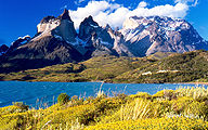
- Fitz RoyCerro ChalténMonte Fitz Roy is a mountain located near El Chaltén village, in the Southern Patagonian Ice Field in Patagonia, on the border between Argentina and Chile...
- highest mountain in Magallanes Region - SarmientoMonte SarmientoMonte Sarmiento is a pyramidal peak with a glaciated saddle-shaped summit located within Alberto de Agostini National Park, in the Chilean portion of Tierra del Fuego. It rises abruptly from the east shore of the Magdalena Channel and marks the western border of the Cordillera Darwin...
- TarnMount TarnMount Tarn is a small mountain located on the southernmost part of the Strait of Magellan, in Brunswick Peninsula, about 70 km south of Punta Arenas, Chile...
- TorreCerro TorreCerro Torre is one of the mountains of the Southern Patagonian Ice Field in South America. It is located in a region which is disputed between Argentina and Chile, west of Cerro Chalten . The peak is the highest in a four mountain chain: the other peaks are Torre Egger , Punta Herron, and Cerro...