

Spratly Islands dispute
Encyclopedia
The Spratly Islands dispute is a territorial dispute
over the ownership of the Spratly Islands
, a group of islands located in the South China Sea
. States staking claims to various islands are: the People's Republic of China
, the Republic of China
(Taiwan), Malaysia, the Philippines
, Vietnam
, and Brunei
. All except Brunei occupy some of the islands.
The Spratly Islands are important for a number of reasons: the Spratly area holds significant reserves of oil
and natural gas
, it is a productive area for world fishing and commercial shipping, and coastal countries would get an extended continental shelf. But some countries, like the People's Republic of China, the Republic of China, and Vietnam make claims based on historical sovereignty over the islands.
, placing it as the fourth largest reserve bed in the world. These large reserves assisted in intensifying the situation and propelled the territorial claims of the neighboring countries.
In 1968, the Philippines started to take their claims more seriously and stationed troops on three islands which had been claimed by the adventurer Tomas Cloma
as part of Freedomland. In 1973 Vietnamese troops were stationed on five islands.
On 11 March 1976, the first major Philippine oil discovery occurred off the coast of Palawan
, within the Spratly Islands territory, and these oil fields now account for fifteen percent of all petroleum consumed in the Philippines. In 1992, the PRC and Vietnam granted oil exploration contracts to U.S. oil companies that covered overlapping areas in the Spratlys. In May 1992, the China National Offshore Oil Corporation (CNOOC) and Crestone Energy (a U.S. company based in Denver, Colorado
) signed a cooperation contract for the joint exploration of the Wan'an Bei-21 block, a 25,155 km² section of the southwestern South China Sea that includes Spratly Island areas. Part of the Crestone's contract covered Vietnam's blocks 133 and 134, where PetroVietnam, PetroStar Energy(USA) and ConocoPhillips Vietnam Exploration & Production, a unit of ConocoPhillips
, agreed to evaluate prospects in April 1992. This led to a confrontation between China and Vietnam, with each demanding that the other cancel its contract.
(EEZ) and the media regularly report the arrest of Chinese fishermen. In 1984, Brunei established an exclusive fishing zone encompassing Louisa Reef in the southeastern Spratly Islands.
and five times more than through the Panama Canal
; twenty five percent of the world's crude oil passes through the South China Sea.
On May 23, 2011, Philippine President Benigno Aquino III
warned the Chinese defense minister of a possible arms race
in the region if tensions worsened over disputes in the South China Sea. Aquino said he told visiting Chinese Defense Minister Liang Guanglie
in their meeting that such an arms race could result if there were more encounters in the disputed and potentially oil-rich Spratly islands. The Philippines warned China that it might increase its military capabilities.
(UNCLOS) procedure for countries with coastlines to submit claims for their continental shelf to be extended beyond 200 nautical miles of their shores brought the spotlight back to the South China Sea and Spratly Islands in May 2009. Two such submissions were made - one by Vietnam for a claim over the northern portion of the sea which included the Paracel Islands
, and another jointly by Vietnam and Malaysia for a joint claim over a "defined area" in the middle of the sea between the two countries which included part of the Spratly Islands. Brunei, a potential claimant, has not submitted such a claim but had provided preliminary information to the United Nations notifying it of its intention to claim a continental shelf beyond 200 nautical miles from its shores.
China immediately issued protests over the two submissions and called on the United Nations not to consider them. It also issued a stern warning to countries not to claim the islands which it said were its sovereign territory.
In the early 21st century, the situation is improving. China recently held talks with ASEAN countries aimed at realizing a proposal for a free trade area between the ten countries involved. China and ASEAN have also been engaged in talks to create a code of conduct aimed at easing tensions in the disputed islands. On 5 March 2002, an agreement was reached, setting forth the desire of the claimant nations to resolve the problem of sovereignty "without further use of force". In November 2002, a Declaration on the Conduct of Parties in the South China Sea was signed, easing tensions but falling short of a legally binding code of conduct.
In the interim, the parties pledged to carry out confidence building measures, such as by holding dialogues and exchange of views as appropriate between their defense and military officials; ensuring just and humane treatment of all persons who are in danger or distress; notifying on a voluntary basis other Parties concerned of any impending joint/combined military exercise; and exchanging, on a voluntary basis, relevant information.
The Parties may also explore or undertake cooperative activities such as marine environmental protection; marine scientific research; safety of navigation and communication at sea; search and rescue operation; and combating transnational crime, including but not limited to trafficking in illicit drugs, piracy and armed robbery at sea, and illegal traffic in arms.
Secretary of State Hillary Clinton announced on July 23, 2010 in Vietnam
that the U.S. had a "national interest in... respect for international law in the South China Sea" and supported a regional solution to the dispute. This was seen as a victory for Vietnam, because Vietnam had been seeking to negotiate the status of the Paracels multilaterally through forums like ASEAN, while China prefers bilateral
negotiations. "Small country" claimants such the Philippines were "secretly pleased... to have a friend in court", i.e. the United States, an opinion in the The Manila Times claimed, despite the Philippine Government criticizing the intervention. Chinese foreign minister Yang Jiechi said that Vietnam's invitation to the United States to mediate was "an attack on China".
and Exclusive Economic Zone
(EEZ). In 1984, Brunei declared an EEZ encompassing the above-water islets it claims in Louisa Reef. Brunei does not practice military control in the area.
. It states that the southern part of the Spratly Chain is actually a part of its continental shelf and therefore a part of its territory and resources.
(Layang Layang) has been turned into an island through land reclamation and hosts a dive resort.
The Malaysian military currently occupies Ardasier Reef (Terumbu Ubi), Mariveles Reef (Terumbu Mantanani) and Swallow Reef
(Terumbu Layang or Pulau Layang Layang).
 The Republic of China (ROC), which ruled mainland China
before 1949 and has been confined to Taiwan
since 1949, also claims all of the Spratly Islands. The ROC occupies Itu Aba, the largest island.
From 1932 to 1935, the ROC continued to include the territory in its administrative area through the Map Compilation Committee. When France claimed nine islands of the territory in 1933, it immediately encountered a revolt from Chinese fishermen and a protest from the Republic of China government in Nanking. Although China continued to claim the islands, the Second Sino-Japanese war
drew its attention for the meantime from 1937 onwards. After the second world war, China reclaimed sovereignty over the islands through post World War II arrangements based on various treaties of the Allied Powers
and China built a stone marker on the island.
In 1947, the ROC government renamed 159 islands in the area and published the Map of the South China Sea Islands. The ROC was the first government to establish a physical presence in the Spratley Islands. It has occupied Itu Aba Island, the largest island in the Spratleys, constantly since 1956.
 In 1958, the People's Republic of China, having taken over mainland China and having left the Republic of China with control over Taiwan, Penghu, Kinmen
, Matsu
, and some outlying islands, issued a declaration of a 12 nautical mile limit territorial waters that encompassed the Spratly Islands. North Vietnam
's prime minister, Phạm Văn Đồng, sent a formal note to PRC's Premier Zhou Enlai
to recognize these claims; and stated that the Government of the Democratic Republic of Vietnam (North Vietnam) respects the decision on the 12 nautical mile limit territorial waters, although South Vietnam continued to claim sovereignty over the islands.
Today, the People's Liberation Army
and the Republic of China Armed Forces are both stationed in several islands, including the largest, Taiping Island.
China claims to have discovered the islands in the Han Dynasty
in 2 BC. The islands were claimed to have been marked on maps compiled during the time of Eastern Han Dynasty and Eastern Wu
(one of the Three Kingdoms
). Since the Yuan Dynasty
in the 12th century, several islands that may be the Spratlys have been labeled as Chinese territory, followed by the Ming Dynasty
and the Qing Dynasty
from the 13th to 19th Century. In 1755, archaeological surveys the remains of Chinese
pottery and coins have been found in the islands and are cited as proof for the PRC claim.
In addition, the PRC's military presence ensures a tangible claim to other potential challengers of sovereignty over at least those inhabited areas.
Many of these claims to sovereignty come directly from the Ministry of Foreign Affairs of the People's Republic of China
. There is also doubt as to whether these sources state a claim of sovereignty or simply mention the Spratlys alongside other foreign lands.
Claims of pottery being found are mostly shipwrecked treasure from Chinese galleon
s that sailed through the area and did not necessarily come from anyone who inhabited or even visited the islands.
and geography. The Philippines contend their claim was Res nullius as there was no effective sovereignty over the islands until the 1930s when France and then Japan acquired the islands. When Japan renounced their sovereignty over the islands according to the San Francisco Treaty, there was a relinquishment of the right to the islands without any special beneficiary. Therefore, argue the Philippines, the islands became Res nullius and available for annexation.
This is an anachronistic
claim however, because the Philippines did not register these claims until the 1970s. In 1956, a private Filipino citizen, Tomas Cloma
, unilaterally declared a state on 53 features in the South China Sea, calling it "Freedomland". As the Republic of China
moved to occupy the main island in response, Cloma sold his claim to the Philippine government, which annexed (de jure
) the islands in 1978, calling them Kalayaan
.
The Philippine claim to Kalayaan on a geographical basis can be summarized using the assertion that Kalayaan is distinct from other island groups in the South China Sea, because of the size of the biggest island in the Kalayaan group. A second argument used by the Philippines regarding their geographical claim over the Spratlys is that all the islands claimed by the Philippines lie within its 200-mile
Exclusive Economic Zone
according to the 1982 United Nations Convention on the Law of the Sea
. This argument still requires that the islands were res nullius
, though. The Philippines also argue, under maritime law
that the People's Republic of China can not extend its baseline claims to the Spratlys because the PRC is not an archipelagic state.
being the old name for a Chinese province in modern day northern Vietnam (Giao Chỉ), or as writings on foreign countries.
Vietnam's view is that the Chinese records do not constitute the declaration and exercise of sovereignty and that China did not declare sovereignty over the Spratlys until after World War II.
On the other hand, Vietnam claims the Spratlys based on international law on declaring and exercising sovereignty.
 Vietnamese claims that it has occupied the Spratley and the Paracel islands at least since the 17th century, when they were not under the sovereignty of any state, and that they exercised sovereignty over the two archipelagos continuously and peacefully until they were invaded by Chinese armed forces. In Phủ Biên Tạp Lục (Miscellaneous Records of Pacification in the Border Area) by the scholar Lê Quý Đôn, Hoàng Sa (Paracel Islands
), and Trường Sa (Spratly Islands) were defined as belonging to Quảng Ngãi District. In Đại Nam Nhất Thống Toàn Đồ (Dai Nam Unified Map), an atlas of Vietnam completed in 1838, Trường Sa was shown as Vietnamese territory. Vietnam had conducted many geographical and resource surveys of the islands. The results of these surveys have been recorded in Vietnamese literature and history published since the 17th century. After the treaty signed with the Nguyễn Dynasty, France represented Vietnam in international affairs and exercised sovereignty over the islands.
The Cairo Declaration
, drafted by the Allies and China towards the end of World War II, listed the territories that the Allies intended to strip from Japan and return to China. Despite China being among the authors of the declaration, this list did not include the Spratlys. Vietnam's response to China's claim that the Cairo Declaration somehow recognized the latter's sovereignty over the Spratlys is that this claim has no basis in fact.
At the San Francisco Conference on the peace treaty with Japan, the Soviet Union proposed that the Paracels and Spratlys be recognized as belonging to China. This proposal was rejected by an overwhelming majority of the delegates. On July 7, 1951, Tran Van Huu, head of the Bảo Đại
Government's delegation to the conference declared that the Paracels and Spratlys were part of Vietnamese territory. This declaration met with no challenge from the 51 representatives at the conference.
The text of the Treaty of San Francisco
listed the Spratlys as not part of the list of territories to be returned to China.
After the French left, the Vietnamese government exercised sovereignty over the islands. Up to the end of the Vietnam War
the army of the South Vietnamese still held military control over the majority of the Spratly islands. After the Vietnam War
, the unified Vietnam SRV (Socialist Republic of Vietnam) continued to claim the Spratly islands as an integral part of Vietnam, accordingly the Phan Van Dong DRV notice to the PRC in 1958 had not ceded the ROV and consequently the SRV claims, hence that Notice became of no effect on the ROV/SRV rights.
Vietnam currently occupies 31 islands. They are organized as a district of Khanh Hoa Province
. At the 12th National Assembly Election held early in Trường Sa, the people and soldiers also voted for their local district government for the first time. For the first time, Trường Sa is organized like a normal inland district, with a townlet (thị trấn Trường Sa) and two communes (xã Sinh Tồn, xã Song Tử Tây). Forty nine people were elected to the communes' people's councils.
The effective visible distance of horizon from a 15 meter (typical large structure) height above sea-level is 9 miles (14 km). This makes features occupied by the second condition to be also labeled as "occupied" since they can be guarded far away. However not all features within the 9 miles (14.5 km) radius can be considered as absolutely occupied. This is especially true for features that lie between and within 9 miles (14.5 km) of two or more features occupied by different countries. (See Virtually Occupied or Controlled table)
While virtually occupied features are not actual occupied features (e.g., no structures built and no soldiers are stationed or regularly visits), they are on the other hand largely controlled. If a naval vessel of another country was seen within the effective horizon of a feature and in an inconvenient direction, it can be taken as a military assault. Thus, the forces occupying the feature may attack the vessel. Claimant countries currently cannot upgrade the status of these virtually occupied features to absolutely occupied because other countries may view this as an expansion motive which clearly violates the Code of Conduct signed in 2002. Also, making the virtually occupied to absolutely occupied requires building of structures which will serve as barracks of new soldiers who will guard it. Building of structures in unoccupied (including virtually occupied) features is prohibited by the Code of Conduct.
Note that most virtually occupied features are by the Philippines. Vietnam in the past, prior to signing of the Code of Conduct, have acquired many features as much as it can. As of now, it has a total of 26 occupied features. Whenever it occupied a feature in the past, it immediately occupies features which are near to it. Example of this is South Reef which Vietnam immediately occupied after it successfully invaded Southwest Cay. Thus, no feature has been virtually controlled by Vietnam since it always occupy features which it can see within its horizon. Also, Vietnam's occupied features in Tizard and Union Banks are near other countries' occupied features. Hence, many unoccupied features near to Vietnam's occupied features in these banks also lie near other countries' occupied features. As for Malaysia, it only occupied reefs at the southern tip of the Spratly chain where features are dispersed. No other features can be found within the horizon of Malaysian-occupied features.
Territorial dispute
A territorial dispute is a disagreement over the possession/control of land between two or more states or over the possession or control of land by a new state and occupying power after it has conquered the land from a former state no longer currently recognized by the new state.-Context and...
over the ownership of the Spratly Islands
Spratly Islands
The Spratly Islands are a group of more than 750 reefs, islets, atolls, cays and islands in the South China Sea. The archipelago lies off the coasts of the Philippines and Malaysia , about one third of the way from there to southern Vietnam. They comprise less than four square kilometers of land...
, a group of islands located in the South China Sea
South China Sea
The South China Sea is a marginal sea that is part of the Pacific Ocean, encompassing an area from the Singapore and Malacca Straits to the Strait of Taiwan of around...
. States staking claims to various islands are: the People's Republic of China
People's Republic of China
China , officially the People's Republic of China , is the most populous country in the world, with over 1.3 billion citizens. Located in East Asia, the country covers approximately 9.6 million square kilometres...
, the Republic of China
Republic of China
The Republic of China , commonly known as Taiwan , is a unitary sovereign state located in East Asia. Originally based in mainland China, the Republic of China currently governs the island of Taiwan , which forms over 99% of its current territory, as well as Penghu, Kinmen, Matsu and other minor...
(Taiwan), Malaysia, the Philippines
Philippines
The Philippines , officially known as the Republic of the Philippines , is a country in Southeast Asia in the western Pacific Ocean. To its north across the Luzon Strait lies Taiwan. West across the South China Sea sits Vietnam...
, Vietnam
Vietnam
Vietnam – sometimes spelled Viet Nam , officially the Socialist Republic of Vietnam – is the easternmost country on the Indochina Peninsula in Southeast Asia. It is bordered by China to the north, Laos to the northwest, Cambodia to the southwest, and the South China Sea –...
, and Brunei
Brunei
Brunei , officially the State of Brunei Darussalam or the Nation of Brunei, the Abode of Peace , is a sovereign state located on the north coast of the island of Borneo, in Southeast Asia...
. All except Brunei occupy some of the islands.
The Spratly Islands are important for a number of reasons: the Spratly area holds significant reserves of oil
Petroleum
Petroleum or crude oil is a naturally occurring, flammable liquid consisting of a complex mixture of hydrocarbons of various molecular weights and other liquid organic compounds, that are found in geologic formations beneath the Earth's surface. Petroleum is recovered mostly through oil drilling...
and natural gas
Natural gas
Natural gas is a naturally occurring gas mixture consisting primarily of methane, typically with 0–20% higher hydrocarbons . It is found associated with other hydrocarbon fuel, in coal beds, as methane clathrates, and is an important fuel source and a major feedstock for fertilizers.Most natural...
, it is a productive area for world fishing and commercial shipping, and coastal countries would get an extended continental shelf. But some countries, like the People's Republic of China, the Republic of China, and Vietnam make claims based on historical sovereignty over the islands.
Hydrocarbons
There are multiple reasons why the neighboring nations would be interested in the Spratly Islands. In 1968 oil was discovered in the region. The Geology and Mineral Resources Ministry of the People's Republic of China (PRC) has estimated that the Spratly area holds oil and natural gas reserves of 17.7 billion tons (1.60 × 10¹⁰ kg), as compared to the 13 billion tons (1.17 × 10¹⁰ kg) held by KuwaitKuwait
The State of Kuwait is a sovereign Arab state situated in the north-east of the Arabian Peninsula in Western Asia. It is bordered by Saudi Arabia to the south at Khafji, and Iraq to the north at Basra. It lies on the north-western shore of the Persian Gulf. The name Kuwait is derived from the...
, placing it as the fourth largest reserve bed in the world. These large reserves assisted in intensifying the situation and propelled the territorial claims of the neighboring countries.
In 1968, the Philippines started to take their claims more seriously and stationed troops on three islands which had been claimed by the adventurer Tomas Cloma
Tomas Cloma
Tomás Cloma was a Filipino lawyer and businessman from the province of Bohol. Cloma was born in Panglao to Ciriaco Cloma, a Spanish settler, and Irena Arbolente, a native of Bohol....
as part of Freedomland. In 1973 Vietnamese troops were stationed on five islands.
On 11 March 1976, the first major Philippine oil discovery occurred off the coast of Palawan
Palawan
Palawan is an island province of the Philippines located in the MIMAROPA region or Region 4. Its capital is Puerto Princesa City, and it is the largest province in the country in terms of total area of jurisdiction. The islands of Palawan stretch from Mindoro in the northeast to Borneo in the...
, within the Spratly Islands territory, and these oil fields now account for fifteen percent of all petroleum consumed in the Philippines. In 1992, the PRC and Vietnam granted oil exploration contracts to U.S. oil companies that covered overlapping areas in the Spratlys. In May 1992, the China National Offshore Oil Corporation (CNOOC) and Crestone Energy (a U.S. company based in Denver, Colorado
Denver, Colorado
The City and County of Denver is the capital and the most populous city of the U.S. state of Colorado. Denver is a consolidated city-county, located in the South Platte River Valley on the western edge of the High Plains just east of the Front Range of the Rocky Mountains...
) signed a cooperation contract for the joint exploration of the Wan'an Bei-21 block, a 25,155 km² section of the southwestern South China Sea that includes Spratly Island areas. Part of the Crestone's contract covered Vietnam's blocks 133 and 134, where PetroVietnam, PetroStar Energy(USA) and ConocoPhillips Vietnam Exploration & Production, a unit of ConocoPhillips
ConocoPhillips
ConocoPhillips Company is an American multinational energy corporation with its headquarters located in the Energy Corridor district of Houston, Texas in the United States...
, agreed to evaluate prospects in April 1992. This led to a confrontation between China and Vietnam, with each demanding that the other cancel its contract.
Commercial fishing
An additional motive is the region's role as one of the world's most productive areas for commercial fishing. In 1988, for example, the South China Sea accounted for eight percent of the total world catch, a figure which has certainly risen. The PRC has predicted that the South China Sea holds combined fishing and oil and gas resources worth one trillion dollars. There have already been numerous clashes between the PRC, the Philippines and other nations over "foreign" fishing vessels in its Exclusive Economic ZoneExclusive Economic Zone
Under the law of the sea, an exclusive economic zone is a seazone over which a state has special rights over the exploration and use of marine resources, including production of energy from water and wind. It stretches from the seaward edge of the state's territorial sea out to 200 nautical...
(EEZ) and the media regularly report the arrest of Chinese fishermen. In 1984, Brunei established an exclusive fishing zone encompassing Louisa Reef in the southeastern Spratly Islands.
Commercial shipping
The region is also one of the busiest shipping lanes in the world. During the 1980s, at least two hundred and seventy ships passed through the Spratly Islands region each day, and currently more than half of the world's supertanker traffic, by tonnage, passes through the region's waters every year. Tanker traffic through the South China Sea is over three times greater than through the Suez CanalSuez Canal
The Suez Canal , also known by the nickname "The Highway to India", is an artificial sea-level waterway in Egypt, connecting the Mediterranean Sea and the Red Sea. Opened in November 1869 after 10 years of construction work, it allows water transportation between Europe and Asia without navigation...
and five times more than through the Panama Canal
Panama Canal
The Panama Canal is a ship canal in Panama that joins the Atlantic Ocean and the Pacific Ocean and is a key conduit for international maritime trade. Built from 1904 to 1914, the canal has seen annual traffic rise from about 1,000 ships early on to 14,702 vessels measuring a total of 309.6...
; twenty five percent of the world's crude oil passes through the South China Sea.
Confrontations and other incidences
There have been occasional naval clashes over the Spratly Islands. In 1988, China and Vietnam clashed at sea over possession of Johnson Reef in the Spratlys. Chinese gunboats sank Vietnamese transport ships supporting a landing party of Vietnamese soldiers. 64 Vietnamese soldiers were killed.On May 23, 2011, Philippine President Benigno Aquino III
Benigno Aquino III
Benigno Simeon Cojuangco Aquino III , also known as Noynoy Aquino or PNoy, is a Filipino politician who has been the 15th and current President of the Philippines since June 2010....
warned the Chinese defense minister of a possible arms race
Arms race
The term arms race, in its original usage, describes a competition between two or more parties for the best armed forces. Each party competes to produce larger numbers of weapons, greater armies, or superior military technology in a technological escalation...
in the region if tensions worsened over disputes in the South China Sea. Aquino said he told visiting Chinese Defense Minister Liang Guanglie
Liang Guanglie
Liang Guanglie is the current Minister for National Defense in the People's Republic of China and serves as a general in the People's Liberation Army of China.-Biography:...
in their meeting that such an arms race could result if there were more encounters in the disputed and potentially oil-rich Spratly islands. The Philippines warned China that it might increase its military capabilities.
Extended continental shelf claims
The United Nations Convention on the Law of the SeaUnited Nations Convention on the Law of the Sea
The United Nations Convention on the Law of the Sea , also called the Law of the Sea Convention or the Law of the Sea treaty, is the international agreement that resulted from the third United Nations Conference on the Law of the Sea , which took place from 1973 through 1982...
(UNCLOS) procedure for countries with coastlines to submit claims for their continental shelf to be extended beyond 200 nautical miles of their shores brought the spotlight back to the South China Sea and Spratly Islands in May 2009. Two such submissions were made - one by Vietnam for a claim over the northern portion of the sea which included the Paracel Islands
Paracel Islands
The Paracel Islands, also called Xisha Islands in Chinese and Hoàng Sa Islands in Vietnamese, is a group of islands under the administration of Hainan Province, The People's Republic of China. Vietnam and the Republic of China also claim sovereignty of these islands...
, and another jointly by Vietnam and Malaysia for a joint claim over a "defined area" in the middle of the sea between the two countries which included part of the Spratly Islands. Brunei, a potential claimant, has not submitted such a claim but had provided preliminary information to the United Nations notifying it of its intention to claim a continental shelf beyond 200 nautical miles from its shores.
China immediately issued protests over the two submissions and called on the United Nations not to consider them. It also issued a stern warning to countries not to claim the islands which it said were its sovereign territory.
Diplomatic moves
Following a 1995 dispute between China and the Philippines, an ASEAN-brokered agreement was reached between the PRC and ASEAN member nations whereby one country would inform the other of any military movement within the disputed territory and that there would be no further construction. The agreement was promptly violated by China and Malaysia. Claiming storm damage, seven Chinese naval vessels entered the area to repair "fishing shelters" in Panganiban Reef. Malaysia erected a structure on Investigator Shoal and landed at Rizal Reef. In response the Philippines lodged formal protests, demanded the removal of the structures, increased naval patrols in Kalayaan and issued invitations to American politicians to inspect the PRC bases by plane. The Philippine senate also debated to send troops and navy forces to attempt the invasion in the islands.In the early 21st century, the situation is improving. China recently held talks with ASEAN countries aimed at realizing a proposal for a free trade area between the ten countries involved. China and ASEAN have also been engaged in talks to create a code of conduct aimed at easing tensions in the disputed islands. On 5 March 2002, an agreement was reached, setting forth the desire of the claimant nations to resolve the problem of sovereignty "without further use of force". In November 2002, a Declaration on the Conduct of Parties in the South China Sea was signed, easing tensions but falling short of a legally binding code of conduct.
Declaration on the Conduct of Parties in the South China Sea 2002
This declaration was signed by the 10 foreign ministers of ASEAN countries and China on 4 November 2002 in Phnom Penh where the signatory countries pledged to resolve their sovereignty disputes in a peaceful manner, without resorting to the use of force and through direct negotiations among the countries concerned. The parties also undertook to exercise self-restraint with activities that would complicate or escalate disputes and affect peace and stability, including refraining from inhabiting on the presently uninhabited islands, reefs, shoals, cays, and other features.In the interim, the parties pledged to carry out confidence building measures, such as by holding dialogues and exchange of views as appropriate between their defense and military officials; ensuring just and humane treatment of all persons who are in danger or distress; notifying on a voluntary basis other Parties concerned of any impending joint/combined military exercise; and exchanging, on a voluntary basis, relevant information.
The Parties may also explore or undertake cooperative activities such as marine environmental protection; marine scientific research; safety of navigation and communication at sea; search and rescue operation; and combating transnational crime, including but not limited to trafficking in illicit drugs, piracy and armed robbery at sea, and illegal traffic in arms.
United States intervention
United StatesUnited States
The United States of America is a federal constitutional republic comprising fifty states and a federal district...
Secretary of State Hillary Clinton announced on July 23, 2010 in Vietnam
Vietnam
Vietnam – sometimes spelled Viet Nam , officially the Socialist Republic of Vietnam – is the easternmost country on the Indochina Peninsula in Southeast Asia. It is bordered by China to the north, Laos to the northwest, Cambodia to the southwest, and the South China Sea –...
that the U.S. had a "national interest in... respect for international law in the South China Sea" and supported a regional solution to the dispute. This was seen as a victory for Vietnam, because Vietnam had been seeking to negotiate the status of the Paracels multilaterally through forums like ASEAN, while China prefers bilateral
Bilateralism
Bilateralism consists of the political, economic, or cultural relations between two sovereign states. For example, free trade agreements signed by two states are examples of bilateral treaties. It is in contrast to unilateralism or multilateralism, which refers to the conduct of diplomacy by a...
negotiations. "Small country" claimants such the Philippines were "secretly pleased... to have a friend in court", i.e. the United States, an opinion in the The Manila Times claimed, despite the Philippine Government criticizing the intervention. Chinese foreign minister Yang Jiechi said that Vietnam's invitation to the United States to mediate was "an attack on China".
Various claims
Brunei
Brunei claims the part of the South China Seas nearest to it as part of its continental shelfContinental shelf
The continental shelf is the extended perimeter of each continent and associated coastal plain. Much of the shelf was exposed during glacial periods, but is now submerged under relatively shallow seas and gulfs, and was similarly submerged during other interglacial periods. The continental margin,...
and Exclusive Economic Zone
Exclusive Economic Zone
Under the law of the sea, an exclusive economic zone is a seazone over which a state has special rights over the exploration and use of marine resources, including production of energy from water and wind. It stretches from the seaward edge of the state's territorial sea out to 200 nautical...
(EEZ). In 1984, Brunei declared an EEZ encompassing the above-water islets it claims in Louisa Reef. Brunei does not practice military control in the area.
Basis of Brunei's claim
Brunei's claims to the reef are based on the Law of the SeaLaw of the sea
Law of the sea may refer to:* United Nations Convention on the Law of the Sea* Admiralty law* The Custom of the Sea...
. It states that the southern part of the Spratly Chain is actually a part of its continental shelf and therefore a part of its territory and resources.
Malaysia
Malaysia has militarily occupied three islands that it considers to be within its continental shelf. Swallow ReefSwallow Reef
Swallow Reef, known as Layang-Layang Island in Malaysia, Danwan Jiao in China, Celerio in the Philippines and Đá Hoa Lau in Vietnam, is an uninhabited oceanic atoll of the Spratly Islands situated approximately 300 km northwest of Kota Kinabalu, Sabah. Swallow Reef has a total land area of...
(Layang Layang) has been turned into an island through land reclamation and hosts a dive resort.
The Malaysian military currently occupies Ardasier Reef (Terumbu Ubi), Mariveles Reef (Terumbu Mantanani) and Swallow Reef
Swallow Reef
Swallow Reef, known as Layang-Layang Island in Malaysia, Danwan Jiao in China, Celerio in the Philippines and Đá Hoa Lau in Vietnam, is an uninhabited oceanic atoll of the Spratly Islands situated approximately 300 km northwest of Kota Kinabalu, Sabah. Swallow Reef has a total land area of...
(Terumbu Layang or Pulau Layang Layang).
Basis of Malaysia's claim
Malaysia's claims are based upon the continental shelf principle, and have clearly defined coordinates.People's Republic of China and Republic of China (Taiwan)
The People's Republic of China (PRC) claim all of the Spratly Islands as part of China and had a historical naval presence. Recently, they have had a profound military impact on the area.Mainland China
Mainland China, the Chinese mainland or simply the mainland, is a geopolitical term that refers to the area under the jurisdiction of the People's Republic of China . According to the Taipei-based Mainland Affairs Council, the term excludes the PRC Special Administrative Regions of Hong Kong and...
before 1949 and has been confined to Taiwan
Taiwan
Taiwan , also known, especially in the past, as Formosa , is the largest island of the same-named island group of East Asia in the western Pacific Ocean and located off the southeastern coast of mainland China. The island forms over 99% of the current territory of the Republic of China following...
since 1949, also claims all of the Spratly Islands. The ROC occupies Itu Aba, the largest island.
From 1932 to 1935, the ROC continued to include the territory in its administrative area through the Map Compilation Committee. When France claimed nine islands of the territory in 1933, it immediately encountered a revolt from Chinese fishermen and a protest from the Republic of China government in Nanking. Although China continued to claim the islands, the Second Sino-Japanese war
Second Sino-Japanese War
The Second Sino-Japanese War was a military conflict fought primarily between the Republic of China and the Empire of Japan. From 1937 to 1941, China fought Japan with some economic help from Germany , the Soviet Union and the United States...
drew its attention for the meantime from 1937 onwards. After the second world war, China reclaimed sovereignty over the islands through post World War II arrangements based on various treaties of the Allied Powers
Allies of World War II
The Allies of World War II were the countries that opposed the Axis powers during the Second World War . Former Axis states contributing to the Allied victory are not considered Allied states...
and China built a stone marker on the island.
In 1947, the ROC government renamed 159 islands in the area and published the Map of the South China Sea Islands. The ROC was the first government to establish a physical presence in the Spratley Islands. It has occupied Itu Aba Island, the largest island in the Spratleys, constantly since 1956.
Kinmen
Kinmen , also known as Quemoy , is a small archipelago of several islands administered by the Republic of China : Greater Kinmen, Lesser Kinmen, and some islets. Administratively, it is Kinmen County of Fujian Province, ROC. The county is claimed by the People's Republic of China as part of its...
, Matsu
Matsu Islands
The Matsu Islands are a minor archipelago of 19 islands and islets in the Taiwan Strait administered as Lienchiang County , Fujian Province of the Republic of China . Only a small area of what is historically Lienchiang County is under the control of the ROC...
, and some outlying islands, issued a declaration of a 12 nautical mile limit territorial waters that encompassed the Spratly Islands. North Vietnam
North Vietnam
The Democratic Republic of Vietnam , was a communist state that ruled the northern half of Vietnam from 1954 until 1976 following the Geneva Conference and laid claim to all of Vietnam from 1945 to 1954 during the First Indochina War, during which they controlled pockets of territory throughout...
's prime minister, Phạm Văn Đồng, sent a formal note to PRC's Premier Zhou Enlai
Zhou Enlai
Zhou Enlai was the first Premier of the People's Republic of China, serving from October 1949 until his death in January 1976...
to recognize these claims; and stated that the Government of the Democratic Republic of Vietnam (North Vietnam) respects the decision on the 12 nautical mile limit territorial waters, although South Vietnam continued to claim sovereignty over the islands.
Today, the People's Liberation Army
People's Liberation Army
The People's Liberation Army is the unified military organization of all land, sea, strategic missile and air forces of the People's Republic of China. The PLA was established on August 1, 1927 — celebrated annually as "PLA Day" — as the military arm of the Communist Party of China...
and the Republic of China Armed Forces are both stationed in several islands, including the largest, Taiping Island.
Basis for PRC's and ROC's claims
The PRC and ROC base their claims on the belief that the islands have been an integral part of China for nearly two thousand years and that neighboring countries and European Powers took advantage of China's poor condition and diversity to impinge on its sovereignty.China claims to have discovered the islands in the Han Dynasty
Han Dynasty
The Han Dynasty was the second imperial dynasty of China, preceded by the Qin Dynasty and succeeded by the Three Kingdoms . It was founded by the rebel leader Liu Bang, known posthumously as Emperor Gaozu of Han. It was briefly interrupted by the Xin Dynasty of the former regent Wang Mang...
in 2 BC. The islands were claimed to have been marked on maps compiled during the time of Eastern Han Dynasty and Eastern Wu
Eastern Wu
Eastern Wu, also known as Sun Wu, was one the three states competing for control of China during the Three Kingdoms period after the fall of the Han Dynasty. It was based in the Jiangnan region of China...
(one of the Three Kingdoms
Three Kingdoms
The Three Kingdoms period was a period in Chinese history, part of an era of disunity called the "Six Dynasties" following immediately the loss of de facto power of the Han Dynasty rulers. In a strict academic sense it refers to the period between the foundation of the state of Wei in 220 and the...
). Since the Yuan Dynasty
Yuan Dynasty
The Yuan Dynasty , or Great Yuan Empire was a ruling dynasty founded by the Mongol leader Kublai Khan, who ruled most of present-day China, all of modern Mongolia and its surrounding areas, lasting officially from 1271 to 1368. It is considered both as a division of the Mongol Empire and as an...
in the 12th century, several islands that may be the Spratlys have been labeled as Chinese territory, followed by the Ming Dynasty
Ming Dynasty
The Ming Dynasty, also Empire of the Great Ming, was the ruling dynasty of China from 1368 to 1644, following the collapse of the Mongol-led Yuan Dynasty. The Ming, "one of the greatest eras of orderly government and social stability in human history", was the last dynasty in China ruled by ethnic...
and the Qing Dynasty
Qing Dynasty
The Qing Dynasty was the last dynasty of China, ruling from 1644 to 1912 with a brief, abortive restoration in 1917. It was preceded by the Ming Dynasty and followed by the Republic of China....
from the 13th to 19th Century. In 1755, archaeological surveys the remains of Chinese
Chinese art
Chinese art is visual art that, whether ancient or modern, originated in or is practiced in China or by Chinese artists or performers. Early so-called "stone age art" dates back to 10,000 BC, mostly consisting of simple pottery and sculptures. This early period was followed by a series of art...
pottery and coins have been found in the islands and are cited as proof for the PRC claim.
In addition, the PRC's military presence ensures a tangible claim to other potential challengers of sovereignty over at least those inhabited areas.
Criticisms to the PRC's and ROC's claims
Surveying an area without establishing a civilization there or a military garrison does not hold the same political weight as staking an official claim. However, the PRC's claim to the Spratly Islands is grounded in the philosophy that since they were present there first they rightly have sovereignty.Many of these claims to sovereignty come directly from the Ministry of Foreign Affairs of the People's Republic of China
Ministry of Foreign Affairs of the People's Republic of China
The Ministry of Foreign Affairs of the People's Republic of China is an executive agency responsible for foreign relations between the People's Republic of China and other countries in the world. The agency is led by the Foreign Minister. The current minister is Yang Jiechi...
. There is also doubt as to whether these sources state a claim of sovereignty or simply mention the Spratlys alongside other foreign lands.
Claims of pottery being found are mostly shipwrecked treasure from Chinese galleon
Galleon
A galleon was a large, multi-decked sailing ship used primarily by European states from the 16th to 18th centuries. Whether used for war or commerce, they were generally armed with the demi-culverin type of cannon.-Etymology:...
s that sailed through the area and did not necessarily come from anyone who inhabited or even visited the islands.
Philippines
The Philippines base their claims of sovereignty over the Spratlys on the issues of Res nulliusRes nullius
Res nullius is a Latin term derived from Roman law whereby res is not yet the object of rights of any specific subject. Such items are considered ownerless property and are usually free to be owned...
and geography. The Philippines contend their claim was Res nullius as there was no effective sovereignty over the islands until the 1930s when France and then Japan acquired the islands. When Japan renounced their sovereignty over the islands according to the San Francisco Treaty, there was a relinquishment of the right to the islands without any special beneficiary. Therefore, argue the Philippines, the islands became Res nullius and available for annexation.
This is an anachronistic
Anachronism
An anachronism—from the Greek ανά and χρόνος — is an inconsistency in some chronological arrangement, especially a chronological misplacing of persons, events, objects, or customs in regard to each other...
claim however, because the Philippines did not register these claims until the 1970s. In 1956, a private Filipino citizen, Tomas Cloma
Tomas Cloma
Tomás Cloma was a Filipino lawyer and businessman from the province of Bohol. Cloma was born in Panglao to Ciriaco Cloma, a Spanish settler, and Irena Arbolente, a native of Bohol....
, unilaterally declared a state on 53 features in the South China Sea, calling it "Freedomland". As the Republic of China
Republic of China
The Republic of China , commonly known as Taiwan , is a unitary sovereign state located in East Asia. Originally based in mainland China, the Republic of China currently governs the island of Taiwan , which forms over 99% of its current territory, as well as Penghu, Kinmen, Matsu and other minor...
moved to occupy the main island in response, Cloma sold his claim to the Philippine government, which annexed (de jure
De jure
De jure is an expression that means "concerning law", as contrasted with de facto, which means "concerning fact".De jure = 'Legally', De facto = 'In fact'....
) the islands in 1978, calling them Kalayaan
Kalayaan, Palawan
Kalayaan is a 6th class municipality in the province of Palawan, Philippines. According to the latest census, it has a population of 114 people in 12 households....
.
The Philippine claim to Kalayaan on a geographical basis can be summarized using the assertion that Kalayaan is distinct from other island groups in the South China Sea, because of the size of the biggest island in the Kalayaan group. A second argument used by the Philippines regarding their geographical claim over the Spratlys is that all the islands claimed by the Philippines lie within its 200-mile
Nautical mile
The nautical mile is a unit of length that is about one minute of arc of latitude along any meridian, but is approximately one minute of arc of longitude only at the equator...
Exclusive Economic Zone
Exclusive Economic Zone
Under the law of the sea, an exclusive economic zone is a seazone over which a state has special rights over the exploration and use of marine resources, including production of energy from water and wind. It stretches from the seaward edge of the state's territorial sea out to 200 nautical...
according to the 1982 United Nations Convention on the Law of the Sea
United Nations Convention on the Law of the Sea
The United Nations Convention on the Law of the Sea , also called the Law of the Sea Convention or the Law of the Sea treaty, is the international agreement that resulted from the third United Nations Conference on the Law of the Sea , which took place from 1973 through 1982...
. This argument still requires that the islands were res nullius
Res nullius
Res nullius is a Latin term derived from Roman law whereby res is not yet the object of rights of any specific subject. Such items are considered ownerless property and are usually free to be owned...
, though. The Philippines also argue, under maritime law
Admiralty law
Admiralty law is a distinct body of law which governs maritime questions and offenses. It is a body of both domestic law governing maritime activities, and private international law governing the relationships between private entities which operate vessels on the oceans...
that the People's Republic of China can not extend its baseline claims to the Spratlys because the PRC is not an archipelagic state.
Vietnam
Vietnam's response to China's claim is that Chinese records on Qianli Changsha and Wanli Shitang are in fact records about non-Chinese territories. For example, Qianli Changsha and Wanli Shitang were referred to in the ancient Chinese texts Ling Wai Dai Da and Zhu Fan Zhi as being in the Sea of Jiaozhi, JiaozhiJiaozhi
Jiaozhi was the name of all or part of Vietnam's territory, from the Hùng Vương era to the middle of the Third Chinese domination, and during the Fourth Chinese domination.-Giao Chỉ in the Văn Lang era:...
being the old name for a Chinese province in modern day northern Vietnam (Giao Chỉ), or as writings on foreign countries.
Vietnam's view is that the Chinese records do not constitute the declaration and exercise of sovereignty and that China did not declare sovereignty over the Spratlys until after World War II.
On the other hand, Vietnam claims the Spratlys based on international law on declaring and exercising sovereignty.
Paracel Islands
The Paracel Islands, also called Xisha Islands in Chinese and Hoàng Sa Islands in Vietnamese, is a group of islands under the administration of Hainan Province, The People's Republic of China. Vietnam and the Republic of China also claim sovereignty of these islands...
), and Trường Sa (Spratly Islands) were defined as belonging to Quảng Ngãi District. In Đại Nam Nhất Thống Toàn Đồ (Dai Nam Unified Map), an atlas of Vietnam completed in 1838, Trường Sa was shown as Vietnamese territory. Vietnam had conducted many geographical and resource surveys of the islands. The results of these surveys have been recorded in Vietnamese literature and history published since the 17th century. After the treaty signed with the Nguyễn Dynasty, France represented Vietnam in international affairs and exercised sovereignty over the islands.
The Cairo Declaration
Cairo Declaration
The Cairo Declaration was the outcome of the Cairo Conference in Cairo, Egypt, on November 27, 1943. President Franklin Roosevelt of the United States, Prime Minister Winston Churchill of the United Kingdom, and Generalissimo Chiang Kai-shek of the Republic of China were present...
, drafted by the Allies and China towards the end of World War II, listed the territories that the Allies intended to strip from Japan and return to China. Despite China being among the authors of the declaration, this list did not include the Spratlys. Vietnam's response to China's claim that the Cairo Declaration somehow recognized the latter's sovereignty over the Spratlys is that this claim has no basis in fact.
At the San Francisco Conference on the peace treaty with Japan, the Soviet Union proposed that the Paracels and Spratlys be recognized as belonging to China. This proposal was rejected by an overwhelming majority of the delegates. On July 7, 1951, Tran Van Huu, head of the Bảo Đại
Bảo Đài
Bảo Đài is a commune and village in Lục Nam District, Bac Giang Province, in northeastern Vietnam.-References:...
Government's delegation to the conference declared that the Paracels and Spratlys were part of Vietnamese territory. This declaration met with no challenge from the 51 representatives at the conference.
The text of the Treaty of San Francisco
Treaty of San Francisco
The Treaty of Peace with Japan , between Japan and part of the Allied Powers, was officially signed by 48 nations on September 8, 1951, at the War Memorial Opera House in San Francisco, California...
listed the Spratlys as not part of the list of territories to be returned to China.
After the French left, the Vietnamese government exercised sovereignty over the islands. Up to the end of the Vietnam War
Vietnam War
The Vietnam War was a Cold War-era military conflict that occurred in Vietnam, Laos, and Cambodia from 1 November 1955 to the fall of Saigon on 30 April 1975. This war followed the First Indochina War and was fought between North Vietnam, supported by its communist allies, and the government of...
the army of the South Vietnamese still held military control over the majority of the Spratly islands. After the Vietnam War
Vietnam War
The Vietnam War was a Cold War-era military conflict that occurred in Vietnam, Laos, and Cambodia from 1 November 1955 to the fall of Saigon on 30 April 1975. This war followed the First Indochina War and was fought between North Vietnam, supported by its communist allies, and the government of...
, the unified Vietnam SRV (Socialist Republic of Vietnam) continued to claim the Spratly islands as an integral part of Vietnam, accordingly the Phan Van Dong DRV notice to the PRC in 1958 had not ceded the ROV and consequently the SRV claims, hence that Notice became of no effect on the ROV/SRV rights.
Vietnam currently occupies 31 islands. They are organized as a district of Khanh Hoa Province
Khanh Hoa Province
Khánh Hòa is a province of Vietnam, located in the South Central Coast. It has a population of 1,066,300 and spans an area of 5,197 km². Its capital is Nha Trang...
. At the 12th National Assembly Election held early in Trường Sa, the people and soldiers also voted for their local district government for the first time. For the first time, Trường Sa is organized like a normal inland district, with a townlet (thị trấn Trường Sa) and two communes (xã Sinh Tồn, xã Song Tử Tây). Forty nine people were elected to the communes' people's councils.
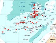
Occupied features
A feature is occupied by a country if one of the following is true:- Soldiers and/or civilian citizens of a country are present in the feature, either by building structures over the feature to house the citizens (most features are of this type) or by manning a ship anchored over the feature (Philippine-occupied Irving Reef is of this type).
- Regularly visited by soldiers of a country, not necessarily having soldiers present in it 24 hours. These features must lie near (within 9 miles (14 km)) a feature occupied by the country in the way of the first condition. Presence of structures is not necessary. This is the case of Philippine-occupied Flat Island and Lankiam Cay where soldiers stationed at Nanshan Island and Loaita Island respectively, regularly visit on a daily basis.
The effective visible distance of horizon from a 15 meter (typical large structure) height above sea-level is 9 miles (14 km). This makes features occupied by the second condition to be also labeled as "occupied" since they can be guarded far away. However not all features within the 9 miles (14.5 km) radius can be considered as absolutely occupied. This is especially true for features that lie between and within 9 miles (14.5 km) of two or more features occupied by different countries. (See Virtually Occupied or Controlled table)
| Int'l Name | Local Names | Description | Area (ha.) |
| Itu Aba Island |  太平島 Taiping Dao 太平島 Taiping Dao |
The largest of the Spratly islands. Located about 22 miles (35 km) south-southwest of Philippine-occupied Loiata (Kota) Island and about 6 miles (10 km) west of Vietnam-occupied Sand Cay. Covered with shrubs, coconut and mangroves. 600 soldiers stationed, lighthouse, radio and weather stations, concrete landing jetty and two wells at the SW end. Guano deposits, fringing reef. Hainan fishermen used to visit annually. In 8/93, plans were announced for a 2 km-long airstrip and a fishing port. The now only 1150-meters-long airstrip was completed in January 2008. Pineapple was once cultivated here. Occupied since September 1956, four months after Filipino Filipino people The Filipino people or Filipinos are an Austronesian ethnic group native to the islands of the Philippines. There are about 92 million Filipinos in the Philippines, and about 11 million living outside the Philippines .... Tomas Cloma claimed the islands. Part of Tizard Banks. |
46 |
 Ligaw Ligaw |
|||
 Đảo Ba Bình Đảo Ba Bình |
|||
| Ban Than Reef | 中洲礁 Jhongjhou Jiao |
Lies 3 miles (5 km) east of Itu-Aba Island and 3 miles (5 km) west of Vietnamese occupied Sand Cay. Small drying reef. Occupied since 1995. Part of Tizard Banks. | 0 |
| Bãi Bàn Than |
|||
| Total | 1 island, 1 reef | 46 |
| Int'l Name | Local Names | Description | Area (ha.) |
| Cuarteron Reef |  华阳礁 Huayang Jiao 华阳礁 Huayang Jiao |
Coral rocks only. Highest are 1.5 m high, on the north. Occupied by PRC since 1988. , has permanent reef fortresses and supply platforms able to resist winds up to 71 knots and equipped with VHF / UHF communications equipment, search radars as well as naval guns and anti-aircraft guns, which can serve as docks for Chinese navy patrol boats. Part of London Reefs. | 0 |
| Calderon |
|||
| Bãi /Đá Châu Viên |
|||
| Fiery Cross Reef/ Northwest Investigator Reef | 永暑礁 Yongshu Jiao |
Rocks up to 1 m high. All below at high tide, but has guano deposits. Occupied by PRC since 1988. "Marine observation station" built by PRC in 1988; PRC built a navy harbor by blasting, piling up and cementing coral; coconut, fir, and banyan trees planted. , designated the PRC main command headquarters; equipped with satellite data transmission, surface and air search radars; armed with at least four high-powered naval guns and several gun emplacements. Actually 3 reefs. | 0 |
| Kagitingan |
|||
| Đá Chữ Thập |
|||
| Gaven Reefs | 南薰礁 Nanxun Jiao (Northern reef) / Xinan or Duolu Jiao (S. reef) |
A sand dune, 2 m high. Has fringing reef plus a reef 2 miles (3 km) to the south, both covered at high tide, all cement and a raised metal frame with two-story buildings placed on top. Southern reef was occupied by PRC on 7/4/92. Occupied since 1988. , has permanent reef fortresses and supply platforms able to resist winds up to 71 knots and equipped with VHF / UHF communications equipment, search radars as well as naval guns and anti-aircraft guns, which can serve as docks for Chinese navy patrol boats. Part of Tizard Banks. | 0 |
| Burgos |
|||
| Đá Ga Ven |
|||
| Hughes Reef | 东门礁 Dongmen Jiao |
Lies 9 miles (14 km) to the east of Sin Cowe Island. Naturally above water at least at low tide. Occupied since 1988. Part of Union Banks. | 0 |
| Johnson South Reef | 赤瓜礁 Chigua Jiao |
Contiguous with Vietnam-occupied Collins Reef which lies 4 miles (6 km) away northwest. Naturally above water only at low tide, but many rocks above water at high tide. Site of 1988 PRC/Vietnam clash. Occupied since 1988. , has permanent reef fortresses and supply platforms able to resist winds up to 71 knots and equipped with VHF / UHF communications equipment, search radars as well as naval guns and anti-aircraft guns, which can serve as docks for Chinese navy patrol boats. Part of Union Banks. | 0 |
| Mabini |
|||
| Đá Gạc Ma |
|||
| Mischief Reef | 美济礁 Meiji Jiao |
Some rocks above water at low tide. Has a lagoon. In February 1995, PRC had built a wooden complex on stilts here, starting its formal occupation of the feature. In 1999, the Philippines protested over this structures claiming that it is a military outpost and it poses danger to Philippine security and national defense, being 130 miles (209 km) from Palawan. PRC claims it is a shelter for fishermen. , the "shelters" were equipped with satellite communications and radars and Panganiban Reef has four building complexes with 13 multi-storey buildings. Fifty Chinese Marines are permanently stationed there. PRC has undertaken several lagoon construction activities at Panganiban Reef, suitable for establishing pre-positioned bases in the South China Sea, enabling Beijing to project its influence and power in the disputed islands. | 0 |
| Panganiban |
|||
| Đá Vành Khăn |
|||
| Subi Reef | 渚碧礁 Zhubi Dao |
Lies 16 miles (26 km) southwest of Philippine-occupied Thitu Island (Pagasa Island). Naturally above water only at low tide. Surrounds a lagoon. , PRC has built a permanent reef fortress and supply platform that can house 160 troops. This garrison has a helipad and is armed with four twin barrel 37-millimeter naval guns. | 0 |
| Zamora |
|||
| Đá Su Bi |
|||
| First Thomas Reef | 信义礁 Xinyi Jiao 信義暗沙 Xinyi Ansha |
A few rocks are permanently above sea level. Much of the reef is above water at low tide. Encloses a lagoon. | 0 |
| Bulig |
|||
| Bãi Suối Ngà |
|||
| Whitson Reef | 牛轭礁 Niu'e Jiao |
Some rocks naturally above water at high tide. Part of Union Banks. | 0 |
| Đá Ba Đầu |
|||
| Total | 9 reefs | 0 |
| Int'l Name | Local Names | Description | Area (ha.) |
| Flat Island | Patag |
The fourteenth largest Spratly island. About 6 miles (10 km) southwest of Philippine-occupied Lawak Island (Nanshan Island). It changes its shape seasonally. The sand build up will depend largely on the direction of prevailing wind and waves. It takes the shape of an elongated one for some years now and a shape like that of a crescent moon for few years ago and it formed the shape of a letter "S" in the past. Like Panata Island (Lankiam Cay), it is also barren of any vegetation. No underground water source is found in the island. Presently, this island serves only as a military observation post for the Municipality of Kalayaan Kalayaan, Palawan Kalayaan is a 6th class municipality in the province of Palawan, Philippines. According to the latest census, it has a population of 114 people in 12 households.... . A low, flat, sandy cay, 240 by 90 m, subject to erosion. Has a nearby reef which is above water at high tide. With large guano deposits. No vegetation. Several soldiers stationed. |
0.57 |
| 费信岛 費信島 Feixin Dao |
|||
| Đảo Bình Nguyên |
|||
| Lankiam Cay Cay A cay , also spelled caye or key, is a small, low-elevation, sandy island formed on the surface of coral reefs. Cays occur in tropical environments throughout the Pacific, Atlantic and Indian Oceans , where they provide habitable and agricultural land for hundreds of thousands of people... |
Panata |
The fifteenth largest and the smallest Spratly island. Located 8 miles (13 km) northeast of Philippine-occupied Kota Island (Lankiam Cay). A few years ago this island has a surface area of more than 5 hectares but strong waves brought by a strong typhoon washed out the sandy surface (beach) of the island leaving behind today the calcarenite foundation that can be seen at low tide. Several soldiers stationed. Part of Loaita Banks. | 0.44 |
| 杨信沙洲 楊信沙洲 Yangxin Shazhou |
|||
| Cồn San Hô Lan Can |
|||
| Loaita Island | Kota |
The tenth largest Spratly island. Located 22 miles (35 km) southeast of Philippine-occupied Pag-asa Island (Thitu Island) and 22 miles (35 km) north-northeast of the ROC-occupied Itu Aba Island. It fringes the Laoita bank and reef. Its calcarenite outcrop is visible along its western side at low tide. The present shape of the island indicates sand buildup along its eastern side. The anchor-shaped side will eventually connect with the northern portion as the sand buildup continues thereby creating another mini-lagoon in the process. The presence of migrating sea birds adds to the high phosphorus contents of the sand found in the island. Occasionally, giant sea turtles are reported to be laying their eggs in the island. Covered with mangrove bushes, above which rose coconut palms and other small trees. Several soldiers stationed. Occupied since 1968. Part of Loaita Banks. | 6.45 |
| 南钥岛 南鑰島 Nanyue Dao |
|||
| Đảo Loại Ta |
|||
| Nanshan Island | Lawak |
The eighth largest Spratly island. Located 98 miles (157.7 km) east of Pag-asa (Thitu Island). This island is a bird sanctuary. Its surroundings are highly phosphatized that superphosphate materials can be mined out on a small-scale basis. Near the fringes of the breakwaters (approx. 2 miles (3 km) from the island), intact hard coral reefs were observed to retain their natural environment and beautiful tropical fishes were seen colonizing these coral beds of varying colors. Covered with coconut trees, bushes and grass. 580 m long, on the edge of a submerged reef. Several soldiers stationed. Has a small airstrip. | 7.93 |
| 马欢岛 馬歡島 Mahuan Dao |
|||
| Đảo Vĩnh Viễn |
|||
| Northeast Cay Northeast Cay Northeast Cay is the fifth largest Spratly island and the third largest among Philippine-occupied Spratly islands. Its land area is 12.7 hectares. It is only 1.75 miles north of Vietnamese-occupied Southwest Cay and it can bee seen before the horizon. It is located 28 miles northwest of... |
Parola |
The fifth largest Spratly island. Only 1.75 miles (2.82 km) north of Vietnamese-occupied Southwest Cay and can be seen before the horizon. Located 28 miles (45 km) northwest of Philippine-occupied Pag-asa (Thitu Island). Some of its outcrops are visible on its western side. It has high salinity groundwater and vegetation limited to beach type of plants. The corals around the island were mostly destroyed by rampant use of dynamite fishing and cyanide method employed by foreign fishing boats in the past. Covered with grass and thick trees. Much of the ringing reef is above water at high tide. Supported a beacon in 1984. Has Guano deposits. Several soldiers stationed. Satellite photography suggests it may have an airstrip. Occupied since 1968. Part of North Danger Reef. | 12.7 |
| 北子岛 Beizi Dao 北子礁 Beizi Jiao |
|||
| Đảo Song Tử Đông |
|||
| Thitu Island Thitu Island Thitu Island , having an area of 37.2 hectares is the second largest Spratly Island and the largest of all Philippine-occupied Spratly Islands. It lies about west of Puerto Princesa City... |
Pag-asa |
The second largest Spratly island. Serves as the poblacion Poblacion A Poblacion or Población, literally "town" or "Population" in Spanish, is the name commonly used for the central barangay or barangays of a Philippine city or municipality. Common features of the poblacion include a town plaza, church, market, school and town hall. It is sometimes shortened to... for the Municipality of Kalayaan, Palawan, Phils Kalayaan, Palawan Kalayaan is a 6th class municipality in the province of Palawan, Philippines. According to the latest census, it has a population of 114 people in 12 households.... . It is covered with trees and has a variety of fauna. It is home to some 300+ civilians (including children) and over 50 soldiers. Other islands are expected to be populated before 2010. Population is regulated to protect the islands' flora and fauna and to avoid tension with other countries. It has 1.4 km airstrip, a marina Marina A marina is a dock or basin with moorings and supplies for yachts and small boats.A marina differs from a port in that a marina does not handle large passenger ships or cargo from freighters.... , water filtering plant, power generator and a commercial communications tower (by Smart Communications Smart Telecom Smart Telecom is an Irish telecom operator that started as a phone card seller. It is also the third largest provider of cost-sensitive telecom services sector in Ireland, behind the incumbent operator Eircom and BT Ireland. It currently has an estimated 50,000 land-line customers and 18,000... ). The Philippines' Department of Tourism is making improvements to the island to make it profitable. Occupied since 1968. Part of Thitu Reefs. |
37.2 |
| 中业岛 中業島 Zhongye Dao |
|||
| Đảo Thị Tứ |
|||
| West York Island West York Island West York Island or Likas Island , having an area of 18.6 hectares, is the third largest island of the Spratly Islands chain in South China Sea. It is the second largest island among Philippine-occupied Spratly islands. It is wide at its widest part; and in length... |
Likas |
The third largest Spratly island. This island is located 47 miles (76 km) northeast of Pag-asa (Thitu Island). Outcrops are visible on the southern and eastern portion of the island during low tides. This island is considered a sanctuary for giant sea turtles that lay their eggs on the island all year round. The high salinity of the ground water in the island retards the growth of introduced trees like coconuts, ipil-ipil, and other types. Only those endemic to the area that are mostly beach type of plants thrive and survive the hot and humid condition especially during the dry season. Has an observation post. Several soldiers stationed. | 18.6 |
| 西月岛 西月島 Xiyue Dao |
|||
| Đảo Bến Lạc, Đảo Dừa |
|||
| Commodore Reef | Rizal |
A sand "cay", 0.5 m high, surrounded by two lagoons. Parts of reef above water at high tide. It is a typical reef lying underwater and is now being manned by a military contingent based and established in the area. Some structures. Several soldiers stationed. Occupied since 1978. | 0 |
| 司令礁 司令礁 Siling Jiao |
|||
| Đá Công Đo |
|||
 Terumbu Laksamana Terumbu Laksamana |
|||
| Irving Reef | Balagtas |
Naturally above water only at low tide. A very small cay lies at northern end. Some structures. Several soldiers stationed. | 0 |
| 火艾礁 火艾礁 Huo'ai Jiao |
|||
| Đảo Cá Nhám |
|||
| Second Thomas Reef | Ayungin |
A shallow reef. It is close to Chinese-occupied Mischief Reef. It was occupied by the Philippines in 1999, after the 1995 controversial Chinese occupation of Mischief Reef, to put pressure on China not to occupy any features further which lie near the Philippines. | 0 |
| 仁爱礁 Ren'ai Jiao 仁愛暗沙 Ren'ai Ansha |
|||
| Total | 7 islands, 3 reefs | 83.89 |
| Int'l Name | Local Names | Description | Area (ha.) |
| Amboyna Cay | Datu Kalantiaw |
The thirteenth largest Spratly island. Two parts: East part consists of sand and coral, west part is covered with guano. Has fringing reef. An obelisk, about 2.7 m high, stands on the SW corner. Little vegetation. Lighthouse operational since May 1995. Heavily fortified. | 1.6 |
| 安波沙洲 Anbo Shazhou |
|||
| Đảo An Bang |
|||
| Pulau Amboyna Kecil |
|||
| Namyit Island Namyit Island Namyit Island or Nam Yet Island is one of the islands of Spratly Islands in South China Sea. With an area of 5.3 hectares, it is the twelfth largest Spratly island and the fifth largest among the Vietnamese-occupied Spratly islands. It is covered with small trees, bushes and grass, has a fringing... |
Binago |
The twelfth largest Spratly island. Covered with small trees, bushes and grass. Has a fringing reef and is inhabited by sea birds. The island is inhabited by an unknown number of Vietnamese soldiers and in the deep waters fronting the south side it is said that a submarine base is situated. Occupied since 1975.Part of Tizard Banks. | 5.3 |
| 鸿庥岛 Hongxiu Dao |
|||
| Đảo Nam Yết |
|||
| Sand Cay | Bailan |
The ninth largest Spratly island. Lies 6 miles (10 km) to the east of Taiwan-occupied Itu Aba Island. Covered with trees and bushes. Fringing reef partly above water at low tide. This feature is commonly confused with Sandy Cay. Occupied since 1974. Part of Tizard Banks. | 7 |
| 敦谦沙洲 Dunqian Shazhou |
|||
| Đảo /Đá Sơn Ca |
|||
| Sin Cowe Island Sin Cowe Island Sin Cowe Island or Sinh Ton Island is an island in the Spratly Islands in the South China Sea. With an area of 8 hectares, it is the seventh largest Spratly island and the third largest among Vietnamese-occupied Spratly islands. It has fringing reef which is above water at low tide... |
Rurok |
The seventh largest. Has fringing reef which is above water at low tide. Occupied since 1974. Part of Union Banks. | 8 |
| 景宏岛 Jinghong Dao |
|||
| Đảo Sinh Tồn |
|||
| Southwest Cay Southwest Cay Southwest Cay or Song Tu Tay Island is an islet in the Spratly Islands. With an area of 12 hectares, it is the sixth largest Spratly island and the second largest among the Vietnamese-occupied Spratly islands. It holds the archipelago's highest point, at 4 meters above sea level. It is about 1.75... |
Pugad |
The sixth largest Spratly island. Only 1.75 miles (2.82 km) from Northeast Cay and can be seen before the horizon. Previously a breeding place for birds and covered with trees and guano. Export of guano was once carried out "on a considerable scale." Fringing reef partly above water at high tide. Vietnam erected its first lighthouse in the Spratlys here in October 1993 and built an airstrip. Has a three-story building, garrisoned by soldiers. Philippine military controlled the island before early 1970s. South Vietnamese forces (Republic of Vietnam) invaded the island in 1975, when Filipino soldiers guarding the island attended the birthday party of their commanding officer based in the nearby Northeast Cay. A confirmed report came out that Vietnamese prostitutes were sent by Vietnamese officials to the birthday party, supposedly a sign of good brotherhood between the forces, but was actually used to lure the Filipino soldiers guarding the island. Filipino forces apparently planned on attacking the island, thus it would have led to a war, but Vietnamese forces were able to erect a huge garrison in the island within few weeks, forcing Filipino officials to abort the plan. Since then, more soldiers were assigned to Parola Island (North East Cay), to avoid it from happening again. This was confirmed by interviews with soldiers involved in an episode of the defunct ABS-CBN ABS-CBN ABS–CBN Corporation is a Philippine-based media conglomerate. It is the Philippines' largest media and entertainment conglomerate. The corporation was the merger of Alto Broadcasting System which at that time owned by James Lindenberg and Antonio Quirino, and the Chronicle Broadcasting Network ... 's Magandang Gabi Bayan (Good Evening Nation) program. See Policies, activities and history of the Philippines in Spratly Islands#Southwest Cay invasion for more details. Part of North Danger Reef. |
12 |
| 南子岛 Nanzi Dao 南子礁 Nanzi Jiao |
|||
| Đảo Song Tử Tây |
|||
| Spratly Island (proper) Spratly Island (proper) Spratly Island or Truong Sa Island is one of the islands of Spratly Islands in South China Sea. It is controlled by Vietnam since 1974, and is also claimed by the People's Republic of China, the Republic of China and the Philippines... / Storm Island |
Lagos |
The fourth largest Spratly island. 2.5 m high, flat. Covered with bushes, grass, birds and guano. 5.5 m-high obelisk at southern tip. Has landing strip, and a fishing port. Fringing reef is above water at low tide. Some structures with soldiers stationed. Occupied since 1974. | 13 |
| 南威岛 Nanwei Dao |
|||
| Đảo Trường Sa |
|||
| Alison Reef | De Jesus |
Naturally above water only at low tide. Encloses a lagoon. | 0 |
| 六门礁 Liumen Jiao |
|||
| Bãi Tốc Tan |
|||
| Barque Canada Reef/ Lizzie Weber Reef | (Barque Canada Reef) Magsaysay |
Coral. Highest rocks are 4.5 m high, at SW end. Much of reef is above water at high tide. Some sandy patches. 18 miles (29 km) long. Its military structures were recently upgraded. Occupied since 1987. | 0 |
| (Lizzie Weber Reef) Mascarado |
|||
| 柏礁 Bai Jiao |
|||
| Bãi Thuyền Chài |
|||
| Terumbu Perahu |
|||
| Central London Reef | Gitnang Quezon |
SW part is a sandbank which barely submerges at high tide. The rest is coral reef, awash, surrounding a lagoon. Occupied since 1978. Part of London Reefs. | 0 |
| 中礁 Zhong Jiao |
|||
| Đảo Trường Sa Đông |
|||
| Collins Reef/ Johnson North Reef | Roxas |
Lies 8 miles (13 km) southwest of Vietnam-occupied Sin Cowe Island. Connected to Johnson South Reef. A "coral dune" is located at the southeast corner, above the high tide line. Part of Union Banks. | 0 |
| 鬼喊礁 Guihan Jiao |
|||
| Đá Cô Lin |
|||
| Cornwallis South Reef | Osmeña |
Naturally above water only at low tide. Encloses a lagoon. Occupied since 1988. | 0 |
| 南华礁 Nanhua Jiao |
|||
| Đá Núi Le |
|||
| Great Discovery Reef | Paredes |
Several rocks are above water at high tide. Most of reef is above water at low tide. Has lagoon. Occupied since 1988. | 0 |
| 大现礁 Daxian Dao |
|||
| Đá Lớn |
|||
| East London Reef | Silangang Quezon |
Rocks up to 1 m high. Encloses a lagoon. Occupied since 1988. Part of London Reefs. | 0 |
| 东礁 Dong Jiao |
|||
| Đá Đông |
|||
| Grierson Reef | Julian Felipe |
A sand cay with fringing reef. Some references tell that there exist a Sin Cowe East Island. This island may be Grierson Reef. It was probably called Sin Cowe East Island because it is located to the east of Sin Cowe Island and that its sand bar is visible during low tides, making it an island. Due to convention that an island must always be visible even at highest tides, Grierson Reef is not considered as an island in this list. Its sand bar area is about 12 hectares. Part of Union Banks. | 0 |
| 染青沙洲 Ranqing Shazhou |
|||
| Higgens Reef | 屈原礁 Quyuan Jiao |
Lies 6 miles (10 km) southeast of Vietnam-occupied Sin Cowe Island. Only above water at low tide. Part of Union Banks. | 0 |
| Đá Hi Ghen, Đá Hi Gen |
|||
| Ladd Reef | 日积礁 Riji Jiao |
Naturally above water at low tide. Has coral lagoon. Occupied since 1988. | 0 |
| Đá Lát |
|||
| Lan(d)sdowne Reef | Pagkakaisa |
Sand dune, with fringing reef. Part of Union Banks. | 0 |
| 琼礁 Qiong Jiao |
|||
| Đá Len Đao |
|||
| Pearson Reef | Hizon |
Two sand "cays", 2 m and 1 m high, lie on the edges of a lagoon. Parts of the surrounding reef are above water at high tide. Occupied since 1988. | 0 |
| 毕生礁 Bisheng Jiao |
|||
| Đảo Phan Vinh |
|||
| Petley Reef | Juan Luna |
Naturally above water only at low tide, some small rocks might stand above high water. Occupied since 1988. Part of Tizard Banks. | 0 |
| 舶兰礁 Bolan Jiao |
|||
| Đá Núi Thị |
|||
| Pigeon Reef/ Tennent Reef | Lopez-Jaena |
Numerous rocks are naturally above the high tide line. Encloses a lagoon. Occupied since 1988. | 0 |
| 无乜礁 Wumie Jiao |
|||
| Đá Tiên Nữ |
|||
| South Reef | Timog |
Lies about 2.5 miles (4 km) southwest of Vietnam-occupied Southwest Cay. A tiny cay appears atop this reef on the most detailed map available. On the southwest end of North Danger Reef. Fringing reef is above water at low tide. Occupied since 1988. Part of North Danger Reef. | 0 |
| 奈罗礁 Nailuo Jiao |
|||
| Đá Nam |
|||
| West London Reef | Kanlurang Quezon |
East part is sand "cay", 0.6 m high. West part is coral reef which is above water only at low tide. Between them is a lagoon. Vietnam erected a lighthouse here in May or June 1994. Part of London Reefs. | 0 |
| 西礁 Xi Jiao |
|||
| Đá Tây |
|||
| Rifleman Bank (containing Bombay Castle) | 南薇滩 Nanwei Tan |
Shallowest natural depth is 3 m, called Bombay Castle. Sand and coral. Occupied since 1989. | 0 |
| Bãi Vũng Mây |
|||
| Prince of Wales Bank | 广雅滩 Guangya Tan |
Shallowest natural depth is 7 m. Has corals. Occupied since 1989. | 0 |
| Bãi Phúc Tần |
|||
| Grainger Bank | 李准滩 Lizhun Tan |
Shallowest natural depth is either 9 m or 11 m. Occupied since 1991. | 0 |
| Bãi Quế Đường |
|||
| Alexandra Bank | 人骏滩 Renjun Tan |
Shallowest natural depth is 5 m. Occupied since 1991. | 0 |
| Bãi Phúc Tần |
|||
| Prince Consort Bank | 西卫滩 Xiwei Tan |
Shallowest natural depth is 9 m. Occupied since 1990. | 0 |
| Bãi Phúc Nguyên |
|||
| Vanguard Bank | 万安滩 Wan'an Tan |
Shallowest natural depth is 16 m. Vietnam has run three "economic technological service stations" in this area since July 1994. Occupied since 1989. | 0 |
| Bãi Tư Chính |
|||
| Total | 6 islands, 16 reefs, 6 banks | 46.9 |
| Int'l Name | Local Names | Description | Area (ha.) |
| Swallow Reef/ Island Swallow Reef Swallow Reef, known as Layang-Layang Island in Malaysia, Danwan Jiao in China, Celerio in the Philippines and Đá Hoa Lau in Vietnam, is an uninhabited oceanic atoll of the Spratly Islands situated approximately 300 km northwest of Kota Kinabalu, Sabah. Swallow Reef has a total land area of... |
Celerio |
The eleventh largest Spratly island. Treeless cay and rocks up to 3 m high surround a lagoon. Malaysia has drawn territorial seas around this and Amboyna Cay. Some 70 plus soldiers stationed here maintain a beacon. Has a fishing port and a 15-room diving resort, including a 1.5 km airstrip. Present land mass is reclaimed, making it the first artificial island Artificial island An artificial island or man-made island is an island or archipelago that has been constructed by people rather than formed by natural means... in Spratly. Occupied since 1983. |
6.2 |
| Đá Hoa Lau |
|||
| 弹丸礁 Danwan Jiao |
|||
| Terumbu Layang Layang |
|||
| Ardasier Reef | Antonio Luna |
Naturally above water only at low tide. Encloses a lagoon. Has a few sandy patches. Several soldiers stationed. Occupied since 1986. | 0 |
| 光星仔礁 Guangxingzai Jiao |
|||
| Bãi Kiêu Ngựa |
|||
| Terumbu Ubi |
|||
| Dallas Reef | Rajah Matanda |
Naturally above water only at low tide. Encloses a lagoon. Several soldiers stationed. Malaysia is also using this reef for tourism. | 0 |
| 光星礁 Guangxing Jiao |
|||
| Terumbu Laya |
|||
| Erica Reef/ Enloa Reef | Gabriela Silang |
Above water only at low tide. Some isolated rocks on the eastern edge stand above high water. | 0 |
| 簸箕礁 Boji Jiao |
|||
| Terumbu Siput |
|||
| Investigator Shoal | Pawikan |
Above water only at low tide. Some large rocks at the western end are visible at high water. Encloses a lagoon. | 0 |
| 榆亚暗沙 Yuya Ansha |
|||
| Bãi Thám Hiểm |
|||
| Terumbu Peninjau |
|||
| Louisa Reef | 南通礁 Nantong Jiao |
Rocks 1 m high. Malaysia operates a lighthouse here. | 0 |
| Terumbu Semarang/ Barat Kecil |
|||
| Mariveles Reef | Mariveles |
A sand cay, 1.5–2 m high, surrounded by two lagoons, parts of which are above water at high tide. Several soldiers stationed. Occupied since 1986. | 0 |
| 南海礁 Nanhai Jiao |
|||
| Bãi /Đá Kỳ Vân |
|||
| Terumbu Mantanani |
|||
| Total | 1 artificial island, 5 reefs, 1 shoal | 6.2 |
Virtually occupied or controlled
An unoccupied feature that lies within 9 miles (14 km) radius of an occupied feature, provided that it does not lie between the occupied feature and another occupied feature controlled by a different country and is not within 9 miles (14.5 km) of the feature occupied by the other country, can be considered as virtually occupied. 9 miles (14.5 km) is the effective horizon distance that can be seen from a 15 meter high structure. The nearer the feature, the better.While virtually occupied features are not actual occupied features (e.g., no structures built and no soldiers are stationed or regularly visits), they are on the other hand largely controlled. If a naval vessel of another country was seen within the effective horizon of a feature and in an inconvenient direction, it can be taken as a military assault. Thus, the forces occupying the feature may attack the vessel. Claimant countries currently cannot upgrade the status of these virtually occupied features to absolutely occupied because other countries may view this as an expansion motive which clearly violates the Code of Conduct signed in 2002. Also, making the virtually occupied to absolutely occupied requires building of structures which will serve as barracks of new soldiers who will guard it. Building of structures in unoccupied (including virtually occupied) features is prohibited by the Code of Conduct.
Note that most virtually occupied features are by the Philippines. Vietnam in the past, prior to signing of the Code of Conduct, have acquired many features as much as it can. As of now, it has a total of 26 occupied features. Whenever it occupied a feature in the past, it immediately occupies features which are near to it. Example of this is South Reef which Vietnam immediately occupied after it successfully invaded Southwest Cay. Thus, no feature has been virtually controlled by Vietnam since it always occupy features which it can see within its horizon. Also, Vietnam's occupied features in Tizard and Union Banks are near other countries' occupied features. Hence, many unoccupied features near to Vietnam's occupied features in these banks also lie near other countries' occupied features. As for Malaysia, it only occupied reefs at the southern tip of the Spratly chain where features are dispersed. No other features can be found within the horizon of Malaysian-occupied features.
| Virtually Occupied by the Philippines |
|||
|---|---|---|---|
| Int'l Name | Local Names | Description | Area (ha.) |
| Loaita Cay | Melchora Aquino |
Lies 1.5 miles (2 km) south-northeast of Philippine-occupied Loaita Island. Actually, it is between two Philippine-occupied islands, the other being Lankiam Cay, but is nearer to Loita Island. A sand cay, with fringing reef naturally above water at high tide. This feature is commonly confused with Lankiam Cay. Not to be confused with Loaita Island. Part of Loiata Banks. | ?? |
| 南钥沙洲 Nanyao Shazhou |
|||
| Bãi Loại Ta |
|||
| Loaita Nan/ Loaita Southwest Reef | Magbanua |
Lies 5 miles (8 km) northwest of Philippine-occupied Loaita Island. Nearest feature occupied by other country is Subi Reef, occupied by China, lies 30 miles (48 km) northwest. Never above water. Part of Loaita Banks. | 0 |
| 双黄沙洲 Shuanghuang Shazhou |
|||
| Bãi Loại Ta Nam |
|||
| North Reef | Hilaga |
Lies 1.5 miles (2 km) northest of Philippine-occupied Northest Cay (Parola Island). Nearest feature occupied by other country is Southwest Cay, occupied by Vietnam, lies 3.5 miles (6 km) southwest. Because it is Northeast Cay which lies between Southwest Cay and North Reef, North Reef became virtually occupied by the Philippines. At NE end of North Danger Reef. Naturally above water only at low tide. The Philippines once considered building a long airstrip over this feature to ease transportation to Northeast Cay. Northeast Cay is only 12.7 hectares and it doesn't have a large coral base. This is unlike Pagasa Island (Thitu Island) were a long airstrip had been constructed adjacent to the island by reclaiming portions of Pagasa's large coral base. Hence, the Philippines cannot build a long airstrip in Northeast Cay, forcing them to consider building it in North Reef. However, though virtually occupied, they cannot build such airstrip in North Reef because the Code of Conduct prohibits it. Part of North Danger Reef. | 0 |
| 贡士礁 Gongshi Jiao |
|||
| Sandy Cay/ Extension Reef | 铁线礁 Tiexian Jiao |
Lies 5 miles (8 km) west of Philippine-occupied Thitu Island. Nearest feature occupied by other country is Subi Reef, occupied by China, lies 13 miles (21 km) southwest. A low sand cay; fringing reef above water at high tide. | ?? |
| Virtually Occupied by China |
|||
| Int'l Name | Local Names | Description | Area (ha.) |
| Kennan Reef | 西门礁 Ximen Jiao (Kennan) |
Lies just 1 miles (2 km) west of PRC-occupied Hughes Reef. Nearest features occupied by other country is Vietnam-occupied Sin Cowe Island and Higgens Reef, both lies about 9 miles (14 km) west and southwest respectively. Because China is very near compared to Vietnam, Kennan Reef became virtually occupied by China. It actually causes many references to be confused on which feature between Hughes and Kennan is actually occupied by China. Naturally above water at least at low tide. | 0 |
| Đá Ken Nan |
|||
| Edmund Reef | 南门礁 Nanmen Jiao |
Lies 4 miles (6 km) east of Vietnam-occupied Sin Cowe Island and 4 miles (6 km) west of Kennan Reef. Part of Union Banks. | 0 |
| Hallet Reef | 安乐礁 Anle Jiao |
Lies 1 miles (2 km) to the northeast of Hughes Reef. Part of Union Banks. | 0 |
| Holiday Reef | 长线礁 Changxian Jiao |
Above water only at low tide. Part of Union Banks. | 0 |
| Empire Reef | 主权礁 Zhuquan Jiao |
Above water only at low tide. Part of Union Banks. | 0 |
| Eldad Reef | 安达礁 Anda Jiao |
Only a few large rocks are naturally above water at high tide. Part of Tizard Banks. | 0 |
| Malvar |
|||
| Burgai |
|||
Unoccupied features
| The reefs, shoals, etc. to the east of the 116°E meridian 116th meridian east The meridian 116° east of Greenwich is a line of longitude that extends from the North Pole across the Arctic Ocean, Asia, the Indian Ocean, Australasia, the Southern Ocean, and Antarctica to the South Pole.... are closely guarded by the Philippine Navy Philippine Navy The Philippine Navy is the naval arm of the Armed Forces of the Philippines . Its official name in Filipino is Hukbong Dagat ng Pilipinas, literally, "Sea Force of the Philippines".... and Air Force Philippine Air Force The Philippine Air Force is the air force of the Republic of the Philippines, and one of the three main services of the Armed Forces of the Philippines. Its official name in Filipino is Hukbong Himpapawid ng Pilipinas.... . Though not occupied, the Philippines undeniably has control over these features which are less 100 miles (160.9 km) from the Palawan Palawan Palawan is an island province of the Philippines located in the MIMAROPA region or Region 4. Its capital is Puerto Princesa City, and it is the largest province in the country in terms of total area of jurisdiction. The islands of Palawan stretch from Mindoro in the northeast to Borneo in the... west coast (note: Scarborough Shoal Scarborough Shoal Scarborough Shoal or Scarborough Reef , more correctly described as a group of islands and reefs in an atoll shape than a shoal, is located between the Macclesfield Bank and Luzon, Philippines in the South China Sea. As with most of the landforms in this sea, the sovereignty of the area is disputed... is 100 miles (160.9 km) from Zambales Zambales Zambales is a province of the Philippines located in the Central Luzon region. Its capital is Iba. Zambales borders Pangasinan to the north, Tarlac and Pampanga to the east, and Bataan to the south. The province lies between the South China Sea and the Zambales Mountains. With a land area of... west coast). There are many Filipino Filipino people The Filipino people or Filipinos are an Austronesian ethnic group native to the islands of the Philippines. There are about 92 million Filipinos in the Philippines, and about 11 million living outside the Philippines .... fishermen in this region, who cooperate closely with the Philippine Navy. Non-Filipino fishermen are tolerated in this region, provided that they comply with Philippine laws. The press in the Philippines have reported many arrests of Chinese fishermen by the Philippine Navy because of illegal fishing methods and catching of endangered sea species, both in this region and in the Sulu Sea Sulu Sea The Sulu Sea is a body of water in the southwestern area of the Philippines, separated from the South China Sea in the northwest by Palawan and from the Celebes Sea in the southeast by the Sulu Archipelago. Borneo is found to the southwest and Visayas to the northeast.Sulu Sea contains a number of... . Philippine military presence in this region intensified after the 1995 Mischief Reef incident. The Philippine Air Force has been active in striking even the markers set up by other countries to guide the latter's naval forces in this region. |
|||
| Int'l Name | Local Names | Description | Area (ha.) |
| Amy Douglas Bank or Reef | Mahiwagang Diwata |
Lies north of Palawan Passage. Awash at low tide. | 0 |
| 安塘滩 Antang Tan, 安塘礁 Antang Jiao |
|||
| Bombay Shoal | Abad Santos |
Several rocks are exposed at low tide. Surrounds a lagoon. | 0 |
| 蓬勃暗沙 Pengbo Ansha |
|||
| Boxall Reef | Rajah Sulayman |
Above water only at low tide. | 0 |
| 牛车轮礁 Niuchelun Jiao |
|||
| Carnadic Shoal | 红石暗沙 Hongshi Ansha |
0 | |
| Director Shoal/Reef | Tamban |
0 | |
| 指向礁 Zhixiang Jiao |
|||
| Ganges Reef | Palma |
0 | |
| 恒礁 Heng Jiao |
|||
| Glasgow Bank | Aguinaldo |
Some sources say this area is occupied by the Philippines due to its proximity to the Commodore Reef. | 0 |
| 双礁 Shuang Jiao |
|||
| Half Moon Shoal | Hasa-hasa |
Several rocks on the eastern side rise one to two feet above high tide. Encloses a lagoon. | 0 |
| 半月礁 Banyue Jiao |
|||
| Bãi Trăng Khuyết |
|||
| Hardy Reef | Sakay |
Naturally above water only at low tide. Surrounds a narrow strip of sand. | 0 |
| 半路礁 Banlu Jiao |
|||
| Hopkins Reef | 火星礁 Huoxing Jiao |
0 | |
| Investigator Northeast Shoal | Dalagang Bukid |
Lies only a few miles west of Palawan. Naturally above water at low tide. | 0 |
| 海口礁 Haikou Jiao |
|||
| Iroquois Reef | Del Pilar |
Lies east of both Philippine-occupied Nanshan Island and Flat Island. Above water only at low tide. | 0 |
| 鲎藤礁 Houteng Jiao |
|||
| Leslie Bank | Urduja |
0 | |
| 勇士滩 Yongshi Tan |
|||
| Lord Auckland Shoal | Lapu-Lapu |
0 | |
| 莪兰暗沙 Elan Ansha |
|||
| Lys Shoal | Bisugo |
0 | |
| 乐斯暗沙 Lesi Ansha |
|||
| North East Shoal | Ponce |
Lies only a few miles north of Commodore Reef. Above water only at low tide. | 0 |
| 校尉暗沙 Xiaowei Ansha |
|||
| Pennsylvania North Reef | 阳明礁 Yangming Jiao |
0 | |
| Pennsylvania South Reef | 孔明礁 Kongming Jiao |
0 | |
| Reed Tablemount (including Nares Bank and Marie Louise Bank) |
Recto |
Shallowest natural depth is 9 m. About 2500 square miles (6,475 km²) in area. The Philippines occupied this feature in 1971 and a Philippine-Sweden joint oil-exploration followed afterwards. However, China protested this act of the Philippines saying that this tablemount which center lies 100 miles (160.9 km) from the Philippines is part of China's territories. After that, the Philippines tried asking China for a joint effort but China declined, arguing that the Philippines has no right in this feature. Presently, this feature is largely controlled by the Philippines. | 0 |
| 礼乐滩 Liyue Tan |
|||
| Bãi Cỏ Rồng |
|||
| Royal Captain Shoal | Kanduli |
A few rocks are above water at low tide. Surrounds a lagoon. | 0 |
| 舰长礁 Jianzhang Jiao |
|||
| Sabina Shoal | Escoda |
It encloses two lagoons, naturally above water at low tide. Lies east of the Philippine-occupied Second Thomas Reef. | 0 |
| 仙宾礁 Xianbin Jiao |
|||
| Sandy Shoal | Mabuhangin |
0 | |
| 神仙暗沙 Shenxian Ansha |
|||
| Seahorse Shoal or Seashore Shoal | Baybayin Dagat |
Lies north of Palawan Passage | 0 |
| 海马滩 Haima Tan |
|||
| Stag Shoal | Panday Pira |
0 | |
| 隐遁暗沙 Yindun Ansha |
|||
| Southern Bank/Reef | Katimugan |
A group of features located south of Reed Tablemount. The reef includes: Magat Salamat, Tagpi, Hubo Reef, and Katimugan Banks/Reef. The area is largely controlled and used for fishing by the Philippines due to its proximity to Flat Island and Nanshan Island. | 0 |
| 南方浅滩 Nanfang Qiantan |
|||
| Templar Bank | Dalag |
0 | |
| 忠孝滩 Zhongxiao Tan |
|||
| Trident Shoal | Tatlong-tulis |
0 | |
| 永登暗沙 Yongdeng Ansha |
|||
| Viper North Shoal | Maya-maya |
0 | |
| 都护暗沙 Duhu Ansha |
|||
| Viper Shoal | Tomas Claudio |
0 | |
| 保卫暗沙 Baowei Ansha |
|||
| Malaysia claims a portion of the South China Sea together with 11 islands and other marine features in the Spratly group on the basis that they are within its continental shelf. These shoals lie off the North-Western coast of Sarawak over an area of 100 km in the South China Sea, as such, they are largely controlled by Malaysia. | |||
| Int'l Name | Local Names | Description | Area (ha.) |
| North Luconia Shoals | 北康暗沙 Beikang Ansha |
0 | |
| Gugusan Beting Raja Jarum |
|||
| South Luconia Shoals | 南康暗沙 Nankang Ansha |
0 | |
| Gugusan Beting Patinggi Ali |
|||
| James Shoal | 曾母暗沙 Zengmu Ansha |
Shallowest natural depth is 17.5 m. | 0 |
| These are the unoccupied features. Some sources say that some of these features are occupied by Vietnam or China but most sources, including the latest, say that they are not occupied. Occupation are probably confused because the said reefs are very close to occupied features. There are many unoccupied features in the Spratly chain. The current Code of Conduct prohibits any country from acquiring new features. Many of these features are actually in between and near two or more occupied features of different countries. Thus, they serve like buffer zone Buffer zone A buffer zone is generally a zonal area that lies between two or more other areas , but depending on the type of buffer zone, the reason for it may be to segregate regions or to conjoin them.... s. Example of this is Jones Reef which lies almost exactly between PRC-occupied Hughes Reef and Vietnamese-occupied Higgens Reef. |
|||
| Int'l Name | Local Names | Description | Area (ha.) |
| Alicia Annie Reef | Arellano |
A sand "cay", 1.2 m high. Many rocks above high tide line. | 0 |
| 仙娥礁 Xian'e Jiao |
|||
| Đá Suối Ngọc |
|||
| Coronation Bank | 康泰滩 Kangtai Tan |
0 | |
| Discovery Small Reef | Gomez |
Above water only at low tide. | 0 |
| 小现礁 Xiaoxian Jiao |
|||
| Đá Nhỏ |
|||
| Dhaulle Shoal | 逍遥暗沙 Xiaoyao Ansha |
0 | |
| Hopps Reef | Diego Silang |
Above water only at low tide. Part of Southampton Reefs. | 0 |
| 禄沙礁 Lusha Jiao |
|||
| Đá Hop |
|||
| Jackson Atoll | Quirino |
Four or five portions are above water at low tide. Encloses a lagoon. | 0 |
| 五方礁 Wufang Jiao |
|||
| Jones Reef | 漳溪礁 Zhangxi Jiao |
Lies 5 miles (8 km) south of Kennan Reef. Small reef, partly above water only at low tide. Part of Union Banks. | 0 |
| Livock Reef | (NE part) Jacinto |
Above water only at low tide. Some rocks still visible at high tide. Part of Southampton Reefs. | 0 |
| (SW part) Bonifacio |
|||
| 三角礁 Sanjiao Jiao |
|||
| Menzies Reef | Rajah Lakandula |
Awash at low tide. Part of Loaita Bank. | 0 |
| 蒙自礁 Mengzi Jiao |
|||
| Đá Men Di |
|||
| Owen Shoal | 奥援暗沙 Aoyuan Ansha |
Shallowest natural depth is 6 m. | 0 |
| Thitu Reef | 铁峙礁 Tiezhi Jiao |
Above water only at low tide. Located northeast of Thitu Island and unnamed on most maps. Part of Thitu Reefs | 0 |
Claimed features by country but occupied by other country
| Only the PRC, the ROC and Vietnam claim all of the Spratly Island Chain, including some features that are just 50 km from other countries like the Philippines and Malaysia. However, the Philippines, Malaysia and Brunei all have partial claims only. Here are the islands claimed but are not occupied by these three countries (flags refer to the country currently occupying the feature): |
| Philippines: Itu Aba Island , Amboyna Cay , Namyit Island , Sand Cay , Sin Cowe Island , Sin Cowe East Island , Southwest Cay , Spratly Island Proper , Pigeon Reef , South Reef , Ardasier Reef , Erica Reef , Investigator Shoal , Mariveles Reef , Swallow Reef/Island , Mischief Reef , Subi Reef and all of features to the east of the 116°E meridian 116th meridian east The meridian 116° east of Greenwich is a line of longitude that extends from the North Pole across the Arctic Ocean, Asia, the Indian Ocean, Australasia, the Southern Ocean, and Antarctica to the South Pole.... (unoccupied) (see Unoccupied but Largely Controlled by the Philippines subtable). |
| Malaysia: Amboyna Cay , Barque Canada Reef , Commodore Reef and Royal Charlotte Reef (unoccupied) |
| Brunei: Rifleman Bank , Louisa Reef and Owen Shoal (uncertain) |
20th century timeline
| 1900 - | Vietnam's Nguyễn Dynasty continued to assert that the state Bac Hai Company had exercised Vietnam's sovereignty in the Spratlys since the 18th century. |
| 1927 | The French ship SS De Lanessan conducted a scientific survey of the Spratly Islands |
| 1930 | France launched a second expedition with the La Malicieuse, which raised the French flag on an island called Île de la Tempête. Chinese fishermen were present on the island, but the French made no attempt to expel them. |
| 1932 | The Republic of China Republic of China The Republic of China , commonly known as Taiwan , is a unitary sovereign state located in East Asia. Originally based in mainland China, the Republic of China currently governs the island of Taiwan , which forms over 99% of its current territory, as well as Penghu, Kinmen, Matsu and other minor... sent the French government a memorandum contesting their sovereignty over the Paracels, stating that the Paracels were the extreme south of Chinese territories, based on the Chinese interpretation of the 1887 treaty ending the Sino-French War Sino-French War The Sino–French War was a limited conflict fought between August 1884 and April 1885 to decide whether France should replace China in control of Tonkin . As the French achieved their war aims, they are usually considered to have won the war... . |
| 1933 | Three French ships had taken control of nine of the largest islands and declared French sovereignty over the archipelago to the great powers including the UK, US, China and Japan, according to the principles found in the Berlin convention. France administered the area as part of Cochinchina Cochinchina Cochinchina is a region encompassing the southern third of Vietnam whose principal city is Saigon. It was a French colony from 1862 to 1954. The later state of South Vietnam was created in 1954 by combining Cochinchina with southern Annam. In Vietnamese, the region is called Nam Bộ... . Japanese companies applied to the French authority in Cochichina for phosphate mining licence in the Spratlys. |
| 1939 | The Empire of Japan Empire of Japan The Empire of Japan is the name of the state of Japan that existed from the Meiji Restoration on 3 January 1868 to the enactment of the post-World War II Constitution of... disputed French sovereignty over the islands, citing that Japan was the first country to discover the islands. Japan declared its intention to place the island group under its jurisdiction. France and the United Kingdom protested and reasserted French sovereignty claims. |
| 1941 | Japan forcibly occupied the island group and remained in control until the end of World War II, administering the area as part of Taiwan Taiwan Taiwan , also known, especially in the past, as Formosa , is the largest island of the same-named island group of East Asia in the western Pacific Ocean and located off the southeastern coast of mainland China. The island forms over 99% of the current territory of the Republic of China following... . A submarine base was established on Itu Aba. |
| 1945 | After Japan's surrender at the end of World War II, the Republic of China claimed the Spratly Islands. The Republic of China sent troops to Itu Aba, and Chinese landing forces erected sovereignty markers. |
| 1946 | France dispatched warships to the islands several times but no attempts are made to evict Chinese forces. |
| 1947 | China produced a map with 9 undefined dotted lines, and claimed all of the islands within those lines. France demanded the Chinese withdraw from the islands. |
| 1948 | France ceased maritime patrols near the islands and China withdrew most of its troops. |
| 1951 | At the 1951 San Francisco Conference Treaty of San Francisco The Treaty of Peace with Japan , between Japan and part of the Allied Powers, was officially signed by 48 nations on September 8, 1951, at the War Memorial Opera House in San Francisco, California... on the Peace Treaty with Japan, the Soviet Union proposed that the Spratlys belonged to China. This was overhelmingly rejected by the delegates. The delegates from Vietnam, which at that time was a French protectorate, declared sovereignty over the Paracel and the Spratly Islands, which was not opposed by any delegate at the conference. China did not attend the conference and was not a signatory of the treaty. |
| 1956 | Tomas Cloma, director of the Maritime Institute of the Philippines, claimed sovereignty over much of the Spratly Islands, naming his territory "Kalaya'an" ("Freedomland"). The People's Republic of China, the Republic of China, France, South Vietnam, the United Kingdom and the Netherlands all issued protests. The Republic of China and South Vietnam launched naval units to the islands, though South Vietnam left no permanent garrison. Later in the year, South Vietnam declared its annexation of the Spratly Islands as part of its Phước Tuy Province Phuoc Tuy Province Phước Tuy Province was a province of South Vietnam. It now mostly corresponds to Ba Ria-Vung Tau Province, just southeast of Ho Chi Minh City.... . |
| 1958 | The People's Republic of China issued a declaration defining its territorial waters which encompassed the Spratly Islands. North Vietnam's prime minister, Phạm Văn Đồng, sent a formal note to Zhou Enlai Zhou Enlai Zhou Enlai was the first Premier of the People's Republic of China, serving from October 1949 until his death in January 1976... , stating that the Government of the Democratic Republic of Vietnam respects the decision on the 12 nautical mile limit of territorial waters. Both the South Vietnamese government and the communist revolutionary movement in South Vietnam continued to assert that the Spratlys belonged to Vietnam. |
| 1961-3 | South Vietnam South Vietnam South Vietnam was a state which governed southern Vietnam until 1975. It received international recognition in 1950 as the "State of Vietnam" and later as the "Republic of Vietnam" . Its capital was Saigon... established sovereignty markers on several islands in the chain. |
| 1968 | The Philippines sent troops to three islands on the premise of protecting Kalayaan Kalayaan, Palawan Kalayaan is a 6th class municipality in the province of Palawan, Philippines. According to the latest census, it has a population of 114 people in 12 households.... citizens and announced the annexation of the Kalayaan island group. |
| 1971 | Malaysia issued claims to some of the Spratly Islands. |
| 1972 | The Philippines incorporated the Kalayaan islands into its Palawan Palawan Palawan is an island province of the Philippines located in the MIMAROPA region or Region 4. Its capital is Puerto Princesa City, and it is the largest province in the country in terms of total area of jurisdiction. The islands of Palawan stretch from Mindoro in the northeast to Borneo in the... province. |
| 1975 | The unified Vietnam declared claims over the Spratly Islands. |
| 1978 | A presidential decree from the Philippines outlined territorial claims to the islands. |
| 1979 | Malaysia published a map of its continental shelf claim, which includes twelve islands from the Spratly group. Vietnam published a white paper White paper A white paper is an authoritative report or guide that helps solve a problem. White papers are used to educate readers and help people make decisions, and are often requested and used in politics, policy, business, and technical fields. In commercial use, the term has also come to refer to... outlining its claims to the islands and disputing those of the other claimants. |
| 1982 | Vietnam published another white paper, occupied several of the islands and constructed military installations. The Philippines also occupied several more islands and constructed an air strip. |
| 1983 | Malaysia occupied Swallow Reef (Layang Layang), one of the Spratly Islands. A naval base and resort was later built at this location. |
| 1984 | Brunei established an exclusive fishing zone encompassing the Louisa Reef and neighboring areas in the southeastern Spratly Islands. |
| 1996 | The first Philippine-Vietnam Joint Marine Scientific Research Expedition in the South China Sea was conducted aboard the RPS Explorer of the Mines and Geosciences Bureau of the Department of Environment and Natural Resources. |
| 1987 | The People's Republic of China conducted naval patrols in the Spratly Islands and established a permanent base. |
| 1988 | PRC People's Republic of China China , officially the People's Republic of China , is the most populous country in the world, with over 1.3 billion citizens. Located in East Asia, the country covers approximately 9.6 million square kilometres... warships and Vietnamese transport ships had a minor clash over Johnson Reef. PRC forces prevailed and the PRC won control over some Spratly reefs for the first time in the dispute. |
| 1995 | The Philippine government revealed Chinese military structure being built at the Mischief Reefs. Philippine President Fidel Ramos ordered increased patrol of the Philippine-controlled areas, the incident leads to numerous arrests of Chinese fishermen and naval clashes with Chinese pirate vessels. |
| 2008 | Taiwan's President became the first head of state from the claimant countries to visit Spratly islands. His visit sparks criticism from other claimants. |
| 2009 | The Office of the Philippine President enacted the "Philippine Baselines Law of 2009" (RA 9522). The new law classifies the Kalayaan Island Group and the Scarborough Shoal as a "regime of islands under the Republic of the Philippines." This means that the Philippines continues to lay claim over the disputed islands. |
| 2009 | Two submissions to the Commission on the Limits of the Continental Shelf were made on May. A joint submission by Malaysia and Vietnam claims jurisdiction over their respective continental shelves out to 200 nautical miles. A lone submission by Vietnam claims jurisdiction over an extended shelf area. The People's Republic of China and the Philippines both protested the moves stating that they violated agreements made with regards to the islands. |
| 2011 | On 18 May 2011, China Mobile China Mobile China Mobile Limited is a Chinese state-owned telecommunication company that provides mobile voice and multimedia services through its nationwide mobile telecommunications network, the largest of its kind in the world... announced that its mobile phone coverage has expanded to the Spratly Islands, under the rationale that it can allow soldiers stationed on the islands, fishermen and merchant vessels within the area to use mobile services, and can also provide assistance during storms and sea rescues. The deployment of China Mobile's support over the islands took roughly one year to fulfil. |
| 2011 | In June, the Chinese navy conducted three days of exercises, including live fire drills, in the disputed waters. This was widely seen as a warning to Vietnam, which had also conducted live fire drills near the Spratly Islands. Chinese patrol boats fired repeated rounds at a target on an apparently uninhabited island, as twin fighter jets streaked in tandem overhead. 14 vessels participated in the maneuvers, staging antisubmarine and beach landing drills aimed at "defending atolls and protecting sea lanes." |
See also
- Senkaku Islands disputeSenkaku Islands disputeThe Senkaku Islands dispute concerns a territorial dispute on a group of uninhabited islands, the Senkaku Islands, which are also known as the Diaoyu or Diaoyutai Islands. These disputed islands are currently controlled and administered by Japan, and claimed by both the People's Republic of China...
- Administration Office for Xisha Islands, Zhongsha Islands and Nansha Islands
External links
- Spratlys website (pro-China)
- Paracels and Spratlys website (pro-Vietnam)
- Mariner's page of the Spratly Islands
- Taiwanese List with ~170 entries
- [ftp://rock.geosociety.org/pub/reposit/2001/2001075.pdf List of atolls with areas]
- A tabular summary about the Spratly and Paracel Islands
- Third Party Summary of the Dispute
- A collection of documents on Spratly and Paracel Islands by Nguyen Thai Hoc Foundation
- Inventory of Conflict and EnvironmentInventory of Conflict and EnvironmentThe Inventory of Conflict and Environment is a research project of the School of International Service at American University in Washington, D.C. The project makes use of computer applications in international relations research; ICE is evolving as a pattern matching tool...
(ICE), Spratly Islands Dispute