

Spanish conquest of Guatemala
Encyclopedia
Spanish colonization of the Americas
Colonial expansion under the Spanish Empire was initiated by the Spanish conquistadores and developed by the Monarchy of Spain through its administrators and missionaries. The motivations for colonial expansion were trade and the spread of the Christian faith through indigenous conversions...
within the territory of what became the modern country of Guatemala
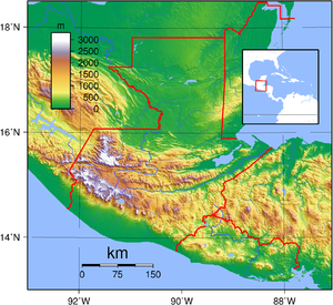
Guatemala
Guatemala is a country in Central America bordered by Mexico to the north and west, the Pacific Ocean to the southwest, Belize to the northeast, the Caribbean to the east, and Honduras and El Salvador to the southeast...
in Central America
Central America
Central America is the central geographic region of the Americas. It is the southernmost, isthmian portion of the North American continent, which connects with South America on the southeast. When considered part of the unified continental model, it is considered a subcontinent...
. Prior to the Conquest, this territory contained a number of competing Mesoamerica
Mesoamerica
Mesoamerica is a region and culture area in the Americas, extending approximately from central Mexico to Belize, Guatemala, El Salvador, Honduras, Nicaragua, and Costa Rica, within which a number of pre-Columbian societies flourished before the Spanish colonization of the Americas in the 15th and...
n kingdoms, the majority of which were Maya
Maya peoples
The Maya people constitute a diverse range of the Native American people of southern Mexico and northern Central America. The overarching term "Maya" is a collective designation to include the peoples of the region who share some degree of cultural and linguistic heritage; however, the term...
.
Many conquistador
Conquistador
Conquistadors were Spanish soldiers, explorers, and adventurers who brought much of the Americas under the control of Spain in the 15th to 16th centuries, following Europe's discovery of the New World by Christopher Columbus in 1492...
s viewed the Maya, without regard to the achievements of their civilization
Maya civilization
The Maya is a Mesoamerican civilization, noted for the only known fully developed written language of the pre-Columbian Americas, as well as for its art, architecture, and mathematical and astronomical systems. Initially established during the Pre-Classic period The Maya is a Mesoamerican...
, as "infidel
Infidel
An infidel is one who has no religious beliefs, or who doubts or rejects the central tenets of a particular religion – especially in reference to Christianity or Islam....
s" who needed to be forcefully converted and pacified. The first contact between the Maya and European explorers
European colonization of the Americas
The start of the European colonization of the Americas is typically dated to 1492. The first Europeans to reach the Americas were the Vikings during the 11th century, who established several colonies in Greenland and one short-lived settlement in present day Newfoundland...
came in the early 16th century when a Spanish
Spain
Spain , officially the Kingdom of Spain languages]] under the European Charter for Regional or Minority Languages. In each of these, Spain's official name is as follows:;;;;;;), is a country and member state of the European Union located in southwestern Europe on the Iberian Peninsula...
ship sailing from Panama
Panama
Panama , officially the Republic of Panama , is the southernmost country of Central America. Situated on the isthmus connecting North and South America, it is bordered by Costa Rica to the northwest, Colombia to the southeast, the Caribbean Sea to the north and the Pacific Ocean to the south. The...
to Santo Domingo
Hispaniola
Hispaniola is a major island in the Caribbean, containing the two sovereign states of the Dominican Republic and Haiti. The island is located between the islands of Cuba to the west and Puerto Rico to the east, within the hurricane belt...
was wrecked upon the east coast of the Yucatán Peninsula
Yucatán Peninsula
The Yucatán Peninsula, in southeastern Mexico, separates the Caribbean Sea from the Gulf of Mexico, with the northern coastline on the Yucatán Channel...
in 1511. Several Spanish expeditions followed in 1517 and 1519, making landfall on various parts of the Yucatán coast. The Spanish conquest of the Maya was a prolonged conflict, with the Maya kingdoms resisting integration into the Spanish Empire
Spanish Empire
The Spanish Empire comprised territories and colonies administered directly by Spain in Europe, in America, Africa, Asia and Oceania. It originated during the Age of Exploration and was therefore one of the first global empires. At the time of Habsburgs, Spain reached the peak of its world power....
with great tenacity, causing the Conquest of the Maya to last almost two centuries.
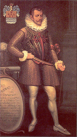
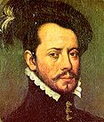
Pedro de Alvarado
Pedro de Alvarado
Pedro de Alvarado y Contreras was a Spanish conquistador and governor of Guatemala. He participated in the conquest of Cuba, in Juan de Grijalva's exploration of the coasts of Yucatan and the Gulf of Mexico, and in the conquest of Mexico led by Hernan Cortes...
arrived in Guatemala in early 1524, commanding a mixed force of Spanish conquistadors and native allies, mostly from Tlaxcala
Tlaxcala
Tlaxcala officially Estado Libre y Soberano de Tlaxcala is one of the 31 states which along with the Federal District comprise the 32 federative entities of Mexico. It is divided into 60 municipalities and its capital city is Tlaxcala....
. Placenames across Guatemala bear Nahuatl
Nahuatl
Nahuatl is thought to mean "a good, clear sound" This language name has several spellings, among them náhuatl , Naoatl, Nauatl, Nahuatl, Nawatl. In a back formation from the name of the language, the ethnic group of Nahuatl speakers are called Nahua...
placenames due to the influence of these Mexican allies, who translated for their Spanish masters. The Kaqchikel Maya initially allied themselves with the Spanish but soon rebelled against excessive Spanish demands for tribute; they did not finally surrender until 1530. In the meantime the other major highland Maya kingdoms had each been defeated in turn by the Spanish and allied warriors from both Mexico
Mexico
The United Mexican States , commonly known as Mexico , is a federal constitutional republic in North America. It is bordered on the north by the United States; on the south and west by the Pacific Ocean; on the southeast by Guatemala, Belize, and the Caribbean Sea; and on the east by the Gulf of...
and previously subjugated Maya kingdoms in Guatemala. The Itza Maya and other lowland groups in the Petén Basin
Petén Basin
The Petén Basin is a geographical subregion of Mesoamerica, located in the northern portion of the modern-day nation of Guatemala, and essentially contained within the department of El Petén...
were first contacted by Hernán Cortés
Hernán Cortés
Hernán Cortés de Monroy y Pizarro, 1st Marquis of the Valley of Oaxaca was a Spanish Conquistador who led an expedition that caused the fall of the Aztec Empire and brought large portions of mainland Mexico under the rule of the King of Castile in the early 16th century...
in 1525 but remained independent and hostile to the encroaching Spanish until 1697 when a concerted Spanish assault finally defeated the last independent Maya kingdom.
Historical sources
The sources describing the Spanish conquest of Guatemala include those written by the Spanish themselves, among them two of four letters written by conquistador Pedro de Alvarado to Hernán Cortés in 1524, describing the initial campaign to subjugate the Guatemalan highlands. These letters were dispatched to Tenochtitlan, addressed to Cortés but with a royal audience in mind; two of these letters are no longer extant. Gonzalo de Alvarado y Chávez was Pedro de Alvarado's cousin; he accompanied him on his first campaign in Guatemala and in 1525 he became the chief constable of Santiago de los Caballeros de GuatemalaSantiago de los Caballeros de Guatemala
Santiago de los Caballeros de Guatemala was the name given to the Spanish colonial capital of Guatemala in Central America. The name was first associated with the Kaqchikel Maya capital Iximche, adopted as the Spanish capital soon after the Spanish conquest of Guatemala began, in July 1524...
, the newly founded Spanish capital. Gonzalo wrote an account that mostly supports that of Pedro de Alvarado. Pedro de Alvarado's brother Jorge wrote another account to the king of Spain explaining that it was his own campaign of 1527-1529 that established the Spanish colony. Bernal Díaz del Castillo
Bernal Díaz del Castillo
Bernal Díaz del Castillo was a conquistador, who wrote an eyewitness account of the conquest of Mexico by the Spaniards for Hernán Cortés, himself serving as a rodelero under Cortés.-Early life:...
wrote a lengthy account of the Conquest of Mexico and neighbouring regions, the Historia verdadera de la conquista de la Nueva España ("True History of the Conquest of New Spain"), his account of the Conquest of Guatemala generally agrees with that of the Alvarados. His account was finished around 1568, some 40 years after the campaigns it describes. Hernán Cortés
Hernán Cortés
Hernán Cortés de Monroy y Pizarro, 1st Marquis of the Valley of Oaxaca was a Spanish Conquistador who led an expedition that caused the fall of the Aztec Empire and brought large portions of mainland Mexico under the rule of the King of Castile in the early 16th century...
described his expedition to Honduras
Honduras
Honduras is a republic in Central America. It was previously known as Spanish Honduras to differentiate it from British Honduras, which became the modern-day state of Belize...
in the fifth letter of his Cartas de Relación, in which he details his crossing of what is now Guatemala's Petén Department. Dominican
Dominican Order
The Order of Preachers , after the 15th century more commonly known as the Dominican Order or Dominicans, is a Catholic religious order founded by Saint Dominic and approved by Pope Honorius III on 22 December 1216 in France...
friar Bartolomé de las Casas
Bartolomé de Las Casas
Bartolomé de las Casas O.P. was a 16th-century Spanish historian, social reformer and Dominican friar. He became the first resident Bishop of Chiapas, and the first officially appointed "Protector of the Indians"...
wrote a highly critical account of the Spanish Conquest of the Americas and included accounts of some incidents in Guatemala. The Brevísima Relación de la Destrucción de las Indias
A Short Account of the Destruction of the Indies
A Short Account of the Destruction of the Indies is an account written by the Spanish Dominican friar Bartolomé de las Casas in 1542 about the mistreatment of the Indigenous Peoples of the Americas in colonial times and sent to then Prince Philip II of Spain.One of the stated purposes for writing...
("Short Account of the Destruction of the Indies") was first published in 1552 in Seville
Seville
Seville is the artistic, historic, cultural, and financial capital of southern Spain. It is the capital of the autonomous community of Andalusia and of the province of Seville. It is situated on the plain of the River Guadalquivir, with an average elevation of above sea level...
.
The Tlaxcalan
Tlaxcaltec
The Tlaxcalteca were an indigenous group of Nahua ethnicity that inhabited the Kingdom of Tlaxcala located in what is now the Mexican state of Tlaxcala.-Pre-hispanic history:...
allies of the Spanish who accompanied them in their invasion of Guatemala wrote their own accounts of the Conquest, these included a letter to the Spanish king protesting at the poor treatment of these allies once the campaign was over. Other accounts were in the form of questionnaires answered before colonial magistrates in order to protest and register a claim for recompense. Two pictorial accounts painted in the stylised indigenous pictographic tradition have survived, these are the Lienzo de Quauhquechollan, which was probably painted in Ciudad Vieja
Ciudad Vieja
Ciudad Vieja is a municipality in the Guatemalan department of Sacatepéquez. According to the 2002 Guatemalan Census, the municipality has a total of 25,696 people.Ciudad Vieja was the second colonial capital of the country.- History :...
in the 1530s, and the Lienzo de Tlaxcala
History of Tlaxcala
History of Tlaxcala is an illustrated codex written by and under the supervision of Diego Muñoz Camargo in the years leading up to 1585. Also known as Lienzo Tlaxcala and by its Spanish title, Historia de Tlaxcala, this manuscript highlights the religious, cultural, and military history of the...
, painted in Tlaxcala.
Accounts of the Conquest as seen from the point of view of the defeated highland Maya kingdoms are included in a number of indigenous documents, including the Annals of the Kaqchikels
Annals of the Cakchiquels
The Annals of the Cakchiquels , is a manuscript written in Kaqchikel, by Francisco Hernández Arana Xajilá in 1571, and completed by his grand son, Francisco Rojas in 1604...
, which includes the Xajil Chronicle describing the history of the Kaqchikel from their mythical creation down through the Spanish Conquest and continuing to 1619. A letter from the defeated Tz'utujil Maya nobility of Santiago Atitlán
Santiago Atitlán
Santiago Atitlán is a municipality in the Sololá department of Guatemala. The town is situated on Lago de Atitlán, which has an elevation of . The town sits on a bay of Lago Atitlan between two volcanos. Volcan San Pedro rises to west of town; Volcan Toliman rises to southeast of town. Volcan...
to the Spanish king was written in 1571, detailing the heavy exploitation of the subjugated peoples.
Francisco Antonio de Fuentes y Guzmán
Francisco Antonio de Fuentes y Guzmán
Francisco Antonio de Fuentes y Guzmán was a Guatemalan historian and poet. His only surviving work is La Recordación Florida.-Biography:...
was a colonial Guatemalan historian of Spanish descent who wrote La Recordación Florida, also called Historia de Guatemala (History of Guatemala). The book was written in 1690 and is regarded as one of the most important works of Guatemalan history, and is the first such book to have been written by a criollo
Criollo people
The Criollo class ranked below that of the Iberian Peninsulares, the high-born permanent residence colonists born in Spain. But Criollos were higher status/rank than all other castes—people of mixed descent, Amerindians, and enslaved Africans...
author.
Guatemala prior to the Conquest
Chajomá
The Chajoma were a Kaqchikel-speaking Maya people of the Late Postclassic period, with a large kingdom in the highlands of Guatemala. According to the indigenous chronicles of the K'iche' and the Kaqchikel, there were three principal Postclassic highland kingdoms; the K'iche', the Kaqchikel and the...
, the Mam
Mam people
The Mam are a Native American people in the western highlands of Guatemala and in south-western Mexico.Most Mam live in Guatemala, in the departments of Huehuetenango, San Marcos, and Quetzaltenango...
, the Poqomam and the Pipil. All of these were Maya groups, with the exception of the Pipil, who were rather a Nahua group related to the Aztec
Aztec
The Aztec people were certain ethnic groups of central Mexico, particularly those groups who spoke the Nahuatl language and who dominated large parts of Mesoamerica in the 14th, 15th and 16th centuries, a period referred to as the late post-classic period in Mesoamerican chronology.Aztec is the...
s; they had a number of small city-state
City-state
A city-state is an independent or autonomous entity whose territory consists of a city which is not administered as a part of another local government.-Historical city-states:...
s along the Pacific coastal plain of southern Guatemala and El Salvador
El Salvador
El Salvador or simply Salvador is the smallest and the most densely populated country in Central America. The country's capital city and largest city is San Salvador; Santa Ana and San Miguel are also important cultural and commercial centers in the country and in all of Central America...
. The Pipil of Guatemala had their capital at Itzcuintepec. The Xinca
Xinca people
The Xinca are a non-Mayan indigenous people of Mesoamerica, with communities in the southern portion of Guatemala, near its border with El Salvador, and in the mountainous region to the north....
were another non-Maya group occupying the southeastern Pacific coastal area. The Maya had never been unified as a single empire and by the time the Spanish arrived Maya civilization was thousands of years old and had already seen the rise and fall of great cities
Maya city
A Maya city was a centre of population of the pre-Columbian Maya civilization of Mesoamerica. It served the specialised roles of administration, commerce, manufacturing and religion that characterised ancient cities worldwide...
.
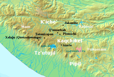
On the eve of the Conquest the highlands of Guatemala
Guatemalan Highlands
The Guatemalan Highlands is an upland region in southern Guatemala, lying between the Sierra Madre de Chiapas to the south and the Petén lowlands to the north....
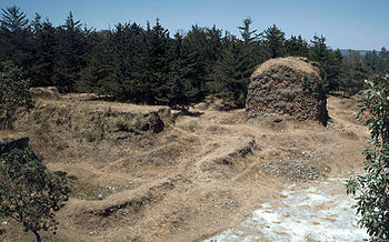
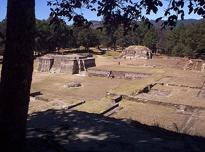
were dominated by several powerful Maya states. In the centuries preceding the arrival of the Spanish the K'iche' had carved out a small empire covering a large part of the western Guatemalan Highlands and the neighbouring Pacific coastal plain. However, in the late 15th century the Kaqchikel allies of the K'iche' rebelled against their former overlords and founded a new kingdom to the southeast with Iximche
Iximche
Iximche is a Pre-Columbian Mesoamerican archaeological site in the western highlands of Guatemala. Iximche was the capital of the Late Postclassic Kaqchikel Maya kingdom from 1470 until its abandonment in 1524. The architecture of the site included a number of pyramid-temples, palaces and two...
as its capital. In the decades prior to the Spanish invasion the Kaqchikel kingdom had been steadily eroding the kingdom of the K'iche'. Other highland groups included the Tz'utujil around Lake Atitlán, the Mam in the western highlands and the Poqomam in the eastern highlands.
The kingdom of the Itza was the most powerful polity in the Petén
Petén Basin
The Petén Basin is a geographical subregion of Mesoamerica, located in the northern portion of the modern-day nation of Guatemala, and essentially contained within the department of El Petén...
lowlands of northern Guatemala, centred upon their capital Nojpetén
Tayasal
Tayasal is a pre-Columbian Maya archaeological site that dates to the Postclassic period. The site is located in the southern Maya lowlands on a small island in Lake Petén Itzá, now part of the Department of Petén in northern Guatemala...
upon Lake Petén Itzá
Lake Petén Itzá
Lake Petén Itzá is a lake in the northern department Petén in Guatemala. It is the second largest lake in Guatemala, the Izabal lake being the largest. It is located around . It has an area of 99 km² some 32 km. long and 5 km wide. Its maximum depth is 160 m...
. The second most important polity was that of their hostile neighbours, the Kowoj
Ko'woj
The Ko'woj were a Maya group and polity, from the Late Postclassic period of Mesoamerican chronology. The Ko'woj claimed to have migrated from Mayapan sometime after the city's collapse in 1441 AD...
. The Kowoj were located to the east of the Itza, around the eastern lakes; Lake Salpetén, Lake Macanché, Lake Yaxhá
Laguna Yaxhá
Laguna Yaxhá is a Guatemalan lake situated in the northern department of El Petén.The ancient Maya City of Yaxhá was built on the shores of Laguna Yaxhá, and the Maya ruins of Topoxté occupy a group of small islands at the western end of the lake....
and Lake Sacnab. Other groups are less well known and their precise territorial extent and political makeup remains obscure, among these are included the Chinamita, the Kejache, the Icaiche, the Lacandon, the Mopan
Mopan people
Mopan are one of the Maya peoples in Belize and Guatemala. Their indigenous language is also called Mopan and is one of the Yucatec Maya languages....
, the Manche Ch'ol and the Yalain. The Kejache occupied an area north of the lake upon the route to Campeche
Campeche
Campeche is one of the 31 states which, with the Federal District, comprise the 32 Federal Entities of Mexico. Located in Southeast Mexico, it is bordered by the states of Yucatán to the north east, Quintana Roo to the east, and Tabasco to the south west...
, while both the Mopan and the Chinamita had their polities in the southeastern Petén. The Manche territory was to the southwest of the Mopan.
Native weapons and tactics
The Spanish described the weapons of war of the Petén Maya as bows and arrows, fire-sharpenedFire Hardening
Fire hardening is the process of removing moisture from wood by slowly and lightly charring it over a fire. This makes a point, like that of a spear, or an edge, like that of a knife, more durable....
poles, flint-headed spears and two-handed sword
Two-handed sword
A two-handed sword, used as a general term, is any large sword designed to be used primarily with two hands:* the European longsword, popular in the Late Middle Ages and Renaissance....
s crafted from strong wood with the blade fashioned from inset obsidian
Obsidian use in Mesoamerica
Obsidian is a naturally formed volcanic glass that was an important part of the material culture of Pre-Columbian Mesoamerica. Obsidian was a highly integrated part of daily and ritual life, and its widespread and varied use may be a significant contributor to Mesoamerica's lack of metallurgy...
, similar to the Aztec macuahuitl
Macuahuitl
The maquahuitl is a weapon shaped like a wooden sword. Its sides are embedded with prismatic blades made from obsidian, a volcanic glass stone frequently used for tool making by the Aztec and other pre-Columbian Mesoamerican cultures...
. Pedro de Alvarado described how the Xinca of the Pacific coast attacked the Spanish with spears, stakes and poisoned arrows.
The Spanish
The conquistadors were all volunteers, the majority of whom did not receive a fixed salary but rather received a portion of the spoils of victory, in the form of precious metalPrecious metal
A precious metal is a rare, naturally occurring metallic chemical element of high economic value.Chemically, the precious metals are less reactive than most elements, have high lustre, are softer or more ductile, and have higher melting points than other metals...
s, land grants and provision of native labour. Many of the Spanish were already experienced soldiers who had previously campaigned in Europe. The initial incursion into Guatemala was led by Pedro de Alvarado who would earn the military title of Adelantado
Adelantado
Adelantado was a military title held by some Spanish conquistadores of the 15th, 16th and 17th centuries.Adelantados were granted directly by the Monarch the right to become governors and justices of a specific region, which they charged with conquering, in exchange for funding and organizing the...
in 1527; he answered to the Spanish crown via Hernán Cortés in Mexico. Other early conquistadors included Pedro de Alvarado's brothers Gómez de Alvarado, Jorge de Alvarado
Jorge de Alvarado
Jorge de Alvarado y Contreras was a Spanish conquistador, brother of the more famous Pedro de Alvarado....
and Gonzalo de Alvarado y Contreras; and his cousins Gonzalo de Alvarado y Chávez, Hernando de Alvarado and Diego de Alvarado. Pedro de Portocarrero was a nobleman who joined the initial invasion. Bernal Díaz del Castillo was a petty nobleman who accompanied Hernán Cortés when he crossed the northern lowlands and also accompanied Pedro de Alvarado's invasion of the highlands.
Spanish weapons and tactics
Spanish weaponry and tactics differed greatly from that of the indigenous peoples of Guatemala. This included the use of crossbowCrossbow
A crossbow is a weapon consisting of a bow mounted on a stock that shoots projectiles, often called bolts or quarrels. The medieval crossbow was called by many names, most of which derived from the word ballista, a torsion engine resembling a crossbow in appearance.Historically, crossbows played a...
s, firearms (including musket
Musket
A musket is a muzzle-loaded, smooth bore long gun, fired from the shoulder. Muskets were designed for use by infantry. A soldier armed with a musket had the designation musketman or musketeer....
s and cannon
Cannon
A cannon is any piece of artillery that uses gunpowder or other usually explosive-based propellents to launch a projectile. Cannon vary in caliber, range, mobility, rate of fire, angle of fire, and firepower; different forms of cannon combine and balance these attributes in varying degrees,...
), war dogs
Dogs in warfare
Dogs in warfare have a long history starting in ancient times. From 'war dogs' trained in combat to their use as scouts, sentries and trackers, their uses have been varied and some continue to exist in modern military usage.-History:...
and war horses
Horses in warfare
The first use of horses in warfare occurred over 5,000 years ago. The earliest evidence of horses ridden in warfare dates from Eurasia between 4000 and 3000 BC. A Sumerian illustration of warfare from 2500 BC depicts some type of equine pulling wagons...
. Among Mesoamerican peoples the capture of prisoners was a priority while to the Spanish such taking of prisoners was a hindrance to outright victory. The inhabitants of Guatemala, for all their sophistication, lacked key elements of Old World technology, such as the use of iron and steel and functional wheels. The use of steel swords was perhaps the greatest technological advantage held by the Spanish, although the deployment of cavalry helped the Spanish rout indigenous armies on occasion.
In Guatemala the Spanish routinely fielded indigenous allies, at first these were Nahua allies brought from the recently conquered Mexico, later on these allies also included Maya. It is estimated that for every Spaniard on the field of battle, there were at least 10 native auxiliaries. Sometimes there were as many as 30 indigenous warriors for every Spaniard, and it was the participation of these Mesoamerican allies that was particularly decisive.
The Spanish engaged in a strategy of concentrating native populations in newly founded Colonial towns, or reducciones
Indian Reductions
Reductions were settlements founded by the Spanish colonizers of the New World with the purpose of assimilating indigenous populations into European culture and religion.Already since the beginning of the Spanish presence in the Americas, the Crown had been concerned...
. Native resistance to the new nucleated settlements took the form of the flight of the indigenous inhabitants into inaccessible regions such as mountains and forests.
Impact of Old World diseases
Epidemics accidentally introduced by the Spanish included smallpox, measlesMeasles
Measles, also known as rubeola or morbilli, is an infection of the respiratory system caused by a virus, specifically a paramyxovirus of the genus Morbillivirus. Morbilliviruses, like other paramyxoviruses, are enveloped, single-stranded, negative-sense RNA viruses...
and influenza
Influenza
Influenza, commonly referred to as the flu, is an infectious disease caused by RNA viruses of the family Orthomyxoviridae , that affects birds and mammals...
. These diseases, together with typhus
Typhus
Epidemic typhus is a form of typhus so named because the disease often causes epidemics following wars and natural disasters...
and yellow fever
Yellow fever
Yellow fever is an acute viral hemorrhagic disease. The virus is a 40 to 50 nm enveloped RNA virus with positive sense of the Flaviviridae family....
, had a major impact on Maya populations. The Old World
Old World
The Old World consists of those parts of the world known to classical antiquity and the European Middle Ages. It is used in the context of, and contrast with, the "New World" ....
diseases brought with the Spanish and against which the indigenous New World
New World
The New World is one of the names used for the Western Hemisphere, specifically America and sometimes Oceania . The term originated in the late 15th century, when America had been recently discovered by European explorers, expanding the geographical horizon of the people of the European middle...
peoples had no resistance were a deciding factor in the Conquest, with the diseases crippling armies and decimating populations before battles were even fought.
In 1519 and 1520, prior to the arrival of the Spanish in the region, a number of epidemics swept through southern Guatemala. At the same time as the Spanish were occupied with the overthrow of the Aztec empire a terrible plague struck the Kaqchikel capital of Iximche, and the city of Q'umarkaj, capital of the K'iche', may also have suffered from the same epidemic. In 1666 pestilence or murine typhus
Murine typhus
Murine typhus is a form of typhus transmitted by fleas , usually on rats. Murine typhus is an under-recognized entity, as it is often confused with viral illnesses...
swept through what is now the department of Huehuetenango. Smallpox was reported in San Pedro Saloma, in 1795. At the time of the fall of Nojpetén in 1697, there are estimated to have been 60,000 Maya living around Lake Petén Itzá, including a large number of refugees from other areas. It is estimated that 88% of these died during the first ten years of colonial rule due to a combination of disease and war.
Timeline of the Conquest
| Date | Event | Modern department (or Mexican state) |
|---|---|---|
| 1521 | Conquest of Tenochtitlan | Mexico |
| 1522 | Spanish allies scout Soconusco and receive delegations from the K'iche' and Kaqchikel | Chiapas, Mexico |
| 1523 | Pedro de Alvarado arrives in Soconusco | Chiapas, Mexico |
| February - March 1524 | Spanish defeat the K'iche' | Retalhuleu, Suchitepéquez, Quetzaltenango, Totonicapán and El Quiché |
| 8 February 1524 | Battle of Zapotitlán, Spanish victory over the K'iche' | Suchitepéquez |
| 12 February 1524 | 1st battle of Quetzaltenango results in the death of the K'iche' lord Tecun Uman | Quetzaltenango |
| 18 February 1524 | 2nd battle of Quetzaltenango | Quetzaltenango |
| March 1524 | Spanish under Pedro de Alvarado raze Q'umarkaj, capital of the K'iche' | El Quiché |
| 14 April 1524 | Spanish enter Iximche and ally themselves with the Kaqchikel | Chimaltenango |
| 18 April 1524 | Spanish defeat the Tz'utujil in battle on the shores of Lake Atitlán | Sololá |
| 9 May 1524 | Pedro de Alvarado defeats the Pipil of Panacal or Panacaltepeque near Izcuintepeque | Escuintla |
| 26 May 1524 | Pedro de Alvarado defeats the Xinca of Atiquipaque | Santa Rosa |
| 27 July 1524 | Iximche declared first colonial capital of Guatemala | Chimaltenango |
| 28 August 1524 | Kaqchikel abandon Iximche and break alliance | Chimaltenango |
| 7 September 1524 | Spanish declare war on the Kaqchikel | Chimaltenango |
| 1525 | The Poqomam capital falls to Pedro de Alvarado | Guatemala |
| 13 March 1525 | Hernán Cortés arrives at Lake Petén Itzá | Petén |
| October 1525 | Zaculeu, capital of the Mam, surrenders to Gonzalo de Alvarado y Chávez after a lengthy siege | Huehuetenango |
| 1526 | Chajoma rebel against the Spanish | Guatemala |
| 9 February 1526 | Spanish deserters burn Iximche | Chimaltenango |
| 1527 | Spanish abandon their capital at Tecpán Guatemala | Chimaltenango |
| 1529 | San Mateo Ixtatán given in encomienda to Gonzalo de Ovalle | Huehuetengo |
| 9 May 1530 | Kaqchikel surrender to the Spanish | Sacatepéquez |
| 1549 | First reductions of the Chuj and Q'anjob'al | Huehuetenango |
| 1618 | Franciscan missionaries arrive at Nojpetén, capital of the Itzá | Petén |
| 1619 | Further missionary expeditions to Nojpetén | Petén |
| 1684 | Reduction of San Mateo Ixtatán and Santa Eulalia | Huehuetenango |
| 29 January 1686 | Melchor Rodríguez Mazariegos leaves Huehuetenango, leading an expedition against the Lacandón | Huehuetenango |
| 1695 | Franciscan friar Andrés de Avendaño attempts to convert the Itzá | Petén |
| 28 February 1695 | Spanish expeditions leave simultaneously from Cobán, San Mateo Ixtatán and Ocosingo against the Lacandón | Alta Verapaz, Huehuetenango and Chiapas |
| 1696 | Andrés de Avendaño forced to flee Nojpetén | Petén |
| 13 March 1697 | Nojpetén falls to the Spanish after a fierce battle | Petén |
Conquest of the highlands
Aztec
The Aztec people were certain ethnic groups of central Mexico, particularly those groups who spoke the Nahuatl language and who dominated large parts of Mesoamerica in the 14th, 15th and 16th centuries, a period referred to as the late post-classic period in Mesoamerican chronology.Aztec is the...
s, fell to the Spanish in 1521, the Kaqchikel Maya of Iximche sent envoys to Hernán Cortés
Hernán Cortés
Hernán Cortés de Monroy y Pizarro, 1st Marquis of the Valley of Oaxaca was a Spanish Conquistador who led an expedition that caused the fall of the Aztec Empire and brought large portions of mainland Mexico under the rule of the King of Castile in the early 16th century...
to declare their allegiance to the new ruler of Mexico, and the K'iche' Maya of Q'umarkaj may also have sent a delegation. In 1522 Cortés sent Mexican allies to scout the Soconusco
Soconusco
Soconusco is a region of the Mexican state of Chiapas, located in the extreme south of the state and separated from Guatemala by the Suchiate River. It is a region of rich lowlands and foothills. The economic center is Tapachula. Soconusco consists of 16 municipalities.The name comes from the...
region of lowland Chiapas
Chiapas
Chiapas officially Estado Libre y Soberano de Chiapas is one of the 31 states that, with the Federal District, comprise the 32 Federal Entities of Mexico. It is divided in 118 municipalities and its capital city is Tuxtla Gutierrez. Other important cites in Chiapas include San Cristóbal de las...
, where they met new delegations from both Iximche and Q'umarkaj at Tuxpán, with both of the powerful highland Maya kingdoms declaring their loyalty to the king of Spain
Charles V, Holy Roman Emperor
Charles V was ruler of the Holy Roman Empire from 1519 and, as Charles I, of the Spanish Empire from 1516 until his voluntary retirement and abdication in favor of his younger brother Ferdinand I and his son Philip II in 1556.As...
. Cortés' allies in Soconusco soon informed him that the K'iche' and the Kaqchikel were not loyal, instead harassing the allies of Spain in the region. Due to this Cortés despatched Pedro de Alvarado
Pedro de Alvarado
Pedro de Alvarado y Contreras was a Spanish conquistador and governor of Guatemala. He participated in the conquest of Cuba, in Juan de Grijalva's exploration of the coasts of Yucatan and the Gulf of Mexico, and in the conquest of Mexico led by Hernan Cortes...
with 180 cavalry, 300 infantry, crossbows, muskets, 4 cannons, large amounts of ammunition and gunpowder, and allied Mexican warriors
Tlaxcaltec
The Tlaxcalteca were an indigenous group of Nahua ethnicity that inhabited the Kingdom of Tlaxcala located in what is now the Mexican state of Tlaxcala.-Pre-hispanic history:...
. They arrived in Soconusco in 1523. Pedro de Alvarado was infamous for the massacre of Aztec nobles in Tenochtitlan and, according to Bartolomé de las Casas
Bartolomé de Las Casas
Bartolomé de las Casas O.P. was a 16th-century Spanish historian, social reformer and Dominican friar. He became the first resident Bishop of Chiapas, and the first officially appointed "Protector of the Indians"...
, he committed further atrocities in the conquest of the Maya kingdoms in Guatemala.
Subjugation of the K'iche'
Pedro de Alvarado advanced with his army along the PacificPacific Ocean
The Pacific Ocean is the largest of the Earth's oceanic divisions. It extends from the Arctic in the north to the Southern Ocean in the south, bounded by Asia and Australia in the west, and the Americas in the east.At 165.2 million square kilometres in area, this largest division of the World...
coast without opposition until they reached the Samalá River
Samalá River
The Samalá is a river in Southwest Guatemala. Its sources are located in the Sierra Madre range, in the departments of Totonicapán and Quetzaltenango...
in western Guatemala. This region formed a part of the K'iche' kingdom
K'iche' Kingdom of Q'umarkaj
The K'iche' Kingdom of Q'umarkaj was a state in the highlands of modern day Guatemala which was founded by the K'iche' Maya in the thirteenth century, and which expanded through the fifteenth century until it was conquered by Spanish and Nahua forces led by Pedro de Alvarado in 1524.The K'iche'...
and a K'iche' army tried to prevent the Spanish from crossing the river. Their resistance failed and the conquistadors crossed the river and ransacked nearby settlements in order to terrorise the K'iche' resistance. On 8 February 1524, after forcing their way across the river, Alvarado's army fought a battle at Xetulul, called Zapotitlán by his Mexican allies (modern San Francisco Zapotitlán
San Francisco Zapotitlán
San Francisco Zapotitlán is a municipality in the Suchitepéquez department of Guatemala....
). Although suffering many injuries from defending K'iche' archers, the Spanish and their allies stormed the town and set camp in the marketplace. Alvarado then turned to head upriver into the Sierra Madre mountains
Sierra Madre de Chiapas
Sierra Madre is a mountain range which runs northwest-southeast from the state of Chiapas in Mexico across Guatemala and into El Salvador and Honduras. Most of the volcanoes of Guatemala are a part of this range.A narrow coastal plain lies south the range, between the Sierra Madre and the Pacific...
towards the K'iche' heartlands, crossing the pass into the fertile valley of Quetzaltenango
Quetzaltenango
Quetzaltenango, also commonly known by its indigenous name, Xelajú , or more commonly, Xela , is the second largest city of Guatemala. It is both the capital of Quetzaltenango Department and the municipal seat of Quetzaltenango municipality....
. On 12 February 1524 Alvarado's Mexican allies were ambushed in the pass and driven back by the K'iche' warriors but the Spanish cavalry charge that followed was a shock for the K'iche' who had never seen horses before. The cavalry scattered the K'iche' and the army crossed to the city of Xelaju, modern Quetzaltenango, to find it deserted by its inhabitants. Although the common view is that the K'iche' prince Tecun Uman
Tecún Umán
Tecún Umán was the last ruler and king of the K'iche' Maya people, in the highlands of what is now Guatemala...
died in the later battle near Olintepeque
Olintepeque
Olintepeque is a municipality in the Quetzaltenango department of Guatemala. It is located on the Xequijel River.Olintepeque is known for being the place where the legendary K'iche' king Tecún Umán died in single combat with the Spanish conquistador, Pedro de Alvarado on February 18, 1524...
, the Spanish accounts are clear that at least one and possibly two of the lords of Q'umarkaj died in the fierce battles upon the initial approach to Quetzaltenango. The death of Tecun Uman is said to have taken place in the battle of El Pinar, and local tradition has his death taking place upon the Llanos de Urbina (Plains of Urbina), upon the approach to Quetzaltenango near the modern village of Cantel
Cantel, Guatemala
Cantel is a small municipality in the Quetzaltenango Department in Guatemala, east from the city of Quetzaltenango with an area of 22 km2. The village of Cantel is situated at 2,370 m altitude. The population is 32,221 people....
. Pedro de Alvardo, in his 3rd letter to Hernán Cortés, describes the death of one of the four lords of Q'umarkaj upon the approach to Quetzaltenango. The letter was dated 11 April 1524 and was written during his stay at Q'umarkaj. Almost a week later, on 18 February 1524, a K'iche' army confronted the Spanish army in the Quetzaltenango valley where they were comprehensively defeated, with many K'iche' nobles among the dead. Such were the numbers of K'iche' dead that Olintepeque was given the new name Xequiquel, roughly meaning "bathed in blood". This battle exhausted the K'iche' militarily and they asked for peace and offered tribute, inviting Pedro de Alvarado into their capital Q'umarkaj, which was known as Tecpan Utatlan to the Nahuatl-speaking allies of the Spanish. Alvarado was deeply suspicious of the K'iche' intentions but accepted the offer and marched to Q'umarkaj with his army.
Quetzaltenango
Quetzaltenango, also commonly known by its indigenous name, Xelajú , or more commonly, Xela , is the second largest city of Guatemala. It is both the capital of Quetzaltenango Department and the municipal seat of Quetzaltenango municipality....
valley. Alvarado feared that a trap had been laid for him by the K'iche' lords but entered the city anyway. However, he encamped on the plain outside the city rather than accepting lodgings inside. Fearing the great number of K'iche' warriors gathered outside the city and that his cavalry would not be able to maneouvre in the narrow streets of Q'umarkaj, he invited the highest lords of the city, Oxib-Keh (the ajpop, or king) and Beleheb-Tzy (the ajpop k'amha, or king elect) to visit him in his camp. As soon as they did so, he seized them and kept them as prisoners in his camp. The K'iche' warriors, seeing their lords taken prisoner, attacked the Spaniards' indigenous allies and managed to kill one of the Spanish soldiers. At this point Alvarado decided to have the captured K'iche' lords burnt to death, he then proceeded to burn the entire city. With the destruction of Q'umarkaj and the execution of its rulers, Pedro de Alvarado sent messages to Iximche, capital of the Kaqchikel, proposing an alliance against the remaining K'iche' resistance. Alvarado wrote that they sent 4000 warriors to assist him, although the Kaqchikel recorded that they only sent 400.
Kaqchikel alliance
When Spanish conquistador Pedro de Alvarado arrived in what is now Guatemala in 1524, 3 years after the conquest of the Aztecs, he found the highland Maya kingdoms weakened by twenty years of warfare and swept by the first European plagues. In the period of February to March 1524 he fought and completely defeated the K'iche', razed Q'umarkaj and executed the K'iche' kings. The Spanish were invited into Iximche on 14 April 1524 and were well received by the lords Belehe Qat and Cahi Imox.Recinos places all these dates 2 days earlier (e.g. the Spanish arrival at Iximche on 12 April rather than 14 April) based on vague dating in Spanish primary records. Schele and Fahsen calculated all dates on the more securely dated Kaqchikel annals, where equivalent dates are often given in both the Kaqchikel and Spanish calendars. The Schele and Fahsen dates are used in this section. Schele & Mathews 1999, p.386.n15. The Kaqchikel kings provided native soldiers to assist the conquistadors against continuing K'iche' resistance and to help with the defeat of the neighbouring Tz'utuhil kingdom. The Spanish only stayed briefly in Iximche before continuing through Atitlán, EscuintlaEscuintla
Escuintla is a city in south central Guatemala. It is the capital of the Escuintla Department and the administrative seat of Escuintla Municipality....
and Cuscatlán
Cuscatlán Department
Cuscatlán is a department of El Salvador, located in the center of the country. With a surface area of , it is El Salvador's smallest department. It is inhabited by over 200,000 people. Cuscatlán or Cuzcatlán was the name the original inhabitants of the Western part of the country gave to most of...
. The Spanish returned to the Kaqchikel capital on 23 July 1524 and on 27 July (1 Q'at in the Kaqchikel calendar) Pedro de Alvarado declared Iximche as the first capital of Guatemala, Santiago de los Caballeros de Guatemala ("St. James of the Knights of Guatemala"). Iximche was called Guatemala by the Spanish, from the Nahuatl Quauhtemallan meaning "forested land". Since the Spanish conquistadors founded their first capital at Iximche, they took the name of the city used by their Nahuatl-speaking Mexican allies and applied it to the new Spanish city and, by extension, to the kingdom
Captaincy General of Guatemala
The Captaincy General of Guatemala , also known as the Kingdom of Guatemala , was an administrative division in Spanish America which covered much of Central America, including what are now the nations of Costa Rica, Nicaragua, Honduras, El Salvador and Guatemala, and the Mexican state of Chiapas...
. From this comes the modern name of the country.
Conquest of the Tz'utujil
The Kaqchikel appear to have entered into an alliance with the Spanish in order to defeat their enemies, the Tz'utujil, whose capital was Tecpan Atitlan. Pedro de Alvarado sent two Kaqchikel messengers to Tecpan Atitlan at the request of the Kaqchikel lords; both messengers were killed by the Tz'utujil. When news of the killing of the messengers reached the Spanish at Iximche, the conquistadors marched against the Tz'utujil with their Kaqchikel allies. Pedro de Alvarado left Iximche just 5 days after he had arrived there, with 60 cavalry, 150 Spanish infantry and an unspecified number of Kaqchikel warriors. The Spanish and their allies arrived at the lakeshore after a day's hard march, without encountering any opposition. Seeing the lack of resistance, Alvarado rode ahead with 30 cavalry along the lake shore. Opposite a populated island the Spanish at last encountered hostile Tz'utujil warriors and charged among them, scattering them and pursuing them to a narrow causeway across which the surviving Tz'utujil fled. The causeway was too narrow for the horses, so the conquistadors dismounted and crossed to the island before the inhabitants could break the bridges. The rest of Alvarado's army soon reinforced his party and they successfully stormed the island. The surviving Tz'utujil fled into the lake and swam to safety on another island. The Spanish could not pursue the survivors further because 300 canoes sent by the Kaqchikels had not yet arrived. This battle took place on 18 April.The following day the Spanish entered Tecpan Atitlan but found it deserted. Pedro de Alvarado camped in the centre of the city and sent out scouts to find the enemy. They managed to catch some locals and used them to send messages to the Tz'utujil lords, ordering them to submit to the king of Spain. The Tz'utujil leaders responded by surrendering to Pedro de Alvarado and swearing loyalty to Spain, at which point Alvarado considered them pacified and returned to Iximche. Three days after Pedro de Alvarado returned to Iximche, the lords of the Tz'utujil arrived there to pleadge their loyalty and offer tribute to the conquistadors. A short time afterwards a number of lords arrived from the Pacific lowlands to swear allegiance to the king of Spain, although Alvarado did not name them in his letters; they confirmed Kaqchikel reports that further out on the Pacific plain was the kingdom called Izcuintepeque in Nahuatl, or Panatacat in Kaqchikel
Kaqchikel language
The Kaqchikel, or Kaqchiquel, language is an indigenous Mesoamerican language and a member of the Quichean–Mamean branch of the Mayan languages family. It is spoken by the indigenous Kaqchikel people in central Guatemala...
, whose inhabitants were warlike and hostile towards their neighbours.
Kaqchikel rebellion
Peso
The word peso was the name of a coin that originated in Spain and became of immense importance internationally...
s. A Kaqchikel priest foretold that the Kaqchikel gods would destroy the Spanish and the Kaqchikel people abandoned their city and fled to the forests and hills on 28 August 1524 (7 Ahmak in the Kaqchikel calendar). Ten days later the Spanish declared war on the Kaqchikel. A couple of years later, on 9 February 1526, a group of sixteen Spanish deserters burnt the palace of the Ahpo Xahil, sacked the temples and kidnapped a priest, acts that the Kaqchikel blamed on Pedro de Alvarado.Recinos 1998, p.19. gives sixty deserters. Conquistador Bernal Díaz del Castillo
Bernal Díaz del Castillo
Bernal Díaz del Castillo was a conquistador, who wrote an eyewitness account of the conquest of Mexico by the Spaniards for Hernán Cortés, himself serving as a rodelero under Cortés.-Early life:...
recounted how in 1526 he returned to Iximche and spent the night in the "old city of Guatemala" together with Luis Marín and other members of Hernán Cortés
Hernán Cortés
Hernán Cortés de Monroy y Pizarro, 1st Marquis of the Valley of Oaxaca was a Spanish Conquistador who led an expedition that caused the fall of the Aztec Empire and brought large portions of mainland Mexico under the rule of the King of Castile in the early 16th century...
's expedition to Honduras. He reported that the houses of the city were still in excellent condition, his account was the last description of the city while it was still inhabitable.
The Spanish founded a new town at nearby Tecpán Guatemala
Tecpán Guatemala
Tecpán Guatemala is a municipality in the department of Chimaltenango, in Guatemala, on the Inter-American Highway CA-1.The climate is generally cold...
, with Tecpán being Nahuatl for "palace", so the name of the new town translated as "the palace among the trees". The inhabitants of Iximche were dispersed, with some being moved to Tecpán, others to Sololá
Sololá
Sololá is a city in Guatemala. It is the capital of the department of Sololá and the administrative seat of Sololá municipality.The name is a hispanicized form of its pre-Columbian name, one spelling variant of which is T'zolojy'a...
and to other towns around Lake Atitlán.
The Spaniards abandoned Tecpán in 1527, due to the continuous Kaqchikel attacks, and moved to the Almolonga Valley to the east, refounding their capital on the site of today's San Miguel Escobar district of Ciudad Vieja
Ciudad Vieja
Ciudad Vieja is a municipality in the Guatemalan department of Sacatepéquez. According to the 2002 Guatemalan Census, the municipality has a total of 25,696 people.Ciudad Vieja was the second colonial capital of the country.- History :...
, near Antigua Guatemala
Antigua Guatemala
Antigua Guatemala is a city in the central highlands of Guatemala famous for its well-preserved Spanish Mudéjar-influenced Baroque architecture as well as a number of spectacular ruins of colonial churches...
.
The Kaqchikel kept up resistance against the Spanish for a number of years but on 9 May 1530 the two kings of the most important clans returned from the wilds. A day later they were joined by many nobles and their families and many more people came with them to surrender at the new Spanish capital at Ciudad Vieja.
Siege of Zaculeu
Although a state of hostilities existed between the Mam and the K'iche' of Q'umarkaj after the rebellion of the Kaqchikel against their K'iche' allies, when the conquistadors arrived there was a shift in the political landscape. Pedro de Alvarado described how the Mam king Kayb'il B'alamKayb'il B'alam
Kayb'il B'alam was a 16th-century leader of the Mam people Maya kingdom in the western highlands of Guatemala. During the time of the Spanish invasion, the Mam population was mainly situated in Xinabahul...
was received with great honour in Q'umarkaj while he was there.
At the time of the Conquest, the main Mam population was situated in Xinabahul (also spelled Chinabjul), now the city of Huehuetenango
Huehuetenango
Huehuetenango is a city and a municipality in the highlands of western Guatemala. It is also the capital of the department of Huehuetenango. The municipality's population was over 81,000 people in 2002...
, but Zaculeu's fortifications led to its use as a refuge during the conquest. The refuge was attacked by Gonzalo de Alvarado y Chávez
Gonzalo de Alvarado
Gonzalo de Alvarado was the name of two Spanish conquistadors, both related to Pedro de Alvarado and participating in the conquest of Mexico and Central America...
, cousin of conquistador Pedro de Alvarado, in 1525, with 120 soldiers, and some 2,000 Mexican and K'iche' allies. The city was defended by Kayb'il B'alam commanding some 5,000 people (the chronicles are not clear if this is the number of soldiers or the total population of Zaculeu).
After a siege lasting several months the Mam were reduced to starvation. Kayb'il B'alam finally surrendered the city to the Spanish in October of 1525. When the Spanish entered the city they found 1,800 dead Indians, with the survivors eating the corpses of the dead. After this Zaculeu was abandoned, and the new city of Huehuetenango established some 5 kilometres (3.1 mi) away.
Conquest of the Poqomam
In 1525 Pedro de Alvarado sent a small company to conquer Mixco ViejoMixco Viejo
Mixco Viejo is an archaeological site in the north east of the Chimaltenango department of Guatemala, some 50 km to the north of Guatemala City and 4km from the junction of the rivers Pixcaya and Motagua...
, the capital of the Poqomam.The location of the historical city of Mixco Viejo has been the source of some confusion. The archaeological site now known as Mixco Viejo has been proven to be Jilotepeque Viejo, the capital of the Chajoma. The Mixco Viejo of colonial records has now been associated with the archaeological site of Chinautla Viejo, much closer to modern Mixco. Carmack 2001a, pp.151, 158. At the Spanish approach, the inhabitants remained enclosed in the fortified city. The Spanish attempted an approach from the west through a narrow pass but were forced back with heavy losses. Alvarado himself launched the second assault with 200 Tlaxcalan allies but was also beaten back. The Poqomam then received reinforcements, possibly from Chinautla, and the two armies clashed on open ground outside of the city. The battle was chaotic and lasted for most of the day but was finally decided by the Spanish cavalry, forcing the Poqomam reinforcements to withdraw. The leaders of the reinforcements surrendered to the Spanish three days after their retreat and revealed that the city had a secret entrance in the form of a cave leading up from a nearby river, allowing the inhabitants to come and go.
Armed with the knowledge gained from their prisoners, Alvarado sent 40 men to cover the exit from the cave and launched another assault along the ravine from the west, in single file owing to its narrowness, with crossbowmen alternating with soldiers bearing muskets, each with a companion sheltering him from arrows and stones with a shield. This tactic allowed the Spanish to break through the pass and storm the entrance of the city. The Poqomam warriors fell back in disorder in a chaotic retreat through the city, and were hunted down by the victorious conquistadors and their allies. Those who managed to retreat down the neighbouring valley were ambushed by Spanish cavalry who had been posted to block the exit from the cave, the survivors were captured and brought back to the city. The siege had lasted more than a month and due to the defensive strength of the city, Alvarado ordered it to be burned and moved the inhabitants to the new colonial village of Mixco
Mixco
Mixco is a municipality in the Guatemala department of Guatemala.Located next to the main Guatemala City municipality, over time it has become part of the Guatemala City Metropolitan Area. Most of Mixco is separated from the city by canyons, for which a multitude of bridges have been created. ...
.
Resettlement of the Chajoma
There are no direct sources describing the conquest of the Chajoma by the Spanish but it appears to have been a drawn-out campaign rather than a rapid victory. The only description of the conquest of the Chajoma is a secondary account appearing in the work of Francisco Antonio de Fuentes y GuzmánFrancisco Antonio de Fuentes y Guzmán
Francisco Antonio de Fuentes y Guzmán was a Guatemalan historian and poet. His only surviving work is La Recordación Florida.-Biography:...
in the 17th century, long after the event. After the Conquest, the inhabitants of the eastern part of the kingdom were relocated by the conquerors to San Pedro Sacatepéquez
San Pedro Sacatepéquez, Guatemala
San Pedro Sacatepéquez is a municipality in the Guatemala department of Guatemala. According to the 1998 edition of the The Columbia Gazetteer of the World, its elevation is 6,890 ft and it is a market center. Its economy is based on manufacturing, including tile making and textiles, and...
, including some of the inhabitants of the archaeological site now known as Mixco Viejo
Mixco Viejo
Mixco Viejo is an archaeological site in the north east of the Chimaltenango department of Guatemala, some 50 km to the north of Guatemala City and 4km from the junction of the rivers Pixcaya and Motagua...
. The rest of the population of Mixco Viejo, together with the inhabitants of the western part of the kingdom, were moved to San Martín Jilotepeque
San Martín Jilotepeque
San Martín Jilotepeque is a municipality in the Chimaltenango department of Guatemala.-See also:Chajoma...
.
The Chajoma rebelled against the Spanish in 1526, fighting a battle at Ukub'il, an unidentified site somewhere near the modern towns of San Juan Sacatepéquez
San Juan Sacatepéquez
San Juan Sacatepéquez is a municipality in the Guatemala department of Guatemala, northwest of Guatemala City. According to the 2002 census, it had a population of 81,584. The city is known for flower-growing and wooden furniture.-See also:*Chajoma...
and San Pedro Sacatepéquez.
In the colonial period, most of the surviving Chajoma were forcibly settled in the towns of San Juan Sacatepéquez, San Pedro Sacatepéquez and San Martín Jilotepeque as a result of the Spanish policy of congregaciones
Indian Reductions
Reductions were settlements founded by the Spanish colonizers of the New World with the purpose of assimilating indigenous populations into European culture and religion.Already since the beginning of the Spanish presence in the Americas, the Crown had been concerned...
, with the people being moved to whichever of these three towns was closest to their pre-Conquest land holdings. Some Iximche Kaqchikels seem also to have been relocated to the same towns with them. After their relocation to the new towns, some of the Chajoma drifted back to their pre-Conquest centres, creating informal settlements and provoking hostilities with the Poqomam of Mixco and Chinautla along the former border between the pre-Columbian kingdoms. Some of these settlements eventually received official recognition, such as San Raimundo near Sacul.
Campaigns in the Cuchumatanes
In the ten years after the fall of Zaculeu various Spanish expeditions crossed into the Sierra de los CuchumatanesSierra de los Cuchumatanes
The Sierra de los Cuchumatanes is the highest non-volcanic mountain range in Central America. Its elevations range from 500 m to over 3,800 m, and it covers a total area of ±16,350 km². With an area of 1,500 km² situated above 3,000 m, it is also the most extensive highland region in Central...
and engaged in the gradual and complex conquest of the Chuj
Chuj people
The Chuj are a Maya people in Guatemala and Mexico. Their indigenous language is also called Chuj and belongs to the Q'anjobalan–Chujean family of Mayan languages. In Guatemala, most Chuj live in the department of Huehuetenango in the municipalities of San Mateo Ixtatán and San Sebastián Coatán....
and Q'anjob'al
Q'anjob'al people
The Q'anjob'al are a Maya people in Guatemala. Their indigenous language is also called Q'anjob'al....
. The Spanish were attracted to the region in the hope of extracting gold, silver and other riches from the mountains but their remoteness, the difficult terrain and relatively low population made their conquest and exploitation extremely difficult.
In 1529, four years after the conquest of Huehuetenango, the Chuj city of San Mateo Ixtatán
San Mateo Ixtatán
San Mateo Ixtatán is a municipality in the Guatemalan department of Huehuetenango. It is situated at above sea level in the Cuchumatanes mountain range and covers of terrain. It has a cold climate and is located in a cloud forest. The temperature fluctuates between . The coldest months are from...
(then known by the name of Ystapalapán) was given in encomienda
Encomienda
The encomienda was a system that was employed mainly by the Spanish crown during the colonization of the Americas to regulate Native American labor....
to the conquistador Gonzalo de Ovalle, a companion of Pedro de Alvarado, together with Santa Eulalia
Santa Eulalia, Huehuetenango
Santa Eulalia also known as Jolom Konob is a municipality located in the north-east of the department of Huehuetenango, Guatemala, Central America. This town is rich in culture and traditions...
and Jacaltenango
Jacaltenango
Jacaltenango is a town situated in the Western Highlands of Guatemala. It is located in a valley surrounded by the Sierra Madre Mountains.Jacaltenango serves as the municipal seat for the surrounding municipality of the same name....
. In 1549, the first reduction
Indian Reductions
Reductions were settlements founded by the Spanish colonizers of the New World with the purpose of assimilating indigenous populations into European culture and religion.Already since the beginning of the Spanish presence in the Americas, the Crown had been concerned...
(reducción in Spanish) of San Mateo Ixtatán took place, overseen by Dominican
Dominican Order
The Order of Preachers , after the 15th century more commonly known as the Dominican Order or Dominicans, is a Catholic religious order founded by Saint Dominic and approved by Pope Honorius III on 22 December 1216 in France...
missionaries, in the same year the Q'anjob'al reducción settlement of Santa Eulalia was founded. Further Q'anjob'al reducciones were in place at San Pedro Soloma
San Pedro Soloma
San Pedro Soloma or Soloma is a municipality in the Guatemalan department of Huehuetenango. It is situated in the Sierra de los Cuchumatanes at 2,300 m above sea level. The municipality covers a total area of 264 km2 with elevations ranging from 1,900 m to 3,500 m...
, San Juan Ixcoy
San Juan Ixcoy
San Juan Ixcoy is a municipality in the Guatemalan department of Huehuetenango. The municipality covers an area of 224 km² and is formed by the town of San Juan Ixcoy, 11 villages and 33 caserios...
and San Miguel Acatán
San Miguel Acatán
San Miguel Acatán is a municipality in the Guatemalan department of Huehuetenango. The Mayan language of Akateko is spoken here....
by 1560. Q'anjob'al resistance was largely passive, based upon withdrawal to the inaccessible mountains and forests from the Spanish reducciones. In 1586 the Mercedarian
Order of the Blessed Virgin Mary of Mercy
The Royal, Celestial and Military Order of Our Lady of Mercy and the Redemption of the Captives also known as Our Lady of Ransom is a Roman Catholic religious order established in 1218 by St...
Order built the first church in Santa Eulalia. The Chuj of San Mateo Ixtatán remained rebellious and resisted Spanish control for longer than their highland neighbours, resistance that was possible due to their alliance with the lowland Lacandon to the north. The continued resistance was so determined that the Chuj remained pacified only while the immediate effects of the Spanish expeditions lasted.
In the late 17th century, the Spanish misssionary Fray
Friar
A friar is a member of one of the mendicant orders.-Friars and monks:...
Alonso De León reported that about eighty families in San Mateo Ixtatán did not pay tribute to the Spanish Crown or attend the Roman Catholic mass. He described the inhabitants as quarrelsome and complained that they had built a pagan shrine in the hills among the ruins of precolumbian temples, where they burnt incense and offerings and sacrificed turkeys. He reported that every March they built bonfires around wooden crosses about two leagues
League (unit)
A league is a unit of length . It was long common in Europe and Latin America, but it is no longer an official unit in any nation. The league originally referred to the distance a person or a horse could walk in an hour...
from the town and set them on fire. Fray Alonso de León informed the colonial authorities that the practices of the natives were such that they were Christian
Christian
A Christian is a person who adheres to Christianity, an Abrahamic, monotheistic religion based on the life and teachings of Jesus of Nazareth as recorded in the Canonical gospels and the letters of the New Testament...
in name only. Eventually, Fray Alsonso De León was chased out of San Mateo Ixtatán by the locals.
In 1684, a council led by Enrique Enriquez de Guzmán, the then governor of Guatemala, decided upon the reduction of San Mateo Ixtatán and nearby Santa Eulalia, both within the colonial administrative district of the Corregimiento
Corregidor (position)
A corregidor was a local, administrative and judicial position in Spain and its empire. He was the highest authority of a Corregimiento. In the Americas a corregidor was often called an alcalde mayor. They began to be appointed in fourteenth century Castile and the institution was definitively...
of Huehuetenango.
On 29 January 1686, captain Melchor Rodríguez Mazariegos, under orders of the governor, left Huehuetenango for San Mateo Ixtatán, where he recruited indigenous warriors from the nearby villages, with 61 from San Mateo itself. It was believed by the Spanish colonial authorities that the inhabitants of San Mateo Ixtatán were friendly towards the still unconquered and fiercely hostile inhabitants of the Lacandon region
Lacandon Jungle
The Lacandon Jungle is an area of rainforest which stretches from Chiapas, Mexico into Guatemala and into the southern part of the Yucatán Peninsula. The heart of this rainforest is located in the Montes Azules Biosphere Reserve in Chiapas near the border with Guatemala in the Montañas del Oriente...
, which included parts of what is now the Mexican
Mexico
The United Mexican States , commonly known as Mexico , is a federal constitutional republic in North America. It is bordered on the north by the United States; on the south and west by the Pacific Ocean; on the southeast by Guatemala, Belize, and the Caribbean Sea; and on the east by the Gulf of...
state of Chiapas
Chiapas
Chiapas officially Estado Libre y Soberano de Chiapas is one of the 31 states that, with the Federal District, comprise the 32 Federal Entities of Mexico. It is divided in 118 municipalities and its capital city is Tuxtla Gutierrez. Other important cites in Chiapas include San Cristóbal de las...
and the western part of the Petén Basin
Petén Basin
The Petén Basin is a geographical subregion of Mesoamerica, located in the northern portion of the modern-day nation of Guatemala, and essentially contained within the department of El Petén...
. In order to prevent news of the Spanish advance reaching the inhabitants of the Lacandon area, the governor ordered the capture of three community leaders of San Mateo, named as Cristóbal Domingo, Alonso Delgado and Gaspar Jorge, and had them sent under guard to be imprisoned in Huehuetenango. The governor himself arrived in San Mateo Ixtatán on 3 February, where captain Melchor Rodríguez Mazariegos was already awaiting him. The governor ordered the captain to remain in the village to use it as a base of operations for penetrating the Lacandon region. The Spanish missionaries Fray Diego de Rivas and Fray Pedro de la Concepción also remained in the town. After this, governor Enrique Enriquez de Guzmán left San Mateo Ixtatán for Comitán in Chiapas, to enter the Lacandon region via Ocosingo
Ocosingo
Ocosingo is a city and its surrounding municipality of the same name in the Mexican state of Chiapas. The municipality borders the Usumacinta River along a portion where the river forms the international border with Guatemala. The city had a 2005 census population of 35,065 inhabitants, and serves...
.
In 1695, a three-way invasion of the Lacandon was launched simultaneously from San Mateo Ixtatán, Cobán
Cobán
The city of Cobán is the capital of the department of Alta Verapaz in central Guatemala. It also serves as the administrative center for the surrounding Cobán municipality. It is located 219 km from Guatemala City....
and Ocosingo. Captain Melchor Rodriguez Mazariegos accompanied by Fray Diego de Rivas and 6 more missionaries together with 50 Spanish soldiers left Huehuetenango for San Mateo Ixtatán, managing to recruit 200 indigenous Maya warriors on the way; from Santa Eulalia, San Juan Solomá and San Mateo itself. They followed the same route used in 1686. On 28 February 1695, all three groups left their respective bases of operations to conquer the Lacandon. The San Mateo group headed northeast into the Lacandon Jungle.
The Pacific lowlands: Pipil and Xinca
Before the arrival of the Spanish, the western portion of the Pacific plain was dominated by the K'iche' and Kaqchikel states, while the eastern portion was occupied by the Pipil and the Xinca. The Pipil inhabited the area of the modern departmentDepartments of Guatemala
||Guatemala is divided into 22 departments :#Alta Verapaz#Baja Verapaz#Chimaltenango#Chiquimula#Petén#El Progreso#El Quiché#Escuintla#Guatemala#Huehuetenango#Izabal#Jalapa#Jutiapa#Quetzaltenango#Retalhuleu#Sacatepéquez...
of Escuintla and a part of Jutiapa; the Xinca territory lay to the east of the main Pipil population in what is now Santa Rosa department.
In the half century preceding the arrival of the Spanish, the Kaqchikel were frequently at war with the Pipil of Izcuintepeque (modern Escuintla
Escuintla
Escuintla is a city in south central Guatemala. It is the capital of the Escuintla Department and the administrative seat of Escuintla Municipality....
). By March 1524 the K'iche had been defeated, followed by a Spanish alliance with the Kaqchikel in April of the same year. On 8 May 1524, soon after his arrival in Iximche and immediately following his subsequent conquest of the Tz'utujil around Lake Atitlán, Pedro de Alvarado continued southwards to the Pacific coastal plain where he defeated the Pipil of Panacal or Panacaltepeque (called Panatacat in the Annals of the Kaqchikels) near Izcuintepeque on 9 May. Alvarado described the terrain approaching the town as very difficult, covered with dense vegetation and swampland that made the use of cavalry impossible; instead he sent men with crossbows ahead. The Pipil withdrew their scouts due to the heavy rain, believing that the Spanish and their allies would not be able to reach the town that day. However, Pedro de Alvarado pressed ahead and when the Spanish entered the town the defenders were completely unprepared, with the Pipil warriors indoors sheltering from the torrential rain. In the battle that ensued, the Spanish and their indigenous allies suffered minor losses but the Pipil were able to flee into the forest, sheltered from Spanish pursuit by the weather and the vegetation. Pedro de Alvarado ordered the town to be burnt and sent messengers to the Pipil lords demanding their surrender, otherwise he would lay waste to their lands. According to Alvarado's letter to Cortés, the Pipil came back to the town and submitted to him, accepting the king of Spain as their overlord. The Spanish force camped in the captured town for eight days. A few years later, in 1529, Pedro de Alvarado was accused of using excessive brutality in his conquest of Izcuintepeque, amongst other attrocities.
In Guazacapán
Guazacapán
Guazacapán is a town located in Santa Rosa Department in south-west Guatemala.Guazacapán is also the name of the municipality in Santa Rosa Department around the town of Guazacapán...
, now a municipality
Municipalities of Guatemala
The departments of Guatemala are divided into 332 municipalities or municipios. The municipalities are listed below, by department:-Alta Verapaz Department:*Cahabón*Chahal*Chisec*Cobán*Fray Bartolomé de las Casas*Lanquín*Panzós*Raxruha...
in Santa Rosa, Pedro de Alvardo described his encounter with people who were neither Maya nor Pipil, speaking a different language altogether; these people were probably Xinca. At this point Alvarado's force consisted of 250 Spanish infantry accompanied by 6000 indigenous allies, mostly Kaqchikel and Cholutec
Cholula (Mesoamerican site)
Cholula , was an important city of pre-Columbian Mesoamerica, dating back to at least the 2nd century BCE, with settlement as a village going back at least some thousand years earlier. The great site of Cholula stands just west of the modern city of Puebla. Its immense pyramid exceeds the Pyramid...
. Alvarado and his army defeated and occupied the most important Xinca city, named as Atiquipaque, usually considered to be in the Taxisco
Taxisco
Taxisco is a municipality in the Santa Rosa department of Guatemala. It is located near the shoreline of the Pacific Ocean.Taxisco was the birthplace of Juan José Arévalo, who served as President of the Republic from 1945 to 1951....
area. The defending warriors were described by Alvarado as engaging in fierce hand-to-hand combat using spears, stakes and poisoned arrows. The battle took place on 26 May 1524 and resulted in a significant reduction of the Xinca population.
After the conquest of the Pacific plain, the inhabitants paid tribute to the Spanish in the form of valuable products such as cacao, cotton
Cotton
Cotton is a soft, fluffy staple fiber that grows in a boll, or protective capsule, around the seeds of cotton plants of the genus Gossypium. The fiber is almost pure cellulose. The botanical purpose of cotton fiber is to aid in seed dispersal....
, salt
Salt
In chemistry, salts are ionic compounds that result from the neutralization reaction of an acid and a base. They are composed of cations and anions so that the product is electrically neutral...
and vanilla
Vanilla
Vanilla is a flavoring derived from orchids of the genus Vanilla, primarily from the Mexican species, Flat-leaved Vanilla . The word vanilla derives from the Spanish word "", little pod...
, with an emphasis upon cacao.
The northern lowlands
The Contact Period in Guatemala's northern Petén lowlands lasted from 1525 through to 1700. Superior Spanish weaponry and the use of cavalry, while successful in the northern Yucatán, were little suited to warfare in the dense forests of lowland Guatemala.Cortés in Petén
Honduras
Honduras is a republic in Central America. It was previously known as Spanish Honduras to differentiate it from British Honduras, which became the modern-day state of Belize...
over land, cutting across the Itza kingdom in what is now the northern Petén Department of Guatemala. The aim of this expedition was to subdue the rebellious Cristóbal de Olid
Cristóbal de Olid
Cristóbal de Olid was a Spanish adventurer, conquistador and rebel who played a part in the conquest of Mexico and Honduras.Born in Zaragoza, Olid grew up in the household of the governor of Cuba, Diego Velázquez de Cuéllar. In 1518 Velázquez sent Olid to relieve Juan de Grijalva, but en route a...
who he had sent to conquer Honduras. However, Cristóbal de Olid had set himself up independently once he had arrived in that territory. Cortés had 140 Spanish soldiers, 93 of them mounted, 3000 Mexican warriors, 150 horses, a herd of pigs, artillery, munitions and other supplies. He also had with him 600 Chontal Maya carriers from Acalan
Acalan
Acalan was a Chontal Maya region in what is now southern Campeche, Mexico. Its capital was Itzamkanac. The people of Acalan were called Mactun in the Chontal Maya language....
. They arrived at the north shore of Lake Petén Itzá
Lake Petén Itzá
Lake Petén Itzá is a lake in the northern department Petén in Guatemala. It is the second largest lake in Guatemala, the Izabal lake being the largest. It is located around . It has an area of 99 km² some 32 km. long and 5 km wide. Its maximum depth is 160 m...
on 13 March 1525.
Cortés was invited to Nojpetén (also known as Tayasal
Tayasal
Tayasal is a pre-Columbian Maya archaeological site that dates to the Postclassic period. The site is located in the southern Maya lowlands on a small island in Lake Petén Itzá, now part of the Department of Petén in northern Guatemala...
) by Aj Kan Ek', the king of the Itza, and accepted, crossing to the Maya city
Maya city
A Maya city was a centre of population of the pre-Columbian Maya civilization of Mesoamerica. It served the specialised roles of administration, commerce, manufacturing and religion that characterised ancient cities worldwide...
with 20 Spanish soldiers while the rest of his army continued around the lake to meet him on the south shore. When he left Nojpetén, Cortés left behind a cross and a lame horse. The Spanish did not officially contact the Itza again until the arrival of Franciscan
Franciscan
Most Franciscans are members of Roman Catholic religious orders founded by Saint Francis of Assisi. Besides Roman Catholic communities, there are also Old Catholic, Anglican, Lutheran, ecumenical and Non-denominational Franciscan communities....
priests in 1618, when Cortés' cross was said to still be standing at Nojpetén. From the lake, Cortés continued south along the western slopes of the Maya Mountains
Maya Mountains
The Maya Mountains are a mountain range in Belize and eastern Guatemala. The highest peaks are Doyle's Delight at and Victoria Peak at . The Maya Mountains and associated foothills contain a number of important Mayan ruins including the sites of Lubaantun, Nim Li Punit, Cahal Pech, and Chaa Creek;...
, a particularly arduous journey that took 12 days to cover 32 kilometres (19.9 mi), during which he lost more than two thirds of his horses. When he came to a river swollen with the constant torrential rains that had been falling during the expedition, Cortés turned upstream to the Gracias a Dios rapids, which took two days to cross, with the loss of more horses.
On 15 April 1525, the expedition arrived at the Maya village of Tenciz. With local guides they headed into the hills north of Lake Izabal
Lake Izabal
Lago de Izabal, also known as the Golfo Dulce, is the largest lake in Guatemala with a surface area of 589.6 km² and a maximum depth is 18 meters . The Polochic River is the largest river that drains into the lake...
, where their guides abandoned them to their fate. The expedition became lost in the hills and came close to starvation before they captured a Maya boy who led them out to safety. Cortés found a village on the shore of Lake Izabal
Lake Izabal
Lago de Izabal, also known as the Golfo Dulce, is the largest lake in Guatemala with a surface area of 589.6 km² and a maximum depth is 18 meters . The Polochic River is the largest river that drains into the lake...
, this may have been Xocolo. Cortés crossed the Dulce River
Dulce River
Río Dulce is a river in Guatemala, completely contained within the department of Izabal. It is part of a lake and river system that has become a popular cruising sailboat destination....
to the settlement of Nito
Nito
Nito was a trading post of the Maya civilization in Mesoamerica. The site was located at the mouth of the Dulce River, where the river empties into the Gulf of Honduras. The modern Guatemala city of San Gil de Buena Vista in Izabal Department now occupies the area.The Maya created a network of...
, located somewhere on the Amatique Bay
Amatique Bay
Amatique Bay is a large bay in the Gulf of Honduras, along the eastern coast of Guatemala and Belize. It stretches from Santo Tomás de Castilla in the south to Punta Gorda in the north...
, with about a dozen companions and there waited for the rest of his army to regroup over the course of the next week. By this time the remnants of the expedition had been reduced to a few hundred; Cortés managed to contact the Spaniards he was searching for only to find that Cristóbal de Olid's own officers had already put down his rebellion. Cortés then returned to Mexico by sea.
Lake Izabal and the lower Motagua River
The Dominicans established their control in Xocolo on the shore of Lake Izabal in the mid 16th century. By 1574 it was the most important staging post for European expeditions into the interior. Xocolo became infamous among the Dominican missionaries for the practice of witchcraft by its inhabitants. It remained an important European way station until as late as 1630, although it was abandoned in 1631.In 1598 Alfonso Criado de Castilla became governor of the Captaincy General of Guatemala
Captaincy General of Guatemala
The Captaincy General of Guatemala , also known as the Kingdom of Guatemala , was an administrative division in Spanish America which covered much of Central America, including what are now the nations of Costa Rica, Nicaragua, Honduras, El Salvador and Guatemala, and the Mexican state of Chiapas...
. Due to the poor state of Puerto Caballos
Puerto Cortés
-Geography:It is on the Caribbean Sea coast, north of San Pedro Sula and east of Omoa, at 15.85° N, 87.94° W. It has a natural bay.It is Honduras's main sea port and it is considered the most important seaport in Central America...
on the Honduran coast and its exposure to repeated pirate raids he sent a pilot to scout Lake Izabal. As a result of the survey, and after royal permission was granted, Criado de Castilla ordered the construction of a new port, named Santo Tomás de Castilla
Santo Tomás de Castilla
Santo Tomás de Castilla, also known as Matías de Gálvez is a port city in the Izabal Department, Guatemala. It is located at around . It lies at Amatique Bay off the Gulf of Honduras and is administratively a part of Puerto Barrios.-Belgian colony:...
, at a favourable spot on the Amatique Bay not far from the lake. Work then began on building a highway from the port to the new capital of the colony, modern Antigua Guatemala
Antigua Guatemala
Antigua Guatemala is a city in the central highlands of Guatemala famous for its well-preserved Spanish Mudéjar-influenced Baroque architecture as well as a number of spectacular ruins of colonial churches...
, following the Motagua Valley
Motagua River
The Motagua River is a long river in Guatemala. It rises in the western highlands of Guatemala where it is also called Río Grande, and runs in an easterly direction to the Gulf of Honduras. The final few kilometres of the river form part of the Guatemala/Honduras border...
into the highlands. Indigenous guides scouting the route from the highlands would not proceed further downriver than three leagues below Quiriguá
Quiriguá
Quiriguá is an ancient Maya archaeological site in the department of Izabal in south-eastern Guatemala. It is a medium-sized site covering approximately along the lower Motagua River, with the ceremonial center about from the north bank. During the Maya Classic Period , Quiriguá was situated at...
because the area was the territory of the hostile Toquegua
Toquegua
Toquegua may be the name of a group of people, and a language, spoken along the Atlantic coast of Guatemala and Honduras from the area around the mouth of the Golfo Dulce to the Ulua river in Honduras. It is also an elite indigenous family surname in colonial Honduras, and a place name in the...
.
The leaders of Xocolo and Amatique, backed by the threat of Spanish action, persuaded a community of 190 Toquegua to settle on the Amatique coast in April 1604. The new settlement immediately suffered a drop in population and although they were reported extinct before 1613 in some sources, Mercedarian friars were still attending to Amatique Toquegua in 1625. In 1628 the towns of the Manche Ch'ol were placed under the administration of the governor of Verapaz with Francisco Morán as their ecclesiastical head. Morán favoured a more robust approach to the conversion of the Manche and moved Spanish soldiers into the region to protect against raids from the Itza to the north. The new Spanish garrison in an area that had not previously seen a heavy Spanish military presence provoked the Manche to revolt and was followed by abandonment of the indigenous settlements. By 1699 the neighbouring Toquegua no longer existed as a separate people, due to a combination of high mortality and intermarriage with the Amatique Indians. At around this time the Spanish decided upon the reduction of the independent (or "wild" from the Spanish point of view) Mopan Maya living to the north of Lake Izabal. By this time the north shore of the lake, although fertile, was largely depopulated. The Spanish therefore planned to bring the Mopan out of the forests to the north into an area where they could be more easily controlled.
During the same campaign to conquer the Itza of Petén, the Spanish sent expeditions to harrass and relocate the Mopan north of Lake Izabal and the Ch'ol Maya of the Amatique forests to the east. They were resettled in the Colonial reducción of San Antonio de las Bodegas on the south shore of the lake and in San Pedro de Amatique. By the latter half of the 18th century the indigenous population of these towns had disappeared; the local inhabitants now consisted entirely of Spaniards, mulattos and others of mixed race, all associated with the Castillo de San Felipe
Castillo de San Felipe
The Castillo de San Felipe de Lara is a Spanish colonial fort located at the entrance to Lake Izabal in eastern Guatemala. Lake Izabal is connected with the Caribbean Sea via the Dulce River and El Golfete lake...
fort guarding the entrance to Lake Izabal. The main cause of the drastic depopulation of Lake Izabal and the Motagua Delta was the constant slave raids by the Miskito Sambu
Miskito Sambu
The Miskito Sambu are a mixed-race population group occupying the Caribbean coast of Central America, focused on the region of the Honduras-Nicaragua border...
of the Caribbean coast
Caribbean Sea
The Caribbean Sea is a sea of the Atlantic Ocean located in the tropics of the Western hemisphere. It is bounded by Mexico and Central America to the west and southwest, to the north by the Greater Antilles, and to the east by the Lesser Antilles....
that effectively ended the Maya population of the region, with captured Maya being sold into slavery in the British colony
Crown colony
A Crown colony, also known in the 17th century as royal colony, was a type of colonial administration of the English and later British Empire....
of Jamaica
Jamaica
Jamaica is an island nation of the Greater Antilles, in length, up to in width and 10,990 square kilometres in area. It is situated in the Caribbean Sea, about south of Cuba, and west of Hispaniola, the island harbouring the nation-states Haiti and the Dominican Republic...
.
Conquest of Petén
From 1527 onwards the Spanish were increasingly active in the Yucatán Peninsula, establishing a number of colonies and towns by 1544, including CampecheCampeche, Campeche
San Francisco de Campeche is the capital city of the Mexican state of Campeche, located at,...
and Valladolid
Valladolid, Yucatán
Valladolid is a small city in Valladolid Municipality in the southeastern part of the Mexican state of Yucatán. Valladolid is in the inland eastern part of the state....
in what is now Mexico
Mexico
The United Mexican States , commonly known as Mexico , is a federal constitutional republic in North America. It is bordered on the north by the United States; on the south and west by the Pacific Ocean; on the southeast by Guatemala, Belize, and the Caribbean Sea; and on the east by the Gulf of...
. The Spanish impact upon the northern Maya, encompassing invasion, epidemic diseases and the export of up to 50,000 Maya slaves, caused many Maya to flee southwards to join the Itza around Lake Petén Itzá
Lake Petén Itzá
Lake Petén Itzá is a lake in the northern department Petén in Guatemala. It is the second largest lake in Guatemala, the Izabal lake being the largest. It is located around . It has an area of 99 km² some 32 km. long and 5 km wide. Its maximum depth is 160 m...
, within the modern borders of Guatemala.
The Spanish were aware that the Itza Maya had become the centre of anti-Spanish resistance and engaged in a policy of encircling their kingdom and cutting their trade routes over the course of almost two hundred years. The Itza resisted this steady encroachment by recruiting their neighbours as allies against the slow Spanish advance.
Dominican
Dominican Order
The Order of Preachers , after the 15th century more commonly known as the Dominican Order or Dominicans, is a Catholic religious order founded by Saint Dominic and approved by Pope Honorius III on 22 December 1216 in France...
missionaries were active in Verapaz and the southern Petén from the late 16th century through the 17th century, attempting non-violent conversion with limited success. In the 17th century the Franciscans came to the conclusion that the pacification and Christian conversion of the Maya would not be possible as long as the Itza held out at Lake Petén Itzá. The constant flow of escapees fleeing the Spanish-held territories to find refuge with the Itza was a drain upon the encomienda
Encomienda
The encomienda was a system that was employed mainly by the Spanish crown during the colonization of the Americas to regulate Native American labor....
s.
Fray Bartolomé de Fuensalida visited Nojpetén in 1618 and 1619. The Franciscan missionaries attempted to use their own reinterpretation of the k'atun prophecies when they visited Nojpetén at this time, in order to convince the current Aj Kan Ek' and his Maya priesthood
Maya priesthood
Until the discovery that Maya stelae depicted kings instead of high priests, the Maya priesthood and their preoccupations had been a main scholarly concern. In the course of the 1960s and over the following decades, however, dynastic research marginalized interest in the subject...
that the time for conversion had come. However, the Itza priesthood interpreted the prophecies differently and expressed that the time for conversion had not yet come, and the missionaries were fortunate to escape with their lives.
In 1695 the colonial authorities decided to connect the province of Guatemala with Yucatán and Guatemalan soldiers conquered a number of Ch'ol communities, the most important being Sakb'ajlan on the Lacantún River
Lacantún River
-References:*Atlas of Mexico, 1975 .*The Prentice Hall American World Atlas, 1984.*Rand McNally, The New International Atlas, 1993....
in eastern Chiapas
Chiapas
Chiapas officially Estado Libre y Soberano de Chiapas is one of the 31 states that, with the Federal District, comprise the 32 Federal Entities of Mexico. It is divided in 118 municipalities and its capital city is Tuxtla Gutierrez. Other important cites in Chiapas include San Cristóbal de las...
, now in Mexico, which was renamed as Nuestra Señora de Dolores, or Dolores del Lakandon.
The Franciscan friar
Friar
A friar is a member of one of the mendicant orders.-Friars and monks:...
Andrés de Avendaño oversaw a second attempt to overcome the Itza in 1695, convincing the Itza king that the K'atun 8 Ajaw, beginning in 1696 or 1697, was the right time for the Itza to finally embrace Christianity and to accept the king of Spain as overlord. However the Itza had local Maya enemies who resisted this conversion and in 1696 Avendaño was also fortunate to get away alive.
The continued resistance of the Itza had now become a major embarrassment for the Spanish colonial authorities, and soldiers were dispatched from Campeche to take Nojpetén once and for all. The Itza capital fell in a bloody battle on 13 March 1697, after which the surviving defenders melted away into the forests, leaving the Spanish to occupy an abandoned Maya town.
In the late 17th century the small population of Ch'ol Maya in southern Petén and Belize
Belize
Belize is a constitutional monarchy and the northernmost country in Central America. Belize has a diverse society, comprising many cultures and languages. Even though Kriol and Spanish are spoken among the population, Belize is the only country in Central America where English is the official...
were forcibly removed to Alta Verapaz where they were absorbed into the Q'eqchi'
Q'eqchi' people
Q'eqchi are one of the Maya peoples in Guatemala and Belize, whose indigenous language is also called Q'eqchi'....
population. The Ch'ol of the Lacandon Jungle
Lacandon Jungle
The Lacandon Jungle is an area of rainforest which stretches from Chiapas, Mexico into Guatemala and into the southern part of the Yucatán Peninsula. The heart of this rainforest is located in the Montes Azules Biosphere Reserve in Chiapas near the border with Guatemala in the Montañas del Oriente...
were resettled in Huehuetenango in the early 18th century.