
Motagua River
Encyclopedia
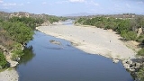
The Motagua River is a 486 km (302 mi) long river in Guatemala
. It rises in the western highlands of Guatemala where it is also called Río Grande, and runs in an easterly direction to the Gulf of Honduras
. The final few kilometres of the river form part of the Guatemala/Honduras
border. The Motagua River basin covers an area of 12670 km² (4,891.9 sq mi) and is the largest in Guatemala.
The river runs in a valley that has the only known source of jadeitite
(jade) in Mesoamerica
, and was an important commerce route during the Pre-Columbian
era. The important Maya
site of Quirigua
is near the river's north bank, as are several smaller sites with jade quarries and workshops.
The Motagua river valley also marks the Motagua Fault
, the tectonic boundary
between the North American
and the Caribbean Plate
s. The Motagua fault has been the source of several major earthquakes in Guatemala
. Much like lake Amatitlán
, the river is highly polluted with untreated sewage
, industrial waste, tons of sediment (garbage) and blackwater from Guatemala City
.
, Río Grande, Río Ovejas, Río El Tambor, Río San Vicente, Río Grande o Zapaca
, Río Carí, Río Las Naranjas, Río Biafra, Río El Islote, Río Jubuco, Río Lagarto, Río Tepemechín, Río Juyamá, Río Bobos
, Río Animas, Río Chiquito, Río Nuevo o Cacao
Guatemala
Guatemala is a country in Central America bordered by Mexico to the north and west, the Pacific Ocean to the southwest, Belize to the northeast, the Caribbean to the east, and Honduras and El Salvador to the southeast...
. It rises in the western highlands of Guatemala where it is also called Río Grande, and runs in an easterly direction to the Gulf of Honduras
Gulf of Honduras
The Gulf or Bay of Honduras is a large inlet of the Caribbean Sea, indenting the coasts of Belize, Guatemala, and Honduras. From north to south, it runs for approximately 200 km from Dangriga, Belize, to La Ceiba, Honduras....
. The final few kilometres of the river form part of the Guatemala/Honduras
Honduras
Honduras is a republic in Central America. It was previously known as Spanish Honduras to differentiate it from British Honduras, which became the modern-day state of Belize...
border. The Motagua River basin covers an area of 12670 km² (4,891.9 sq mi) and is the largest in Guatemala.
The river runs in a valley that has the only known source of jadeitite
Jadeitite
Jadeitite is a metamorphic rock found in blueschist grade metamorphic terrains. It is found in isolated metasomatically altered bodies within serpentinite associated with subduction zone environments. Jadeitite consists almost entirely of jadeite pyroxene and is typically mined as a source of the...
(jade) in Mesoamerica
Jade use in Mesoamerica
Jade use in Mesoamerica was largely influenced by the conceptualization of the material as a rare and valued commodity among pre-Columbian Mesoamerican cultures, such as the Olmec, the Maya, and the various groups in the Valley of Mexico. The only source from which the indigenous cultures could...
, and was an important commerce route during the Pre-Columbian
Pre-Columbian
The pre-Columbian era incorporates all period subdivisions in the history and prehistory of the Americas before the appearance of significant European influences on the American continents, spanning the time of the original settlement in the Upper Paleolithic period to European colonization during...
era. The important Maya
Maya civilization
The Maya is a Mesoamerican civilization, noted for the only known fully developed written language of the pre-Columbian Americas, as well as for its art, architecture, and mathematical and astronomical systems. Initially established during the Pre-Classic period The Maya is a Mesoamerican...
site of Quirigua
Quiriguá
Quiriguá is an ancient Maya archaeological site in the department of Izabal in south-eastern Guatemala. It is a medium-sized site covering approximately along the lower Motagua River, with the ceremonial center about from the north bank. During the Maya Classic Period , Quiriguá was situated at...
is near the river's north bank, as are several smaller sites with jade quarries and workshops.
The Motagua river valley also marks the Motagua Fault
Motagua Fault
The Motagua Fault is a major, active left lateral-moving transform fault which cuts across Guatemala. It forms part of the tectonic boundary between the North American Plate and the Caribbean Plate...
, the tectonic boundary
Plate tectonics
Plate tectonics is a scientific theory that describes the large scale motions of Earth's lithosphere...
between the North American
North American Plate
The North American Plate is a tectonic plate covering most of North America, Greenland, Cuba, Bahamas, and parts of Siberia, Japan and Iceland. It extends eastward to the Mid-Atlantic Ridge and westward to the Chersky Range in eastern Siberia. The plate includes both continental and oceanic crust...
and the Caribbean Plate
Caribbean Plate
The Caribbean Plate is a mostly oceanic tectonic plate underlying Central America and the Caribbean Sea off the north coast of South America....
s. The Motagua fault has been the source of several major earthquakes in Guatemala
Earthquakes in Guatemala
Earthquakes are relatively frequent occurrences in Guatemala. The country lies in a major fault zone, known as the Motagua and Chixoy-Polochic fault complex, which cuts across Guatemala and forms the tectonic boundary between the Caribbean plate and the North American plate...
. Much like lake Amatitlán
Lake Amatitlán
Lake Amatitlán is a volcanic lake in south-central Guatemala, fairly close to Guatemala City. It lies in the central highlands, 1,186 m above sea level. Its maximum depth is 33 m and an average of 18 m...
, the river is highly polluted with untreated sewage
Sewage
Sewage is water-carried waste, in solution or suspension, that is intended to be removed from a community. Also known as wastewater, it is more than 99% water and is characterized by volume or rate of flow, physical condition, chemical constituents and the bacteriological organisms that it contains...
, industrial waste, tons of sediment (garbage) and blackwater from Guatemala City
Guatemala City
Guatemala City , is the capital and largest city of the Republic of Guatemala and Central America...
.
Left
Río Cocoya, Río Cotón, Río Suchicul, Río Morazán, Río Comajá, Río Lato, Río Huijo, Río La Palmilla, Río Teculutan, Río Pasabien, Río Hondo, Río Jones, RíoLos Achiotes, Río Mayuelas, Río El Lobo, Quebrada Agua Fría, Quebrada La Vegega, Río Las ConchasRight
Río Chipaca, Rio Agua Escondida, Rio Quisaya, Rio Pixcayá, Río Cotzibal, Río Las VacasLas Vacas River
The Las Vacas River is a river in Guatemala. It begins in the mountains in the eastern outskirts of Guatemala City and runs in a north-easterly direction to join the Motagua River where the departmental borders of El Progreso, Baja Verapaz and Guatemala converge...
, Río Grande, Río Ovejas, Río El Tambor, Río San Vicente, Río Grande o Zapaca
Río Grande de Zacapa
The Río Grande de Zacapa is a river in Guatemala. From its sources in the southern mountain range in the departments of Zacapa and Chiquimula the river flows northwards until it reaches the Motagua River at . The río Grande de Zacapa is 87 km long an its river basin covers an area of 2,462...
, Río Carí, Río Las Naranjas, Río Biafra, Río El Islote, Río Jubuco, Río Lagarto, Río Tepemechín, Río Juyamá, Río Bobos
Bobos River (Guatemala)
The Bobos River is a river in Guatemala. It rises in the Sierra de Caral, a small mountain range in the eastern department of Izabal and runs in a north-westerly direction to join the Motagua River....
, Río Animas, Río Chiquito, Río Nuevo o Cacao