
Montagu Island
Encyclopedia
Montagu Island is the largest of the South Sandwich Islands
, located in the Weddell Sea
off the coast of Antarctica. It is a part of the British Overseas Territory, the South Georgia and the South Sandwich Islands
and has the only active volcano in the United Kingdom
. It is located 60 km northeast from Bristol Island
and 62 km south from Saunders Island
.
The island was first sighted by James Cook
in 1775, and named after John Montagu, 4th Earl of Sandwich
and the First Lord of the British Admiralty at the time of its discovery. The first recorded landing was made by the British-Norwegian arctic explorer Carl Anton Larsen
in 1908.
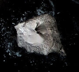
is its most notable geographic feature, rising to 1370 m above sea level. It was believed to be inactive prior to the sighting of low-level ash emission and suspected lava effusion in 2002 by the British Antarctic Survey
.
, imaging on Google Earth shows the volcano to be active with a noticeable plume and lava flow. The effects on the ice sheet are visible.
South Georgia and the South Sandwich Islands
South Georgia and the South Sandwich Islands is a British overseas territory and overseas territory of the European Union in the southern Atlantic Ocean. It is a remote and inhospitable collection of islands, consisting of South Georgia and a chain of smaller islands, known as the South Sandwich...
, located in the Weddell Sea
Weddell Sea
The Weddell Sea is part of the Southern Ocean and contains the Weddell Gyre. Its land boundaries are defined by the bay formed from the coasts of Coats Land and the Antarctic Peninsula. The easternmost point is Cape Norvegia at Princess Martha Coast, Queen Maud Land. To the east of Cape Norvegia is...
off the coast of Antarctica. It is a part of the British Overseas Territory, the South Georgia and the South Sandwich Islands
South Georgia and the South Sandwich Islands
South Georgia and the South Sandwich Islands is a British overseas territory and overseas territory of the European Union in the southern Atlantic Ocean. It is a remote and inhospitable collection of islands, consisting of South Georgia and a chain of smaller islands, known as the South Sandwich...
and has the only active volcano in the United Kingdom
United Kingdom
The United Kingdom of Great Britain and Northern IrelandIn the United Kingdom and Dependencies, other languages have been officially recognised as legitimate autochthonous languages under the European Charter for Regional or Minority Languages...
. It is located 60 km northeast from Bristol Island
Bristol Island
Bristol Island is an long island lying midway between Montagu Island and Thule Island in the South Sandwich Islands.Bristol Island is composed of several active volcanoes with eruptions reported in 1823, 1935, 1936, 1950 and 1956.-History:...
and 62 km south from Saunders Island
Saunders Island, South Sandwich Islands
Saunders Island is a crescent-shaped island long, lying between Candlemas Island and Montagu Island in the South Sandwich Islands, apart of the United Kingdom. It is a volcanic island composed of an active stratovolcano, Mount Michael. It's known to have erupted explosively in 1819, and has...
.
The island was first sighted by James Cook
James Cook
Captain James Cook, FRS, RN was a British explorer, navigator and cartographer who ultimately rose to the rank of captain in the Royal Navy...
in 1775, and named after John Montagu, 4th Earl of Sandwich
John Montagu, 4th Earl of Sandwich
John Montagu, 4th Earl of Sandwich, PC, FRS was a British statesman who succeeded his grandfather, Edward Montagu, 3rd Earl of Sandwich, as the Earl of Sandwich in 1729, at the age of ten...
and the First Lord of the British Admiralty at the time of its discovery. The first recorded landing was made by the British-Norwegian arctic explorer Carl Anton Larsen
Carl Anton Larsen
Carl Anton Larsen was a Norwegian Antarctic Explorer, who made important contributions to the exploration of Antarctica, the most significant being the first discovery of fossils, for which he received the Back Grant from the Royal Geographical Society...
in 1908.
Geography
The desolate, uninhabited island measures approximately 12 by, with over 90% of its surface permanently covered in ice. The volcano Mount BelindaMount Belinda
Mount Belinda is a stratovolcano located on Montagu Island, in the South Sandwich Islands of the Scotia Sea. A part of the British Overseas Territory, the South Georgia and the South Sandwich Islands, it is considered the only active volcano in the United Kingdom.Belinda was inactive until late...
is its most notable geographic feature, rising to 1370 m above sea level. It was believed to be inactive prior to the sighting of low-level ash emission and suspected lava effusion in 2002 by the British Antarctic Survey
British Antarctic Survey
The British Antarctic Survey is the United Kingdom's national Antarctic operation and has an active role in Antarctic affairs. BAS is part of the Natural Environment Research Council and has over 400 staff. It operates five research stations, two ships and five aircraft in and around Antarctica....
.
Mount Belinda
In November 2005, satellite images revealed that an eruption of Mount Belinda had created a 90 metres (295 ft) wide molten river flowing to the northern shoreline of the island. The event has expanded the area of the island by 0.2 square kilometre (0.077220431718507 sq mi), and provided some of the first scientific observations of volcanic eruptions taking place underneath an ice sheet., imaging on Google Earth shows the volcano to be active with a noticeable plume and lava flow. The effects on the ice sheet are visible.
Sources
External links
- Montagu Island - The Island Eencyclopedia at Oceandots.com