

San Gabriel River (California)
Encyclopedia
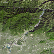
The San Gabriel River flows 60.6 miles (97.5 km) through southern Los Angeles County, California
in the United States
. Its main stem
is about 43 miles (69.2 km) long, while its farthest tributaries extend almost 18 miles (29 km) altogether. It drains a long, narrow watershed basin
extending from high in the San Gabriel Mountains
above the eastern Los Angeles Basin
, across the San Gabriel Valley
, to the Pacific Ocean
.
The river derives its name from the Spanish Mission San Gabriel Arcángel
founded in 1771, now in the present day city of San Gabriel
. It was free flowing with natural banks
and a riparian zone
habitat
lined with riparian forest
s, marsh
es, and grassland
s for much of its length
and a large estuary
at its mouth until the last century. Today most of the San Gabriel after leaving the foothills is restrained in a broad concrete flood control channel
, and impounded in places by debris and stormwater management pond
dam
s.
inside the Angeles National Forest
, form the source headwaters
of the river. The East Fork, sometimes considered part of the main stem, rises in the shadow of Mount San Antonio
as two smaller forks of its own, the Prairie Fork and the Fish Fork. The East Fork officially begins at the confluence of the Prairie Fork and a smaller tributary, Vincent Gulch. The Fish Fork and the main stem combine at the base of Iron Mountain in a canyon nearly 5000 feet (1,524 m) deep. From there, the East Fork flows south then turns west, flowing into the east arm of San Gabriel Reservoir. The similarly sized West Fork starts near San Gabriel Peak
near the Angeles Crest Highway
and flows east before being impounded in Cogswell Reservoir, where it receives Devils Canyon Creek. The river continues to flow east and receives Bear Creek from the left before combining with the North Fork, which rises near Mount Islip
.
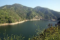
San Gabriel Reservoir
and Morris Reservoir
, both formed by flood prevention dams built in the 20th Century, submerge most of the upper stretches of the main stem San Gabriel. It is not long after the river leaves the San Gabriel Canyon and exits from the mountains into the San Gabriel Valley
near the city of Azusa
. The normally dry riverbed proceeds southwest to the Santa Fe Dam
, which impounds the river in the Santa Fe Flood Control Basin. After exiting the dam, the river flows south in a flood control channel
roughly parallel to Interstate 605
, also called the San Gabriel River Freeway, past Covina
and El Monte
, receives Walnut Creek and San Jose Creek from the left in quick succession, then proceeds into the Whittier Narrows
where it is impounded behind Whittier Narrows Dam
. Here, the river receives the Rio Hondo
from the right, then splits in two immediately after: the main stem continues to flow south, while the Rio Hondo carries a portion of the water southwest to empty into the Los Angeles River
near Downey
.
 The San Gabriel River, however, continues to flow south, past Bellflower
and Cerritos
. It forms the boundary between Los Angeles and Orange
Counties for a brief stretch before merging with Coyote Creek
, one of its main tributaries, near Los Alamitos
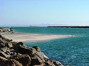
. The river eventually becomes tidal and empties into the outlet of Alamitos Bay
between the cities of Long Beach
and Seal Beach
.
area of 713 mi2 in eastern Los Angeles County and northwestern Orange County. It is the middle of the three major rivers of the Los Angeles Basin
, with its watershed bounded on the west by the Los Angeles River
and on the southeast by the Santa Ana River
watersheds. To the north is the arid interior endorheic drainage basin of the Mojave Desert
and Mojave River
. The San Gabriel River mainly flows along the west side of its watershed.
There are 37 major cities in the San Gabriel River watershed, 19 of which are actually situated on the river. In total, 26% of the watershed is covered by heavy development. Some tributaries of the river include Bear Creek, Walnut Creek, San Jose Creek, and Coyote Creek. The latter three are all large eastern tributaries that drain areas in excess of 40 mi2. San Jose Creek flows nearly 20 miles (32.2 km) westwards from Pomona
into the San Gabriel. Because most of the water from the mountains is stored in reservoirs and diverted for municipal use, the tributaries provide most of the flow below the Santa Fe Dam.
The northern part of the watershed is dominated by the San Gabriel Mountains
, one of the Transverse Ranges
, which were formed by seismic activity along the San Andreas Fault
, a major fault system in turn created by the collision of the North American Plate
and the Pacific Plate
. Before these two plates collided, the San Gabriel River did not even exist. It was only after the San Gabriel Mountains rose about 75 million years ago, that the river first began to form. Changes in sea level
, especially during the Ice Age
, deposited thousands of feet of marine sediments in the flood plain south of the San Gabriel Mountains over which the San Gabriel River now flows. The San Rafael Hills
, Puente Hills
, and Chino Hills
that cross the lower part of the watershed were formed by slippage of the Whittier Fault
, part of a smaller fault system that formed the Peninsular Ranges
.
 For geologic epochs
the river ran freely across arid grassland
s and through riparian zone
s and extensive marsh
es to the Pacific Ocean, flooding in the winter and spring then running nearly dry in the summer and fall. Once out of the mountains, the river's course would change frequently with every heavy inundation. Sometimes, the river would change course to run into the Los Angeles River
in the west, and sometimes the Santa Ana River
's floodwaters would travel westwards into the San Gabriel from Santa Ana Canyon
.
The San Gabriel River basin was historically part of the homeland, for over 8,000 years, of the Tongva—Gabrieleño Native American people
. Together with the Los Angeles and Santa Ana Rivers, the San Gabriel River provided sustenance for thousands of members
of this powerful coastal tribe whose territory extended across the entire Los Angeles basin
, San Fernando Valley
, and Channel Islands
. The Tongva had permanent settlements and temporary hunting and foraging camps in their territory.
In 1771, the Spanish
invaded
and founded Mission San Gabriel Arcángel
which was originally built on the banks of the Rio Hondo
, a tributary
of the San Gabriel River in the Whittier Narrows
, in 1771. After being flooded in 1776 it was relocated to the location, now in the present day City of San Gabriel
. The river's Spanish name
is from the mission's. The Spanish colonizers also renamed the Tongva people, as the Gabrieleño Mission Indians
after they were relocated
to the mission.
After California was admitted to the United States in 1850, the Pueblo de Los Angeles
founded in 1781, grew into the City of Los Angeles
. In this period, agriculture
and ranching, on the lands of the former Spanish and Mexican land grant
Ranchos
, were the primary economy of the San Gabriel River basin. When the railroads arrived, and especially after the Los Angeles Aqueduct
began service in 1913, the development booms in the basin expanded greatly, creating many of the towns and cities that now line the San Gabriel River. Some such as Whittier
, were named after their founders, and others, such as Azusa
, derived from the location's Tongva language
settlement placename, although contemporary legend tell it's from "everything from 'A' to 'Z' in the 'USA'."
and the Los Angeles Flood of 1938
, which produced some of the highest flows ever recorded in the river. The 1938 flood raised the river to some 65700 cuft/s according to a U.S. Geological Survey river gauge near Azusa
; although the 1862 flood probably produced an even higher flow, its discharge was not recorded. The flood of 1938 would have been far worse if it were not for the dams already on the San Gabriel River, which knocked nearly 85000 cuft/s off the crest of the flood. As a result, the U.S. Army Corps of Engineers began an ambitious effort to prevent flooding along the river in the lowlands. Much of the river downstream of Azusa was diked, channeled, lined with riprap
or paved over with concrete. A cascade of 10 drop structure
s was constructed where the river empties out of San Gabriel Canyon to slow flood flows from the mountains. Check dam
s were constructed in upper canyons and the river itself was impounded in several artificial lakes. (See #River modifications.)
The increased flood protection afforded by the dams, stormwater management pond
s, and flood control channel
s led to a housing boom from the 1950s to the 1980s. Most of the lowlands and agricultural areas in the watershed were built and paved over to construct residential, commercial, and industrial districts. Except for the Angeles National Forest
protected San Gabriel Mountains
and the Puente Hills
between the San Gabriel Valley
and the Los Angeles Basin, the remaining former flood plain land in the watershed was filled with urban sprawl
developments. The river's reservoirs also provide a small amount of municipal water.
 Like most rivers in Southern California
, the San Gabriel River today bears little resemblance to the river it was before the arrival of early Spanish colonial settlers
and Californios of Alta California
. It is dam
med five times along its length: once along the West Fork by the Prescott F. Cogswell Dam, then twice more downstream of the forks in the San Gabriel Mountains to create reservoirs at the San Gabriel Dam
, and at the former naval test site Morris Dam
; at the Santa Fe Dam
in the Santa Fe Dam Flood Control Basin in Irwindale
; and with the nearby Rio Hondo
(to which it is also connected by a short channel) at the Whittier Narrows Dam
, between the cities of South El Monte
and Pico Rivera
. Its channel is lined with concrete
for most of its length below the mountains. These alterations were made in response to disastrous flash flood
s in the late 19th and early 20th centuries. During periods of heavy rain
fall, the Los Angeles District of the U.S. Army Corps of Engineers can shift flows between the Rio Hondo
(a tributary of the Los Angeles River) and the San Gabriel River.
The San Gabriel River course is also the site for companion highways. In the lowlands it is adjoined by the San Gabriel River Freeway (Interstate 605) which replaced an older Rivergrade Road. Into the San Gabriel Canyon it is followed by State Route 39
to a terminus nearly 30 miles upstream.
As with the similarly modified Los Angeles River
, the San Gabriel is a notorious symbol of gross environmental degradation and destruction. Efforts to restore its river ecology and riparian habitats
are growing. Historically they have had limited success due to the artificial concrete, water pollution
and fertilizer
runoff.
 From mouth to source (year built in parentheses):
California
California is a state located on the West Coast of the United States. It is by far the most populous U.S. state, and the third-largest by land area...
in the United States
United States
The United States of America is a federal constitutional republic comprising fifty states and a federal district...
. Its main stem
Main Stem
"Main Stem" is 1942 instrumental by Duke Ellington and His Famous Orchestra. Although recorded in 1942, the single would not be released until 1944 where it was Duke Ellington's last of four number one's on the Harlem Hit Parade. "Main Stem" would also peak at number twenty on the pop chart"Main...
is about 43 miles (69.2 km) long, while its farthest tributaries extend almost 18 miles (29 km) altogether. It drains a long, narrow watershed basin
Drainage basin
A drainage basin is an extent or an area of land where surface water from rain and melting snow or ice converges to a single point, usually the exit of the basin, where the waters join another waterbody, such as a river, lake, reservoir, estuary, wetland, sea, or ocean...
extending from high in the San Gabriel Mountains
San Gabriel Mountains
The San Gabriel Mountains Range is located in northern Los Angeles County and western San Bernardino County, California, United States. The mountain range lies between the Los Angeles Basin and the Mojave Desert, with Interstate 5 to the west and Interstate 15 to the east...
above the eastern Los Angeles Basin
Los Angeles Basin
The Los Angeles Basin is the coastal sediment-filled plain located between the Peninsular and Transverse ranges in southern California in the United States containing the central part of the city of Los Angeles as well as its southern and southeastern suburbs...
, across the San Gabriel Valley
San Gabriel Valley
The San Gabriel Valley is one of the principal valleys of Southern California, United States. It lies to the east of Los Angeles, to the north of the Puente Hills, to the south of the San Gabriel Mountains, and west of the Inland Empire. It derives its name from the San Gabriel River that flows...
, to the Pacific Ocean
Pacific Ocean
The Pacific Ocean is the largest of the Earth's oceanic divisions. It extends from the Arctic in the north to the Southern Ocean in the south, bounded by Asia and Australia in the west, and the Americas in the east.At 165.2 million square kilometres in area, this largest division of the World...
.
The river derives its name from the Spanish Mission San Gabriel Arcángel
Mission San Gabriel Arcángel
The Mission San Gabriel Arcángel is a fully functioning Roman Catholic mission and a historic landmark in San Gabriel, California. The settlement was founded by Spaniards of the Franciscan order on "The Feast of the Birth of Mary," September 8, 1771, as the fourth of what would become 21 Spanish...
founded in 1771, now in the present day city of San Gabriel
San Gabriel, California
San Gabriel is a city in Los Angeles County, California, United States. It is named after the Mission San Gabriel Arcángel, founded by Junipero Serra. The city grew outward from the mission and in 1852 became the original township of Los Angeles County. San Gabriel was incorporated in 1913...
. It was free flowing with natural banks
Bank (geography)
A geographic bank has four definitions and applications:# Limnology: The shoreline of a pond, swamp, estuary, reservoir, or lake. The grade can vary from vertical to a shallow slope....
and a riparian zone
Riparian zone
A riparian zone or riparian area is the interface between land and a river or stream. Riparian is also the proper nomenclature for one of the fifteen terrestrial biomes of the earth. Plant habitats and communities along the river margins and banks are called riparian vegetation, characterized by...
habitat
Habitat
* Habitat , a place where a species lives and grows*Human habitat, a place where humans live, work or play** Space habitat, a space station intended as a permanent settlement...
lined with riparian forest
Riparian forest
A riparian forest is a forested area of land adjacent to a body of water such as a river, stream, pond, lake, marshland, estuary, canal, sink or reservoir. -Etymology:...
s, marsh
Marsh
In geography, a marsh, or morass, is a type of wetland that is subject to frequent or continuous flood. Typically the water is shallow and features grasses, rushes, reeds, typhas, sedges, other herbaceous plants, and moss....
es, and grassland
Grassland
Grasslands are areas where the vegetation is dominated by grasses and other herbaceous plants . However, sedge and rush families can also be found. Grasslands occur naturally on all continents except Antarctica...
s for much of its length
Stream bed
A stream bed is the channel bottom of a stream, river or creek; the physical confine of the normal water flow. The lateral confines or channel margins, during all but flood stage, are known as the stream banks or river banks. In fact, a flood occurs when a stream overflows its banks and flows onto...
and a large estuary
Estuary
An estuary is a partly enclosed coastal body of water with one or more rivers or streams flowing into it, and with a free connection to the open sea....
at its mouth until the last century. Today most of the San Gabriel after leaving the foothills is restrained in a broad concrete flood control channel
Flood control channel
Flood control channels are a series of large and empty open-air channels that extend a ways below the street levels of some larger cities, so that if and when a flood occurs, the flood will run into the channels, and proceed to be drained to the proper body of water...
, and impounded in places by debris and stormwater management pond
Stormwater management pond
Stormwater management ponds collect and retain urban stormwater. They are frequently built into urban areas in North America to also retain sediments and other materials....
dam
Dam
A dam is a barrier that impounds water or underground streams. Dams generally serve the primary purpose of retaining water, while other structures such as floodgates or levees are used to manage or prevent water flow into specific land regions. Hydropower and pumped-storage hydroelectricity are...
s.
Course
The East, West and North Forks of the San Gabriel River, rising in the San Gabriel MountainsSan Gabriel Mountains
The San Gabriel Mountains Range is located in northern Los Angeles County and western San Bernardino County, California, United States. The mountain range lies between the Los Angeles Basin and the Mojave Desert, with Interstate 5 to the west and Interstate 15 to the east...
inside the Angeles National Forest
Angeles National Forest
The Angeles National Forest of the U.S. National Forest Service is located in the San Gabriel Mountains of Los Angeles County, southern California. It was established on July 1, 1908, incorporating the first San Bernardino National Forest and parts of the former Santa Barbara and San Gabriel...
, form the source headwaters
Source (river or stream)
The source or headwaters of a river or stream is the place from which the water in the river or stream originates.-Definition:There is no universally agreed upon definition for determining a stream's source...
of the river. The East Fork, sometimes considered part of the main stem, rises in the shadow of Mount San Antonio
Mount San Antonio
Mount San Antonio, commonly known as Old Baldy or Mt Baldy, at , is the highest peak in the San Gabriel Mountains, and the highest point in Los Angeles County...
as two smaller forks of its own, the Prairie Fork and the Fish Fork. The East Fork officially begins at the confluence of the Prairie Fork and a smaller tributary, Vincent Gulch. The Fish Fork and the main stem combine at the base of Iron Mountain in a canyon nearly 5000 feet (1,524 m) deep. From there, the East Fork flows south then turns west, flowing into the east arm of San Gabriel Reservoir. The similarly sized West Fork starts near San Gabriel Peak
San Gabriel Peak
San Gabriel Peak is a summit in the San Gabriel Mountains in the U.S. state of California. It was named by the United States Geological Survey in 1894 and is located in the Angeles National Forest. This peak was first named The Commodore for Commodore Perry Switzer.The name is derived from the...
near the Angeles Crest Highway
Angeles Crest Highway
The Angeles Crest Highway is a two-lane segment of California State Route 2 in the United States. The road is in length, with its western terminus at the intersection at Foothill Boulevard in La Cañada Flintridge and its eastern terminus at State Route 138 northeast of Wrightwood...
and flows east before being impounded in Cogswell Reservoir, where it receives Devils Canyon Creek. The river continues to flow east and receives Bear Creek from the left before combining with the North Fork, which rises near Mount Islip
Mount Islip
Mount Islip is a peak in the Angeles National Forest. On a clear day the sharp, high peak provides impressive views of both the Mojave Desert and the Los Angeles Basin all the way to the ocean....
.
San Gabriel Reservoir
San Gabriel Dam
San Gabriel Dam is a rockfill dam on the San Gabriel River in the San Gabriel Mountains, in Los Angeles County, California, within the Angeles National Forest...
and Morris Reservoir
Morris reservoir
Morris Reservoir is located in the San Gabriel Mountains about 5 miles north of the city of Azusa along California State Route 39. Morris Reservoir is below San Gabriel Dam. The mean elevation is about 1100 ft...
, both formed by flood prevention dams built in the 20th Century, submerge most of the upper stretches of the main stem San Gabriel. It is not long after the river leaves the San Gabriel Canyon and exits from the mountains into the San Gabriel Valley
San Gabriel Valley
The San Gabriel Valley is one of the principal valleys of Southern California, United States. It lies to the east of Los Angeles, to the north of the Puente Hills, to the south of the San Gabriel Mountains, and west of the Inland Empire. It derives its name from the San Gabriel River that flows...
near the city of Azusa
Azusa, California
Azusa is a city in Los Angeles County, California, United States. The population was 46,361 at the 2010 census, up from 44,712 at the 2000 census. Though sometimes assumed to be a compaction of the phrase "everything from A to Z in the USA" from an old Jack Benny joke, the place name "Azusa"...
. The normally dry riverbed proceeds southwest to the Santa Fe Dam
Santa Fe Dam
Santa Fe Dam is a flood-control dam on the San Gabriel River located a few miles southwest of Azusa in Los Angeles County, California. For most of the year, the -high dam and its reservoir lie empty, but can hold more than of water during major storms...
, which impounds the river in the Santa Fe Flood Control Basin. After exiting the dam, the river flows south in a flood control channel
Flood control channel
Flood control channels are a series of large and empty open-air channels that extend a ways below the street levels of some larger cities, so that if and when a flood occurs, the flood will run into the channels, and proceed to be drained to the proper body of water...
roughly parallel to Interstate 605
Interstate 605
Interstate 605 is a major north–south Interstate Highway in the Greater Los Angeles Area of Southern California...
, also called the San Gabriel River Freeway, past Covina
Covina, California
Covina is a small city in Los Angeles County, California about east of downtown Los Angeles, in the San Gabriel Valley region. The population was 47,796 at the 2010 census, up from 46,837 at the 2000 census...
and El Monte
El Monte, California
El Monte is a residential, industrial, and commercial city in Los Angeles County, California, United States. The city's slogan is "Welcome to Friendly El Monte," and historically is known as "The End of the Santa Fe Trail." As of the 2010 census, the city had a total population of 113,475,...
, receives Walnut Creek and San Jose Creek from the left in quick succession, then proceeds into the Whittier Narrows
Whittier Narrows
The Whittier Narrows is located at the southern boundary of the San Gabriel Valley, in Los Angeles County, California. It is a gap in the Puente Hills where the Rio Hondo and the San Gabriel River diverge....
where it is impounded behind Whittier Narrows Dam
Whittier Narrows Dam
Whittier Narrows Dam is a dam on the San Gabriel River in Montebello, California. Built by the U.S. Army Corps of Engineers for flood control, it is a 17 m tall earth dam. Construction of the dam was completed in 1957. Its reservoir has a capacity of .-External links:*...
. Here, the river receives the Rio Hondo
Rio Hondo
Río Hondo or Hondo River may refer to:*Río Hondo, Zacapa, a municipality in the Guatemalan department of Zacapa*Rio Hondo , a river which forms much of the border between Belize and Mexico...
from the right, then splits in two immediately after: the main stem continues to flow south, while the Rio Hondo carries a portion of the water southwest to empty into the Los Angeles River
Los Angeles River
The Los Angeles River is a river that starts in the San Fernando Valley, in the Simi Hills and Santa Susana Mountains, and flows through Los Angeles County, California, from Canoga Park in the western end of the San Fernando Valley, nearly southeast to its mouth in Long Beach...
near Downey
Downey, California
Downey is a city located in southeast Los Angeles County, California, United States, southeast of downtown Los Angeles. The city is best known as the birthplace of the Apollo space program, and is the city where folk singer Karen Carpenter lived and died...
.
Bellflower, California
Bellflower is a city in Los Angeles County, California, and is a suburb of Los Angeles. It was incorporated on September 3, 1957. As of the 2010 census, the city had a total population of 76,616, up from 72,878 at the 2000 census....
and Cerritos
Cerritos, California
Cerritos is a city in Los Angeles County, California, United States, and is one of several cities that constitute the Gateway Cities of southeast Los Angeles County. It was incorporated on April 24, 1956...
. It forms the boundary between Los Angeles and Orange
Orange County, California
Orange County is a county in the U.S. state of California. Its county seat is Santa Ana. As of the 2010 census, its population was 3,010,232, up from 2,846,293 at the 2000 census, making it the third most populous county in California, behind Los Angeles County and San Diego County...
Counties for a brief stretch before merging with Coyote Creek
Coyote Creek (San Gabriel River)
Coyote Creek is a principal tributary of the San Gabriel River in northwest Orange County, southeast Los Angeles County, and southwest Riverside County in the U.S. state of California. It drains a land area of roughly covering five major cities, including Brea, Buena Park, Fullerton, La Habra, and...
, one of its main tributaries, near Los Alamitos
Los Alamitos, California
Los Alamitos is a small city in Orange County, California. The city was incorporated in March 1960. The population was 11,449 at the 2010 census, down from 11,536 at the 2000 census...
. The river eventually becomes tidal and empties into the outlet of Alamitos Bay
Alamitos Bay
Alamitos Bay is an inlet on the Pacific Ocean coast of southern California, United States, between the cities of Long Beach and Seal Beach, at the outlet of the San Gabriel River.The bay is named for the Spanish word for 'little poplars'.-Geography:...
between the cities of Long Beach
Long Beach, California
Long Beach is a city situated in Los Angeles County in Southern California, on the Pacific coast of the United States. The city is the 36th-largest city in the nation and the seventh-largest in California. As of 2010, its population was 462,257...
and Seal Beach
Seal Beach, California
-Neighborhoods:Seal Beach encompasses the Leisure World retirement gated community with roughly 9,000 residents. This was the first major planned retirement community of its type in the U.S...
.
Ecology
The San Gabriel River watershed has endangered Steelhead trout (Oncorhynchus mykiss). Genetic analysis of the steelhead show them to be of native and not hatchery stocks.Watershed
The San Gabriel River drains a watershed basinDrainage basin
A drainage basin is an extent or an area of land where surface water from rain and melting snow or ice converges to a single point, usually the exit of the basin, where the waters join another waterbody, such as a river, lake, reservoir, estuary, wetland, sea, or ocean...
area of 713 mi2 in eastern Los Angeles County and northwestern Orange County. It is the middle of the three major rivers of the Los Angeles Basin
Los Angeles Basin
The Los Angeles Basin is the coastal sediment-filled plain located between the Peninsular and Transverse ranges in southern California in the United States containing the central part of the city of Los Angeles as well as its southern and southeastern suburbs...
, with its watershed bounded on the west by the Los Angeles River
Los Angeles River
The Los Angeles River is a river that starts in the San Fernando Valley, in the Simi Hills and Santa Susana Mountains, and flows through Los Angeles County, California, from Canoga Park in the western end of the San Fernando Valley, nearly southeast to its mouth in Long Beach...
and on the southeast by the Santa Ana River
Santa Ana River
The Santa Ana River is the largest river of Southern California in the United States. Its drainage basin spans four counties. It rises in the San Bernardino Mountains and flows past the cities of San Bernardino and Riverside, before cutting through the northern tip of the Santa Ana Mountains and...
watersheds. To the north is the arid interior endorheic drainage basin of the Mojave Desert
Mojave Desert
The Mojave Desert occupies a significant portion of southeastern California and smaller parts of central California, southern Nevada, southwestern Utah and northwestern Arizona, in the United States...
and Mojave River
Mojave River
The Mojave River is an intermittent river in the eastern San Bernardino Mountains and Mojave Desert in San Bernardino County, California. The river is notable as most of its flow is underground, while its surface channels remain dry most of the time, with the exception of the headwaters and several...
. The San Gabriel River mainly flows along the west side of its watershed.
There are 37 major cities in the San Gabriel River watershed, 19 of which are actually situated on the river. In total, 26% of the watershed is covered by heavy development. Some tributaries of the river include Bear Creek, Walnut Creek, San Jose Creek, and Coyote Creek. The latter three are all large eastern tributaries that drain areas in excess of 40 mi2. San Jose Creek flows nearly 20 miles (32.2 km) westwards from Pomona
Pomona, California
-2010:The 2010 United States Census reported that Pomona had a population of 149,058, a slight decline from the 2000 census population. The population density was 6,491.2 people per square mile...
into the San Gabriel. Because most of the water from the mountains is stored in reservoirs and diverted for municipal use, the tributaries provide most of the flow below the Santa Fe Dam.
The northern part of the watershed is dominated by the San Gabriel Mountains
San Gabriel Mountains
The San Gabriel Mountains Range is located in northern Los Angeles County and western San Bernardino County, California, United States. The mountain range lies between the Los Angeles Basin and the Mojave Desert, with Interstate 5 to the west and Interstate 15 to the east...
, one of the Transverse Ranges
Transverse Ranges
The Transverse Ranges are a group of mountain ranges of southern California, in the Pacific Coast Ranges physiographic region that runs along the Pacific coast from Alaska to Mexico in North America. The Transverse Ranges begin at the southern end of the California Coast Ranges and lie between...
, which were formed by seismic activity along the San Andreas Fault
San Andreas Fault
The San Andreas Fault is a continental strike-slip fault that runs a length of roughly through California in the United States. The fault's motion is right-lateral strike-slip...
, a major fault system in turn created by the collision of the North American Plate
North American Plate
The North American Plate is a tectonic plate covering most of North America, Greenland, Cuba, Bahamas, and parts of Siberia, Japan and Iceland. It extends eastward to the Mid-Atlantic Ridge and westward to the Chersky Range in eastern Siberia. The plate includes both continental and oceanic crust...
and the Pacific Plate
Pacific Plate
The Pacific Plate is an oceanic tectonic plate that lies beneath the Pacific Ocean. At 103 million square kilometres, it is the largest tectonic plate....
. Before these two plates collided, the San Gabriel River did not even exist. It was only after the San Gabriel Mountains rose about 75 million years ago, that the river first began to form. Changes in sea level
Sea level
Mean sea level is a measure of the average height of the ocean's surface ; used as a standard in reckoning land elevation...
, especially during the Ice Age
Ice age
An ice age or, more precisely, glacial age, is a generic geological period of long-term reduction in the temperature of the Earth's surface and atmosphere, resulting in the presence or expansion of continental ice sheets, polar ice sheets and alpine glaciers...
, deposited thousands of feet of marine sediments in the flood plain south of the San Gabriel Mountains over which the San Gabriel River now flows. The San Rafael Hills
San Rafael Hills
The San Rafael Hills are a mountain range in Los Angeles County, California. They are one of the lower Transverse Ranges, and are parallel to and below the San Gabriel Mountains to the south, adjacent to the San Gabriel Valley overlooking the Los Angeles Basin.-Geography:The Hills contain all or...
, Puente Hills
Puente Hills
The Puente Hills is a chain of hills, one of the lower Transverse Ranges, in an unincorporated area in eastern Los Angeles County, California.-Geography:...
, and Chino Hills
Chino Hills
The Chino Hills are a mountain range on the border of Orange, Los Angeles, and San Bernardino Counties, California, with a small portion in Riverside County...
that cross the lower part of the watershed were formed by slippage of the Whittier Fault
Whittier Fault
The Whittier Fault is a geologic fault located in eastern Los Angeles County in Southern California, that is one of the two upper branches of the Elsinore Fault Zone, with the Chino Fault the second.-Geology:...
, part of a smaller fault system that formed the Peninsular Ranges
Peninsular Ranges
The Peninsular Ranges are a group of mountain ranges, in the Pacific Coast Ranges, which stretch from southern California in the United States to the southern tip of Mexico's Baja California peninsula; they are part of the North American Coast Ranges that run along the Pacific coast from Alaska...
.
History
Epoch (geology)
An epoch is a subdivision of the geologic timescale based on rock layering. In order, the higher subdivisions are periods, eras and eons. We are currently living in the Holocene epoch...
the river ran freely across arid grassland
Grassland
Grasslands are areas where the vegetation is dominated by grasses and other herbaceous plants . However, sedge and rush families can also be found. Grasslands occur naturally on all continents except Antarctica...
s and through riparian zone
Riparian zone
A riparian zone or riparian area is the interface between land and a river or stream. Riparian is also the proper nomenclature for one of the fifteen terrestrial biomes of the earth. Plant habitats and communities along the river margins and banks are called riparian vegetation, characterized by...
s and extensive marsh
Marsh
In geography, a marsh, or morass, is a type of wetland that is subject to frequent or continuous flood. Typically the water is shallow and features grasses, rushes, reeds, typhas, sedges, other herbaceous plants, and moss....
es to the Pacific Ocean, flooding in the winter and spring then running nearly dry in the summer and fall. Once out of the mountains, the river's course would change frequently with every heavy inundation. Sometimes, the river would change course to run into the Los Angeles River
Los Angeles River
The Los Angeles River is a river that starts in the San Fernando Valley, in the Simi Hills and Santa Susana Mountains, and flows through Los Angeles County, California, from Canoga Park in the western end of the San Fernando Valley, nearly southeast to its mouth in Long Beach...
in the west, and sometimes the Santa Ana River
Santa Ana River
The Santa Ana River is the largest river of Southern California in the United States. Its drainage basin spans four counties. It rises in the San Bernardino Mountains and flows past the cities of San Bernardino and Riverside, before cutting through the northern tip of the Santa Ana Mountains and...
's floodwaters would travel westwards into the San Gabriel from Santa Ana Canyon
Santa Ana Canyon
Santa Ana Canyon is where the Santa Ana River passes between the Santa Ana Mountains and the Chino Hills, near the intersection of Orange, Riverside, and San Bernardino Counties. It receives particularly strong Santa Ana winds in comparison to surrounding areas, hence the name.-History:Originally,...
.
The San Gabriel River basin was historically part of the homeland, for over 8,000 years, of the Tongva—Gabrieleño Native American people
Native Americans in the United States
Native Americans in the United States are the indigenous peoples in North America within the boundaries of the present-day continental United States, parts of Alaska, and the island state of Hawaii. They are composed of numerous, distinct tribes, states, and ethnic groups, many of which survive as...
. Together with the Los Angeles and Santa Ana Rivers, the San Gabriel River provided sustenance for thousands of members
Population of Native California
Estimates of the Native Californian population have varied substantially, both with respect to California's pre-contact count and for changes during subsequent periods. Pre-contact estimates range from 133,000 to 705,000 with some recent scholars concluding that these estimates are low...
of this powerful coastal tribe whose territory extended across the entire Los Angeles basin
Los Angeles Basin
The Los Angeles Basin is the coastal sediment-filled plain located between the Peninsular and Transverse ranges in southern California in the United States containing the central part of the city of Los Angeles as well as its southern and southeastern suburbs...
, San Fernando Valley
San Fernando Valley
The San Fernando Valley is an urbanized valley located in the Los Angeles metropolitan area of southern California, United States, defined by the dramatic mountains of the Transverse Ranges circling it...
, and Channel Islands
Channel Islands of California
The Channel Islands of California are a chain of eight islands located in the Pacific Ocean off the coast of Southern California along the Santa Barbara Channel in the United States of America...
. The Tongva had permanent settlements and temporary hunting and foraging camps in their territory.
In 1771, the Spanish
Spanish people
The Spanish are citizens of the Kingdom of Spain. Within Spain, there are also a number of vigorous nationalisms and regionalisms, reflecting the country's complex history....
invaded
Spanish colonization of the Americas
Colonial expansion under the Spanish Empire was initiated by the Spanish conquistadores and developed by the Monarchy of Spain through its administrators and missionaries. The motivations for colonial expansion were trade and the spread of the Christian faith through indigenous conversions...
and founded Mission San Gabriel Arcángel
Mission San Gabriel Arcángel
The Mission San Gabriel Arcángel is a fully functioning Roman Catholic mission and a historic landmark in San Gabriel, California. The settlement was founded by Spaniards of the Franciscan order on "The Feast of the Birth of Mary," September 8, 1771, as the fourth of what would become 21 Spanish...
which was originally built on the banks of the Rio Hondo
Rio Hondo
Río Hondo or Hondo River may refer to:*Río Hondo, Zacapa, a municipality in the Guatemalan department of Zacapa*Rio Hondo , a river which forms much of the border between Belize and Mexico...
, a tributary
Tributary
A tributary or affluent is a stream or river that flows into a main stem river or a lake. A tributary does not flow directly into a sea or ocean...
of the San Gabriel River in the Whittier Narrows
Whittier Narrows
The Whittier Narrows is located at the southern boundary of the San Gabriel Valley, in Los Angeles County, California. It is a gap in the Puente Hills where the Rio Hondo and the San Gabriel River diverge....
, in 1771. After being flooded in 1776 it was relocated to the location, now in the present day City of San Gabriel
San Gabriel, California
San Gabriel is a city in Los Angeles County, California, United States. It is named after the Mission San Gabriel Arcángel, founded by Junipero Serra. The city grew outward from the mission and in 1852 became the original township of Los Angeles County. San Gabriel was incorporated in 1913...
. The river's Spanish name
Spanish language
Spanish , also known as Castilian , is a Romance language in the Ibero-Romance group that evolved from several languages and dialects in central-northern Iberia around the 9th century and gradually spread with the expansion of the Kingdom of Castile into central and southern Iberia during the...
is from the mission's. The Spanish colonizers also renamed the Tongva people, as the Gabrieleño Mission Indians
Mission Indians
Mission Indians is a term for many Native California tribes, primarily living in coastal plains, adjacent inland valleys and mountains, and on the Channel Islands in central and southern California, United States. The tribes had established comparatively peaceful cultures varying from 250 to 8,000...
after they were relocated
Indian Reductions
Reductions were settlements founded by the Spanish colonizers of the New World with the purpose of assimilating indigenous populations into European culture and religion.Already since the beginning of the Spanish presence in the Americas, the Crown had been concerned...
to the mission.
After California was admitted to the United States in 1850, the Pueblo de Los Angeles
Pueblo de Los Angeles
El Pueblo de Nuestra Señora la Reina de los Ángeles was the Spanish civilian pueblo founded in 1781, which by the 20th century became the American metropolis of Los Angeles....
founded in 1781, grew into the City of Los Angeles
Los Ángeles
Los Ángeles is the capital of the province of Biobío, in the commune of the same name, in Region VIII , in the center-south of Chile. It is located between the Laja and Biobío rivers. The population is 123,445 inhabitants...
. In this period, agriculture
Agriculture
Agriculture is the cultivation of animals, plants, fungi and other life forms for food, fiber, and other products used to sustain life. Agriculture was the key implement in the rise of sedentary human civilization, whereby farming of domesticated species created food surpluses that nurtured the...
and ranching, on the lands of the former Spanish and Mexican land grant
Land grant
A land grant is a gift of real estate – land or its privileges – made by a government or other authority as a reward for services to an individual, especially in return for military service...
Ranchos
Ranchos of California
The Spanish, and later the Méxican government encouraged settlement of territory now known as California by the establishment of large land grants called ranchos, from which the English ranch is derived. Devoted to raising cattle and sheep, the owners of the ranchos attempted to pattern themselves...
, were the primary economy of the San Gabriel River basin. When the railroads arrived, and especially after the Los Angeles Aqueduct
Los Angeles Aqueduct
The Los Angeles Aqueduct system comprising the Los Angeles Aqueduct and the Second Los Angeles Aqueduct, is a water conveyance system operated by the Los Angeles Department of Water and Power...
began service in 1913, the development booms in the basin expanded greatly, creating many of the towns and cities that now line the San Gabriel River. Some such as Whittier
Whittier, California
Whittier is a city in Los Angeles County, California about southeast of Los Angeles. The city had a population of 85,331 at the 2010 census, up from 83,680 as of the 2000 census, and encompasses 14.7 square miles . Like nearby Montebello, the city constitutes part of the Gateway Cities...
, were named after their founders, and others, such as Azusa
Azusa, California
Azusa is a city in Los Angeles County, California, United States. The population was 46,361 at the 2010 census, up from 44,712 at the 2000 census. Though sometimes assumed to be a compaction of the phrase "everything from A to Z in the USA" from an old Jack Benny joke, the place name "Azusa"...
, derived from the location's Tongva language
Tongva language
-Collected by C. Hart Merriam :Numbers# Po-koo /bo'kʰøː/# Wěh-hā /ʋɛj'χɒː/# Pah-hā /pa'χɒː/# Wah-chah /ʋa'ʃɒχ/# Mah-har /ma'χɒʁ/# Pah-vah-hā /pa'va'χɒː/# Wah-chah-kav-e-ah /ʋa'ʃa'kʰav̥eʲa/...
settlement placename, although contemporary legend tell it's from "everything from 'A' to 'Z' in the 'USA'."
Floods
Devastating floods wreaked havoc along the San Gabriel River in the late 19th century and the early years of the 20th century. The most famous were the Great Flood of 1862Great Flood of 1862
The Great Flood of 1862 or Noachian Deluge was the largest flood in the recorded history of Oregon, Nevada and California, occurring from December 1861 to January 1862. It was preceded by weeks of continuous rains that began in Oregon in November 1861 and continued into January 1862...
and the Los Angeles Flood of 1938
Los Angeles Flood of 1938
The Los Angeles Flood of 1938 or 1938 Los Angeles flood was a major flooding event that was responsible for inundating much of Los Angeles, Orange, and Riverside counties, California, during early 1938...
, which produced some of the highest flows ever recorded in the river. The 1938 flood raised the river to some 65700 cuft/s according to a U.S. Geological Survey river gauge near Azusa
Azusa, California
Azusa is a city in Los Angeles County, California, United States. The population was 46,361 at the 2010 census, up from 44,712 at the 2000 census. Though sometimes assumed to be a compaction of the phrase "everything from A to Z in the USA" from an old Jack Benny joke, the place name "Azusa"...
; although the 1862 flood probably produced an even higher flow, its discharge was not recorded. The flood of 1938 would have been far worse if it were not for the dams already on the San Gabriel River, which knocked nearly 85000 cuft/s off the crest of the flood. As a result, the U.S. Army Corps of Engineers began an ambitious effort to prevent flooding along the river in the lowlands. Much of the river downstream of Azusa was diked, channeled, lined with riprap
Riprap
Riprap — also known as rip rap, rubble, shot rock or rock armour or "Rip-rap" — is rock or other material used to armor shorelines, streambeds, bridge abutments, pilings and other shoreline structures against scour, water or ice erosion.It is made from a variety of rock types, commonly granite or...
or paved over with concrete. A cascade of 10 drop structure
Drop structure
A drop structure, also known as a grade control, sill, or weir, is a manmade structure, typically small and built on minor streams, or as part of a dam's spillway, to pass water to a lower elevation while controlling the energy and velocity of the water as it passes over...
s was constructed where the river empties out of San Gabriel Canyon to slow flood flows from the mountains. Check dam
Check dam
A check dam is a small dam, which can be either temporary or permanent, built across a minor channel, swale, bioswale, or drainage ditch. Similar to drop structures in purpose, they reduce erosion and gullying in the channel and allow sediments and pollutants to settle. They also lower the speed of...
s were constructed in upper canyons and the river itself was impounded in several artificial lakes. (See #River modifications.)
The increased flood protection afforded by the dams, stormwater management pond
Stormwater management pond
Stormwater management ponds collect and retain urban stormwater. They are frequently built into urban areas in North America to also retain sediments and other materials....
s, and flood control channel
Flood control channel
Flood control channels are a series of large and empty open-air channels that extend a ways below the street levels of some larger cities, so that if and when a flood occurs, the flood will run into the channels, and proceed to be drained to the proper body of water...
s led to a housing boom from the 1950s to the 1980s. Most of the lowlands and agricultural areas in the watershed were built and paved over to construct residential, commercial, and industrial districts. Except for the Angeles National Forest
Angeles National Forest
The Angeles National Forest of the U.S. National Forest Service is located in the San Gabriel Mountains of Los Angeles County, southern California. It was established on July 1, 1908, incorporating the first San Bernardino National Forest and parts of the former Santa Barbara and San Gabriel...
protected San Gabriel Mountains
San Gabriel Mountains
The San Gabriel Mountains Range is located in northern Los Angeles County and western San Bernardino County, California, United States. The mountain range lies between the Los Angeles Basin and the Mojave Desert, with Interstate 5 to the west and Interstate 15 to the east...
and the Puente Hills
Puente Hills
The Puente Hills is a chain of hills, one of the lower Transverse Ranges, in an unincorporated area in eastern Los Angeles County, California.-Geography:...
between the San Gabriel Valley
San Gabriel Valley
The San Gabriel Valley is one of the principal valleys of Southern California, United States. It lies to the east of Los Angeles, to the north of the Puente Hills, to the south of the San Gabriel Mountains, and west of the Inland Empire. It derives its name from the San Gabriel River that flows...
and the Los Angeles Basin, the remaining former flood plain land in the watershed was filled with urban sprawl
Urban sprawl
Urban sprawl, also known as suburban sprawl, is a multifaceted concept, which includes the spreading outwards of a city and its suburbs to its outskirts to low-density and auto-dependent development on rural land, high segregation of uses Urban sprawl, also known as suburban sprawl, is a...
developments. The river's reservoirs also provide a small amount of municipal water.
River modifications
Southern California
Southern California is a megaregion, or megapolitan area, in the southern area of the U.S. state of California. Large urban areas include Greater Los Angeles and Greater San Diego. The urban area stretches along the coast from Ventura through the Southland and Inland Empire to San Diego...
, the San Gabriel River today bears little resemblance to the river it was before the arrival of early Spanish colonial settlers
Las Californias
The Californias, or in — - was the name given by the Spanish to their northwestern territory of New Spain, comprising the present day states of Baja California and Baja California Sur on the Baja California Peninsula in Mexico; and the present day U.S. state of California in the United States of...
and Californios of Alta California
Alta California
Alta California was a province and territory in the Viceroyalty of New Spain and later a territory and department in independent Mexico. The territory was created in 1769 out of the northern part of the former province of Las Californias, and consisted of the modern American states of California,...
. It is dam
Dam
A dam is a barrier that impounds water or underground streams. Dams generally serve the primary purpose of retaining water, while other structures such as floodgates or levees are used to manage or prevent water flow into specific land regions. Hydropower and pumped-storage hydroelectricity are...
med five times along its length: once along the West Fork by the Prescott F. Cogswell Dam, then twice more downstream of the forks in the San Gabriel Mountains to create reservoirs at the San Gabriel Dam
San Gabriel Dam
San Gabriel Dam is a rockfill dam on the San Gabriel River in the San Gabriel Mountains, in Los Angeles County, California, within the Angeles National Forest...
, and at the former naval test site Morris Dam
Morris reservoir
Morris Reservoir is located in the San Gabriel Mountains about 5 miles north of the city of Azusa along California State Route 39. Morris Reservoir is below San Gabriel Dam. The mean elevation is about 1100 ft...
; at the Santa Fe Dam
Santa Fe Dam Recreation Area
The Santa Fe Dam Recreation Area is a county park located in Irwindale, California, USA in the San Gabriel Valley and nestled among the gravel quarries in the area. It is maintained and operated by the Los Angeles County Department of Parks and Recreation...
in the Santa Fe Dam Flood Control Basin in Irwindale
Irwindale, California
Irwindale is a city in the San Gabriel Valley, in Los Angeles County, California, United States. The population was 1,422 at the 2010 census, down from 1,446 at the 2000 census....
; and with the nearby Rio Hondo
Rio Hondo (California)
The Rio Hondo is a tributary of the Los Angeles River in Los Angeles County, California, approximately long. As a named river, it begins in Irwindale and flows southwest to its confluence in South Gate, passing through several cities...
(to which it is also connected by a short channel) at the Whittier Narrows Dam
Whittier Narrows Dam
Whittier Narrows Dam is a dam on the San Gabriel River in Montebello, California. Built by the U.S. Army Corps of Engineers for flood control, it is a 17 m tall earth dam. Construction of the dam was completed in 1957. Its reservoir has a capacity of .-External links:*...
, between the cities of South El Monte
South El Monte, California
South El Monte is a city in the San Gabriel Valley, in Los Angeles County, California, United States. As of the 2010 census, the city had a population of 20,116, down from 21,144 at the 2000 census.-Geography:...
and Pico Rivera
Pico Rivera, California
Pico Rivera is a city located in southeastern Los Angeles County, California, United States. The city is situated approximately 11 miles southeast of downtown Los Angeles, on the eastern edge of the Los Angeles basin, and on the southern edge of the area known as the San Gabriel Valley...
. Its channel is lined with concrete
Concrete
Concrete is a composite construction material, composed of cement and other cementitious materials such as fly ash and slag cement, aggregate , water and chemical admixtures.The word concrete comes from the Latin word...
for most of its length below the mountains. These alterations were made in response to disastrous flash flood
Flash flood
A flash flood is a rapid flooding of geomorphic low-lying areas—washes, rivers, dry lakes and basins. It may be caused by heavy rain associated with a storm, hurricane, or tropical storm or meltwater from ice or snow flowing over ice sheets or snowfields...
s in the late 19th and early 20th centuries. During periods of heavy rain
Rain
Rain is liquid precipitation, as opposed to non-liquid kinds of precipitation such as snow, hail and sleet. Rain requires the presence of a thick layer of the atmosphere to have temperatures above the melting point of water near and above the Earth's surface...
fall, the Los Angeles District of the U.S. Army Corps of Engineers can shift flows between the Rio Hondo
Rio Hondo (California)
The Rio Hondo is a tributary of the Los Angeles River in Los Angeles County, California, approximately long. As a named river, it begins in Irwindale and flows southwest to its confluence in South Gate, passing through several cities...
(a tributary of the Los Angeles River) and the San Gabriel River.
The San Gabriel River course is also the site for companion highways. In the lowlands it is adjoined by the San Gabriel River Freeway (Interstate 605) which replaced an older Rivergrade Road. Into the San Gabriel Canyon it is followed by State Route 39
California State Route 39
State Route 39 is a state highway in the U.S. state of California that travels through Orange and Los Angeles counties. Its southern terminus is at Pacific Coast Highway , in Huntington Beach, and its northern terminus is at Islip Saddle on Angeles Crest Highway in the Angeles National...
to a terminus nearly 30 miles upstream.
As with the similarly modified Los Angeles River
Los Angeles River
The Los Angeles River is a river that starts in the San Fernando Valley, in the Simi Hills and Santa Susana Mountains, and flows through Los Angeles County, California, from Canoga Park in the western end of the San Fernando Valley, nearly southeast to its mouth in Long Beach...
, the San Gabriel is a notorious symbol of gross environmental degradation and destruction. Efforts to restore its river ecology and riparian habitats
Riparian zone restoration
Riparian zone restoration is the ecological restoration of riparian zone habitats of streams, rivers, springs, lakes, floodplains, and other hydrologic ecologies.Riparian zones have been degraded throughout much of the world...
are growing. Historically they have had limited success due to the artificial concrete, water pollution
Water pollution
Water pollution is the contamination of water bodies . Water pollution occurs when pollutants are discharged directly or indirectly into water bodies without adequate treatment to remove harmful compounds....
and fertilizer
Fertilizer
Fertilizer is any organic or inorganic material of natural or synthetic origin that is added to a soil to supply one or more plant nutrients essential to the growth of plants. A recent assessment found that about 40 to 60% of crop yields are attributable to commercial fertilizer use...
runoff.
Crossings
- Marina Drive (1963)
- State Route 1California State Route 1State Route 1 , more often called Highway 1, is a state highway that runs along much of the Pacific coast of the U.S. state of California. It is famous for running along some of the most beautiful coastlines in the world, leading to its designation as an All-American Road.Highway 1 does not run...
- Pacific Coast Highway (1931) - Westminster Avenue - twin bridges (1964)
- State Route 22California State Route 22State Route 22 in the U.S. state of California is an east–west highway in southern Los Angeles County and northern Orange County. It runs between Long Beach and Orange by way of Garden Grove. The westernmost part of it is a surface street, Long Beach's 7th Street. From Long Beach to its...
- East 7th St - twin bridges (1941, 1959) - College Park Drive (1964)
- Southbound Interstate 605 ramp to northbound Interstate 405 (1966)
- Interstate 405Interstate 405 (California)Interstate 405 is a major north–south Interstate Highway in Southern California. It is a bypass of Interstate 5, running along the western areas of the Greater Los Angeles Area from Irvine in the south to near San Fernando in the north...
- San Diego Freeway (1964) - Southbound Interstate 405 ramp to northbound Interstate 605 (1966)
- East Willow Street (1962)
- East Spring Street (1952)
- East Wardlow Road (1963)
- San Gabriel River Bicycle Path [bike bridge]
- Carson Street - twin bridges (1971)
- Del Amo Boulevard (1966)
- South Street (1952)
- 183rd Street (1972)
- Artesia Boulevard (1941)
- Railroad
- State Route 91California State Route 91State Route 91 is a major east–west freeway located entirely within Southern California and serving several regions of the Greater Los Angeles metropolitan area...
- Artesia Freeway (1968) - [Pedestrian Bridge]
- Alondra Boulevard (1952)
- Rosecrans Avenue (1951)
- Foster Road [Pedestrian Bridge]
- Eastbound Interstate 105 ramps to Interstate 605 (1987)
- Interstate 105Interstate 105 (California)Interstate 105 is an Interstate Highway in southern Los Angeles County, California that runs east–west from near the Los Angeles International Airport to Norwalk...
- Glenn Anderson Freeway and Metro Green Line (1987) - Interstate 605 ramps to westbound Interstate 105 (1987)
- Imperial Highway (1952)
- Railroad
- Firestone Boulevard (1934)
- Florence Avenue (1951)
- Interstate 5Interstate 5 in CaliforniaInterstate 5 is a major north–south route of the Interstate Highway System in the U.S. state of California. It begins at the Mexico – United States border at the San Ysidro crossing, goes north across the length of California and crosses into Oregon south of the Medford-Ashland metropolitan...
- Santa Ana Freeway (1953) - Telegraph Road (1937)
- Railroad
- Slauson Avenue (1958)
- Railroad
- Washington Boulevard (1953)
- State Route 72California State Route 72State Route 72 is a state highway in the U.S. state of California. The route runs from Puente Street in Brea to Atlantic Boulevard in East Los Angeles. It forms part of El Camino Real.-Route description:...
- Whittier Boulevard (1968) - Railroad
- East Beverly Boulevard (1952)
- San Gabriel River Parkway (1954)
- Whittier Narrows Dam
- Peck Road - twin bridges (1952)
- State Route 60California State Route 60State Route 60 is a state highway in the U.S. state of California. It runs from Interstate 10 near the Los Angeles River in Los Angeles east to I-10 in Riverside County, with overlaps at State Route 57 and Interstate 215.-Route description:...
- Pomona Freeway (1967) - Valley Boulevard (1916)
- Railroad
- Interstate 10Interstate 10 in CaliforniaInterstate 10 , the major east–west Interstate Highway in the Southern United States, runs in the U.S. state of California east from Santa Monica, on the Pacific Ocean, through Los Angeles and San Bernardino to the border with Arizona...
- San Bernardino Freeway (westbound 1933, eastbound 1956) - Ramona Boulevard (1961)
- Lower Azusa Road (1960)
- Interstate 605Interstate 605Interstate 605 is a major north–south Interstate Highway in the Greater Los Angeles Area of Southern California...
- San Gabriel River Freeway - twin bridges (1970) - Live Oak Avenue (1961)
- Arrow Highway (1949)
- Santa Fe Dam
- Interstate 210Interstate 210Interstate 210 may refer to:*Interstate 210 or the Foothill Freeway, a major east-west freeway running through the valleys north and east of Los Angeles, California*Interstate 210 , a bypass route in Lake Charles, Louisiana...
- Foothill Freeway (1968) - Foothill Boulevard/Huntington Drive (1922)
- [Pedestrian Bridge]
- Mountain Laurel Way
- Rock Springs Way
- State Route 39California State Route 39State Route 39 is a state highway in the U.S. state of California that travels through Orange and Los Angeles counties. Its southern terminus is at Pacific Coast Highway , in Huntington Beach, and its northern terminus is at Islip Saddle on Angeles Crest Highway in the Angeles National...
- San Gabriel Canyon Road (1933) - Morris Reservoir
- San Gabriel Reservoir
North Fork
- East Fork RoadEast Fork RoadEast Fork Road, located in the San Gabriel Mountains above the city of Azusa, California, is a road that gives access from State Route 39 into East Fork and other small townships...
(1949) - West Fork enters
- State Route 39 (1967)
- State Route 39 (1967)
- State Route 39 (1932)
See also
- Watersheds
- Los Angeles & San Gabriel Rivers Watershed CouncilLos Angeles & San Gabriel Rivers Watershed CouncilThe Los Angeles & San Gabriel Rivers Watershed Council, recently renamed the Council for Watershed Health, was founded in 1996 with the objective of bringing together representatives from all of the water agencies , regulatory agencies, citizen groups, and businesses with responsibilities or...
- List of watershed topics
- List of rivers of California
- Terms:
- Source (river or stream)Source (river or stream)The source or headwaters of a river or stream is the place from which the water in the river or stream originates.-Definition:There is no universally agreed upon definition for determining a stream's source...
- aka: watershed and headwaters - ConfluenceConfluenceConfluence, in geography, describes the meeting of two or more bodies of water.Confluence may also refer to:* Confluence , a property of term rewriting systems...
- aka: "headwaters" - Drainage basinDrainage basinA drainage basin is an extent or an area of land where surface water from rain and melting snow or ice converges to a single point, usually the exit of the basin, where the waters join another waterbody, such as a river, lake, reservoir, estuary, wetland, sea, or ocean...
- aka: "watershed"
- Source (river or stream)
External links
- San Gabriel Mountains Regional Conservancy
- State of California San Gabriel & Lower Los Angeles Rivers and Mountains Conservancy
- Amigos de los Rios (an organization whose goal is to create a necklace of parks connecting the San Gabriel River, the Rio Hondo, and Whittier Narrows)
- Public Law 108–42 (San Gabriel River Watershed Study Act) (an act proposed as H.R. 519 by Hilda SolisHilda SolisHilda Lucia Solis is the 25th United States Secretary of Labor, serving in the Obama administration. She is a member of the Democratic Party and served in the United States House of Representatives from 2001 to 2009, representing the 31st and 32nd congressional districts of California that include...
and S. 630 by Barbara BoxerBarbara BoxerBarbara Levy Boxer is the junior United States Senator from California . A member of the Democratic Party, she previously served in the U.S. House of Representatives ....
) - San Gabriel Watershed and Mountains Special Resource Study (the study authorized by Public Law 108-42)
- Documentary on the San Gabriel River, Ya Don't Miss the Water (a five-part video that documents the major ecological, political, and social problems of the community - approximately 2 million people surround and use the river's water)
- Online Computer Library Center - WorldCat search result: San Gabriel River Watershed