

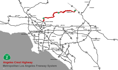
Angeles Crest Highway
Encyclopedia
La Cañada Flintridge, California
La Cañada Flintridge is a small and affluent city in Los Angeles County, California, United States whose population at the 2010 census was 20,246, down from 20,318 at the 2000 census. According to Forbes, as of 2010, La Cañada Flintridge ranks as the 143rd most expensive U.S...
and its eastern terminus at State Route 138
California State Route 138
State Route 138 is an east–west state highway generally following the northern foothills of the San Gabriel Mountains of southern California, USA from its junction with Interstate 5 south of Gorman eastward to Mount Anderson Junction, its eastern junction with State Route 18 south of...
northeast of Wrightwood
Wrightwood, California
Wrightwood is a census-designated place in San Bernardino County, California. It sits at an elevation of . The population was 4,525 at the 2010 census.-History:...
. The majority of the route passes through the mountainous terrain located north of the Los Angeles
Los Ángeles
Los Ángeles is the capital of the province of Biobío, in the commune of the same name, in Region VIII , in the center-south of Chile. It is located between the Laja and Biobío rivers. The population is 123,445 inhabitants...
basin. Its alignment passes through the Angeles National Forest
Angeles National Forest
The Angeles National Forest of the U.S. National Forest Service is located in the San Gabriel Mountains of Los Angeles County, southern California. It was established on July 1, 1908, incorporating the first San Bernardino National Forest and parts of the former Santa Barbara and San Gabriel...
in the San Gabriel Mountains
San Gabriel Mountains
The San Gabriel Mountains Range is located in northern Los Angeles County and western San Bernardino County, California, United States. The mountain range lies between the Los Angeles Basin and the Mojave Desert, with Interstate 5 to the west and Interstate 15 to the east...
. Segments of the road reach altitudes above 7000 feet (2,133.6 m), with a summit of 7903 feet (2,408.8 m) at the Dawson Saddle
Mountain pass
A mountain pass is a route through a mountain range or over a ridge. If following the lowest possible route, a pass is locally the highest point on that route...
, which makes this road one of the highest in Southern California.
Route description
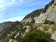
The route is best described as mountain-rural. Because the route passes through the protected Angeles National Forest, development is very limited. There are not many buildings between La Cañada Flintridge and Wrightwood save for Newcomb's RanchNewcomb's Ranch
Newcomb's Ranch is a roadhouse at in elevation in the Angeles National Forest, near Los Angeles, California. It is the only private property along the Angeles Crest Highway and is very popular with motorcyclists and is called "the informal headquarters for riders" by the Los Angeles Magazine and...
, campgrounds, and visitor center
Visitor center
A visitor center or centre , visitor information center, tourist information center, is a physical location that provides tourist information to the visitors who tour the place or area locally...
s. Other points of interest along the route include Mountain High
Mountain High
Mountain High resort is a winter resort in the San Gabriel Mountains in Los Angeles County in California. Mountain High is the most-visited resort in Southern California. The resort is located along State Route 2 west of Wrightwood, California...
and Mt. Waterman ski areas and Mount Wilson
Mount Wilson (California)
Mount Wilson is one of the better known peaks in the San Gabriel Mountains, part of the Angeles National Forest in Los Angeles County, California. It is the location of the Mount Wilson Observatory and has become the astronomical center of Southern California with and telescopes, and and tall...
(and its corresponding observatory
Mount Wilson Observatory
The Mount Wilson Observatory is an astronomical observatory in Los Angeles County, California, United States. The MWO is located on Mount Wilson, a 5,715 foot peak in the San Gabriel Mountains near Pasadena, northeast of Los Angeles...
and various radio/television transmitters). Depending on the local weather, i.e. no clouds or fog, impressive views of the Los Angeles basin are possible from the vicinity of Mount Wilson - the most significant limit of what can be seen is the density of the smog and/or marine layer
Marine layer
A marine layer is an air mass which develops over the surface of a large body of water such as the ocean or large lake in the presence of a temperature inversion. The inversion itself is usually initiated by the cooling effect of the water on the surface layer of an otherwise warm air mass...
covering the basin.
Angeles Forest Highway
The Angeles Forest Highway traverses the Angeles National Forest and connects the Los Angeles basin to the Antelope Valley by going up and over the San Gabriel Mountains. The highway is variously known as County Road N-3 or FH-59 or the Palmdale cutoff. It is about long...
, is heavily travelled by southbound traffic in the morning (and corresponding northbound traffic in the afternoon) that comprises commuters who live in the Antelope Valley
Antelope Valley
The Antelope Valley in California, United States, is located in northern Los Angeles County and the southeastern portion of Kern County, California, and constitutes the western tip of the Mojave Desert...
and work in the Greater Los Angeles area
Greater Los Angeles Area
The Greater Los Angeles Area, or the Southland, is a term used for the Combined Statistical Area sprawled over five counties in the southern part of California, namely Los Angeles County, Orange County, San Bernardino County, Riverside County and Ventura County...
. The route is a convenient alternative to the Antelope Valley Freeway (State Route 14
California State Route 14
State Route 14 is a north–south state highway in the U.S. state of California, largely in the Mojave Desert. The southern portion of the highway is signed as the Antelope Valley Freeway. The route connects Interstate 5, or Golden State Freeway, near Santa Clarita and with U.S. Route 395 near...
) and the Golden State Freeway (Interstate 5), both located to the west, to reach the Foothill Freeway (Interstate 210
Interstate 210 (California)
Interstate 210 and State Route 210 together form a contiguous highway, called the Foothill Freeway, in the Greater Los Angeles area of the U.S. state of California. The western portion of the route is an auxiliary Interstate Highway, while the eastern portion is a state highway...
). Because the road is a two-lane highway, its vehicle capacity is significantly lower than either of the two freeways.

Wrightwood, California
Wrightwood is a census-designated place in San Bernardino County, California. It sits at an elevation of . The population was 4,525 at the 2010 census.-History:...
.
History

Firebreak
A firebreak is a gap in vegetation or other combustible material that acts as a barrier to slow or stop the progress of a bushfire or wildfire. A firebreak may occur naturally where there is a lack of vegetation or "fuel", such as a river, lake or canyon...
. In 1941 construction stopped because of World War II
World War II
World War II, or the Second World War , was a global conflict lasting from 1939 to 1945, involving most of the world's nations—including all of the great powers—eventually forming two opposing military alliances: the Allies and the Axis...
. In 1946, after the war, construction resumed; the completed highway eventually opened in 1956. The road was constructed by prison labor staying at Camp 37. Camp 37 has since been razed. Division of Highways (now known as CalTrans) staff lived at a site called Cedar Springs. The staff is now located at Chilao Flats. The children attended Chilao Mountain School, a one room school. The school has been closed for several years.
Roads in the San Gabriel Mountains have a high number of single-vehicle auto and motorcycle accidents. As an example, in the predawn hours of December 8, 2004, a van plunged off the side of Angeles Forest Highway at about 1 miles (1.6 km) north of its junction with the Angeles Crest Highway, killing 3 of the 10 people in the van. The van was a carpool
Carpool
Carpooling , is the sharing of car journeys so that more than one person travels in a car....
carrying workers of the Jet Propulsion Laboratory
Jet Propulsion Laboratory
Jet Propulsion Laboratory is a federally funded research and development center and NASA field center located in the San Gabriel Valley area of Los Angeles County, California, United States. The facility is headquartered in the city of Pasadena on the border of La Cañada Flintridge and Pasadena...
from the Antelope Valley
Antelope Valley
The Antelope Valley in California, United States, is located in northern Los Angeles County and the southeastern portion of Kern County, California, and constitutes the western tip of the Mojave Desert...
to work in Pasadena. It was determined upon investigation by the CHP
California Highway Patrol
The California Highway Patrol is a law enforcement agency of the U.S. state of California. The CHP has patrol jurisdiction over all California highways and also acts as the state police....
that the driver fell asleep at the wheel of the van. The Angeles Crest Highway and Angeles Forest Highway have figured in various murders, not as scenes of the murder but as drop off points for the dead victims, including Linda Sobek, a model kidnapped and found dead in the area in 1995.
The motion picture Donnie Darko
Donnie Darko
Donnie Darko is a 2001 American psychological thriller film written and directed by Richard Kelly and starring Jake Gyllenhaal, Drew Barrymore, Patrick Swayze, Maggie Gyllenhaal, Noah Wyle, Jena Malone, and Mary McDonnell...
, released in 2001, was partially filmed on Angeles Crest Highway. In the opening scene with Donnie waking up in the middle of the road, next to his bike, the camera zooms in on Donnie, then loops around and shows a view of the valley seen from Angeles Crest Highway. The highway is also used later in the movie for other scenes. The Angeles Crest Highway is also used extensively in the motion picture The Love Bug
The Love Bug
The Love Bug is the first in a series of comedy films made by Walt Disney Productions that starred an anthropomorphic pearl-white, fabric-sunroofed 1963 Volkswagen racing Beetle named Herbie...
for racing scenes, as well as in the sequel film Herbie Goes to Monte Carlo
Herbie Goes to Monte Carlo
Herbie Goes to Monte Carlo is a 1977 film, the third of a series of films by Walt Disney Productions starring Herbie – the white Volkswagen racing Beetle with a mind of its own.-Plot:...
, where the highway doubles for "The French Alps".
Access and closures
Intersections with other roads are few which can be problematic in the event of road closures due to acts of nature such as landslides and fires. At about the midpoint of the highway is the junction with the north terminus of State Route 39California State Route 39
State Route 39 is a state highway in the U.S. state of California that travels through Orange and Los Angeles counties. Its southern terminus is at Pacific Coast Highway , in Huntington Beach, and its northern terminus is at Islip Saddle on Angeles Crest Highway in the Angeles National...
. However, access to State Route 39 is not possible as it is closed indefinitely to automobile traffic because of persistent landslides along its route. Therefore, travelers to the Angeles National Forest
Angeles National Forest
The Angeles National Forest of the U.S. National Forest Service is located in the San Gabriel Mountains of Los Angeles County, southern California. It was established on July 1, 1908, incorporating the first San Bernardino National Forest and parts of the former Santa Barbara and San Gabriel...
preferring the Angeles Crest Highway corridor should expect to be on the Angeles Crest Highway throughout much of its length, use available alternate routing where possible, or be willing to turn around and retrace their trip at any point along its route if necessary.
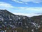
The Angeles Crest Highway is normally closed in the wintertime from Islip Saddle to Vincent Gap due to rockfall and avalanche hazards.
The winter storms of 2004-05 caused several landslides and significant damage to the highway. Thus, the highway never reopened in the summer of 2005. Damage to the highway was estimated to be over 4 million dollars as of November 2005. Terri Kasinga, a spokeswoman for the California Department of Transportation, stated in November 2005 "It is definitely not going to open until next spring (of 2006)". However, a March 2006 storm caused even more extensive damage to the highway including a complete washout of a large section of roadway, further delaying the reopening of the highway. The long closure caused concern for the United States Forest Service and other emergency services agencies because it hindered access, particularly with firefighting efforts, and it hurt business in Wrightwood. After a four and a half year closure, the highway reopened on May 20, 2009. Repairs included the construction of a new bridge intended to allow landslides to pass underneath without damaging the road. The work cost $10.5 million.
A moratorium on three-axles trucks was imposed in 2009 following the deaths of two people when a tractor trailer lost control and crashed into La Cañada businesses.
Cell phone reception
Telecommunication
Telecommunication is the transmission of information over significant distances to communicate. In earlier times, telecommunications involved the use of visual signals, such as beacons, smoke signals, semaphore telegraphs, signal flags, and optical heliographs, or audio messages via coded...
can be sporadic and, when available, signal strength and clarity is poor. Although the surrounding mountainous terrain is the primary reason for this, the limited presence of, and/or proximity to, cellular communication antennas to receive and transmit signals along the route contributes to the problem.
The Federal Lands Recreation Enhancement Act passed in December 2004, protects the Angeles National Forest. Although anyone can park at the side of the road and access the wilderness
Wilderness
Wilderness or wildland is a natural environment on Earth that has not been significantly modified by human activity. It may also be defined as: "The most intact, undisturbed wild natural areas left on our planet—those last truly wild places that humans do not control and have not developed with...
along the side of the road, doing so for extended periods of time, such as camping or hiking, requires a National Forest
United States National Forest
National Forest is a classification of federal lands in the United States.National Forests are largely forest and woodland areas owned by the federal government and managed by the United States Forest Service, part of the United States Department of Agriculture. Land management of these areas...
Adventure Pass
National Forest Adventure Pass
The National Forest Adventure Pass is a recreation fee pass issued by the United States Forest Service that permits bearers in the four National Forests in Southern California to park their cars for the purpose of recreation...
available for a $5.00 fee.
2009 Station Fire closure
During the 2009 wildfire season the large fire known as the "Station Fire" burned the mountains through which Route 2 travels. The fire damaged the signs, guardrails, and lane striping, as well as leaving large boulders and other debris all over the road. As a result, the highway was closed by Caltrans until November 30, 2009. It was briefly re-opened until mud and rock slides in early 2010 forced a portion of the highway to be closed again from 2 miles east of the I-210 junction to 14 miles east of La Canada. It reopened on June 3, 2011.Angeles Crest Freeway
Angeles Crest Highway was originally planned to be upgraded to a freeway in the 1950s, but was later considered geographically improbable and the plans were abandoned.External links
- Current road closures along Angeles Crest Highway (from Caltrans)
- March 2006 Storm Damage Photos
- Angeles National Forest website
- Story on van crash at WikinewsWikinewsWikinews is a free-content news source wiki and a project of the Wikimedia Foundation. The site works through collaborative journalism. Wikipedia co-founder Jimmy Wales has distinguished Wikinews from Wikipedia by saying "on Wikinews, each story is to be written as a news story as opposed to an...
- Charges dismissed in JPL van accident
- Geocities page on Angeles Crest Highway (Archived 2009-10-25)
- Angeles Crest Highway
- Angeles Crest Highway (SR2) Road Guide
- Motorcycle Classics article on riding the Angeles Crest Highway to Newcomb's Ranch