

Los Angeles Flood of 1938
Encyclopedia
The Los Angeles Flood of 1938 or 1938 Los Angeles flood was a major flooding event that was responsible for inundating much of Los Angeles, Orange
, and Riverside counties, California
, during early 1938. The flood was caused by a pair of oceanic storms that swept inland across the Los Angeles Basin
in February and March 1938, causing abnormal rainfall across much of coastal Southern California. 113 to 115 people perished in the flood, which was one of the most catastrophic disasters in area history. The flood caused the destruction of roads, bridges, and buildings, stranded hundreds of people, and resulted in the flooding of three area rivers and their tributaries; these were the Santa Ana
, Los Angeles
, and San Gabriel
. Despite the extent of the disaster, however, its effects were moderated by existing placements of flood control features in the San Gabriel Mountains
; it is said that the damage would have been far worse if there were no flood control measures in place at all.
The flooding event of 1938 was, however, considered a 50-year flood, meaning that it has a 2 percent chance of occurring any given year. The flood resulted in $40 million of damages, and was said by the Red Cross to be the "fifth largest flood in history". It heavily affected public opinion on the safety of area rivers, and as a result, the U.S. Army Corps of Engineers was prompted to begin channelization of the river, and construction of more flood control dams. Dams built in the aftermath of the flood include Sepulveda Dam
, Hansen Dam
, and Whittier Narrows Dam
, which hydrologically connects the San Gabriel River
to the Rio Hondo
. The channelization, however, does not remove all dangers of floods; there were major floods in 1969, 1980, 1983, 1992, and 1994, with the last said to probably be a 100 year flood.
 Between February 27 and 28, 1938, a storm from the Pacific Ocean
moved inland into the Los Angeles Basin, where its contents were stopped from progressing eastward by the San Gabriel Mountains
. As the storm could progress no further, the area received almost constant rain on February 27, February 28, and early March 1, 1938, when it finally abated and began to clear. A total of 4.4 inches (11.2 cm) of rain had fallen thus far, and the storm had formed comparatively minor flooding that had flooded only a few buildings in the low-lying areas of the Los Angeles Basin.
Fifteen hours later on March 1, at approximately 8:45 PM, the second storm entered the basin, creating gale-force winds along the coast and pouring even more rain into the region. Resultantly, the rains added more than 5 inches (12.7 cm) to the total rainfall amount. The storm ended on March 3, but damages remained huge.
. The general hospital of Los Angeles County was threatened by rising floodwaters, which had inundated the hospital power generator.
More than 20 structures were destroyed in the Arroyo Seco
canyon, but there were no fatalities there.
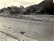
 Damage was probably most severe along the Santa Ana River
in San Bernardino, Riverside and Orange Counties further south. Without any flood control dams, the river swelled to over 317000 cuft/s, almost half the flow of the Mississippi River
. The flooding was so intense that it transformed most of low-lying northwestern Riverside County and northern Orange County into a large lake. The town of Agua Mansa, with a population of over 200, was completely swept away. The cities of Anaheim and Santa Ana, further downstream in Orange County, were covered with up to 6 feet (1.8 m) of water.
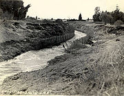
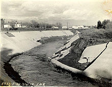
The Los Angeles River
reached a maximum flood stage of 130000 ft3 per second. The Tujunga Wash
reached its peak on March 3, 1938, with a water flow of an estimated 50000 ft3 per second, only after the Big Tujunga Dam
had begun emergency spillway releases. The floodwaters swept through incomplete Hansen Dam
, escaped the normal channel of Tujunga Creek and flowed from Van Nuys to Lankershim Boulevard
and directly into the Los Angeles River.
The San Gabriel River
, however, was very much moderated by the extensive series of flood control dams it harbored. Releases from the San Gabriel Dam Number Two (Cogswell Dam
) and the East Fork San Gabriel River joined to produce a flow of 100000 ft3 per second, which all flowed into the reservoir of San Gabriel Dam Number One (San Gabriel Dam
). As it filled to capacity, releases of up to 60000 ft3 per second occurred from No. 1 into the reservoir of Morris Dam
, further down on the river.
 Many people were marooned in the San Gabriel Mountains
following the storms, as severe mudslides and flooding prevented their escape. It was said that all roads leading into the mountains had been washed out in some way and notably, Big Tujunga Canyon was "all but swept clean of structures that were not up above the flood line".
It was found that the Big Tujunga Dam had actually prevented Big Tujunga Wash water from flowing excessively into the Los Angeles River. It was said that "Were it not for the Big Tujunga Dam, which finally filled to capacity and began spilling, the flood on the Los Angeles River would have been much worse than it already was."
Los Angeles County was not the most affected by the floods; Riverside and Orange "took the brunt of the waters" like "gargantuan saucers". (Los Angeles Times, 1938.) At the time, Los Angeles county was the most populous of the three; Orange and Riverside were mostly farming and ranching regions. Therefore, many people were spared by the distribution of floodwaters.
chartered a United Air Lines Mainliner to provide them an aerial view of flooding damage. The reporter was said to comment that "Disaster, gutted farmlands, ruined roads, shattered communications, wrecked railroad lines—all leap into sharp-etched reality from that altitude." The Los Angeles River also was not the most affected watershed; the Santa Ana River, at twice its length, was famously commented on as being "swollen crazy-mad".
Orange County, California
Orange County is a county in the U.S. state of California. Its county seat is Santa Ana. As of the 2010 census, its population was 3,010,232, up from 2,846,293 at the 2000 census, making it the third most populous county in California, behind Los Angeles County and San Diego County...
, and Riverside counties, California
California
California is a state located on the West Coast of the United States. It is by far the most populous U.S. state, and the third-largest by land area...
, during early 1938. The flood was caused by a pair of oceanic storms that swept inland across the Los Angeles Basin
Los Angeles Basin
The Los Angeles Basin is the coastal sediment-filled plain located between the Peninsular and Transverse ranges in southern California in the United States containing the central part of the city of Los Angeles as well as its southern and southeastern suburbs...
in February and March 1938, causing abnormal rainfall across much of coastal Southern California. 113 to 115 people perished in the flood, which was one of the most catastrophic disasters in area history. The flood caused the destruction of roads, bridges, and buildings, stranded hundreds of people, and resulted in the flooding of three area rivers and their tributaries; these were the Santa Ana
Santa Ana River
The Santa Ana River is the largest river of Southern California in the United States. Its drainage basin spans four counties. It rises in the San Bernardino Mountains and flows past the cities of San Bernardino and Riverside, before cutting through the northern tip of the Santa Ana Mountains and...
, Los Angeles
Los Angeles River
The Los Angeles River is a river that starts in the San Fernando Valley, in the Simi Hills and Santa Susana Mountains, and flows through Los Angeles County, California, from Canoga Park in the western end of the San Fernando Valley, nearly southeast to its mouth in Long Beach...
, and San Gabriel
San Gabriel River (California)
The San Gabriel River flows through southern Los Angeles County, California in the United States. Its main stem is about long, while its farthest tributaries extend almost altogether...
. Despite the extent of the disaster, however, its effects were moderated by existing placements of flood control features in the San Gabriel Mountains
San Gabriel Mountains
The San Gabriel Mountains Range is located in northern Los Angeles County and western San Bernardino County, California, United States. The mountain range lies between the Los Angeles Basin and the Mojave Desert, with Interstate 5 to the west and Interstate 15 to the east...
; it is said that the damage would have been far worse if there were no flood control measures in place at all.
The flooding event of 1938 was, however, considered a 50-year flood, meaning that it has a 2 percent chance of occurring any given year. The flood resulted in $40 million of damages, and was said by the Red Cross to be the "fifth largest flood in history". It heavily affected public opinion on the safety of area rivers, and as a result, the U.S. Army Corps of Engineers was prompted to begin channelization of the river, and construction of more flood control dams. Dams built in the aftermath of the flood include Sepulveda Dam
Sepulveda Dam
Located in Los Angeles, California, the Sepulveda Dam is a project of the U.S. Army Corps of Engineers, built in 1941 to withhold winter flood waters along the Los Angeles River...
, Hansen Dam
Hansen Dam
Hansen Dam is a dam in Lake View Terrace, Los Angeles, California. It was built in 1940 by the U.S. Army Corps of Engineers, Los Angeles District...
, and Whittier Narrows Dam
Whittier Narrows Dam
Whittier Narrows Dam is a dam on the San Gabriel River in Montebello, California. Built by the U.S. Army Corps of Engineers for flood control, it is a 17 m tall earth dam. Construction of the dam was completed in 1957. Its reservoir has a capacity of .-External links:*...
, which hydrologically connects the San Gabriel River
San Gabriel River (California)
The San Gabriel River flows through southern Los Angeles County, California in the United States. Its main stem is about long, while its farthest tributaries extend almost altogether...
to the Rio Hondo
Rio Hondo
Río Hondo or Hondo River may refer to:*Río Hondo, Zacapa, a municipality in the Guatemalan department of Zacapa*Rio Hondo , a river which forms much of the border between Belize and Mexico...
. The channelization, however, does not remove all dangers of floods; there were major floods in 1969, 1980, 1983, 1992, and 1994, with the last said to probably be a 100 year flood.
Background
Pacific Ocean
The Pacific Ocean is the largest of the Earth's oceanic divisions. It extends from the Arctic in the north to the Southern Ocean in the south, bounded by Asia and Australia in the west, and the Americas in the east.At 165.2 million square kilometres in area, this largest division of the World...
moved inland into the Los Angeles Basin, where its contents were stopped from progressing eastward by the San Gabriel Mountains
San Gabriel Mountains
The San Gabriel Mountains Range is located in northern Los Angeles County and western San Bernardino County, California, United States. The mountain range lies between the Los Angeles Basin and the Mojave Desert, with Interstate 5 to the west and Interstate 15 to the east...
. As the storm could progress no further, the area received almost constant rain on February 27, February 28, and early March 1, 1938, when it finally abated and began to clear. A total of 4.4 inches (11.2 cm) of rain had fallen thus far, and the storm had formed comparatively minor flooding that had flooded only a few buildings in the low-lying areas of the Los Angeles Basin.
Fifteen hours later on March 1, at approximately 8:45 PM, the second storm entered the basin, creating gale-force winds along the coast and pouring even more rain into the region. Resultantly, the rains added more than 5 inches (12.7 cm) to the total rainfall amount. The storm ended on March 3, but damages remained huge.
Flooding effects
Overall, the flood of 1938 was responsible for destroying 5,601 houses, damaging a further 1,500, killing upwards of 110 people, and stranding over 800 cars. Heavy silt content in floods buried roads and streets in the area, stopping traffic for many days. The Little Rock Dam in the northern San Gabriel Mountains on Little Rock Creek nearly collapsed during the flood, while another dam in Pickens Canyon produced such large flood releases that it inundated the Roosevelt district of LancasterLancaster, California
Lancaster is a charter city in northern Los Angeles County, in the high desert, near the Kern County line. Lancaster currently ranks as the 30th largest city in California, and the 148th largest city in the United States. Lancaster is the principal city within the Antelope Valley...
. The general hospital of Los Angeles County was threatened by rising floodwaters, which had inundated the hospital power generator.
More than 20 structures were destroyed in the Arroyo Seco
Arroyo Seco (Los Angeles County)
The Arroyo Seco, meaning "dry stream" in Spanish, is a seasonal river, canyon, watershed, and cultural area in Los Angeles County, California, United States. The Arroyo Seco has been called the most celebrated canyon in Southern California.-River course:...
canyon, but there were no fatalities there.
Santa Ana River
The Santa Ana River is the largest river of Southern California in the United States. Its drainage basin spans four counties. It rises in the San Bernardino Mountains and flows past the cities of San Bernardino and Riverside, before cutting through the northern tip of the Santa Ana Mountains and...
in San Bernardino, Riverside and Orange Counties further south. Without any flood control dams, the river swelled to over 317000 cuft/s, almost half the flow of the Mississippi River
Mississippi River
The Mississippi River is the largest river system in North America. Flowing entirely in the United States, this river rises in western Minnesota and meanders slowly southwards for to the Mississippi River Delta at the Gulf of Mexico. With its many tributaries, the Mississippi's watershed drains...
. The flooding was so intense that it transformed most of low-lying northwestern Riverside County and northern Orange County into a large lake. The town of Agua Mansa, with a population of over 200, was completely swept away. The cities of Anaheim and Santa Ana, further downstream in Orange County, were covered with up to 6 feet (1.8 m) of water.
The Los Angeles River
Los Angeles River
The Los Angeles River is a river that starts in the San Fernando Valley, in the Simi Hills and Santa Susana Mountains, and flows through Los Angeles County, California, from Canoga Park in the western end of the San Fernando Valley, nearly southeast to its mouth in Long Beach...
reached a maximum flood stage of 130000 ft3 per second. The Tujunga Wash
Tujunga Wash
Tujunga Wash is a stream in Los Angeles County, California. It is a tributary of the Los Angeles River, providing about a fifth of its flow, and drains about...
reached its peak on March 3, 1938, with a water flow of an estimated 50000 ft3 per second, only after the Big Tujunga Dam
Big Tujunga Dam
Big Tujunga Dam is a concrete arch dam in Los Angeles County, California, spanning Big Tujunga Creek northeast of Sunland. Completed in 1931 by the Los Angeles Department of Water and Power, it serves mainly for flood control. The dam was originally planned as one of several similar flood-control...
had begun emergency spillway releases. The floodwaters swept through incomplete Hansen Dam
Hansen Dam
Hansen Dam is a dam in Lake View Terrace, Los Angeles, California. It was built in 1940 by the U.S. Army Corps of Engineers, Los Angeles District...
, escaped the normal channel of Tujunga Creek and flowed from Van Nuys to Lankershim Boulevard
Lankershim Boulevard
-Geography:Lankershim Boulevard starts off at San Fernando Road in the Sun Valley portion of the San Fernando Valley. In addition to Sun Valley, it runs through North Hollywood and Universal City. It runs for about 7.3 miles before ending directly south of Ventura Boulevard...
and directly into the Los Angeles River.
The San Gabriel River
San Gabriel River (California)
The San Gabriel River flows through southern Los Angeles County, California in the United States. Its main stem is about long, while its farthest tributaries extend almost altogether...
, however, was very much moderated by the extensive series of flood control dams it harbored. Releases from the San Gabriel Dam Number Two (Cogswell Dam
Cogswell Dam
Cogswell Dam is a rockfill dam on the West Fork of the San Gabriel River in Los Angeles County, California. It forms Cogswell Reservoir, which has a capacity of with an average storage of , and serves mainly for flood control in conjunction with San Gabriel and Morris Dams downstream....
) and the East Fork San Gabriel River joined to produce a flow of 100000 ft3 per second, which all flowed into the reservoir of San Gabriel Dam Number One (San Gabriel Dam
San Gabriel Dam
San Gabriel Dam is a rockfill dam on the San Gabriel River in the San Gabriel Mountains, in Los Angeles County, California, within the Angeles National Forest...
). As it filled to capacity, releases of up to 60000 ft3 per second occurred from No. 1 into the reservoir of Morris Dam
Morris Dam
Morris Dam is a concrete gravity dam across the San Gabriel River in the U.S. state of California. The dam was built in the 1930s as a water supply facility for the city of Pasadena, but is now mostly utilized for flood control and flow regulation for groundwater recharge...
, further down on the river.
Aftermath
San Gabriel Mountains
The San Gabriel Mountains Range is located in northern Los Angeles County and western San Bernardino County, California, United States. The mountain range lies between the Los Angeles Basin and the Mojave Desert, with Interstate 5 to the west and Interstate 15 to the east...
following the storms, as severe mudslides and flooding prevented their escape. It was said that all roads leading into the mountains had been washed out in some way and notably, Big Tujunga Canyon was "all but swept clean of structures that were not up above the flood line".
It was found that the Big Tujunga Dam had actually prevented Big Tujunga Wash water from flowing excessively into the Los Angeles River. It was said that "Were it not for the Big Tujunga Dam, which finally filled to capacity and began spilling, the flood on the Los Angeles River would have been much worse than it already was."
Los Angeles County was not the most affected by the floods; Riverside and Orange "took the brunt of the waters" like "gargantuan saucers". (Los Angeles Times, 1938.) At the time, Los Angeles county was the most populous of the three; Orange and Riverside were mostly farming and ranching regions. Therefore, many people were spared by the distribution of floodwaters.
Media and news attention
The Los Angeles TimesLos Angeles Times
The Los Angeles Times is a daily newspaper published in Los Angeles, California, since 1881. It was the second-largest metropolitan newspaper in circulation in the United States in 2008 and the fourth most widely distributed newspaper in the country....
chartered a United Air Lines Mainliner to provide them an aerial view of flooding damage. The reporter was said to comment that "Disaster, gutted farmlands, ruined roads, shattered communications, wrecked railroad lines—all leap into sharp-etched reality from that altitude." The Los Angeles River also was not the most affected watershed; the Santa Ana River, at twice its length, was famously commented on as being "swollen crazy-mad".
External links
- Image Gallery of 1962, 1941, 1938 Los Angeles floods
- http://www.semp.us/biots/biot_369.html