
Rock formations in the United States
Encyclopedia
The following is a partial list of rock formation
s in the United States
, by state:
Arizona
California

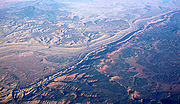
Colorado
Hawaii
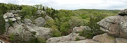
Illinois
Indiana
Kansas
Massachusetts
Minnesota
Montana
Nebraska
Nevada
New Mexico
New York
Oregon
Tennessee
Texas
Utah
West Virginia
Wisconsin
Wyoming
Rock formation
This is a list of rock formations that include isolated, scenic, or spectacular surface rock outcrops. These formations are usually the result of weathering and erosion sculpting the existing rock...
s in the United States
United States
The United States of America is a federal constitutional republic comprising fifty states and a federal district...
, by state:
ArizonaArizonaArizona ; is a state located in the southwestern region of the United States. It is also part of the western United States and the mountain west. The capital and largest city is Phoenix...
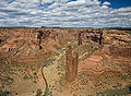
- Canyon de Chelly National MonumentCanyon de Chelly National MonumentCanyon de Chelly National Monument was established on April 1, 1931 as a unit of the National Park Service. It is located in northeastern Arizona within the boundaries of the Navajo Nation...
- Spider Rock
- Chiricahua National MonumentChiricahua National MonumentChiricahua National Monument is a unit of the National Park Service located in the Chiricahua Mountains. It is famous for its extensive vertical rock formations. The monument is located approximately southeast of Willcox, Arizona. It preserves the remains of an immense volcanic eruption that...
- Duck on a Rock
- Organ Pipe
- Mushroom Rock
- Sea Captain
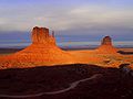
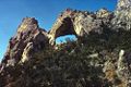
- Monument ValleyMonument ValleyMonument Valley is a region of the Colorado Plateau characterized by a cluster of vast sandstone buttes, the largest reaching above the valley floor. It is located on the northern border of Arizona with southern Utah , near the Four Corners area...
- Hunts MesaHunts MesaHunts Mesa is a rock formation located in Monument Valley, just south of the border between Utah and Arizona in the United States and just west of the border between Arizona's Navajo County and Apache County...
- Mittens
- North Window
- Three Sisters
- The Thumb
- Totem Pole
- Hunts Mesa
- Petrified Forest National ParkPetrified Forest National ParkPetrified Forest National Park is a United States national park in Navajo and Apache counties in northeastern Arizona. The park's headquarters are about east of Holbrook along Interstate 40 , which parallels a railroad line, the Puerco River, and historic U.S. Route 66, all crossing the park...
- Agate Bridge
- Window Rock
CaliforniaCaliforniaCalifornia is a state located on the West Coast of the United States. It is by far the most populous U.S. state, and the third-largest by land area...
- Alabama HillsAlabama HillsAlabama Hills are a "range of hills" and rock formations near the eastern slope of the Sierra Nevada Mountains in the Owens Valley, west of Lone Pine in Inyo County, California....
- Bird RockBird Rock (Marin County, California)Bird Rock is a rock formation and a small Pacific island west of Tomales Point in Marin County, California at Its area is roughly .A seabird colony, the island is covered with a layer of guano...
- Castle CragsCastle CragsCastle Crags is a dramatic and well-known rock formation in Northern California. Although the mountains of Northern California consist largely of rocks of volcanic and sedimentary origin, granite bodies intruded many parts of the area during the Jurassic period...
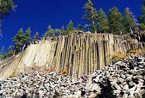
- Devil's Postpile
- Gull RockGull RockGull Rock is a rock formation and a small rocky island in Marin County, California, USA, in the Pacific Ocean just offshore of the Golden Gate National Recreation Area....
- Indian Rock, Indian Rock ParkIndian Rock ParkIndian Rock Park is a public park in the city of Berkeley, California, on the slope of the Berkeley Hills. It is located in the northeast part of the city, about one block north of the Arlington/Marin Circle, and straddles Indian Rock Avenue. The central feature of the park is a large rock...
- Moro RockMoro RockMoro Rock is a granite dome rock formation in Sequoia National Park, California, USA. It is located in the center of the park, at the head of Moro Creek, between Giant Forest and Crescent Meadow. A stairway, built in the 1930s by the Civilian Conservation Corps, is cut into and poured onto the...
, Sequoia National ParkSequoia National ParkSequoia National Park is a national park in the southern Sierra Nevada east of Visalia, California, in the United States. It was established on September 25, 1890. The park spans . Encompassing a vertical relief of nearly , the park contains among its natural resources the highest point in the... - Mussel RockMussel Rockright|thumb|Mussel Rock is a rock formation on the coast of San Mateo County, California, offshore from Daly City. It consists of one large and numerous smaller rocks of a type known as a stack, where a headland is eroded unevenly, leaving small islands....
- Nine SistersNine SistersThe Nine Sisters or the Morros are a chain of nine volcanic peaks and hills between Morro Bay and San Luis Obispo, California. They are popular with photographers and rock climbers. Their volcanic origin makes them of significant geological interest. They support a wide variety of plant, animal,...
(aka "The Morros"), San Luis Obispo - San Pedro RockSan Pedro RockSan Pedro Rock is a rock formation and small island off Point San Pedro in Pacifica, California, in the San Francisco Bay Area's San Mateo County.-See also:* List of islands of California...
- Seal Rock (San Francisco County, California)
- Seal Rock (San Mateo County, California)Seal Rock (San Mateo County, California)Seal Rock is a small island in San Mateo County, California.-See also:*List of islands of California...
- Sears RockSears RockSears Rock is a small rocky island in Marin County, California.-See also:* List of islands of California...
- Skull Rock, Joshua Tree National ParkJoshua Tree National ParkJoshua Tree National Park is located in southeastern California. Declared a U.S. National Park in 1994 when the U.S. Congress passed the California Desert Protection Act , it had previously been a U.S. National Monument since 1936. It is named for the Joshua tree forests native to the park...
- TahquitzTahquitzTahquitz is a granite rock formation located on the high western slope of the San Jacinto mountain range in Riverside County, Southern California, United States, above the mountain town of Idyllwild...
- Vasquez RocksVasquez RocksVasquez Rocks Natural Area Park is a 905-acre northern Los Angeles County, California, USA park acquired by the Los Angeles County government in the 1970s...
- Yosemite ValleyYosemite ValleyYosemite Valley is a glacial valley in Yosemite National Park in the western Sierra Nevada mountains of California, carved out by the Merced River. The valley is about long and up to a mile deep, surrounded by high granite summits such as Half Dome and El Capitan, and densely forested with pines...
/Yosemite National ParkYosemite National ParkYosemite National Park is a United States National Park spanning eastern portions of Tuolumne, Mariposa and Madera counties in east central California, United States. The park covers an area of and reaches across the western slopes of the Sierra Nevada mountain chain...
- Cathedral RocksCathedral RocksCathedral Rocks are a series of four abrupt cliffs interspersed by short glaciers and surmounted by sharp peaks. The cliffs extend for along the south side of Ferrar Glacier and form part of the north shoulder of the Royal Society Range, in Victoria Land. They were discovered and named on...
- Cathedral SpiresCathedral Spires"Cathedral Spires" is a song by English heavy metal band Judas Priest. It is the last track from their album Jugulator. Even though the album has received much criticism the song is widely regarded as a classic...
- Clouds RestClouds RestClouds Rest is a mountain in Yosemite National Park east northeast of Yosemite Village, California. Although there are many peaks in the park having far greater elevation, Clouds Rest's proximity to the valley gives it a very high degree of visual prominence....
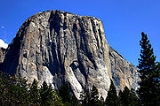
- El CapitanEl CapitanEl Capitan is a vertical rock formation in Yosemite National Park, located on the north side of Yosemite Valley, near its western end. The granite monolith extends about from base to summit along its tallest face, and is one of the world's favorite challenges for rock climbers.The formation was...
- Glacier PointGlacier Pointthumb|right|upright|Glacier Point, as seen from [[Yosemite Valley]]. In springtime, this cliff face is covered with dozens of freshets and tiny waterfalls from the snowmelt, the largest being [[Staircase Falls]]....
- Half DomeHalf DomeHalf Dome is a granite dome in Yosemite National Park, located in northeastern Mariposa County, California, at the eastern end of Yosemite Valley — possibly Yosemite's most familiar rock formation. The granite crest rises more than above the valley floor....
- Lembert DomeLembert DomeLembert Dome is a granite dome rock formation in Yosemite National Park in the U.S. state of California The dome soars above Tuolumne Meadows and the Tuolumne River and can be hiked starting at the Tioga Road in the heart of Tuolumne Meadows, west of the Tioga Pass Entrance to Yosemite National...
- Sentinel Rock
- Three BrothersThree Brothers (Yosemite)The Three Brothers is a rock formation, in Yosemite Valley, California, USA. It is located just east of El Capitan and consists of Eagle Peak , and Middle and Lower Brothers....
- Cathedral Rocks
ColoradoColoradoColorado is a U.S. state that encompasses much of the Rocky Mountains as well as the northeastern portion of the Colorado Plateau and the western edge of the Great Plains...
- Garden of the GodsGarden of the GodsGarden of the Gods is a public park located in Colorado Springs, Colorado, USA.-Genesis of the park:Entrance to the park is free according to the wish of Charles Elliott Perkins, whose children donated the land to the city of Colorado Springs in 1909....
, Colorado SpringsColorado Springs, ColoradoColorado Springs is a Home Rule Municipality that is the county seat and most populous city of El Paso County, Colorado, United States. Colorado Springs is located in South-Central Colorado, in the southern portion of the state. It is situated on Fountain Creek and is located south of the Colorado... - Painted Wall (Black Canyon of the Gunnison National ParkBlack Canyon of the Gunnison National Parkthumb|upright|Black Canyon of the GunnisonBlack Canyon of the Gunnison National Park is a United States National Park located in western Colorado, and managed by the National Park Service...
) - Red Rocks
HawaiiHawaiiHawaii is the newest of the 50 U.S. states , and is the only U.S. state made up entirely of islands. It is the northernmost island group in Polynesia, occupying most of an archipelago in the central Pacific Ocean, southwest of the continental United States, southeast of Japan, and northeast of...
- Iao Needle, MauiMauiThe island of Maui is the second-largest of the Hawaiian Islands at and is the 17th largest island in the United States. Maui is part of the state of Hawaii and is the largest of Maui County's four islands, bigger than Lānai, Kahoolawe, and Molokai. In 2010, Maui had a population of 144,444,...
- Gardner PinnaclesGardner PinnaclesThe Gardner Pinnacles are two barren rock outcrops surrounded by a reef and located in the Hawaiian Islands at , northwest of Honolulu and French Frigate Shoals. The total area of the two small islets—remnants of an ancient volcano—is . Its highest peak has a commanding height of 170...
, Northwestern Hawaiian IslandsNorthwestern Hawaiian IslandsThe Northwestern Hawaiian Islands or the Leeward Islands are the small islands and atolls in the Hawaiian island chain located northwest of the islands of Kauai and Niihau. They are administered by the U.S. state of Hawaii except Midway Atoll, which has temporary residential facilities and is...
IllinoisIllinoisIllinois is the fifth-most populous state of the United States of America, and is often noted for being a microcosm of the entire country. With Chicago in the northeast, small industrial cities and great agricultural productivity in central and northern Illinois, and natural resources like coal,...
- Garden of the Gods, Shawnee National ForestShawnee National ForestThe Shawnee National Forest, located in the Ozark and Shawnee Hills of Southern Illinois, consists of approximately 280,000 acres of federally managed lands. In descending order of land area it is located in parts of Pope, Jackson, Union, Hardin, Alexander, Saline, Gallatin, Johnson, and Massac...
IndianaIndianaIndiana is a US state, admitted to the United States as the 19th on December 11, 1816. It is located in the Midwestern United States and Great Lakes Region. With 6,483,802 residents, the state is ranked 15th in population and 16th in population density. Indiana is ranked 38th in land area and is...
- Devil's BackboneDevil's Backbone (rock formation)Devil's Backbone is a rock formation and peninsula formed by the flow of Fourteen Mile Creek into the Ohio River, and is currently situated in Charlestown State Park near Charlestown, Indiana...
, near CharlestownCharlestown, Indiana-Demographics:As of the census of 2000, there were 5,993 people, 2,341 households, and 1,615 families residing in the city. The population density was 2,570.0 people per square mile . There were 2,489 housing units at an average density of 1,067.4 per square mile...
KansasKansasKansas is a US state located in the Midwestern United States. It is named after the Kansas River which flows through it, which in turn was named after the Kansa Native American tribe, which inhabited the area. The tribe's name is often said to mean "people of the wind" or "people of the south...
- Mushroom Rock State ParkMushroom Rock State ParkMushroom Rock State Park, located in the Smoky Hills region of Kansas, is noted for its mushroom rock formations. These rocks were formed through a process of nonuniform erosion and weathering in which a hard mass of Dakota Sandstone resisted erosion while the underlying softer stone weathered...
, MarquetteMarquette, KansasMarquette is a city located in the northwest corner of McPherson County, Kansas, United States, between K-4 and the Smoky Hill River. The city was settled by Swedish immigrants and chartered on February 9, 1874... - Rock City
MassachusettsMassachusettsThe Commonwealth of Massachusetts is a state in the New England region of the northeastern United States of America. It is bordered by Rhode Island and Connecticut to the south, New York to the west, and Vermont and New Hampshire to the north; at its east lies the Atlantic Ocean. As of the 2010...
- Plymouth RockPlymouth RockPlymouth Rock is the traditional site of disembarkation of William Bradford and the Mayflower Pilgrims who founded Plymouth Colony in 1620. It is an important symbol in American history...
- Profile RockProfile RockProfile Rock, also known as the Old Man of Joshua's Mountain, is a 50-foot high granite rock formation located in Freetown, Massachusetts just outside Assonet village and near the Freetown State Forest....
, Freetown State Forest, AssonetAssonet, MassachusettsAssonet is one of two villages in the town of Freetown, Massachusetts in Bristol County, Massachusetts, United States. An original part of the town, Assonet was settled in 1659 along with the city of Fall River, then a part of Freetown. It rests on the banks of the Assonet River... - Mother AnnMother Ann (rock formation)Mother Ann is a rock formation located near the Eastern Point Lighthouse in Gloucester, Massachusetts. When viewed at the correct angle, the formation appears to be the silhouette of a reclining Puritan woman...
, GloucesterGloucester, MassachusettsGloucester is a city on Cape Ann in Essex County, Massachusetts, in the United States. It is part of Massachusetts' North Shore. The population was 28,789 at the 2010 U.S. Census...
MinnesotaMinnesotaMinnesota is a U.S. state located in the Midwestern United States. The twelfth largest state of the U.S., it is the twenty-first most populous, with 5.3 million residents. Minnesota was carved out of the eastern half of the Minnesota Territory and admitted to the Union as the thirty-second state...
- Devil's Kettle, Judge C. R. Magney State ParkJudge C. R. Magney State ParkJudge C. R. Magney State Park is a state park of Minnesota, USA, on the North Shore of Lake Superior. It was named for Clarence R. Magney, a former mayor of Duluth and judge on the Minnesota Supreme Court, who was instrumental in getting 11 state parks and scenic waysides established along the...
- In-Yan-Teopa, Frontenac State ParkFrontenac State ParkFrontenac State Park is a state park of Minnesota, USA, on the Mississippi River southeast of Red Wing. The park is notable both for its history and for its birdwatching opportunities. The centerpiece of the park is a , steep limestone bluff overlooking Lake Pepin, a natural widening of the...
- Palisade HeadPalisade HeadPalisade Head is a large rock formation on the North Shore of Lake Superior in the U.S. state of Minnesota. It is within Tettegouche State Park but not contiguous with the rest of that park...
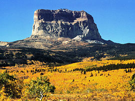
MontanaMontanaMontana is a state in the Western United States. The western third of Montana contains numerous mountain ranges. Smaller, "island ranges" are found in the central third of the state, for a total of 77 named ranges of the Rocky Mountains. This geographical fact is reflected in the state's name,...
- Glacier National Park
- Chief MountainChief MountainChief Mountain is located in the U.S. state of Montana on the eastern border of Glacier National Park and the Blackfeet Indian Reservation...
- Mount ClevelandMount Cleveland (Montana)Mount Cleveland is the highest mountain in Glacier National Park, located in Montana, United States. It is also the highest point in the Lewis Range, which spans part of the northern portion of the Park and extends into Canada...
- Mount GrinnellMount GrinnellMount Grinnell is a peak located in the heart of Glacier National Park in the U.S. state of Montana near Mount Gould and Mount Wilbur. It is named after George Bird Grinnell....
- Mount SiyehMount SiyehMount Siyeh, with a height of , is the fifth tallest and one of six peaks over in Glacier National Park, Montana, United States. Mount Siyeh was named after a Blackfoot Indian, Sai-yeh, whose name means "Crazy Dog" or "Mad Wolf."...
- Triple Divide PeakTriple Divide Peak (Montana)-See also:* Continental Divide of the Americas* Mountains and mountain ranges of Glacier National Park...
- Chief Mountain
- Pompeys Pillar National MonumentPompeys Pillar National MonumentPompeys Pillar National Monument is a rock formation located in south central Montana, United States. Designated a National Monument on January 17, 2001, and managed by the U.S. Bureau of Land Management, it consists of only , making it one of the smallest National Monuments in the U.S...
NebraskaNebraskaNebraska is a state on the Great Plains of the Midwestern United States. The state's capital is Lincoln and its largest city is Omaha, on the Missouri River....
- Chimney Rock National Historic SiteChimney Rock National Historic SiteChimney Rock is a prominent geological rock formation in Morrill County in western Nebraska. Rising nearly 300 feet above the surrounding North Platte River valley, the peak of Chimney Rock is above sea level. During the middle 19th century it served as a landmark along the Oregon Trail, the...
NevadaNevadaNevada is a state in the western, mountain west, and southwestern regions of the United States. With an area of and a population of about 2.7 million, it is the 7th-largest and 35th-most populous state. Over two-thirds of Nevada's people live in the Las Vegas metropolitan area, which contains its...
- Lexington Arch, Great Basin National ParkGreat Basin National ParkGreat Basin National Park is a United States National Park established in 1986, located in east-central Nevada near the Utah border. The park derives its name from the Great Basin, the dry and mountainous region between the Sierra Nevada and the Wasatch Mountains. Topographically, this area is...
- Red Rock Canyon National Conservation AreaRed Rock Canyon National Conservation AreaRed Rock Canyon National Conservation Area in Nevada is an area managed by the Bureau of Land Management as part of its National Landscape Conservation System, and protected as a National Conservation Area. It is located about west of Las Vegas, and easily seen from the Las Vegas Strip...
- Valley of FireValley of FireValley of Fire State Park is the oldest state park in Nevada, USA. It covers an area of and was dedicated in 1935. It derives its name from red sandstone formations, formed from great shifting sand dunes during the age of dinosaurs...
, Clark County, NevadaClark County, Nevada-Demographics:As of the census of 2000, there were 1,375,765 people, 512,253 households, and 339,693 families residing within the MSA. The racial makeup of the MSA was 71.6% White , 9.1% Black, 5.7% Asian, 0.8% American Indian and 12.8% of other or mixed race. 22.0% were Hispanic of any race...
- Elephant Rock
- Natural Arch (collapsed in 2010)
New MexicoNew MexicoNew Mexico is a state located in the southwest and western regions of the United States. New Mexico is also usually considered one of the Mountain States. With a population density of 16 per square mile, New Mexico is the sixth-most sparsely inhabited U.S...
- City of Rocks State Park, Grant CountyGrant County, New Mexico-2010:Whereas according to the 2010 U.S. Census Bureau:*84.9% White*0.9% Black*1.4% Native American*0.4% Asian*0.1% Native Hawaiian or Pacific Islander*2.8% Two or more races*9.8% Other races*48.3% Hispanic or Latino -2000:...
- Kneeling Nun, Hanover, Grant CountyGrant County, New Mexico-2010:Whereas according to the 2010 U.S. Census Bureau:*84.9% White*0.9% Black*1.4% Native American*0.4% Asian*0.1% Native Hawaiian or Pacific Islander*2.8% Two or more races*9.8% Other races*48.3% Hispanic or Latino -2000:...
- Natural Bridge, CoronaCorona, New MexicoCorona is a village in Lincoln County, New Mexico, United States, located on U.S. Route 54. The population was 165 at the 2000 census.Corona is the closest habitation to a purported UFO crash in 1947 about 30 miles to the southeast...
, Lincoln CountyLincoln County, New Mexico-2010:Whereas according to the 2010 U.S. Census Bureau:*85.1% White*0.5% Black*2.4% Native American*0.4% Asian*0.0% Native Hawaiian or Pacific Islander*2.5% Two or more races*9.1% Other races*29.8% Hispanic or Latino -2000:... - Needles Eye Arch and Little Needles Eye Arch, Florida MountainsFlorida MountainsThe Florida Mountains are a small 12-mi long, mountain range in New Mexico. The mountains lie in southern Luna County about 15 mi southeast of Deming, and 20 mi north of Chihuahua state, Mexico; the range lies in the north of the Chihuahuan Desert region, and extreme southwestern New...
, Luna CountyLuna County, New Mexico-2010:Whereas according to the 2010 U.S. Census Bureau:*77.7% White*1.1% Black*1.3% Native American*0.5% Asian*0.0% Native Hawaiian or Pacific Islander*2.6% Two or more races*16.8% Other races*61.5% Hispanic or Latino -2000:... - Saddle Rock, Grant CountyGrant County, New Mexico-2010:Whereas according to the 2010 U.S. Census Bureau:*84.9% White*0.9% Black*1.4% Native American*0.4% Asian*0.1% Native Hawaiian or Pacific Islander*2.8% Two or more races*9.8% Other races*48.3% Hispanic or Latino -2000:...
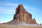
- ShiprockShiprockShiprock is a rock formation rising nearly above the high-desert plain on the Navajo Nation in San Juan County, New Mexico, USA. It has a peak elevation of above the sea level. It lies about southwest of the town of Shiprock, which is named for the peak...
- The Needles Eye, CooneyCooney, New MexicoCooney is a ghost town in Catron County, New Mexico, United States, east of Alma. Cooney was once home to gold and silver prospectors in the nearby Mogollon Mountains.-History:...
, Catron CountyCatron County, New Mexico-2010:Whereas according to the 2010 U.S. Census Bureau:*89.8% White*0.4% Black*2.7% Native American*0.2% Asian*0.0% Native Hawaiian or Pacific Islander*3.1% Two or more races*3.7% Other races*19.0% Hispanic or Latino -2000:...
New YorkNew YorkNew York is a state in the Northeastern region of the United States. It is the nation's third most populous state. New York is bordered by New Jersey and Pennsylvania to the south, and by Connecticut, Massachusetts and Vermont to the east...
- Lemon SqueezerLemon squeezer (rock formation)The Lemon Squeezer is an unusual rock formation in Harriman State Park, New York. It is located at the intersection of the Appalachian Trail and the Arden-Surebridge Trail , near the base of Island Pond Mountain in the town of Tuxedo....
, Harriman State Park - Rat RockRat RockRat Rock is a rock formation of a schist boulder protruding from the Central Park bedrock in Manhattan. It is named after the rats that used to swarm there at night but it is also known as Umpire Rock. It is near the southwest corner of the park, north of the Heckscher Ballfields on the lines of...
, Central ParkCentral ParkCentral Park is a public park in the center of Manhattan in New York City, United States. The park initially opened in 1857, on of city-owned land. In 1858, Frederick Law Olmsted and Calvert Vaux won a design competition to improve and expand the park with a plan they entitled the Greensward Plan...
, New York CityNew York CityNew York is the most populous city in the United States and the center of the New York Metropolitan Area, one of the most populous metropolitan areas in the world. New York exerts a significant impact upon global commerce, finance, media, art, fashion, research, technology, education, and... - Chimney Bluffs State ParkChimney Bluffs State ParkChimney Bluffs State Park is a state park in the town of Huron in Wayne County, New York on Lake Ontario, on the eastern shore of Sodus Bay. Using its hiking trails, the intrepid visitor can enjoy unique views of large clay rock formations at the water’s edge.The park has approximately four miles...
- The Palisades (Hudson River)
OregonOregonOregon is a state in the Pacific Northwest region of the United States. It is located on the Pacific coast, with Washington to the north, California to the south, Nevada on the southeast and Idaho to the east. The Columbia and Snake rivers delineate much of Oregon's northern and eastern...
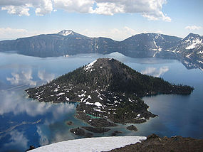
- Crater LakeCrater LakeCrater Lake is a caldera lake located in the south-central region of the U.S. state of Oregon. It is the main feature of Crater Lake National Park and famous for its deep blue color and water clarity. The lake partly fills a nearly deep caldera that was formed around 7,700 years agoby the...
- Phantom ShipPhantom ShipPhantom Ship is a small island in Crater Lake in the U.S. state of Oregon. It is a natural rock formation pillar which derives its name from its resemblance to a ghost ship, especially in foggy and low-light conditions....
- Wizard IslandWizard IslandWizard Island is a volcanic cinder cone which forms an island at the west end of Crater Lake in Crater Lake National Park, Oregon. The top of the island reaches above sea level, about above the average surface of the lake. The cone is capped by a volcanic crater about wide and deep. The...
- Phantom Ship
- Haystack RockHaystack RockHaystack Rock is a 235-foot sea stack in Cannon Beach, Oregon. It is sometimes claimed locally to be the third-tallest such "intertidal" structure in the world, but there are no scientific references to support this. A popular tourist destination, the monolithic rock is adjacent to the beach and...
, Clatsop CountyClatsop County, OregonClatsop County is a county located in the U.S. state of Oregon. The county is named for the Clatsop tribe of Native Americans, who lived along the coast of the Pacific Ocean prior to European settlement. As of 2010, the population was 37,039. The county seat is Astoria.-Economy:The principal... - The Honeycombs, Malheur CountyMalheur County, OregonMalheur County is a county located in the southeast corner of the U.S. state of Oregon. It is included in the eight-county definition of Eastern Oregon. Most of the county observes the Mountain Time Zone, although the southern quarter of the county observes the Pacific Time Zone along with the...
TennesseeTennesseeTennessee is a U.S. state located in the Southeastern United States. It has a population of 6,346,105, making it the nation's 17th-largest state by population, and covers , making it the 36th-largest by total land area...
- Rock CityRock CityRock City is a roadside attraction near Chattanooga, Tennessee, on Lookout Mountain in Lookout Mountain, Georgia, located near Ruby Falls. It is well-known for the many barn advertisements throughout the Southeast and Midwest United States that have the slogan "See Rock City" painted on barn roofs...
, ChattanoogaChattanooga, TennesseeChattanooga is the fourth-largest city in the US state of Tennessee , with a population of 169,887. It is the seat of Hamilton County... - Backbone Rock, Johnson County, Tennessee
- Tennessee arches/natural bridges and rock formations
TexasTexasTexas is the second largest U.S. state by both area and population, and the largest state by area in the contiguous United States.The name, based on the Caddo word "Tejas" meaning "friends" or "allies", was applied by the Spanish to the Caddo themselves and to the region of their settlement in...
- El Capitan, Guadalupe Mountains National ParkGuadalupe Mountains National ParkGuadalupe Mountains National Park is located in the Guadalupe Mountains of West Texas and contains Guadalupe Peak, the highest point in Texas at in elevation. It also contains El Capitan, long used as a landmark by people traveling along the old route later followed by the Butterfield Overland...
- Palo Duro CanyonPalo Duro CanyonPalo Duro Canyon is a canyon system of the Caprock Escarpment located in the Texas Panhandle near the city of Amarillo, Texas, United States. As the second largest canyon in the United States, it is roughly long and has an average width of , but reaches a width of at places. Its depth is around...
, Amarillo - Hueco TanksHueco TanksHueco Tanks is an area of low mountains in El Paso County, Texas, USA. It is located in a high-altitude desert basin between the Franklin Mountains to the west and the Hueco Mountains to the east. Hueco is a Spanish word meaning hollows and refers to the many water-holding depressions in the...
, Big Bend, Brewster CountyBrewster County, TexasBrewster County is a county located in western part of the US state of Texas, along the border with Mexico. It is one of the nine counties that comprise the Trans-Pecos region of West Texas. As of the 2000 census, the population is 8,866. In 2009, the population was estimated to be 9,481. Its... - Enchanted RockEnchanted RockEnchanted Rock is an enormous pink granite pluton rock formation located in the Llano Uplift approximately north of Fredericksburg, Texas, USA and south of Llano, Texas. Enchanted Rock State Natural Area, which includes Enchanted Rock and surrounding land, spans the border between Gillespie...
, Gillespie CountyGillespie County, TexasGillespie County is a county located on the Edwards Plateau in the U.S. state of Texas. In 2010, its population was 24,837. It is located in the heart of the Texas Hill Country. Gillespie is named for Robert Addison Gillespie, who came to Texas in 1837. He was a Texas Ranger, an Indian fighter, a...
/Llano CountyLlano County, TexasLlano County is a county located on the Edwards Plateau in the U.S. state of Texas. In 2010, its population was 19, 301. Its county seat is Llano, and the county is named for the Llano River....
UtahUtahUtah is a state in the Western United States. It was the 45th state to join the Union, on January 4, 1896. Approximately 80% of Utah's 2,763,885 people live along the Wasatch Front, centering on Salt Lake City. This leaves vast expanses of the state nearly uninhabited, making the population the...
- Arches National ParkArches National ParkArches National Park is a U.S. National Park in eastern Utah. It is known for preserving over 2000 natural sandstone arches, including the world-famous Delicate Arch, in addition to a variety of unique geological resources and formations....
- Balanced RockBalanced RockBalanced Rock is one of the most popular features of Arches National Park, situated in Grand County, Utah, United States. Balanced Rock is located next to the park's main road, at about 9 miles from the park entrance....
- Courthouse TowersCourthouse TowersThe Courthouse Towers is a collection of tall stone columns located in Arches National Park....
- Dark Angel
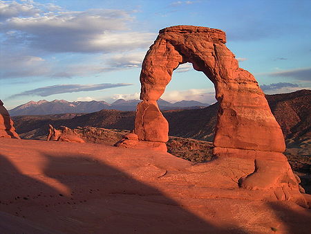
- Delicate ArchDelicate ArchDelicate Arch is a tall freestanding natural arch located in Arches National Park near Moab, Utah.It is the most widely-recognized landmark in Arches National Park and is depicted on Utah license plates and on a postage stamp commemorating Utah's centennial anniversary of statehood in 1996...
- Devil's GardenDevil's GardenDevil's Garden is an area of Arches National Park, located near Moab, Utah, that features a series of rock fins that have broken out of the earth due to erosion and produce many spectacular views...
- Double ArchDouble ArchDouble Arch is a close-set pair of natural arches, one of the more known features of Arches National Park in Utah, United States. From the Double Arch parking area it's a 0.5 mile round trip to the arches...
- Fiery Furnace
- Landscape ArchLandscape ArchLandscape Arch is the longest of the many natural rock arches located in the Arches National Park in Utah, USA. The arch is among many in the area known as Devil's Garden in the north area of the park...
- Petrified dunesPetrified dunesThe Petrified Dunes are a series of rock formations located in Arches National Park. The dunes can be found just off of the park road between the Courthouse Towers and the Windows Area. The formation was produced when ancient sand dunes hardened into stone under the overlying subsequent material,...
- Wall ArchWall ArchWall Arch was a natural sandstone arch in the Arches National Park in the U.S. state of Utah. Before its collapse in 2008, it was ranked 12th in size among the park's over 2,000 arches. At its largest, the opening underneath the span was wide by high. It consisted of Entrada Sandstone,...
(collapsed in 2008)
- Balanced Rock
- Bryce Canyon National ParkBryce Canyon National ParkBryce Canyon National Park is a national park located in southwestern Utah in the United States. The major feature of the park is Bryce Canyon which, despite its name, is not a canyon but a giant natural amphitheater created by erosion along the eastern side of the Paunsaugunt Plateau...
- Sinking Ship
- Thor's Hammer
- Canyonlands National ParkCanyonlands National ParkCanyonlands National Park is a U.S. National Park located in southeastern Utah near the town of Moab and preserves a colorful landscape eroded into countless canyons, mesas and buttes by the Colorado River, the Green River, and their respective tributaries. The park is divided into four districts:...
- Druid Arch
- Island in the Sky
- Mesa Arch
- Upheaval DomeUpheaval DomeUpheaval Dome is an impact structure, the deeply eroded remnants of an impact crater, in Canyonlands National Park near the town Moab, Utah, in the United States....
- Capitol Reef National ParkCapitol Reef National ParkCapitol Reef National Park is a United States National Park, in south-central Utah. It is 100 miles long but fairly narrow. The park, established in 1971, preserves 378 mi² and is open all year, although May through September are the most popular months.Called "Wayne Wonderland" in the 1920s...
- Capitol Dome
- Capitol Gorge
- Cassidy Arch
- The Castle
- Golden ThroneGolden Throne (mountain)The Golden Throne is a mountain located in Capitol Reef National Park, in Utah, United States. It is a rock formation dome made up of in a gold-stained Navajo Sandstone, which is particularly special because normally the sandstone is creamy white or red...
- Hickman Bridge
- Waterpocket FoldWaterpocket FoldThe Waterpocket Fold is a geologic landform that defines Capitol Reef National Park in the western United States. This monoclinal fold extends for slightly over 100 miles in the desert of central Utah. It can be seen via three scenic routes in the park. One route leads to a famous landmark known as...
- Dead Horse Point State ParkDead Horse Point State ParkDead Horse Point State Park is a state park of Utah, USA, featuring a dramatic overlook of the Colorado River and Canyonlands National Park. The park is so named because of its use as a natural corral by cowboys in the 19th century...
- Devil's SlideDevil's Slide (Utah)Devil's Slide is an unusual geological formation located in northern Utah's Weber Canyon, near the community of Croydon in Morgan County, Utah, United States. The slide consists of two parallel limestone strata that have been tilted to lie vertical, protruding out of the mountainside...
- Elephant RockKings Canyon (Utah)Kings Canyon is a canyon within the Confusion Range in Millard County, Utah. US Highway 6/US Highway 50 runs through the windy canyon. The area in and around the canyon is unpopulated, and is only used by humans for transportation and some sheep herding....
in Kings CanyonKings Canyon (Utah)Kings Canyon is a canyon within the Confusion Range in Millard County, Utah. US Highway 6/US Highway 50 runs through the windy canyon. The area in and around the canyon is unpopulated, and is only used by humans for transportation and some sheep herding....
, Millard County - Goblin Valley State ParkGoblin Valley State ParkGoblin Valley State Park is a state park of Utah, USA.Its eminent feature is its thousands of hoodoos and hoodoo rocks, which are formations of mushroom-shaped rock pinnacles, some as high as several meters...
- Natural Bridges National MonumentNatural Bridges National MonumentNatural Bridges National Monument is a U.S. National Monument located about north west of the Four Corners boundary of southeast Utah, in the western United States, at the junction of White Canyon and Armstrong Canyon, part of the Colorado River drainage...
- Kachina Natural Bridge
- Owachomo Natural Bridge
- Sipapu Natural BridgeSipapu Natural BridgeSipapu Bridge is a natural bridge or arch located in the Natural Bridges National Monument in the U.S. state of Utah. The bridge spans White Canyon....
- Newspaper Rock State Historic MonumentNewspaper Rock State Historic MonumentNewspaper Rock State Historic Monument is in eastern Utah, western United States, located to the east of Canyonlands National Park on Hwy 211. It is 28 miles northwest of Monticello and 53 miles south of Moab...
- Notch PeakNotch PeakNotch Peak is a distinctive summit located on Sawtooth Mountain in the House Range, west of Delta, Utah. The peak and the surrounding area are part of the Notch Peak Wilderness Study Area...
- Rainbow Bridge National MonumentRainbow Bridge National MonumentRainbow Bridge National Monument is administered by Glen Canyon National Recreation Area, southern Utah, USA. Rainbow Bridge is often described as the world's highest natural bridge. The span of Rainbow Bridge was reported in 1974 by the Bureau of Reclamation to be , but a laser measurement in...
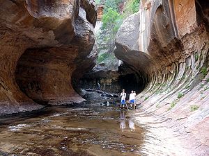
- Zion National ParkZion National ParkZion National Park is located in the Southwestern United States, near Springdale, Utah. A prominent feature of the park is Zion Canyon, which is 15 miles long and up to half a mile deep, cut through the reddish and tan-colored Navajo Sandstone by the North Fork of the Virgin River...
- Angel's Landing
- Checkerboard Mesa
- The Great White ThroneGreat White Throne (mountain)The Great White Throne is a mountain of white Navajo Sandstone situated in Zion National Park of southwestern Utah. The north face rises in from the floor of Zion Canyon near Angels Landing. It is often used as a symbol of Zion National Park...
- Kolob ArchKolob ArchKolob Arch is a natural arch in Zion National Park, Utah.The Natural Arch and Bridge Society considers Kolob Arch to be the second longest natural arch in the world. In 2006, the Society measured the span at 287.4 ± 2 feet , which is slightly shorter than the Landscape Arch in Arches National Park...
- The SubwaySubway (canyoneering)The Subway is a colloquial name for a uniquely-shaped slot canyon in Zion National Park. It is located between two peaks called the North and South Guardian Angels, deep within the Left Fork of North Creek. It is part of the larger Great West Canyon system, which includes both the Left and Right...
- The Three Patriarchs
- Zion Narrows
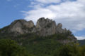
West VirginiaWest VirginiaWest Virginia is a state in the Appalachian and Southeastern regions of the United States, bordered by Virginia to the southeast, Kentucky to the southwest, Ohio to the northwest, Pennsylvania to the northeast and Maryland to the east...
- Seneca RocksSeneca RocksSeneca Rocks is a large crag and local landmark in Pendleton County in the Eastern Panhandle of West Virginia, USA. It is easily visible and accessible along West Virginia Route 28 near U.S. Route 33 in the Spruce Knob-Seneca Rocks National Recreation Area of the Monongahela National Forest...
, Pendleton CountyPendleton County, West VirginiaAs of the census of 2000, there were 8,196 people, 3,350 households, and 2,355 families residing in the county. The population density was 12 people per square mile . There were 5,102 housing units at an average density of 7 per square mile...
WisconsinWisconsinWisconsin is a U.S. state located in the north-central United States and is part of the Midwest. It is bordered by Minnesota to the west, Iowa to the southwest, Illinois to the south, Lake Michigan to the east, Michigan to the northeast, and Lake Superior to the north. Wisconsin's capital is...
- Dells of the Wisconsin RiverDells of the Wisconsin Riverthumb|250px|Dells of the Wisconsin RiverThe Dells of the Wisconsin River — also called the Wisconsin Dells — is a 5-mile gorge on the Wisconsin River in southern Wisconsin, USA...
- Maiden Rock
- Mill Bluff State ParkMill Bluff State ParkMill Bluff State Park is a state park of Wisconsin, USA, preserving several prominent sandstone bluffs. The park is located in eastern Monroe and western Juneau counties, near the village of Camp Douglas, and is a unit of the Ice Age National Scientific Reserve. The park protects several...
- Natural Bridge State ParkNatural Bridge State Park (Wisconsin)Natural Bridge State Park is an Wisconsin state park featuring the largest natural arch in the state. Directly beneath the arch is a rock shelter once used by Paleo-Indians...
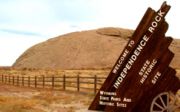
WyomingWyomingWyoming is a state in the mountain region of the Western United States. The western two thirds of the state is covered mostly with the mountain ranges and rangelands in the foothills of the Eastern Rocky Mountains, while the eastern third of the state is high elevation prairie known as the High...
- Independence RockIndependence Rock (Wyoming)Independence Rock is a large granite rock, approximately high, in southwestern Natrona County in the U.S. state of Wyoming, along Wyoming Highway 220. During the middle of the 19th century, the rock was a prominent and well-known landmark on the Oregon, Mormon and California emigrant trails. It...
- Teapot RockTeapot RockTeapot Rock is a distinctive rock formation in Natrona County, Wyoming that lent its name to a nearby oil field that became notorious as the focus of a bribery scandal during the Presidential administration of Warren G. Harding, the Teapot Dome scandal...
- VedauwooVedauwooVedauwoo is an area of rocky outcrops located in south-eastern Wyoming, United States, north of Interstate 80, between Laramie and Cheyenne. Its name is an anglicized version of the Arapaho word "bito'o'wu" meaning "earth-born"...
- Devils TowerDevils Tower National MonumentDevils Tower is an igneous intrusion or laccolith located in the Black Hills near Hulett and Sundance in Crook County, northeastern Wyoming, above the Belle Fourche River...