
Chief Mountain
Encyclopedia
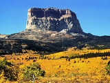
Chief Mountain is located in the U.S. state
of Montana
on the eastern border of Glacier National Park and the Blackfeet Indian Reservation
. The mountain is one of the most prominent peaks and rock formation
s along the Rocky Mountain Front
, a 200 mi (321.9 km) long overthrust fault, known as the Lewis Overthrust
, which extends from central Montana into southern Alberta
, Canada
.
which are immediately east of the mountain. Despite the mountain's being mostly in Montana, the distinctive eastern face quickly becomes hidden as one travels south into Montana, but remains very easy to see on clear days over much of southern Alberta
. Hence, many businesses in the area (notably Lethbridge
) have "Chief Mountain" in their name.
Chief Mountain is an example of a klippe
. It consists of a Precambrian block which rests directly above younger Cretaceous gray shales. The surrounding portion of the thrust sheet has been removed by erosion leaving behind this isolated block of Proterozoic rock.
tribes for hundreds of years. The Blackfoot name for the mountain is Ninastiko. The mountain was seen by white explorers in the late 18th century and was known as "Kings Peak" on maps produced in the United Kingdom
in 1795. Meriwether Lewis
, coleader of the Lewis and Clark Expedition
, saw the mountain in 1805 and called it "Tower Mountain". The name was changed in the late 19th century in reflection of Blackfeet
naming of the mountain which was "Great Chief". When Glacier National Park was created in 1910, the summit and most prominent eastern slopes of the mountain were located within the park, leaving only the lower slopes within Blackfeet jurisdiction
and provides poor anchor points, which in turn is a contributing factor to the difficulty rating. Henry Stimson and two other explorers, including a Blackfeet Indian, climbed the difficult eastern face on September 8, 1892, and this is the first known ascent of the peak by white explorers. Upon the summit, Stimson's party observed ceremonial remains including bison
skulls that had been left behind by Native Americans. The eastern face of the peak wasn't successfully climbed again until 1951. Though the summit can be gained by approaching from the west, the easiest access is from the east, and the Blackfeet tribe issues camping and access permits to cross reservation lands. National Park Service
visitor centers at St. Mary, Montana
and at Many Glacier
have additional information available.
U.S. state
A U.S. state is any one of the 50 federated states of the United States of America that share sovereignty with the federal government. Because of this shared sovereignty, an American is a citizen both of the federal entity and of his or her state of domicile. Four states use the official title of...
of Montana
Montana
Montana is a state in the Western United States. The western third of Montana contains numerous mountain ranges. Smaller, "island ranges" are found in the central third of the state, for a total of 77 named ranges of the Rocky Mountains. This geographical fact is reflected in the state's name,...
on the eastern border of Glacier National Park and the Blackfeet Indian Reservation
Blackfeet Indian Reservation
The Blackfeet Indian Reservation or Blackfeet Nation is an Indian reservation of the Blackfeet tribe in Montana in the United States. It is located east of Glacier National Park and borders Canada to the north. Cut Bank Creek and Birch Creek make up part of its eastern and southern borders...
. The mountain is one of the most prominent peaks and rock formation
Rock formations in the United States
The following is a partial list of rock formations in the United States, by state:-Arizona:*Canyon de Chelly National Monument**Spider Rock*Chiricahua National Monument**Duck on a Rock**Organ Pipe**Mushroom Rock**Sea Captain*Monument Valley...
s along the Rocky Mountain Front
Rocky Mountain Front
The Rocky Mountain Front is an area extending over 100 miles from the central regions of the U.S. state of Montana to southern Alberta, Canada. Here, the Rocky Mountains meet the Great Plains and Canadian Prairie in an abrupt elevation rise of between 4,000 to 5,000 feet...
, a 200 mi (321.9 km) long overthrust fault, known as the Lewis Overthrust
Lewis Overthrust
The Lewis Overthrust is a geologic fault structure of the Rocky Mountains within Glacier National Park in Montana, USA and Waterton Lakes National Park in Alberta, Canada, as well as into Lewis and Clark National Forest. It provides scientific insight into geologic processes happening in other...
, which extends from central Montana into southern Alberta
Alberta
Alberta is a province of Canada. It had an estimated population of 3.7 million in 2010 making it the most populous of Canada's three prairie provinces...
, Canada
Canada
Canada is a North American country consisting of ten provinces and three territories. Located in the northern part of the continent, it extends from the Atlantic Ocean in the east to the Pacific Ocean in the west, and northward into the Arctic Ocean...
.
The peak
The peak is easily seen from Montana and Alberta due to the rapid 5,000 foot (1,524 m) altitude gain over the Great PlainsGreat Plains
The Great Plains are a broad expanse of flat land, much of it covered in prairie, steppe and grassland, which lies west of the Mississippi River and east of the Rocky Mountains in the United States and Canada. This area covers parts of the U.S...
which are immediately east of the mountain. Despite the mountain's being mostly in Montana, the distinctive eastern face quickly becomes hidden as one travels south into Montana, but remains very easy to see on clear days over much of southern Alberta
Alberta
Alberta is a province of Canada. It had an estimated population of 3.7 million in 2010 making it the most populous of Canada's three prairie provinces...
. Hence, many businesses in the area (notably Lethbridge
Lethbridge
Lethbridge is a city in the province of Alberta, Canada, and the largest city in southern Alberta. It is Alberta's fourth-largest city by population after Calgary, Edmonton and Red Deer, and the third-largest by area after Calgary and Edmonton. The nearby Canadian Rockies contribute to the city's...
) have "Chief Mountain" in their name.
Chief Mountain is an example of a klippe
Klippe
thumb|right|350px|Schematic overview of a thrust system. The shaded material is called a [[nappe]]. The erosional hole is called a [[window |window or fenster]]. The klippe is the isolated block of the nappe overlying autochthonous material....
. It consists of a Precambrian block which rests directly above younger Cretaceous gray shales. The surrounding portion of the thrust sheet has been removed by erosion leaving behind this isolated block of Proterozoic rock.
Many names for a sacred place
Chief Mountain has been a sacred mountain to Native AmericanNative Americans in the United States
Native Americans in the United States are the indigenous peoples in North America within the boundaries of the present-day continental United States, parts of Alaska, and the island state of Hawaii. They are composed of numerous, distinct tribes, states, and ethnic groups, many of which survive as...
tribes for hundreds of years. The Blackfoot name for the mountain is Ninastiko. The mountain was seen by white explorers in the late 18th century and was known as "Kings Peak" on maps produced in the United Kingdom
United Kingdom
The United Kingdom of Great Britain and Northern IrelandIn the United Kingdom and Dependencies, other languages have been officially recognised as legitimate autochthonous languages under the European Charter for Regional or Minority Languages...
in 1795. Meriwether Lewis
Meriwether Lewis
Meriwether Lewis was an American explorer, soldier, and public administrator, best known for his role as the leader of the Lewis and Clark Expedition also known as the Corps of Discovery, with William Clark...
, coleader of the Lewis and Clark Expedition
Lewis and Clark Expedition
The Lewis and Clark Expedition, or ″Corps of Discovery Expedition" was the first transcontinental expedition to the Pacific Coast by the United States. Commissioned by President Thomas Jefferson and led by two Virginia-born veterans of Indian wars in the Ohio Valley, Meriwether Lewis and William...
, saw the mountain in 1805 and called it "Tower Mountain". The name was changed in the late 19th century in reflection of Blackfeet
Blackfeet
The Piegan Blackfeet are a tribe of Native Americans of the Algonquian language family based in Montana, having lived in this area since around 6,500 BC. Many members of the tribe live as part of the Blackfeet Nation in northwestern Montana, with population centered in Browning...
naming of the mountain which was "Great Chief". When Glacier National Park was created in 1910, the summit and most prominent eastern slopes of the mountain were located within the park, leaving only the lower slopes within Blackfeet jurisdiction
Climbing
The eastern face of the mountain rises over 1,500 vertical feet (457 m) and the easiest route on this section is rated class 4 by mountaineers. The rock is also primarily sedimentarySedimentary rock
Sedimentary rock are types of rock that are formed by the deposition of material at the Earth's surface and within bodies of water. Sedimentation is the collective name for processes that cause mineral and/or organic particles to settle and accumulate or minerals to precipitate from a solution....
and provides poor anchor points, which in turn is a contributing factor to the difficulty rating. Henry Stimson and two other explorers, including a Blackfeet Indian, climbed the difficult eastern face on September 8, 1892, and this is the first known ascent of the peak by white explorers. Upon the summit, Stimson's party observed ceremonial remains including bison
Bison
Members of the genus Bison are large, even-toed ungulates within the subfamily Bovinae. Two extant and four extinct species are recognized...
skulls that had been left behind by Native Americans. The eastern face of the peak wasn't successfully climbed again until 1951. Though the summit can be gained by approaching from the west, the easiest access is from the east, and the Blackfeet tribe issues camping and access permits to cross reservation lands. National Park Service
National Park Service
The National Park Service is the U.S. federal agency that manages all national parks, many national monuments, and other conservation and historical properties with various title designations...
visitor centers at St. Mary, Montana
St. Mary, Montana
St. Mary is an unincorporated community on the western border of the Blackfeet Indian Reservation adjacent to Glacier National Park in Glacier County, Montana, United States. The village is the eastern terminus of the Going-to-the-Sun Road which bisects the park east to west, a distance of ...
and at Many Glacier
Many Glacier
Many Glacier is an area within Glacier National Park which is located in the U.S. state of Montana. The Many Glacier region is located north of the Going-to-the-Sun Road, on the east side of the park. Lake Sherburne is the large lake in the area and the Many Glacier Hotel, the largest hotel within...
have additional information available.
See also
- Rocky MountainsRocky MountainsThe Rocky Mountains are a major mountain range in western North America. The Rocky Mountains stretch more than from the northernmost part of British Columbia, in western Canada, to New Mexico, in the southwestern United States...
- Ninaki MountainNinaki MountainNinaki Mountain is located in Montana, SW of Chief Mountain. It was named in honour of the sacrifice of the wife who threw her baby, then herself off the mountain in reaction to the death of her war-chief husband as a result of a battle which took place between Peigan and Blackfeet...
- Mountains and mountain ranges of Glacier National Park (U.S.)Mountains and mountain ranges of Glacier National Park (U.S.)Mountains in Glacier National Park are part of the Rocky Mountains. There are at least 150 named mountain peaks over in Glacier in three mountain ranges--the Clark Range, Lewis Range, Livingston Range. Mount Cleveland el....