
Pompeys Pillar National Monument
Encyclopedia
Rock formations in the United States
The following is a partial list of rock formations in the United States, by state:-Arizona:*Canyon de Chelly National Monument**Spider Rock*Chiricahua National Monument**Duck on a Rock**Organ Pipe**Mushroom Rock**Sea Captain*Monument Valley...
located in south central Montana
Montana
Montana is a state in the Western United States. The western third of Montana contains numerous mountain ranges. Smaller, "island ranges" are found in the central third of the state, for a total of 77 named ranges of the Rocky Mountains. This geographical fact is reflected in the state's name,...
, United States
United States
The United States of America is a federal constitutional republic comprising fifty states and a federal district...
. Designated a National Monument
U.S. National Monument
A National Monument in the United States is a protected area that is similar to a National Park except that the President of the United States can quickly declare an area of the United States to be a National Monument without the approval of Congress. National monuments receive less funding and...
on January 17, 2001, and managed by the U.S. Bureau of Land Management
Bureau of Land Management
The Bureau of Land Management is an agency within the United States Department of the Interior which administers America's public lands, totaling approximately , or one-eighth of the landmass of the country. The BLM also manages of subsurface mineral estate underlying federal, state and private...
, it consists of only 51 acres (20.6 ha), making it one of the smallest National Monuments in the U.S. It was previously designated a National Historic Landmark
National Historic Landmark
A National Historic Landmark is a building, site, structure, object, or district, that is officially recognized by the United States government for its historical significance...
on July 25, 1965.
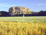
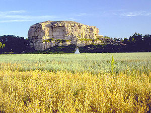
The pillar itself stands 150 feet (45 m) above the Yellowstone River
Yellowstone River
The Yellowstone River is a tributary of the Missouri River, approximately long, in the western United States. Considered the principal tributary of the upper Missouri, the river and its tributaries drain a wide area stretching from the Rocky Mountains in the vicinity of the Yellowstone National...
and consists of sandstone
Sandstone
Sandstone is a sedimentary rock composed mainly of sand-sized minerals or rock grains.Most sandstone is composed of quartz and/or feldspar because these are the most common minerals in the Earth's crust. Like sand, sandstone may be any colour, but the most common colours are tan, brown, yellow,...
from the late Cretaceous
Cretaceous
The Cretaceous , derived from the Latin "creta" , usually abbreviated K for its German translation Kreide , is a geologic period and system from circa to million years ago. In the geologic timescale, the Cretaceous follows the Jurassic period and is followed by the Paleogene period of the...
Hell Creek Formation
Hell Creek Formation
The Hell Creek Formation is an intensely-studied division of Upper Cretaceous to lower Paleocene rocks in North America, named for exposures studied along Hell Creek, near Jordan, Montana...
, 75–65 million years ago. The base of the pillar is approximately 1 acre (0.404686 ha).
The pillar features an abundance of Native American
Native Americans in the United States
Native Americans in the United States are the indigenous peoples in North America within the boundaries of the present-day continental United States, parts of Alaska, and the island state of Hawaii. They are composed of numerous, distinct tribes, states, and ethnic groups, many of which survive as...
petroglyph
Petroglyph
Petroglyphs are pictogram and logogram images created by removing part of a rock surface by incising, picking, carving, and abrading. Outside North America, scholars often use terms such as "carving", "engraving", or other descriptions of the technique to refer to such images...
s, as well as the signature of William Clark, co-leader of the Lewis and Clark Expedition
Lewis and Clark Expedition
The Lewis and Clark Expedition, or ″Corps of Discovery Expedition" was the first transcontinental expedition to the Pacific Coast by the United States. Commissioned by President Thomas Jefferson and led by two Virginia-born veterans of Indian wars in the Ohio Valley, Meriwether Lewis and William...
. Clark's inscription is the only remaining physical evidence found along the route that was followed by the expedition.
The inscription consists of his signature and the date, July 25, 1806. Clark wrote that he climbed the sandstone pillar and "had a most extensive view in every direction on the Northerly Side of the river". He named the outcropping after Jean Baptiste Charbonneau
Jean Baptiste Charbonneau
Jean Baptiste Charbonneau was an American explorer and guide, fur trapper and trader, military scout during the Mexican-American War, alcalde of Mission San Luis Rey de Francia, and a gold prospector and hotel operator in California. He spoke French and English, and learned German and Spanish...
—the son of expedition member Sacagawea
Sacagawea
Sacagawea ; was a Lemhi Shoshone woman, who accompanied the Lewis and Clark Expedition, acting as an interpreter and guide, in their exploration of the Western United States...
—whom he nicknamed "Pompy". His original name for it was "Pompys Tower"; it was changed to the current title in 1814.
Situated 25 miles (40 km) northeast of Billings, Montana
Billings, Montana
Billings is the largest city in the U.S. state of Montana, and is the principal city of the Billings Metropolitan Area, the largest metropolitan area in over...
, along Interstate 94
Interstate 94
Interstate 94 is the northernmost east–west Interstate Highway, connecting the Great Lakes and Intermountain regions of the United States. I-94's western terminus is in Billings, Montana at a junction with Interstate 90; its eastern terminus is the U.S...
, the pillar gets 50,000 visitors annually. Archeological evidence suggests that the outcropping has been witness to 11,000 years of human involvement in the area. Consequently, in addition to the pictographs and the signature of William Clark, hundreds of other people have carved their initials into the rock, including early pioneers to the area.