
Malheur County, Oregon
Encyclopedia
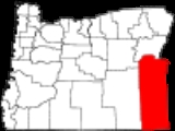
Malheur County is a county located in the southeast corner of the U.S. state
of Oregon
. It is included in the eight-county definition of Eastern Oregon
. Most of the county observes the Mountain Time Zone
, although the southern quarter of the county observes the Pacific Time Zone
along with the rest of the state. The county was named
for Malheur River
, which flows through it. , the population was 31,313. Ontario
is the largest city and the county seat
is Vale
. The word "malheur" means misfortune in French.
Malheur County is part of the Ontario, OR–ID
Micropolitan Statistical Area
.
. It was first settled by miners and stockmen in the early 1860s. The discovery of gold in 1863 attracted further development, including settlements and ranches. Basques
settled in the region in the 1890s and were mainly engaged in sheep raising.
, the county has a total area of 9930 square miles (25,718.6 km²), of which 9887 square miles (25,607.2 km²) is land and 43 square miles (111.4 km²) (0.43%) is water.
of 2000, there were 31,615 people, 10,221 households, and 7,348 families residing in the county. The population density
was 3 people per square mile (1/km²). There were 11,233 housing units at an average density of 1 per square mile (0/km²). The racial makeup of the county was:
25.62% of the population were Hispanic
or Latino
of any race. 14.2% were of German, 10.5% English
, 8.4% American
and 6.9% Irish
ancestry according to Census 2000. 79.4% spoke English
and 19.4% Spanish
as their first language.
There were 10,221 households out of which 36.20% had children under the age of 18 living with them, 57.30% were married couples
living together, 10.40% had a female householder with no husband present, and 28.10% were non-families. 23.70% of all households were made up of individuals and 12.00% had someone living alone who was 65 years of age or older. The average household size was 2.77 and the average family size was 3.28.
In the county, the population was spread out with 27.60% under the age of 18, 10.60% from 18 to 24, 27.20% from 25 to 44, 21.00% from 45 to 64, and 13.70% who were 65 years of age or older. The median age was 34 years. For every 100 females there were 116.00 males. For every 100 females age 18 and over, there were 121.20 males.
The median income for a household in the county was $30,241, and the median income for a family was $35,672. Males had a median income of $25,489 versus $21,764 for females. The per capita income
for the county was $13,895. About 14.60% of families and 18.60% of the population were below the poverty line, including 25.80% of those under age 18 and 11.60% of those age 65 or over.
(BLM) controlling 72% of the land. Irrigated
fields in the county's northeast corner, known as Western Treasure Valley
, are the center of intensive and diversified farming. Malheur County's economy also depends on tourism.
Because of its economic relationship with Idaho
, most of Malheur county is in the Mountain time zone
, making it the only county in Oregon that does not completely follow Pacific Time. The largely unpopulated southern quarter of the county, near McDermitt
, observes Pacific Time. The legal dividing line between the two goes through the southwest corner of township 35 S, range 37 E, and lies at a latitude of approximately 42.4507448 N. Malheur is one of the few counties in the U.S. that legally observes two different time zones.
The county's two largest employers are the Snake River Correctional Institution
and Ore-Ida
, a potato processor owned by H.J. Heinz.
Malheur County is the poorest county in Oregon. As of 2008, 21% of its residents live in poverty.
in Malheur County are members of the Republican Party
. In the 2008 presidential election
, 69.10% of Malheur County voters voted for Republican John McCain
, while 28.47% voted for Democrat
Barack Obama
and 2.42% of voters voted for a third-party
candidate. These statistics do not include write-in votes
. These numbers show a small shift towards the Democratic candidate when compared to the 2004 presidential election
, in which 74.9% of Malheur Country voters voted for George W. Bush
, while 23.8% voted for John Kerry
, and 1.3% of voters either voted for a third-party candidate or wrote in a candidate
.

Malheur County is one of the most Republican counties in Oregon when it comes to Presidential elections. It was one of only two counties in Oregon to give the majority of its vote to Barry Goldwater
and has favored the Republican candidate for decades. The last Democratic candidate to carry the county was Franklin D. Roosevelt
in 1940. Further every Republican candidate since 1996 has received more than 60% of the county's vote.
As part of Oregon's 2nd congressional district
it has been represented by Republicans for over 27 years with Greg Walden
being the current representative.
U.S. state
A U.S. state is any one of the 50 federated states of the United States of America that share sovereignty with the federal government. Because of this shared sovereignty, an American is a citizen both of the federal entity and of his or her state of domicile. Four states use the official title of...
of Oregon
Oregon
Oregon is a state in the Pacific Northwest region of the United States. It is located on the Pacific coast, with Washington to the north, California to the south, Nevada on the southeast and Idaho to the east. The Columbia and Snake rivers delineate much of Oregon's northern and eastern...
. It is included in the eight-county definition of Eastern Oregon
Eastern Oregon
Eastern Oregon is the eastern part of the U.S. state of Oregon. It is not an officially recognized geographic entity, thus the boundaries of the region vary according to context. It is sometimes understood to include only the eight easternmost counties in the state; in other contexts, it includes...
. Most of the county observes the Mountain Time Zone
Mountain Time Zone
The Mountain Time Zone of North America keeps time by subtracting seven hours from Coordinated Universal Time, also known as Greenwich Mean Time, during the shortest days of autumn and winter , and by subtracting six hours during daylight saving time in the spring, summer, and early autumn...
, although the southern quarter of the county observes the Pacific Time Zone
Pacific Time Zone
The Pacific Time Zone observes standard time by subtracting eight hours from Coordinated Universal Time . The clock time in this zone is based on the mean solar time of the 120th meridian west of the Greenwich Observatory. During daylight saving time, its time offset is UTC-7.In the United States...
along with the rest of the state. The county was named
Oregon Geographic Names
Oregon Geographic Names is an authoritative compilation of the origin and meaning of place names in the U.S. state of Oregon. , the book is in its seventh edition and is compiled and edited by Lewis L. McArthur, who took over from his father, Lewis A. McArthur, as of the fourth edition...
for Malheur River
Malheur River
The Malheur River is a tributary of the Snake River in eastern Oregon in the United States. It drains a high desert area, between the Harney Basin and the Blue Mountains and the Snake....
, which flows through it. , the population was 31,313. Ontario
Ontario, Oregon
Ontario is the largest city in Malheur County, Oregon, United States. It lies along the Snake River at the Idaho border. The population was 10,985 at the 2000 census, with an estimated population of 11,245 in 2006...
is the largest city and the county seat
County seat
A county seat is an administrative center, or seat of government, for a county or civil parish. The term is primarily used in the United States....
is Vale
Vale, Oregon
Vale is a city in Malheur County, Oregon, United States, about west of the Idaho border. It is at the intersection of U.S. Routes 20 and 26, on the Malheur River.Vale was selected as Malheur's county seat in 1955, 68 years after the county was founded...
. The word "malheur" means misfortune in French.
Malheur County is part of the Ontario, OR–ID
Idaho
Idaho is a state in the Rocky Mountain area of the United States. The state's largest city and capital is Boise. Residents are called "Idahoans". Idaho was admitted to the Union on July 3, 1890, as the 43rd state....
Micropolitan Statistical Area
Ontario micropolitan area
The Ontario Micropolitan Statistical Area, as defined by the United States Census Bureau, is an area consisting of two counties – one in southeastern Oregon and one in southwestern Idaho, anchored by the city of Ontario....
.
History
Malheur County was created February 17, 1887, from the southern portion of Baker CountyBaker County, Oregon
Baker County is a county located in the U.S. state of Oregon. It is included in the 8 county definition of Eastern Oregon. It is named for Edward Dickinson Baker, a senator from Oregon who was killed at Ball's Bluff, a battle of the Civil War in Virginia in 1861. It was split from the eastern part...
. It was first settled by miners and stockmen in the early 1860s. The discovery of gold in 1863 attracted further development, including settlements and ranches. Basques
Basque people
The Basques as an ethnic group, primarily inhabit an area traditionally known as the Basque Country , a region that is located around the western end of the Pyrenees on the coast of the Bay of Biscay and straddles parts of north-central Spain and south-western France.The Basques are known in the...
settled in the region in the 1890s and were mainly engaged in sheep raising.
Geography
According to the U.S. Census BureauUnited States Census Bureau
The United States Census Bureau is the government agency that is responsible for the United States Census. It also gathers other national demographic and economic data...
, the county has a total area of 9930 square miles (25,718.6 km²), of which 9887 square miles (25,607.2 km²) is land and 43 square miles (111.4 km²) (0.43%) is water.
Adjacent counties
- Harney CountyHarney County, Oregon-National protected areas:*Malheur National Forest *Malheur National Wildlife Refuge*Ochoco National Forest -Demographics:As of the census of 2000, there were 7,609 people, 3,036 households, and 2,094 families residing in the county. The population density was 1 people per square mile...
- (west) - Grant CountyGrant County, OregonGrant County is a county located in the U.S. state of Oregon. It is included in the 8 county definition of Eastern Oregon. In 2010, its population was 7,445. It is named for President Ulysses S. Grant, who served as an army officer in the Oregon Territory, and at the time of the county's creation...
- (northwest) - Baker CountyBaker County, OregonBaker County is a county located in the U.S. state of Oregon. It is included in the 8 county definition of Eastern Oregon. It is named for Edward Dickinson Baker, a senator from Oregon who was killed at Ball's Bluff, a battle of the Civil War in Virginia in 1861. It was split from the eastern part...
- (north) - Washington CountyWashington County, IdahoWashington County is a county in the U.S. state of Idaho. Established in 1879 when Idaho was a territory, it was named after U.S. president George Washington. As of the 2000 Census, the county had a population of 9,977; it is estimated to have risen to 10,147 by 2007...
, IdahoIdahoIdaho is a state in the Rocky Mountain area of the United States. The state's largest city and capital is Boise. Residents are called "Idahoans". Idaho was admitted to the Union on July 3, 1890, as the 43rd state....
- (northeast) - Payette CountyPayette County, IdahoPayette County is a county located in the U.S. state of Idaho. The county was established in 1917, and at the 2000 Census the county had a population of 20,578 . The county seat is Payette....
, IdahoIdahoIdaho is a state in the Rocky Mountain area of the United States. The state's largest city and capital is Boise. Residents are called "Idahoans". Idaho was admitted to the Union on July 3, 1890, as the 43rd state....
- (east) - Canyon CountyCanyon County, IdahoCanyon County is a county located in the U.S. state of Idaho. As of the 2010 Census the county had a population of 188,923. The county seat is Caldwell, and its largest city is Nampa.. Canyon County is part of the Boise City–Nampa, Idaho Metropolitan Statistical Area.- History :The county was...
, IdahoIdahoIdaho is a state in the Rocky Mountain area of the United States. The state's largest city and capital is Boise. Residents are called "Idahoans". Idaho was admitted to the Union on July 3, 1890, as the 43rd state....
- (east) - Owyhee CountyOwyhee County, IdahoOwyhee County is a county located in the southwestern corner of the U.S. state of Idaho. In area it is the second largest county in Idaho, behind Idaho County. As of the 2000 Census, Owyhee County had a population of 10,644...
, IdahoIdahoIdaho is a state in the Rocky Mountain area of the United States. The state's largest city and capital is Boise. Residents are called "Idahoans". Idaho was admitted to the Union on July 3, 1890, as the 43rd state....
- (east) - Humboldt CountyHumboldt County, NevadaHumboldt County is a county located in the U.S. state of Nevada. As of 2007, the population was estimated to be 18,052. Its county seat is Winnemucca.The county was the site of an arrest in 2000 that led to the U.S. Supreme Court decision Hiibel v...
, NevadaNevadaNevada is a state in the western, mountain west, and southwestern regions of the United States. With an area of and a population of about 2.7 million, it is the 7th-largest and 35th-most populous state. Over two-thirds of Nevada's people live in the Las Vegas metropolitan area, which contains its...
- (south)
National protected areas
- Deer Flat National Wildlife RefugeDeer Flat National Wildlife RefugeThe Deer Flat National Wildlife Refuge is an important breeding area for mammals, birds, and other animals. The National Wildlife Refuge is located on land surrounding Lake Lowell, just outside Nampa, Idaho...
(part) - Malheur National ForestMalheur National ForestThe Malheur National Forest is a National Forest in the U.S. state of Oregon. It contains 1.7 million acres in the Blue Mountains of eastern Oregon. The forest include high desert grasslands, sage, juniper, pine, fir, and other tree species. Elevations vary from about 4000 feet to the 9038...
(part) - Whitman National ForestWhitman National ForestWhitman National Forest was established in Oregon on July 1, 1908 with from part of Blue Mountains National Forest. On June 20, 1920 part of Minam National Forest was added. In 1954 it was administratively combined with Wallowa National Forest to make Wallowa–Whitman National Forest...
(part)
Highways
|
 -
-  -
-  -
-  - US 30
 - US 95
 -
-  - OR 201
Demographics
As of the censusCensus
A census is the procedure of systematically acquiring and recording information about the members of a given population. It is a regularly occurring and official count of a particular population. The term is used mostly in connection with national population and housing censuses; other common...
of 2000, there were 31,615 people, 10,221 households, and 7,348 families residing in the county. The population density
Population density
Population density is a measurement of population per unit area or unit volume. It is frequently applied to living organisms, and particularly to humans...
was 3 people per square mile (1/km²). There were 11,233 housing units at an average density of 1 per square mile (0/km²). The racial makeup of the county was:
- 75.78% WhiteRace (United States Census)Race and ethnicity in the United States Census, as defined by the Federal Office of Management and Budget and the United States Census Bureau, are self-identification data items in which residents choose the race or races with which they most closely identify, and indicate whether or not they are...
- 1.22% BlackRace (United States Census)Race and ethnicity in the United States Census, as defined by the Federal Office of Management and Budget and the United States Census Bureau, are self-identification data items in which residents choose the race or races with which they most closely identify, and indicate whether or not they are...
or African AmericanRace (United States Census)Race and ethnicity in the United States Census, as defined by the Federal Office of Management and Budget and the United States Census Bureau, are self-identification data items in which residents choose the race or races with which they most closely identify, and indicate whether or not they are... - 1.02% Native AmericanRace (United States Census)Race and ethnicity in the United States Census, as defined by the Federal Office of Management and Budget and the United States Census Bureau, are self-identification data items in which residents choose the race or races with which they most closely identify, and indicate whether or not they are...
- 1.96% AsianRace (United States Census)Race and ethnicity in the United States Census, as defined by the Federal Office of Management and Budget and the United States Census Bureau, are self-identification data items in which residents choose the race or races with which they most closely identify, and indicate whether or not they are...
- 0.08% Pacific IslanderRace (United States Census)Race and ethnicity in the United States Census, as defined by the Federal Office of Management and Budget and the United States Census Bureau, are self-identification data items in which residents choose the race or races with which they most closely identify, and indicate whether or not they are...
- 17.38% from other racesRace (United States Census)Race and ethnicity in the United States Census, as defined by the Federal Office of Management and Budget and the United States Census Bureau, are self-identification data items in which residents choose the race or races with which they most closely identify, and indicate whether or not they are...
- 2.56% from two or more races
25.62% of the population were Hispanic
Race (United States Census)
Race and ethnicity in the United States Census, as defined by the Federal Office of Management and Budget and the United States Census Bureau, are self-identification data items in which residents choose the race or races with which they most closely identify, and indicate whether or not they are...
or Latino
Race (United States Census)
Race and ethnicity in the United States Census, as defined by the Federal Office of Management and Budget and the United States Census Bureau, are self-identification data items in which residents choose the race or races with which they most closely identify, and indicate whether or not they are...
of any race. 14.2% were of German, 10.5% English
English people
The English are a nation and ethnic group native to England, who speak English. The English identity is of early mediaeval origin, when they were known in Old English as the Anglecynn. England is now a country of the United Kingdom, and the majority of English people in England are British Citizens...
, 8.4% American
United States
The United States of America is a federal constitutional republic comprising fifty states and a federal district...
and 6.9% Irish
Irish people
The Irish people are an ethnic group who originate in Ireland, an island in northwestern Europe. Ireland has been populated for around 9,000 years , with the Irish people's earliest ancestors recorded having legends of being descended from groups such as the Nemedians, Fomorians, Fir Bolg, Tuatha...
ancestry according to Census 2000. 79.4% spoke English
English language
English is a West Germanic language that arose in the Anglo-Saxon kingdoms of England and spread into what was to become south-east Scotland under the influence of the Anglian medieval kingdom of Northumbria...
and 19.4% Spanish
Spanish language
Spanish , also known as Castilian , is a Romance language in the Ibero-Romance group that evolved from several languages and dialects in central-northern Iberia around the 9th century and gradually spread with the expansion of the Kingdom of Castile into central and southern Iberia during the...
as their first language.
There were 10,221 households out of which 36.20% had children under the age of 18 living with them, 57.30% were married couples
Marriage
Marriage is a social union or legal contract between people that creates kinship. It is an institution in which interpersonal relationships, usually intimate and sexual, are acknowledged in a variety of ways, depending on the culture or subculture in which it is found...
living together, 10.40% had a female householder with no husband present, and 28.10% were non-families. 23.70% of all households were made up of individuals and 12.00% had someone living alone who was 65 years of age or older. The average household size was 2.77 and the average family size was 3.28.
In the county, the population was spread out with 27.60% under the age of 18, 10.60% from 18 to 24, 27.20% from 25 to 44, 21.00% from 45 to 64, and 13.70% who were 65 years of age or older. The median age was 34 years. For every 100 females there were 116.00 males. For every 100 females age 18 and over, there were 121.20 males.
The median income for a household in the county was $30,241, and the median income for a family was $35,672. Males had a median income of $25,489 versus $21,764 for females. The per capita income
Per capita income
Per capita income or income per person is a measure of mean income within an economic aggregate, such as a country or city. It is calculated by taking a measure of all sources of income in the aggregate and dividing it by the total population...
for the county was $13,895. About 14.60% of families and 18.60% of the population were below the poverty line, including 25.80% of those under age 18 and 11.60% of those age 65 or over.
Economy
The county is 94% rangeland, with the Bureau of Land ManagementBureau of Land Management
The Bureau of Land Management is an agency within the United States Department of the Interior which administers America's public lands, totaling approximately , or one-eighth of the landmass of the country. The BLM also manages of subsurface mineral estate underlying federal, state and private...
(BLM) controlling 72% of the land. Irrigated
Irrigation
Irrigation may be defined as the science of artificial application of water to the land or soil. It is used to assist in the growing of agricultural crops, maintenance of landscapes, and revegetation of disturbed soils in dry areas and during periods of inadequate rainfall...
fields in the county's northeast corner, known as Western Treasure Valley
Treasure Valley
The Treasure Valley is the area of the Western United States where the Payette, Boise, Weiser, Malheur, Owyhee, and Burnt rivers drain into the Snake River. Treasure Valley includes all the lowland areas from Vale, Oregon on the west to Boise, Idaho on the east. Formerly, the valley had been known...
, are the center of intensive and diversified farming. Malheur County's economy also depends on tourism.
Because of its economic relationship with Idaho
Idaho
Idaho is a state in the Rocky Mountain area of the United States. The state's largest city and capital is Boise. Residents are called "Idahoans". Idaho was admitted to the Union on July 3, 1890, as the 43rd state....
, most of Malheur county is in the Mountain time zone
Time zone
A time zone is a region on Earth that has a uniform standard time for legal, commercial, and social purposes. In order for the same clock time to always correspond to the same portion of the day as the Earth rotates , different places on the Earth need to have different clock times...
, making it the only county in Oregon that does not completely follow Pacific Time. The largely unpopulated southern quarter of the county, near McDermitt
McDermitt, Nevada-Oregon
McDermitt is an unincorporated community straddling the Nevada–Oregon border, in Humboldt County, Nevada, and Malheur County, Oregon in the United States. For statistical purposes, the census bureau has allocated McDermitt two census-designated places , McDermitt NV and Fort McDermitt NV...
, observes Pacific Time. The legal dividing line between the two goes through the southwest corner of township 35 S, range 37 E, and lies at a latitude of approximately 42.4507448 N. Malheur is one of the few counties in the U.S. that legally observes two different time zones.
The county's two largest employers are the Snake River Correctional Institution
Oregon Department of Corrections
The Oregon Department of Corrections is the agency of the U.S. state of Oregon charged with managing a system of 14 state prisons since its creation by the state legislature in 1987...
and Ore-Ida
Ore-Ida
Ore-Ida is a brand of potato-based frozen foods currently produced and distributed by the H. J. Heinz Company. Ore-Ida's primary production facility is located in Ontario, Oregon, and the company employs over 1,000 local residents...
, a potato processor owned by H.J. Heinz.
Malheur County is the poorest county in Oregon. As of 2008, 21% of its residents live in poverty.
Politics
Like all counties in eastern Oregon, the majority of registered voters who are part of a political partyPolitical party
A political party is a political organization that typically seeks to influence government policy, usually by nominating their own candidates and trying to seat them in political office. Parties participate in electoral campaigns, educational outreach or protest actions...
in Malheur County are members of the Republican Party
Republican Party (United States)
The Republican Party is one of the two major contemporary political parties in the United States, along with the Democratic Party. Founded by anti-slavery expansion activists in 1854, it is often called the GOP . The party's platform generally reflects American conservatism in the U.S...
. In the 2008 presidential election
United States presidential election, 2008
The United States presidential election of 2008 was the 56th quadrennial presidential election. It was held on November 4, 2008. Democrat Barack Obama, then the junior United States Senator from Illinois, defeated Republican John McCain, the senior U.S. Senator from Arizona. Obama received 365...
, 69.10% of Malheur County voters voted for Republican John McCain
John McCain
John Sidney McCain III is the senior United States Senator from Arizona. He was the Republican nominee for president in the 2008 United States election....
, while 28.47% voted for Democrat
Democratic Party (United States)
The Democratic Party is one of two major contemporary political parties in the United States, along with the Republican Party. The party's socially liberal and progressive platform is largely considered center-left in the U.S. political spectrum. The party has the lengthiest record of continuous...
Barack Obama
Barack Obama
Barack Hussein Obama II is the 44th and current President of the United States. He is the first African American to hold the office. Obama previously served as a United States Senator from Illinois, from January 2005 until he resigned following his victory in the 2008 presidential election.Born in...
and 2.42% of voters voted for a third-party
Third party (politics)
In a two-party system of politics, the term third party is sometimes applied to a party other than the two dominant ones. While technically the term is limited to the third largest party or third oldest party, it is common, though innumerate, shorthand for any smaller party.For instance, in the...
candidate. These statistics do not include write-in votes
Write-in candidate
A write-in candidate is a candidate in an election whose name does not appear on the ballot, but for whom voters may vote nonetheless by writing in the person's name. Some states and local jurisdictions allow a voter to affix a sticker with a write-in candidate's name on it to the ballot in lieu...
. These numbers show a small shift towards the Democratic candidate when compared to the 2004 presidential election
United States presidential election, 2004
The United States presidential election of 2004 was the United States' 55th quadrennial presidential election. It was held on Tuesday, November 2, 2004. Republican Party candidate and incumbent President George W. Bush defeated Democratic Party candidate John Kerry, the then-junior U.S. Senator...
, in which 74.9% of Malheur Country voters voted for George W. Bush
George W. Bush
George Walker Bush is an American politician who served as the 43rd President of the United States, from 2001 to 2009. Before that, he was the 46th Governor of Texas, having served from 1995 to 2000....
, while 23.8% voted for John Kerry
John Kerry
John Forbes Kerry is the senior United States Senator from Massachusetts, the 10th most senior U.S. Senator and chairman of the Senate Foreign Relations Committee. He was the presidential nominee of the Democratic Party in the 2004 presidential election, but lost to former President George W...
, and 1.3% of voters either voted for a third-party candidate or wrote in a candidate
Write-in candidate
A write-in candidate is a candidate in an election whose name does not appear on the ballot, but for whom voters may vote nonetheless by writing in the person's name. Some states and local jurisdictions allow a voter to affix a sticker with a write-in candidate's name on it to the ballot in lieu...
.
Malheur County is one of the most Republican counties in Oregon when it comes to Presidential elections. It was one of only two counties in Oregon to give the majority of its vote to Barry Goldwater
Barry Goldwater
Barry Morris Goldwater was a five-term United States Senator from Arizona and the Republican Party's nominee for President in the 1964 election. An articulate and charismatic figure during the first half of the 1960s, he was known as "Mr...
and has favored the Republican candidate for decades. The last Democratic candidate to carry the county was Franklin D. Roosevelt
Franklin D. Roosevelt
Franklin Delano Roosevelt , also known by his initials, FDR, was the 32nd President of the United States and a central figure in world events during the mid-20th century, leading the United States during a time of worldwide economic crisis and world war...
in 1940. Further every Republican candidate since 1996 has received more than 60% of the county's vote.
As part of Oregon's 2nd congressional district
Oregon's 2nd congressional district
Oregon's 2nd congressional district is the largest of Oregon's five districts, and is the seventh largest district in the nation. The district covers roughly two-thirds of the state, east of the Willamette Valley...
it has been represented by Republicans for over 27 years with Greg Walden
Greg Walden
Gregory Paul Walden is the U.S. Representative for , serving since 1999. He is a member of the Republican Party.The district covers more than two-thirds of the state . He is the son of Paul E...
being the current representative.
Communities
Incorporated cities
- AdrianAdrian, OregonAdrian is a city in Malheur County, Oregon, United States, near the confluence of the Snake River and the Owyhee River. The population was 147 at the 2000 census and a census estimated population of 140 in 2009. It is part of the Ontario, OR–ID Micropolitan Statistical Area.-History:In 1913,...
- Jordan ValleyJordan Valley, OregonJordan Valley is a city in Malheur County, Oregon, United States. It is part of the Ontario, OR–ID Micropolitan Statistical Area. The city was named after Jordan Creek, a tributary of Owyhee River, which runs through the city; the creek is named for a 19th century prospector, Michael M. Jordan...
- NyssaNyssa, OregonNyssa is a city in Malheur County, Oregon, United States. The population was 3,163 at the 2000 census. The city is located along the Snake River on the Idaho border, in the region of far eastern Oregon known as the "Treasure Valley"...
- OntarioOntario, OregonOntario is the largest city in Malheur County, Oregon, United States. It lies along the Snake River at the Idaho border. The population was 10,985 at the 2000 census, with an estimated population of 11,245 in 2006...
- ValeVale, OregonVale is a city in Malheur County, Oregon, United States, about west of the Idaho border. It is at the intersection of U.S. Routes 20 and 26, on the Malheur River.Vale was selected as Malheur's county seat in 1955, 68 years after the county was founded...
Unincorporated communities
- ArockArock, OregonArock is an unincorporated community in Malheur County, Oregon, United States. It is part of the Ontario, OR–ID Micropolitan Statistical Area. Arock is three miles north of U.S. Route 95 between Jordan Valley and Rome....
- BroganBrogan, OregonBrogan is an unincorporated community in Malheur County, Oregon, United States, on U.S. Route 26. Brogan was founded by D. M. Brogan in 1909, and when a post office was established in the locality on April 23 of that year, it was named for him...
- Burns Junction
- DannerDanner, OregonDanner is an unincorporated community located in Malheur County, Oregon, United States, near Jordan Valley.-History:The old Idaho-Oregon-Nevada highway ran through Danner, following the route of the Skinner Toll Road which opened the area for settlement in 1863.Danner is the location of the grave...
(a ghost townGhost townA ghost town is an abandoned town or city. A town often becomes a ghost town because the economic activity that supported it has failed, or due to natural or human-caused disasters such as floods, government actions, uncontrolled lawlessness, war, or nuclear disasters...
) - HarperHarper, OregonHarper is an unincorporated community in Malheur County, Oregon, United States. Although it is unincorporated, it has a post office with a ZIP code of 97906. Harper lies off U.S. Route 20 southwest of Vale.-Transportation:...
- JunturaJuntura, OregonJuntura is an unincorporated community in Malheur County, Oregon, United States on U.S. Route 20. The word juntura is Spanish for "juncture", and the community was named for its proximity to the confluence of the Malheur River with its north fork. The name was probably selected by local settler B. L...
- McDermitt, Nevada-OregonMcDermitt, Nevada-OregonMcDermitt is an unincorporated community straddling the Nevada–Oregon border, in Humboldt County, Nevada, and Malheur County, Oregon in the United States. For statistical purposes, the census bureau has allocated McDermitt two census-designated places , McDermitt NV and Fort McDermitt NV...
- RomeRome, OregonRome is an unincorporated community in Malheur County, Oregon, United States, part of the Ontario, OR–ID Micropolitan Statistical Area. In the sparsely populated high desert of southeastern Oregon, Rome is immediately west of the Owyhee River on US-95, approximately 12 miles northeast of...
- RiversideRiverside, Malheur County, OregonRiverside is an unincorporated community in Malheur County, Oregon, United States. It lies at an elevation of 3343 feet and is part of the Ontario, Oregon–Idaho Micropolitan Statistical Area. Riverside formerly had a post office, with a ZIP code of 97917, which was discontinued in...
- Westside
See also
- National Register of Historic Places listings in Malheur County, Oregon
External links
- Malheur County (official website)
- Information about Malheur County from Oregon State UniversityOregon State UniversityOregon State University is a coeducational, public research university located in Corvallis, Oregon, United States. The university offers undergraduate, graduate and doctoral degrees and a multitude of research opportunities. There are more than 200 academic degree programs offered through the...
Malheur Experiment Station