

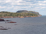
Palisade Head
Encyclopedia
.jpg)
North Shore (Lake Superior)
The North Shore of Lake Superior runs from Duluth, Minnesota, United States, at the southwestern end of the lake, to Thunder Bay and Nipigon, Ontario, Canada, in the north to Sault Ste. Marie, Ontario, in the east...
of Lake Superior
Lake Superior
Lake Superior is the largest of the five traditionally-demarcated Great Lakes of North America. It is bounded to the north by the Canadian province of Ontario and the U.S. state of Minnesota, and to the south by the U.S. states of Wisconsin and Michigan. It is the largest freshwater lake in the...
in the U.S. state
U.S. state
A U.S. state is any one of the 50 federated states of the United States of America that share sovereignty with the federal government. Because of this shared sovereignty, an American is a citizen both of the federal entity and of his or her state of domicile. Four states use the official title of...
of Minnesota
Minnesota
Minnesota is a U.S. state located in the Midwestern United States. The twelfth largest state of the U.S., it is the twenty-first most populous, with 5.3 million residents. Minnesota was carved out of the eastern half of the Minnesota Territory and admitted to the Union as the thirty-second state...
. It is within Tettegouche State Park
Tettegouche State Park
Tettegouche State Park is a Minnesota state park on the north shore of Lake Superior 58 miles northeast of Duluth in Lake County on scenic Minnesota Highway 61. The park's name stems from the Tettegouche Club, an association of local businessmen which purchased the park in 1910 from the...
but not contiguous with the rest of that park. Palisade Head is located at milepost 57 on scenic Minnesota State Highway 61
Minnesota State Highway 61
Minnesota State Highway 61 is a highway in northeast Minnesota, which runs from the junction of Interstate Highway 35 and Minnesota 61 in Duluth and continues northeast to its northern terminus at the U.S.-Canadian border near Grand Portage...
in Beaver Bay Township, Lake County
Lake County, Minnesota
Lake County is a county located in the U.S. state of Minnesota. As of 2010, the population was 10,866. Its county seat is Two Harbors. Lake County was founded on February 20, 1855, as Superior County, though its name was changed on March 3, of that year to St. Louis County. On March 1, 1856, St...
, approximately 54 miles (86 km) northeast of Duluth
Duluth, Minnesota
Duluth is a port city in the U.S. state of Minnesota and is the county seat of Saint Louis County. The fourth largest city in Minnesota, Duluth had a total population of 86,265 in the 2010 census. Duluth is also the second largest city that is located on Lake Superior after Thunder Bay, Ontario,...
and three miles (five km) east of Silver Bay
Silver Bay, Minnesota
Silver Bay is a city in Lake County, Minnesota, United States. The population was 1,887 at the 2010 census. The city was founded on May 1, 1954 after previously being known as the Beaver Bay housing project...
.
Geology
Palisade Head is formed from a rhyolitic lavaLava
Lava refers both to molten rock expelled by a volcano during an eruption and the resulting rock after solidification and cooling. This molten rock is formed in the interior of some planets, including Earth, and some of their satellites. When first erupted from a volcanic vent, lava is a liquid at...
flow which was extruded some 1.1 billion years ago. During the Mesoproterozoic
Mesoproterozoic
The Mesoproterozoic Era is a geologic era that occurred between 1600 Ma and 1000 Ma . The Mesoproterozoic was the first period of Earth's history with a respectable geological record. Continents existed in the Paleoproterozoic, but we know little about them...
era of the Precambrian
Precambrian
The Precambrian is the name which describes the large span of time in Earth's history before the current Phanerozoic Eon, and is a Supereon divided into several eons of the geologic time scale...
eon, the continent spread apart on the Midcontinent Rift System
Midcontinent Rift System
The Midcontinent Rift System or Keweenawan Rift is a long geological rift in the center of the North American continent and south-central part of the North American plate. It formed when the continent's core, the North American craton, began to split apart during the Mesoproterozoic era of the...
extending from what is now eastern Lake Superior through Duluth to Kansas; this rifting process stopped before an ocean developed. A flow some 200 feet (60 meters) thick formed extremely hard volanic rock which resisted a billion years of erosion which cut down surrounding formations. This formed both Palisade Head and Shovel Point, which is within the main part of Tettegouche State Park about two miles (three kilometers) to the east. The feature is a shallow headland
Headlands and bays
Headlands and bays are two related features of the coastal environment.- Geology and geography :Headlands and bays are often found on the same coastline. A bay is surrounded by land on three sides, whereas a headland is surrounded by water on three sides. Headlands are characterized by high,...
, with Lake Superior to the southwest, southeast, and northeast. Its high point is over 300 feet (approximately 100 meters) above the level of the lake; the lakeside cliffs stand up to several hundred feet (60 meters) above water level.
Flora and fauna
The headland is covered by a mixed forest of white spruceWhite Spruce
Picea glauca is a species of spruce native to boreal forests in the north of North America, from central Alaska east to Newfoundland, and south to northern Montana, Minnesota, Wisconsin, Michigan, upstate New York, Vermont, New Hampshire, and Maine; there is also an isolated population in the...
, mountain ash
Sorbus
Sorbus is a genus of about 100–200 species of trees and shrubs in the subfamily Maloideae of the Rose family Rosaceae. Species of Sorbus are commonly known as whitebeam, rowan, service tree, and mountain ash...
, aspen
Populus tremuloides
Populus tremuloides is a deciduous tree native to cooler areas of North America, commonly called quaking aspen, trembling aspen, American aspen, and Quakies,. The trees have tall trunks, up to 25 metres, with smooth pale bark, scarred with black. The glossy green leaves, dull beneath, become golden...
, paper birch
Paper Birch
Betula papyrifera is a species of birch native to northern North America.-Description:...
, and oak
Oak
An oak is a tree or shrub in the genus Quercus , of which about 600 species exist. "Oak" may also appear in the names of species in related genera, notably Lithocarpus...
. Raptors
Bird of prey
Birds of prey are birds that hunt for food primarily on the wing, using their keen senses, especially vision. They are defined as birds that primarily hunt vertebrates, including other birds. Their talons and beaks tend to be relatively large, powerful and adapted for tearing and/or piercing flesh....
can often be seen soaring over the cliffs. Peregrine falcons nest on Palisdade Head, Bald Eagle
Bald Eagle
The Bald Eagle is a bird of prey found in North America. It is the national bird and symbol of the United States of America. This sea eagle has two known sub-species and forms a species pair with the White-tailed Eagle...
s nest in the area, and thousands of hawks of several species can be seen migrating along the shoreline in the fall.
Trees are sparse, but there are plentiful wild blueberries
Blueberry
Blueberries are flowering plants of the genus Vaccinium with dark-blue berries and are perennial...
and, less commonly, gooseberries
Gooseberry
The gooseberry or ; Ribes uva-crispa, syn. R. grossularia) is a species of Ribes, native to Europe, northwestern Africa and southwestern Asia...
.
Human uses
Sawtooth Mountains (Minnesota)
The Sawtooth Mountains are a range of low, serrated ridges situated on the North Shore of Lake Superior in the U.S. state of Minnesota, extending about 30 miles from Carlton Peak near Tofte on the west, to Grand Marais on the east.-Description:...
to the northeast, Split Rock Lighthouse to the southwest, the Bayfield Peninsula
Bayfield Peninsula
The Bayfield Peninsula is a peninsula on Lake Superior. It is located in Bayfield County, Wisconsin USA. It is the northernmost region of mainland Wisconsin, with the south shore of Lake Superior to the west and the Chequamegon Bay to the east...
and Apostle Islands
Apostle Islands
The Apostle Islands are a group of 22 islands in Lake Superior, off the Bayfield Peninsula in northern Wisconsin. The majority of the islands are located in Ashland County—only Sand, York, Eagle, and Raspberry Islands are located in Bayfield County...
of Wisconsin
Wisconsin
Wisconsin is a U.S. state located in the north-central United States and is part of the Midwest. It is bordered by Minnesota to the west, Iowa to the southwest, Illinois to the south, Lake Michigan to the east, Michigan to the northeast, and Lake Superior to the north. Wisconsin's capital is...
across the lake to the south, and the ship traffic on Lake Superior. It is a regional center for rock climbing
Rock climbing
Rock climbing also lightly called 'The Gravity Game', is a sport in which participants climb up, down or across natural rock formations or artificial rock walls. The goal is to reach the summit of a formation or the endpoint of a pre-defined route without falling...
with many routes up the lakeshore cliffs. These cliffs were used for more sinister, albeit fictional purposes in The Good Son, partially filmed on location at Palisade Head.