

Cornwall Wildlife Trust
Encyclopedia
The Cornwall Wildlife Trust is a charitable organisation founded in 1962 that is concerned solely with Cornwall
, United Kingdom
.
It deals with the conservation and preservation of Cornwall's wildlife and habitats managing over 50 nature reserves covering approximately 4300 acres (17.4 km²), amongst them Looe Island
.
Cornwall Wildlife Trust is part of The Wildlife Trusts partnership
of 47 wildlife trusts in the United Kingdom
. It works in conjunction with the Isles of Scilly Wildlife Trust
, and jointly produces a thrice yearly magazine called Wild Cornwall & Wild Scilly
The direction and work that the Trust currently does is guided by the Cornwall Biodiversity
action plan. Living Seas and Living Landscapes are two such projects. The Trust runs ERCCIS (Environmental Records Centre for Cornwall and the Isles of Scilly), a county wide database of sightings of animals and plants. It also gives planning
advice (CEC - Cornwall Environmental Consultants) to land developers.
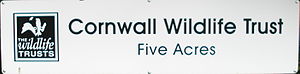
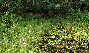
The Trust is based at Allet near Truro
in Cornwall
. The headquarters and offices are adjacent to the Trust's Five Acres nature reserve. This reserve includes two ponds, as well as mixed broadleaved woodland.
2. Baker's Pit
3. Beales Meadows
4. Bissoe Valley
5. Bosvenning Common
6. Cabilla and Redrice Woods
7. Caer Brân
8. Carn Moor
9. Chûn Downs
10. Churchtown Farm
, near Saltash
11. Chyverton
12. Devichoys Wood, near Penryn
13. Downhill Meadow
14. Fal-Ruan Estuary
15. Five Acres, at the Cornwall Wildlife Trust Headquarters, Allet, near Truro
16. Fox Corner, south of Truro
17. Greena Moor
18. Halbullock Moor, south of Truro
19. Hawkes Wood
20. Helman Tor (including Breney Common
and Red Moor
), near Lostwithiel
21. Kemyel Crease
22. Kennall Vale, at Ponsanooth
, between Falmouth
& Redruth
23. Lanvean Bottoms
24. Loggan's Moor
, near Hayle
25. Loveny/Colliford Reservoir
26. Lower Lewdon
27. Luckett/Greenscombe Wood
28. Maer Lake
29. Nansmellyn Marsh
30. North Predannack Downs
31. Park Hoskyn - The Hayman Reserve
32. Pendarves Wood, near Camborne
33. Penlee Battery
, near Kingsand
34. Phillips's Point
35. Priddacombe Downs
36. Prideaux Wood
37. Quoit Heathland
38. Redlake Cottage Meadows
39. Ropehaven Cliffs
40. Rosenannon Downs
41. St Erth Pits, at St. Erth
42. St George’s Island
(or Looe Island
), near Looe
43. Swanvale, Falmouth
44. Sylvia's Meadow
, near Callington
45. Tamar Estuary, near Saltash
46. Tincombe, near Saltash
47. Trebarwith
, near Bude
48. Tregonetha Downs, near Goss Moor
49. Tresayes, near Roche
50. Tywardreath Marsh, near Par
51. Upton Meadow, near Bude
52. Upton Towans, near St. Ives
53. Ventongimps
Moor, near Zelah, Cornwall
54. Marsland Valley
, north of Bude
55. Windmill Farm, on The Lizard
Cornwall
Cornwall is a unitary authority and ceremonial county of England, within the United Kingdom. It is bordered to the north and west by the Celtic Sea, to the south by the English Channel, and to the east by the county of Devon, over the River Tamar. Cornwall has a population of , and covers an area of...
, United Kingdom
United Kingdom
The United Kingdom of Great Britain and Northern IrelandIn the United Kingdom and Dependencies, other languages have been officially recognised as legitimate autochthonous languages under the European Charter for Regional or Minority Languages...
.
It deals with the conservation and preservation of Cornwall's wildlife and habitats managing over 50 nature reserves covering approximately 4300 acres (17.4 km²), amongst them Looe Island
Looe Island
Looe Island, also known as St George's Island, and historically St Michael's Island is a small island a mile from the mainland town of Looe in Cornwall, United Kingdom....
.
Cornwall Wildlife Trust is part of The Wildlife Trusts partnership
The Wildlife Trusts partnership
The Wildlife Trusts is an organisation made up of 47 local Wildlife Trusts in the United Kingdom plus the Isle of Man and Alderney.The Wildlife Trusts, between them, look after around 2,300 nature reserves covering more than 90,000 hectares...
of 47 wildlife trusts in the United Kingdom
United Kingdom
The United Kingdom of Great Britain and Northern IrelandIn the United Kingdom and Dependencies, other languages have been officially recognised as legitimate autochthonous languages under the European Charter for Regional or Minority Languages...
. It works in conjunction with the Isles of Scilly Wildlife Trust
Isles of Scilly Wildlife Trust
The Isles of Scilly Wildlife Trust is a wildlife trust covering the Isles of Scilly off the coast of Cornwall, England, UK.The trust works in conjunction with the Cornwall Wildlife Trust, and jointly produces a thrice yearly magazine called Wild Cornwall & Wild Scilly.It is dedicated to ensuring...
, and jointly produces a thrice yearly magazine called Wild Cornwall & Wild Scilly
The direction and work that the Trust currently does is guided by the Cornwall Biodiversity
Biodiversity
Biodiversity is the degree of variation of life forms within a given ecosystem, biome, or an entire planet. Biodiversity is a measure of the health of ecosystems. Biodiversity is in part a function of climate. In terrestrial habitats, tropical regions are typically rich whereas polar regions...
action plan. Living Seas and Living Landscapes are two such projects. The Trust runs ERCCIS (Environmental Records Centre for Cornwall and the Isles of Scilly), a county wide database of sightings of animals and plants. It also gives planning
Land use planning
Land-use planning is the term used for a branch of public policy encompassing various disciplines which seek to order and regulate land use in an efficient and ethical way, thus preventing land-use conflicts. Governments use land-use planning to manage the development of land within their...
advice (CEC - Cornwall Environmental Consultants) to land developers.
The Trust is based at Allet near Truro
Truro
Truro is a city and civil parish in Cornwall, England, United Kingdom. The city is the centre for administration, leisure and retail in Cornwall, with a population recorded in the 2001 census of 17,431. Truro urban statistical area, which includes parts of surrounding parishes, has a 2001 census...
in Cornwall
Cornwall
Cornwall is a unitary authority and ceremonial county of England, within the United Kingdom. It is bordered to the north and west by the Celtic Sea, to the south by the English Channel, and to the east by the county of Devon, over the River Tamar. Cornwall has a population of , and covers an area of...
. The headquarters and offices are adjacent to the Trust's Five Acres nature reserve. This reserve includes two ponds, as well as mixed broadleaved woodland.
List of reserves
1. Armstrong Wood2. Baker's Pit
3. Beales Meadows
4. Bissoe Valley
5. Bosvenning Common
6. Cabilla and Redrice Woods
7. Caer Brân
8. Carn Moor
9. Chûn Downs
10. Churchtown Farm
Churchtown Farm
Churchtown Farm is a community nature reserve one mile south of Saltash, Cornwall, United Kingdom. It is owned and managed by Cornwall Wildlife Trust, and includes diverse habitats such as grassland, estuarine mudflats, wetland, woodland, disused quarries and hedgerows.Situated within the Tamar...
, near Saltash
Saltash
Saltash is a town and civil parish in Cornwall, England, United Kingdom. It has a population of 14,964. It lies in the south east of Cornwall, facing Plymouth over the River Tamar. It was in the Caradon district until March 2009 and is known as "the gateway to Cornwall". Saltash means ash tree by...
11. Chyverton
12. Devichoys Wood, near Penryn
Penryn, Cornwall
Penryn is a civil parish and town in Cornwall, England, United Kingdom. It is situated on the Penryn River about one mile northwest of Falmouth...
13. Downhill Meadow
14. Fal-Ruan Estuary
15. Five Acres, at the Cornwall Wildlife Trust Headquarters, Allet, near Truro
Truro
Truro is a city and civil parish in Cornwall, England, United Kingdom. The city is the centre for administration, leisure and retail in Cornwall, with a population recorded in the 2001 census of 17,431. Truro urban statistical area, which includes parts of surrounding parishes, has a 2001 census...
16. Fox Corner, south of Truro
17. Greena Moor
18. Halbullock Moor, south of Truro
Truro
Truro is a city and civil parish in Cornwall, England, United Kingdom. The city is the centre for administration, leisure and retail in Cornwall, with a population recorded in the 2001 census of 17,431. Truro urban statistical area, which includes parts of surrounding parishes, has a 2001 census...
19. Hawkes Wood
20. Helman Tor (including Breney Common
Breney Common
Breney Common is a nature reserve and Site of Special Scientific Interest, noted for its biological interest, in central Cornwall, England, UK. It is located mainly in Lanlivery civil parish, with the Saints' Way footpath running through it....
and Red Moor
Red Moor
Red Moor is a nature reserve and Site of Special Scientific Interest , noted for its biological interest, in central Cornwall, England, UK.-Geography:...
), near Lostwithiel
Lostwithiel
Lostwithiel is a civil parish and small town in Cornwall, England, United Kingdom at the head of the estuary of the River Fowey. According to the 2001 census it had a population of 2,739...
21. Kemyel Crease
22. Kennall Vale, at Ponsanooth
Ponsanooth
Ponsanooth is a village in Cornwall, England, United Kingdom. It is situated approximately four miles south east of Redruth and two and a half miles north west of Penryn on the A393 Redruth to Falmouth road. Ponsanooth was first recorded in 1613 as Ponsanwoth Ponsanooth is a village in Cornwall,...
, between Falmouth
Falmouth, Cornwall
Falmouth is a town, civil parish and port on the River Fal on the south coast of Cornwall, England, United Kingdom. It has a total resident population of 21,635.Falmouth is the terminus of the A39, which begins some 200 miles away in Bath, Somerset....
& Redruth
Redruth
Redruth is a town and civil parish traditionally in the Penwith Hundred in Cornwall, United Kingdom. It has a population of 12,352. Redruth lies approximately at the junction of the A393 and A3047 roads, on the route of the old London to Land's End trunk road , and is approximately west of...
23. Lanvean Bottoms
24. Loggan's Moor
Loggans Moor
Loggans Moor is a nature reserve and Site of Special Scientific Interest, noted for its biological interest, in west Cornwall, England, UK. It is located 1 mile north-east of the town of Hayle, off the A30 road....
, near Hayle
Hayle
Hayle is a small town, civil parish and cargo port in west Cornwall, United Kingdom. It is situated at the mouth of the Hayle River and is approximately seven miles northeast of Penzance...
25. Loveny/Colliford Reservoir
26. Lower Lewdon
27. Luckett/Greenscombe Wood
28. Maer Lake
29. Nansmellyn Marsh
30. North Predannack Downs
Goonhilly Downs
Goonhilly Downs is a Site of Special Scientific Interest that forms a raised plateau in the central western area of the Lizard Peninsula in Cornwall, England, UK. Situated just south of Helston and the Naval Air Station at Culdrose, it is famous for its Goonhilly Satellite Earth Station, the...
31. Park Hoskyn - The Hayman Reserve
32. Pendarves Wood, near Camborne
Camborne
Camborne is a town and civil parish in west Cornwall, England, United Kingdom. It is at the western edge of a conurbation comprising Camborne, Pool and Redruth....
33. Penlee Battery
Penlee Battery
Penlee Battery is a nature reserve lying on the coastal headland of Penlee Point on the Rame Peninsula, in southeast Cornwall, United Kingdom....
, near Kingsand
Kingsand
Kingsand and Cawsand are twin villages in southeast Cornwall, United Kingdom. The villages are situated on the Rame Peninsula and in the parish of Maker-with-Rame....
34. Phillips's Point
35. Priddacombe Downs
36. Prideaux Wood
37. Quoit Heathland
38. Redlake Cottage Meadows
Redlake Cottage Meadows
Redlake Meadows & Hoggs Moor is a Site of Special Scientific Interest , noted for its biological interest, in Cornwall, England, UK. Within the SSSI is Redlake Cottage Meadows nature reserve owned by the Cornwall Wildlife Trust.-Geography:...
39. Ropehaven Cliffs
40. Rosenannon Downs
41. St Erth Pits, at St. Erth
42. St George’s Island
Looe Island
Looe Island, also known as St George's Island, and historically St Michael's Island is a small island a mile from the mainland town of Looe in Cornwall, United Kingdom....
(or Looe Island
Looe Island
Looe Island, also known as St George's Island, and historically St Michael's Island is a small island a mile from the mainland town of Looe in Cornwall, United Kingdom....
), near Looe
Looe
Looe is a small coastal town, fishing port and civil parish in the former Caradon district of south-east Cornwall, England, with a population of 5,280 . Looe is divided in two by the River Looe, East Looe and West Looe being connected by a bridge...
43. Swanvale, Falmouth
Falmouth, Cornwall
Falmouth is a town, civil parish and port on the River Fal on the south coast of Cornwall, England, United Kingdom. It has a total resident population of 21,635.Falmouth is the terminus of the A39, which begins some 200 miles away in Bath, Somerset....
44. Sylvia's Meadow
Sylvia's Meadow
Sylvia's Meadow, a Site of Special Scientific Interest, is a nature reserve owned and managed by Cornwall Wildlife Trust. It is a herb rich, site situated near Gunnislake, in East Cornwall, United Kingdom.-History:...
, near Callington
45. Tamar Estuary, near Saltash
Saltash
Saltash is a town and civil parish in Cornwall, England, United Kingdom. It has a population of 14,964. It lies in the south east of Cornwall, facing Plymouth over the River Tamar. It was in the Caradon district until March 2009 and is known as "the gateway to Cornwall". Saltash means ash tree by...
46. Tincombe, near Saltash
Saltash
Saltash is a town and civil parish in Cornwall, England, United Kingdom. It has a population of 14,964. It lies in the south east of Cornwall, facing Plymouth over the River Tamar. It was in the Caradon district until March 2009 and is known as "the gateway to Cornwall". Saltash means ash tree by...
47. Trebarwith
Trebarwith Strand
Trebarwith Strand , is a coastal settlement and section of coastline located on the north coast of Cornwall, United Kingdom, 2½ miles south of Tintagel...
, near Bude
Bude
Bude is a small seaside resort town in North Cornwall, England, at the mouth of the River Neet . It lies just south of Flexbury, north of Widemouth Bay and west of Stratton and is located along the A3073 road off the A39. Bude is twinned with Ergué-Gabéric in Brittany, France...
48. Tregonetha Downs, near Goss Moor
49. Tresayes, near Roche
Roche, Cornwall
Roche is a civil parish and village in mid-Cornwall, England, United Kingdom. The village gets its name from a granite outcrop east of the village. Roche is the Norman-French word for Rock....
50. Tywardreath Marsh, near Par
Par, Cornwall
Par is a town and fishing port with a harbour on the south coast of Cornwall, England, United Kingdom. The town is situated in the civil parish of Tywardreath and Par and is approximately east of St Austell. Par has a population of around 1,400.....
51. Upton Meadow, near Bude
Bude
Bude is a small seaside resort town in North Cornwall, England, at the mouth of the River Neet . It lies just south of Flexbury, north of Widemouth Bay and west of Stratton and is located along the A3073 road off the A39. Bude is twinned with Ergué-Gabéric in Brittany, France...
52. Upton Towans, near St. Ives
St Ives, Cornwall
St Ives is a seaside town, civil parish and port in Cornwall, England, United Kingdom. The town lies north of Penzance and west of Camborne on the coast of the Celtic Sea. In former times it was commercially dependent on fishing. The decline in fishing, however, caused a shift in commercial...
53. Ventongimps
Ventongimps
Ventongimps is a hamlet in Cornwall, England, UK....
Moor, near Zelah, Cornwall
Zelah, Cornwall
Zelah is a village in Cornwall, United Kingdom approximately 5 miles north of Truro. Zelah is the largest settlement in the civil parish of St Allen...
54. Marsland Valley
Marsland Valley
Marsland Valley is a nature reserve situated in two large valleys which straddle the Devon-Cornwall border. It is a designated nature reserve jointly managed by the Devon Wildlife Trust and the Cornwall Wildlife Trust...
, north of Bude
Bude
Bude is a small seaside resort town in North Cornwall, England, at the mouth of the River Neet . It lies just south of Flexbury, north of Widemouth Bay and west of Stratton and is located along the A3073 road off the A39. Bude is twinned with Ergué-Gabéric in Brittany, France...
55. Windmill Farm, on The Lizard
The Lizard
The Lizard is a peninsula in south Cornwall, England, United Kingdom. The most southerly point of the British mainland is near Lizard Point at ....
External links