

Puyehue-Cordón Caulle
Encyclopedia
Puyehue and Cordón Caulle (k) are two coalesced volcanic edifices that form a major mountain massif
in Puyehue National Park
in the Andes
of Ranco Province
, Chile
. In volcanology
this group is known as the Puyehue-Cordón Caulle Volcanic Complex (PCCVC). Four different volcanoes constitute the volcanic group or complex, the Cordillera Nevada caldera
, the Pliocene
Mencheca volcano, Cordón Caulle fissure vent
s and the Puyehue stratovolcano
. As with most stratovolcanoes on the Southern Volcanic Zone of the Andes, Puyehue and Cordón Caulle are located along the intersection of a traverse fault
with the larger north-south Liquiñe-Ofqui Fault
. The volcanic complex has shaped the local landscape and produced a huge variety of volcanic landforms and products over the last 300,000 years. Cinder cone
s, lava dome
s, caldera
s and craters can be found in the area apart from the widest variety of volcanic rock
s in all the Southern Volcanic Zone, for example both primitive
basalt
s and rhyolite
s. Cordón Caulle is notable for having erupted following the 1960 Valdivia earthquake, the largest recorded earthquake in history.
Apart from this, the Puyehue-Cordón Caulle area is one of the main sites of exploration for geothermal power
in Chile. Geothermal activity is manifested on the surface of Puyehue and Cordón Caulle as several boiling spring
s, solfataras and fumarole
s.
Renewed activity at the volcano resulted in the highest alert level, 4, being declared on 3 June 2011. A new eruption started on 3 June, 20:30 UTC. On 4 June the ash cloud reached a height of 12000 metres (39,370.1 ft).
in the Ranco Province
of the Andes. The three volcanoes are coalesced
. Puyehue is located in the southeast, Cordón Caulle in the center, and Cordillera Nevada, which owes its name to its often snowy appearance from the relatively densely populated Chilean Central Valley
, is at the northwestern end. The massif is located between two lakes, Ranco Lake
in the north and Puyehue Lake
in the south. The fact that Puyehue volcano is named after Puyehue Lake reflects that it is better seen and more accessible from the south. Cordillera Nevada is a 9 kilometres (6 mi) wide semicircular caldera
and corresponds to the remnants of a collapsed volcano. Cordillera Nevada covers an approximate area of 700 square kilometres (172,974 acre). Cordón Caulle is a northwest trending ridge that hosts a volcanic-tectonic graben
in which a fissure vent
is developed. Cordón Caulle's summits collectively lie above the tree line, with the highest point reaching 1798 metres (5,899 ft). Puyehue Volcano is a stratovolcano
located on the southeastern end of Cordón Caulle, just east of the main fault of the Liquiñe-Ofqui Fault Zone. Its cone hosts a 2.4 km (1.5 mi) wide crater, and products of Puyehue volcanism cover an approximate area of 160 km² (62 sq mi).
plant association
of Valdivian temperate rainforest, where plant species such as Chusquea coleou and Nothofagus dombeyi are common. The tree line, lying around 1500 m (4,921 ft) elevation, is mostly Nothofagus pumilio. Above this line lies volcanic desert
and alpine tundra
. The main plant species present in these high elevations are Gaultheria mucronata
, Empetrum rubrum
, Hordeum comosun and Cissus striata
.
 The volcanic complex that comprises Puyehue, Cordón Caulle and Cordillera Nevada has a long record of active history spanning from 300,000 years ago
to the present. The older parts of the Cordillera Nevada caldera and Mencheca volcano reflect even older activity from the Pliocene
or the early Pleistocene
. In the past 300,000 years, there have been a series of changes in magmatic composition, locus of volcanic activity, magma output rates and eruptive styles.
and Lanín
. The relocation of the active front gave rise to new volcanoes further westward or increased their activity. The formerly broad magmatic belt narrowed, retaining vigorous activity only in its westernmost parts. Associated with these changes are the oldest rocks of PCCVC, those that belong to Sierra Nevada. Sierra Nevada grew over time to form a large shield volcano
, during the same time Cordón Caulle was also being built up having rather silicic products compared to coeval Sierra Nevada and Mencheca. The oldest rocks from proper Puyehue volcano are 200,000 years old, representing the youngest possible age for this volcano.
It is estimated that some 100,000 years ago in the period between Río Llico and Llanquihue glaciation a large ignimbrite
called San Pablo was produced. This ignimbrite covers an estimated area of 1500 square kilometres (370,658 acre) immediately west of Cordillera Nevada, stretching across the Chilean Central Valley
almost reaching the Chilean Coast Range. The San Pablo ignimbrite has been associated with the formation of the Cordillera Nevada Caldera.
, leaving glacial striae on many lava outcrops and affecting the volcanic activity.
In Cordillera Nevada this volcanism was expressed from about 117,000 years ago primarily as dacitic
lava flows erupted along ring faults
. These lava flows partly filled the caldera and flowed north, out to what is now Nilahue River
. In mid or late glacial times cordillera Nevada produced its last lavas which were andesitic to dacitic in composition. Cordón Caulle evolved during this time from being a shield volcano to a graben
with fissure vent
s. This was accompanied by emission of ignimbrites and dacitic lava flows.
Puyehue was characterized by eruption of basaltic andesite
s to dacites until its activity turned bimodal
at around 34,000 years ago. The onset of this change was marked by the eruption of rhyodacite
mingled with basaltic andesite rich in magnesium oxide
(MgO). The bimodal activity continued with a small hiatus
around 30,000 years ago until around 19,000 years ago when Puyehues started to produce lava domes and flows of dacitic to rhyolitic composition, a trend that lasted until 12,000 years before present. Between 15,000 and 12,000 years ago Puyehue also erupted basaltic andesite. During the Llanquihue glaciation Puyehue volcano produced some of the most primitive
basalts of the Southern Volcanic Zone with a magnesium oxide mass percentage of 14.32, which is in equilibrium
with melt from mantle
peridotite
.
 Only Puyehue and Cordón Caulle have erupted during the Holocene
, and until 2011 only Cordón Caulle had recorded historical eruptions. In the interval between 7,000 to 5,000 years ago Puyehue had rhyolitic eruptions that produced lava dome
s. The lava domes were later destroyed after a sequence of strong eruptions that were part of a explosive eruptive cycle. These last eruptions were likely of phreatomagmatic
and sub-plinian type and occurred around 1,100 years ago (~850 CE).
in 1558, the only Spanish settlement in the zone, 80 kilometres (50 mi) west of Cordón Caulle. This settlements had to be abandoned in 1602 due to conflicts with native Huilliche
s. No eruption record is known from this era. From 1602 to the mid 18th century there were no Spanish settlements within a radius of 100 kilometres (62 mi). The closest were Valdivia
and the sporadic missions of Nahuel Huapi all of them out of sight of the volcano. In 1759 an eruption was noticed in the Cordillera, although this is mainly attributed to Mocho
. By the end of the 19th century most of the Central Valley
west of Cordón Caulle had been settled by Chileans and European immigrants and an eruption was reported in 1893. The next report came in 1905, but the eruption of 08 February 1914 is the first one certain to have occurred.
, with a 6.2 kilometres (4 mi) high plume, periodic explosions and seismicity. The eruption had a Volcanic Explosivity Index
of 3 and ended on February 1922. In 1929 and 1934 the Cordón Caulle had fissure eruptions, both with an estimated Volcanic Explosivity Index
of 2.
fissure eruption. The earthquake had struck the whole of Chile between Talca
(30°S) and Chiloé
(43°S) and had an estimated moment magnitude
of 9.5. Being located between two sparsely populated and by then isolated Andean valleys the eruption had few eyewitnesses and received little attention by local media due to the huge damages and losses caused by the main earthquake. The eruption was fed by a 5.5 kilometres (3 mi) long and north west-west (N135°) trending fissure along which 21 individual vents have been found. These vents produced an output of about 0.25km3 DRE both in form of lava flows and tephra
.
The eruption began in a sub-plinian style
creating a column of volcanic gas
, pyroclasts and ash
about 8 km in height. The erupting N135° trending fissure had two craters of major activity emplaced at each end; the Gris Crater and El Azufral Crater. Volcanic vents of Cordón Caulle that were not in eruption produced visible steam
emissions. After this explosive phase the eruption changed character to a more effusive one marked by rhyodacitic blocky and [[ʻAʻā|Aa]] type lava flows emitted from the vents along the N135° trending fissure. A third phase followed with the appearance of short north-north west (N165°) oriented vents transverse to the main fissure which also erupted rhyodacitic lava. The third phase ended temporarily with viscous lava obstructing the vents, but continued soon with explosive activity restricted to the Gris and El Azufral craters. The eruption came to an end on July 22.
(Oficina Nacional de Emergencia del Ministerio del Interior) organized a flight over the area with two volcanologist
s aboard. Puyehue and Cordón Caulle as well the Carrán crater
were found without activity. From accounts of local inhabitants of the area it is inferred that a small pumice cone was formed around 1990. In 1994 a temporarily emplaced seismic network registered tremors north of Puyehue's cone which reached IV and V degrees on the Mercalli intensity scale
. This prompted ONEMI to invoke an emergency action committee, however soon afterward unrest ceased. Between May 4 and 17 of 2011 seismic activity partly attributed to the movements of fluids was detected Southern Andean Volcano Observatory
(OVDAS). The activity concentrated around and in Cordillera Nevada caldera
and on western Cordón Caulle. This prompted SERNAGEOMIN-OVDAS to declare yellow alert.
, where the local airport was closed. At approximately 16:30 local time, Neuquén airport
further east in Argentina was also closed due to the ash cloud. Airports as far away as Buenos Aires
and Melbourne
, Australia had to be closed temporarily due to volcanic ash.
By 15 June a dense column of ash was still erupting 9km into the air, with the ash cloud spreading across the Southern Hemisphere; scientists expected intensifying eruptions of Puyehue in the following days, and said the volcano showed no signs of slowing down.
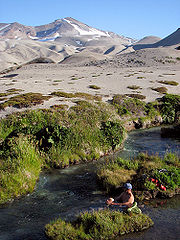 Cordón Caulle is a major area of geothermal
activity, as manifested by the several hot spring
s, boiling springs, solfataras and fumarole
s that develop on it. The geothermal system in Cordón Caulle consists of a vapour dominated system overlain by a more superficial steam heated aquifer
. The temperatures of the vapour systems range from 260–340 °C and 150–180 °C for the aquifer. The uppermost part of the geothermal system, at 1500–2000 m (4,921–6,562 ft), is characterized by fumaroles and acid-sulfate
springs.
Cordón Caulle is considered one of the main sites of geothermal exploration in Chile.
, which goes from Osorno
to Bariloche in Argentina
through Samoré Pass
. Some 1,000 m up on forested slope there is a campsite and mountain shelter. According to the homepage of Puyehue National Park the shelter can be reached after four hours walking. The access trough El Caulle is not public as it is not inside Puyehue National Park
; and an entrance fee of 10,000 CLP
, as of 2009, has to be paid, of which 3,000 are refunded if visitor packs out his garbage. From the north, there are tracks from the vicinities of Nilahue Valley
near Ranco Lake
. The track ascends ca 1,000 m through dense forest to the Cordón Caulle area. From the relatively flat Cordón Caulle there is further ca 600 m of ascent over tephra
and loose rocks to the summit of Puyehue. In the Nilahue area there are arriero
s who offer horseback trips to Cordón Caulle.
Massif
In geology, a massif is a section of a planet's crust that is demarcated by faults or flexures. In the movement of the crust, a massif tends to retain its internal structure while being displaced as a whole...
in Puyehue National Park
Puyehue National Park
Puyehue National Park is located in the Andes, in Los Ríos and Los Lagos Region of Chile. It covers . The Route 215 passes through the park. It connects with the Argentine Route 231 via Cardenal Antonio Samoré Pass....
in the Andes
Andes
The Andes is the world's longest continental mountain range. It is a continual range of highlands along the western coast of South America. This range is about long, about to wide , and of an average height of about .Along its length, the Andes is split into several ranges, which are separated...
of Ranco Province
Ranco Province
Ranco Province is one of two provinces of the southern Chilean region of Los Ríos . It is named after Ranco Lake shared by the communes of Futrono and Lago Ranco. The lake is drained by the Bueno River, on which basin lies most of the province...
, Chile
Chile
Chile ,officially the Republic of Chile , is a country in South America occupying a long, narrow coastal strip between the Andes mountains to the east and the Pacific Ocean to the west. It borders Peru to the north, Bolivia to the northeast, Argentina to the east, and the Drake Passage in the far...
. In volcanology
Volcanology
Volcanology is the study of volcanoes, lava, magma, and related geological, geophysical and geochemical phenomena. The term volcanology is derived from the Latin word vulcan. Vulcan was the ancient Roman god of fire....
this group is known as the Puyehue-Cordón Caulle Volcanic Complex (PCCVC). Four different volcanoes constitute the volcanic group or complex, the Cordillera Nevada caldera
Caldera
A caldera is a cauldron-like volcanic feature usually formed by the collapse of land following a volcanic eruption, such as the one at Yellowstone National Park in the US. They are sometimes confused with volcanic craters...
, the Pliocene
Pliocene
The Pliocene Epoch is the period in the geologic timescale that extends from 5.332 million to 2.588 million years before present. It is the second and youngest epoch of the Neogene Period in the Cenozoic Era. The Pliocene follows the Miocene Epoch and is followed by the Pleistocene Epoch...
Mencheca volcano, Cordón Caulle fissure vent
Fissure vent
A fissure vent, also known as a volcanic fissure or simply fissure, is a linear volcanic vent through which lava erupts, usually without any explosive activity. The vent is usually a few meters wide and may be many kilometers long. Fissure vents can cause large flood basalts and lava channels...
s and the Puyehue stratovolcano
Stratovolcano
A stratovolcano, also known as a composite volcano, is a tall, conical volcano built up by many layers of hardened lava, tephra, pumice, and volcanic ash. Unlike shield volcanoes, stratovolcanoes are characterized by a steep profile and periodic, explosive eruptions...
. As with most stratovolcanoes on the Southern Volcanic Zone of the Andes, Puyehue and Cordón Caulle are located along the intersection of a traverse fault
Geologic fault
In geology, a fault is a planar fracture or discontinuity in a volume of rock, across which there has been significant displacement along the fractures as a result of earth movement. Large faults within the Earth's crust result from the action of tectonic forces...
with the larger north-south Liquiñe-Ofqui Fault
Liquiñe-Ofqui Fault
The Liquiñe-Ofqui Fault is major geological fault that runs a length of roughly 1000 km in a north-south direction and exhibits current seismicity . It is located in the Chilean northern patagonean Andes. It is a dextral intra-arc transform fault...
. The volcanic complex has shaped the local landscape and produced a huge variety of volcanic landforms and products over the last 300,000 years. Cinder cone
Cinder cone
According to the , Cinder Cone is the proper name of 1 cinder cone in Canada and 7 cinder cones in the United States:In Canada: Cinder Cone In the United States:...
s, lava dome
Lava dome
|250px|thumb|right|Image of the [[rhyolitic]] lava dome of [[Chaitén Volcano]] during its 2008–2009 eruption.In volcanology, a lava dome is a roughly circular mound-shaped protrusion resulting from the slow extrusion of viscous lava from a volcano...
s, caldera
Caldera
A caldera is a cauldron-like volcanic feature usually formed by the collapse of land following a volcanic eruption, such as the one at Yellowstone National Park in the US. They are sometimes confused with volcanic craters...
s and craters can be found in the area apart from the widest variety of volcanic rock
Volcanic rock
Volcanic rock is a rock formed from magma erupted from a volcano. In other words, it is an igneous rock of volcanic origin...
s in all the Southern Volcanic Zone, for example both primitive
Igneous differentiation
In geology, igneous differentiation is an umbrella term for the various processes by which magmas undergo bulk chemical change during the partial melting process, cooling, emplacement or eruption.-Primary melts:...
basalt
Basalt
Basalt is a common extrusive volcanic rock. It is usually grey to black and fine-grained due to rapid cooling of lava at the surface of a planet. It may be porphyritic containing larger crystals in a fine matrix, or vesicular, or frothy scoria. Unweathered basalt is black or grey...
s and rhyolite
Rhyolite
This page is about a volcanic rock. For the ghost town see Rhyolite, Nevada, and for the satellite system, see Rhyolite/Aquacade.Rhyolite is an igneous, volcanic rock, of felsic composition . It may have any texture from glassy to aphanitic to porphyritic...
s. Cordón Caulle is notable for having erupted following the 1960 Valdivia earthquake, the largest recorded earthquake in history.
Apart from this, the Puyehue-Cordón Caulle area is one of the main sites of exploration for geothermal power
Geothermal power
Geothermal energy is thermal energy generated and stored in the Earth. Thermal energy is the energy that determines the temperature of matter. Earth's geothermal energy originates from the original formation of the planet and from radioactive decay of minerals...
in Chile. Geothermal activity is manifested on the surface of Puyehue and Cordón Caulle as several boiling spring
Hot spring
A hot spring is a spring that is produced by the emergence of geothermally heated groundwater from the Earth's crust. There are geothermal hot springs in many locations all over the crust of the earth.-Definitions:...
s, solfataras and fumarole
Fumarole
A fumarole is an opening in a planet's crust, often in the neighborhood of volcanoes, which emits steam and gases such as carbon dioxide, sulfur dioxide, hydrochloric acid, and hydrogen sulfide. The steam is created when superheated water turns to steam as its pressure drops when it emerges from...
s.
Renewed activity at the volcano resulted in the highest alert level, 4, being declared on 3 June 2011. A new eruption started on 3 June, 20:30 UTC. On 4 June the ash cloud reached a height of 12000 metres (39,370.1 ft).
Geography
Puyehue, Cordón del Caulle, and Cordillera Nevada form a northwest trending massifMassif
In geology, a massif is a section of a planet's crust that is demarcated by faults or flexures. In the movement of the crust, a massif tends to retain its internal structure while being displaced as a whole...
in the Ranco Province
Ranco Province
Ranco Province is one of two provinces of the southern Chilean region of Los Ríos . It is named after Ranco Lake shared by the communes of Futrono and Lago Ranco. The lake is drained by the Bueno River, on which basin lies most of the province...
of the Andes. The three volcanoes are coalesced
Complex volcano
A complex volcano, also called a compound volcano, is a volcano with more than one feature. They form because changes of their eruptive characteristics or the location of multiple vents in an area...
. Puyehue is located in the southeast, Cordón Caulle in the center, and Cordillera Nevada, which owes its name to its often snowy appearance from the relatively densely populated Chilean Central Valley
Chilean Central Valley
The Central Valley , Intermediate Depression or Longitudinal Valley is the depression between the Chilean Costal Range and the Andes Mountains. The central valley should not be confused with Central Chile that encompasses part of the valley...
, is at the northwestern end. The massif is located between two lakes, Ranco Lake
Ranco Lake
Ranco Lake is located in Ranco Province of Chile. It is the largest lake of Los Ríos Region and the fourth largest in Chile. Administratively Ranco Lake is split into three communes; La Unión, Futrono and Lago Ranco. The lake host a series of islands of which Guapi Island is the largest. The...
in the north and Puyehue Lake
Puyehue Lake
Puyehue Lake is an Andean piedmont lake located in the border of Los Lagos Region with Los Ríos Region of Chile...
in the south. The fact that Puyehue volcano is named after Puyehue Lake reflects that it is better seen and more accessible from the south. Cordillera Nevada is a 9 kilometres (6 mi) wide semicircular caldera
Caldera
A caldera is a cauldron-like volcanic feature usually formed by the collapse of land following a volcanic eruption, such as the one at Yellowstone National Park in the US. They are sometimes confused with volcanic craters...
and corresponds to the remnants of a collapsed volcano. Cordillera Nevada covers an approximate area of 700 square kilometres (172,974 acre). Cordón Caulle is a northwest trending ridge that hosts a volcanic-tectonic graben
Graben
In geology, a graben is a depressed block of land bordered by parallel faults. Graben is German for ditch. Graben is used for both the singular and plural....
in which a fissure vent
Fissure vent
A fissure vent, also known as a volcanic fissure or simply fissure, is a linear volcanic vent through which lava erupts, usually without any explosive activity. The vent is usually a few meters wide and may be many kilometers long. Fissure vents can cause large flood basalts and lava channels...
is developed. Cordón Caulle's summits collectively lie above the tree line, with the highest point reaching 1798 metres (5,899 ft). Puyehue Volcano is a stratovolcano
Stratovolcano
A stratovolcano, also known as a composite volcano, is a tall, conical volcano built up by many layers of hardened lava, tephra, pumice, and volcanic ash. Unlike shield volcanoes, stratovolcanoes are characterized by a steep profile and periodic, explosive eruptions...
located on the southeastern end of Cordón Caulle, just east of the main fault of the Liquiñe-Ofqui Fault Zone. Its cone hosts a 2.4 km (1.5 mi) wide crater, and products of Puyehue volcanism cover an approximate area of 160 km² (62 sq mi).
Flora
The lower parts of the mountains are covered by an alpineAlpine climate
Alpine climate is the average weather for a region above the tree line. This climate is also referred to as mountain climate or highland climate....
plant association
Phytocoenosis
Plant community is a collection of plant species within a designated geographical unit, which forms a relatively uniform patch, distinguishable from neighbouring patches of different vegetation types. The components of each plant community are influenced by soil type, topography, climate and human...
of Valdivian temperate rainforest, where plant species such as Chusquea coleou and Nothofagus dombeyi are common. The tree line, lying around 1500 m (4,921 ft) elevation, is mostly Nothofagus pumilio. Above this line lies volcanic desert
Volcanic desert
A volcanic desert is an area devoid of vegetation because of volcanic activity. Usually the term is applied to larger areas such as the Highlands of Iceland or Cordón Caulle in Chile. Volcanic deserts may have enough precipitation to sustain vegetation, but due to repeated covering of tephra after...
and alpine tundra
Alpine tundra
Alpine tundra is a natural region that does not contain trees because it is at high altitude. Alpine tundra is distinguished from arctic tundra, because alpine soils are generally better drained than arctic soils...
. The main plant species present in these high elevations are Gaultheria mucronata
Gaultheria mucronata
Gaultheria mucronata is a species of plant in the family Ericaceae, is a native to southern Argentina and Chile. It produces purple plum-shaped fruits. Commonly known as "Chaura". While the fruits are edible, they are sweet and somewhat tasteless. In North America this frost-tolerant species is...
, Empetrum rubrum
Empetrum rubrum
Empetrum rubrum, known as red crowberry or Diddle-Dee , is a species of plant in the Ericaceae family with a distributional range in Chile from Talca to Cape Horn ; in areas of adjacent Argentina; in the Falkland Islands; and in Tristan da Cunha. One of its northernmost natural growing places is...
, Hordeum comosun and Cissus striata
Cissus striata
Cissus striata is a climbing plant of the vitaceae family. The plant is found in south-central Chile with a distribution range from Coquimbo to Los Lagos Region. It is also found in Argentina, Brazil, Uruguay, Paraguay and Bolivia. It has a woody stem that looks reddish when it gets older...
.
Geologic history
Before Present
Before Present years is a time scale used in archaeology, geology, and other scientific disciplines to specify when events in the past occurred. Because the "present" time changes, standard practice is to use AD 1950 as the origin of the age scale, reflecting the fact that radiocarbon...
to the present. The older parts of the Cordillera Nevada caldera and Mencheca volcano reflect even older activity from the Pliocene
Pliocene
The Pliocene Epoch is the period in the geologic timescale that extends from 5.332 million to 2.588 million years before present. It is the second and youngest epoch of the Neogene Period in the Cenozoic Era. The Pliocene follows the Miocene Epoch and is followed by the Pleistocene Epoch...
or the early Pleistocene
Pleistocene
The Pleistocene is the epoch from 2,588,000 to 11,700 years BP that spans the world's recent period of repeated glaciations. The name pleistocene is derived from the Greek and ....
. In the past 300,000 years, there have been a series of changes in magmatic composition, locus of volcanic activity, magma output rates and eruptive styles.
Ancestral volcanoes
Some 300,000 years ago, important changes occurred in the area of Puyehue. The old Pliocene volcano Mencheca, currently exposed just northeast of Puyehue's cone, declined in activity. This decline was probably due a regional change in the location of the active front of the Southern Volcanic Zone that also affected other volcanoes such as TronadorTronador
Tronador is an extinct stratovolcano in the southern Andes, located along the border between Argentina and Chile near the city of Bariloche. The mountain was named Tronador by locals in reference to the sound of falling seracs...
and Lanín
Lanín
Lanín is an ice-clad, cone-shaped stratovolcano on the border of Argentina and Chile. It forms part of two national parks: Lanín in Argentina and Villarrica in Chile. It is a symbol of the Argentine province of Neuquén, being part of its flag and its anthem. Although the date of its last eruption...
. The relocation of the active front gave rise to new volcanoes further westward or increased their activity. The formerly broad magmatic belt narrowed, retaining vigorous activity only in its westernmost parts. Associated with these changes are the oldest rocks of PCCVC, those that belong to Sierra Nevada. Sierra Nevada grew over time to form a large shield volcano
Shield volcano
A shield volcano is a type of volcano usually built almost entirely of fluid lava flows. They are named for their large size and low profile, resembling a warrior's shield. This is caused by the highly fluid lava they erupt, which travels farther than lava erupted from more explosive volcanoes...
, during the same time Cordón Caulle was also being built up having rather silicic products compared to coeval Sierra Nevada and Mencheca. The oldest rocks from proper Puyehue volcano are 200,000 years old, representing the youngest possible age for this volcano.
It is estimated that some 100,000 years ago in the period between Río Llico and Llanquihue glaciation a large ignimbrite
Ignimbrite
An ignimbrite is the deposit of a pyroclastic density current, or pyroclastic flow, a hot suspension of particles and gases that flows rapidly from a volcano, driven by a greater density than the surrounding atmosphere....
called San Pablo was produced. This ignimbrite covers an estimated area of 1500 square kilometres (370,658 acre) immediately west of Cordillera Nevada, stretching across the Chilean Central Valley
Chilean Central Valley
The Central Valley , Intermediate Depression or Longitudinal Valley is the depression between the Chilean Costal Range and the Andes Mountains. The central valley should not be confused with Central Chile that encompasses part of the valley...
almost reaching the Chilean Coast Range. The San Pablo ignimbrite has been associated with the formation of the Cordillera Nevada Caldera.
Volcanism during the Llanquihue glaciation
During the Llanquihue glaciation volcanism occurred on all three vents, Cordillera Nevada, Cordón Caulle and Puyehue volcano. During most of this time the volcano was covered by the Patagonian Ice SheetPatagonian Ice Sheet
350px|thumb|right|Map showing the extent of the Patagonian Ice Sheet in the [[Strait of Magellan]] area during the [[last glacial period]]. Selected modern settlements are shown with yellow dots...
, leaving glacial striae on many lava outcrops and affecting the volcanic activity.
In Cordillera Nevada this volcanism was expressed from about 117,000 years ago primarily as dacitic
Dacite
Dacite is an igneous, volcanic rock. It has an aphanitic to porphyritic texture and is intermediate in composition between andesite and rhyolite. The relative proportions of feldspars and quartz in dacite, and in many other volcanic rocks, are illustrated in the QAPF diagram...
lava flows erupted along ring faults
Caldera
A caldera is a cauldron-like volcanic feature usually formed by the collapse of land following a volcanic eruption, such as the one at Yellowstone National Park in the US. They are sometimes confused with volcanic craters...
. These lava flows partly filled the caldera and flowed north, out to what is now Nilahue River
Nilahue River
Nilahue River is an Andean river in Lago Ranco commune in south-central Chile. Nilahue River originates in Cordón Caulle volcano and discharges into Ranco Lake, being its second largest tributary after Calcurrupe River. The catchment basin of the river receives water both from rainfall and from...
. In mid or late glacial times cordillera Nevada produced its last lavas which were andesitic to dacitic in composition. Cordón Caulle evolved during this time from being a shield volcano to a graben
Graben
In geology, a graben is a depressed block of land bordered by parallel faults. Graben is German for ditch. Graben is used for both the singular and plural....
with fissure vent
Fissure vent
A fissure vent, also known as a volcanic fissure or simply fissure, is a linear volcanic vent through which lava erupts, usually without any explosive activity. The vent is usually a few meters wide and may be many kilometers long. Fissure vents can cause large flood basalts and lava channels...
s. This was accompanied by emission of ignimbrites and dacitic lava flows.
Puyehue was characterized by eruption of basaltic andesite
Basaltic andesite
Basaltic andesite is a black volcanic rock containing about 55% silica. Minerals in basaltic andesite include olivine, augite and plagioclase. Basaltic andesite can be found in volcanoes around the world, including in Central America and the Andes of South America. Basaltic andesite is common in...
s to dacites until its activity turned bimodal
Bimodal volcanism
Bimodal volcanism refers to the eruption of both mafic and felsic lavas from a single volcanic centre with little or no lavas of intermediate composition...
at around 34,000 years ago. The onset of this change was marked by the eruption of rhyodacite
Rhyodacite
Rhyodacite is an extrusive volcanic rock intermediate in composition between dacite and rhyolite. It is the extrusive equivalent of granodiorite. Phenocrysts of sodium rich plagioclase, sanidine, quartz, and biotite or hornblende are typically set in an aphanitic to glassy light to intermediate...
mingled with basaltic andesite rich in magnesium oxide
Magnesium oxide
Magnesium oxide , or magnesia, is a white hygroscopic solid mineral that occurs naturally as periclase and is a source of magnesium . It has an empirical formula of and consists of a lattice of Mg2+ ions and O2– ions held together by ionic bonds...
(MgO). The bimodal activity continued with a small hiatus
Hiatus
Hiatus may refer to:*Recess *Hiatus, a small difference in pitch between two musical tones *Hiatus , a phonological term referring to the lack of a consonant separating two vowels in separate syllables, as in co-operation*Hiatus , a break of several weeks or more in television scheduling*Hiatus...
around 30,000 years ago until around 19,000 years ago when Puyehues started to produce lava domes and flows of dacitic to rhyolitic composition, a trend that lasted until 12,000 years before present. Between 15,000 and 12,000 years ago Puyehue also erupted basaltic andesite. During the Llanquihue glaciation Puyehue volcano produced some of the most primitive
Bowen's reaction series
Within the field of geology, Bowen's reaction series is the work of the petrologist, Norman L. Bowen who was able to explain why certain types of minerals tend to be found together while others are almost never associated with one another...
basalts of the Southern Volcanic Zone with a magnesium oxide mass percentage of 14.32, which is in equilibrium
Chemical equilibrium
In a chemical reaction, chemical equilibrium is the state in which the concentrations of the reactants and products have not yet changed with time. It occurs only in reversible reactions, and not in irreversible reactions. Usually, this state results when the forward reaction proceeds at the same...
with melt from mantle
Mantle (geology)
The mantle is a part of a terrestrial planet or other rocky body large enough to have differentiation by density. The interior of the Earth, similar to the other terrestrial planets, is chemically divided into layers. The mantle is a highly viscous layer between the crust and the outer core....
peridotite
Peridotite
A peridotite is a dense, coarse-grained igneous rock, consisting mostly of the minerals olivine and pyroxene. Peridotite is ultramafic, as the rock contains less than 45% silica. It is high in magnesium, reflecting the high proportions of magnesium-rich olivine, with appreciable iron...
.
Postglacial volcanism
Holocene
The Holocene is a geological epoch which began at the end of the Pleistocene and continues to the present. The Holocene is part of the Quaternary period. Its name comes from the Greek words and , meaning "entirely recent"...
, and until 2011 only Cordón Caulle had recorded historical eruptions. In the interval between 7,000 to 5,000 years ago Puyehue had rhyolitic eruptions that produced lava dome
Lava dome
|250px|thumb|right|Image of the [[rhyolitic]] lava dome of [[Chaitén Volcano]] during its 2008–2009 eruption.In volcanology, a lava dome is a roughly circular mound-shaped protrusion resulting from the slow extrusion of viscous lava from a volcano...
s. The lava domes were later destroyed after a sequence of strong eruptions that were part of a explosive eruptive cycle. These last eruptions were likely of phreatomagmatic
Phreatomagmatic eruption
Phreatomagmatic eruptions are defined as juvenile forming eruptions as a result of interaction between water and magma. They are different from magmatic and phreatic eruptions. The products of phreatomagmatic eruptions contain juvenile clasts, unlike phreatic eruptions, and are the result of...
and sub-plinian type and occurred around 1,100 years ago (~850 CE).
Recent eruptive history
Eruptive records in Cordón Caulle, the only active centre in the Puyehue-Cordón Caulle system in historical times, are relatively scarce. This is explained by the geographical position of Cordón Caulle and the history of Spanish and Chilean settlement in southern Chile. After a failed attempt in 1553, governor García Hurtado de Mendoza founded the city of OsornoOsorno, Chile
Osorno is a city and commune in southern Chile and capital of Osorno Province in the Los Lagos Region. It had a population of 145,475, as of the 2002 census...
in 1558, the only Spanish settlement in the zone, 80 kilometres (50 mi) west of Cordón Caulle. This settlements had to be abandoned in 1602 due to conflicts with native Huilliche
Huilliche
The Huilliche is an ethnic group of Chile, belonging to the Mapuche culture. They live in mountain valleys in an area south of Toltén River and on Chiloé Archipelago...
s. No eruption record is known from this era. From 1602 to the mid 18th century there were no Spanish settlements within a radius of 100 kilometres (62 mi). The closest were Valdivia
Valdivia, Chile
Valdivia is a city and commune in southern Chile administered by the Municipality of Valdivia. The city is named after its founder Pedro de Valdivia and is located at the confluence of the Calle-Calle, Valdivia and Cau-Cau Rivers, approximately east of the coastal towns of Corral and Niebla...
and the sporadic missions of Nahuel Huapi all of them out of sight of the volcano. In 1759 an eruption was noticed in the Cordillera, although this is mainly attributed to Mocho
Mocho-Choshuenco
Mocho-Choshuenco is a glacier covered compound stratovolcano in the Andes of Los Ríos Region, Chile. It is made of the twin volcanoes Choshuenco in the northwest and the Mocho in the southeast...
. By the end of the 19th century most of the Central Valley
Chilean Central Valley
The Central Valley , Intermediate Depression or Longitudinal Valley is the depression between the Chilean Costal Range and the Andes Mountains. The central valley should not be confused with Central Chile that encompasses part of the valley...
west of Cordón Caulle had been settled by Chileans and European immigrants and an eruption was reported in 1893. The next report came in 1905, but the eruption of 08 February 1914 is the first one certain to have occurred.
| Year | Date | VEI Volcanic Explosivity Index The Volcanic Explosivity Index was devised by Chris Newhall of the U.S. Geological Survey and Stephen Self at the University of Hawaii in 1982 to provide a relative measure of the explosiveness of volcanic eruptions.... | Notes |
|---|---|---|---|
| 2011 | June 4 | 3 | 2011 Puyehue eruption |
| 1990 | 1 | A small pumice cone in Cordón Caulle is believed to have formed | |
| 1960 | May 24 | 2 | Following the 1960 Valdivia earthquake whose main shock came on May 22, 1960 Cordón Caulle started to erupt along its southern flank. |
| 1934 | March 6 | 2 | Puyehue-Cordón Caulle had an eruption |
| 1929 | January 7 | 2 | Puyehue-Cordón Caulle had an eruption |
| 1921 | December 13 | 3 | Cordón Caulle had a sub-plinian eruption Plinian eruption Plinian eruptions, also known as 'Vesuvian eruptions', are volcanic eruptions marked by their similarity to the eruption of Mount Vesuvius in AD 79 .... , with a 6.2 kilometres (4 mi) high plume periodic explosions and seismicity. Ended on February 1922. |
| 1919 | 2 | Puyehue-Cordón Caulle had an eruption that lasted until 1920. | |
| 1914 | February 8 | 2 | Puyehue-Cordón Caulle had an eruption |
| 1905 | 2 | Puyehue-Cordón Caulle might have had an eruption | |
| 1893 | 2 | Puyehue-Cordón Caulle might have had an eruption | |
| 1759 | 2 | Puyehue-Cordón Caulle might have had an eruption |
1921–1922, 1929 and 1934 eruptions
On December 13, 1921, Cordón Caulle began a sub-plinian eruptionPlinian eruption
Plinian eruptions, also known as 'Vesuvian eruptions', are volcanic eruptions marked by their similarity to the eruption of Mount Vesuvius in AD 79 ....
, with a 6.2 kilometres (4 mi) high plume, periodic explosions and seismicity. The eruption had a Volcanic Explosivity Index
Volcanic Explosivity Index
The Volcanic Explosivity Index was devised by Chris Newhall of the U.S. Geological Survey and Stephen Self at the University of Hawaii in 1982 to provide a relative measure of the explosiveness of volcanic eruptions....
of 3 and ended on February 1922. In 1929 and 1934 the Cordón Caulle had fissure eruptions, both with an estimated Volcanic Explosivity Index
Volcanic Explosivity Index
The Volcanic Explosivity Index was devised by Chris Newhall of the U.S. Geological Survey and Stephen Self at the University of Hawaii in 1982 to provide a relative measure of the explosiveness of volcanic eruptions....
of 2.
1960 eruption
On May 24, 1960, 38 hours after the main shock of the 1960 Valdivia earthquake, the largest earthquake recorded in history, Cordón Caulle began a rhyodaciticRhyodacite
Rhyodacite is an extrusive volcanic rock intermediate in composition between dacite and rhyolite. It is the extrusive equivalent of granodiorite. Phenocrysts of sodium rich plagioclase, sanidine, quartz, and biotite or hornblende are typically set in an aphanitic to glassy light to intermediate...
fissure eruption. The earthquake had struck the whole of Chile between Talca
Talca
Talca is a city and commune in Chile located about south of Santiago, and is the capital of both Talca Province and Maule Region . As of the 2002 census, the city had a population of 193,755....
(30°S) and Chiloé
Chiloé Archipelago
Chiloé Archipelago consists of several islands lying off the coast of Chile. It is separated from mainland Chile by Chacao Channel in the north, the Sea of Chiloé in the east and Gulf of Corcovado to the southeast. All of the archipelago except Desertores Islands, which are part of Palena...
(43°S) and had an estimated moment magnitude
Moment magnitude scale
The moment magnitude scale is used by seismologists to measure the size of earthquakes in terms of the energy released. The magnitude is based on the seismic moment of the earthquake, which is equal to the rigidity of the Earth multiplied by the average amount of slip on the fault and the size of...
of 9.5. Being located between two sparsely populated and by then isolated Andean valleys the eruption had few eyewitnesses and received little attention by local media due to the huge damages and losses caused by the main earthquake. The eruption was fed by a 5.5 kilometres (3 mi) long and north west-west (N135°) trending fissure along which 21 individual vents have been found. These vents produced an output of about 0.25km3 DRE both in form of lava flows and tephra
Tephra
200px|thumb|right|Tephra horizons in south-central [[Iceland]]. The thick and light coloured layer at center of the photo is [[rhyolitic]] tephra from [[Hekla]]....
.
The eruption began in a sub-plinian style
Plinian eruption
Plinian eruptions, also known as 'Vesuvian eruptions', are volcanic eruptions marked by their similarity to the eruption of Mount Vesuvius in AD 79 ....
creating a column of volcanic gas
Volcanic gas
|250px|thumb|right|Image of the [[rhyolitic]] [[lava dome]] of [[Chaitén Volcano]] during its 2008-2010 eruption.Volcanic gases include a variety of substances given off by active volcanoes...
, pyroclasts and ash
Volcanic ash
Volcanic ash consists of small tephra, which are bits of pulverized rock and glass created by volcanic eruptions, less than in diameter. There are three mechanisms of volcanic ash formation: gas release under decompression causing magmatic eruptions; thermal contraction from chilling on contact...
about 8 km in height. The erupting N135° trending fissure had two craters of major activity emplaced at each end; the Gris Crater and El Azufral Crater. Volcanic vents of Cordón Caulle that were not in eruption produced visible steam
Steam
Steam is the technical term for water vapor, the gaseous phase of water, which is formed when water boils. In common language it is often used to refer to the visible mist of water droplets formed as this water vapor condenses in the presence of cooler air...
emissions. After this explosive phase the eruption changed character to a more effusive one marked by rhyodacitic blocky and [[ʻAʻā|Aa]] type lava flows emitted from the vents along the N135° trending fissure. A third phase followed with the appearance of short north-north west (N165°) oriented vents transverse to the main fissure which also erupted rhyodacitic lava. The third phase ended temporarily with viscous lava obstructing the vents, but continued soon with explosive activity restricted to the Gris and El Azufral craters. The eruption came to an end on July 22.
1960–2011 period
Following the end of the 1960 eruption, Cordón Caulle has remained relatively quiet if compared with the first half of the 20th century. On 02 March 1972 there was a report of an eruption west of Bariloche in Argentina. The Chilean emergency office ONEMIONEMI
ONEMI or Oficina Nacional de Emergencia del Ministerio del Interior is a Chilean government agency dedicated to the prevention, organization, coordination and information relative to natural disasters. After the 1960 Valdivia earthquake a committee was formed to solve problems caused by the...
(Oficina Nacional de Emergencia del Ministerio del Interior) organized a flight over the area with two volcanologist
Volcanologist
A volcanologist is a person who studies the formation of volcanoes, and their current and historic eruptions. Volcanologists frequently visit volcanoes, especially active ones, to observe volcanic eruptions, collect eruptive products including tephra , rock and lava samples...
s aboard. Puyehue and Cordón Caulle as well the Carrán crater
Carrán-Los Venados
Carrán-Los Venados is a volcanic group of scoria cones, maars and small stratovolcanoes in southern Chile, southeast of Ranco Lake. The highest cone is Los Guindos , which is a small stratovolcano with an elevation of . The volcanic group has recorded eruptions from 1955 and 1979...
were found without activity. From accounts of local inhabitants of the area it is inferred that a small pumice cone was formed around 1990. In 1994 a temporarily emplaced seismic network registered tremors north of Puyehue's cone which reached IV and V degrees on the Mercalli intensity scale
Mercalli intensity scale
The Mercalli intensity scale is a seismic scale used for measuring the intensity of an earthquake. It measures the effects of an earthquake, and is distinct from the moment magnitude M_w usually reported for an earthquake , which is a measure of the energy released...
. This prompted ONEMI to invoke an emergency action committee, however soon afterward unrest ceased. Between May 4 and 17 of 2011 seismic activity partly attributed to the movements of fluids was detected Southern Andean Volcano Observatory
Southern Andean Volcano Observatory
200px|thumb|right|[[Llaima]]'s 2008 eruption as viewed from [[Temuco]]The Southern Andean Volcano Observatory , also known by its acronyms as OVDAS, is a program of the Chilean National Geology and Mining Service to watch the most dangerous volcanoes of the Southern Volcanic Zone in Zona Sur and...
(OVDAS). The activity concentrated around and in Cordillera Nevada caldera
Caldera
A caldera is a cauldron-like volcanic feature usually formed by the collapse of land following a volcanic eruption, such as the one at Yellowstone National Park in the US. They are sometimes confused with volcanic craters...
and on western Cordón Caulle. This prompted SERNAGEOMIN-OVDAS to declare yellow alert.
2011 eruption
A new eruption started on 04 June 2011. By 4 June 3,500 people had been evacuated from nearby areas, while the ash cloud reached the city of Bariloche, ArgentinaArgentina
Argentina , officially the Argentine Republic , is the second largest country in South America by land area, after Brazil. It is constituted as a federation of 23 provinces and an autonomous city, Buenos Aires...
, where the local airport was closed. At approximately 16:30 local time, Neuquén airport
Presidente Perón International Airport
Presidente Perón International Airport is an airport in Neuquén Province, Argentina serving the cities of Neuquén, Cipolletti, Plottier, Centenario, and General Roca. It has the 4C ICAO Classification...
further east in Argentina was also closed due to the ash cloud. Airports as far away as Buenos Aires
Buenos Aires
Buenos Aires is the capital and largest city of Argentina, and the second-largest metropolitan area in South America, after São Paulo. It is located on the western shore of the estuary of the Río de la Plata, on the southeastern coast of the South American continent...
and Melbourne
Melbourne
Melbourne is the capital and most populous city in the state of Victoria, and the second most populous city in Australia. The Melbourne City Centre is the hub of the greater metropolitan area and the Census statistical division—of which "Melbourne" is the common name. As of June 2009, the greater...
, Australia had to be closed temporarily due to volcanic ash.
By 15 June a dense column of ash was still erupting 9km into the air, with the ash cloud spreading across the Southern Hemisphere; scientists expected intensifying eruptions of Puyehue in the following days, and said the volcano showed no signs of slowing down.
Geothermal activity and exploration
Geothermal
Geothermal is related to energy and may refer to:* The geothermal gradient and associated heat flows from within the Earth- Renewable technology :...
activity, as manifested by the several hot spring
Hot spring
A hot spring is a spring that is produced by the emergence of geothermally heated groundwater from the Earth's crust. There are geothermal hot springs in many locations all over the crust of the earth.-Definitions:...
s, boiling springs, solfataras and fumarole
Fumarole
A fumarole is an opening in a planet's crust, often in the neighborhood of volcanoes, which emits steam and gases such as carbon dioxide, sulfur dioxide, hydrochloric acid, and hydrogen sulfide. The steam is created when superheated water turns to steam as its pressure drops when it emerges from...
s that develop on it. The geothermal system in Cordón Caulle consists of a vapour dominated system overlain by a more superficial steam heated aquifer
Aquifer
An aquifer is a wet underground layer of water-bearing permeable rock or unconsolidated materials from which groundwater can be usefully extracted using a water well. The study of water flow in aquifers and the characterization of aquifers is called hydrogeology...
. The temperatures of the vapour systems range from 260–340 °C and 150–180 °C for the aquifer. The uppermost part of the geothermal system, at 1500–2000 m (4,921–6,562 ft), is characterized by fumaroles and acid-sulfate
Sulfate
In inorganic chemistry, a sulfate is a salt of sulfuric acid.-Chemical properties:...
springs.
Cordón Caulle is considered one of the main sites of geothermal exploration in Chile.
Approach and ascent
From the south, Cordón Caulle can be approached from Fundo El Caulle on Route 215-CHRoute 215-CH
thumb|250px|right|Image of Route 215-CH between [[Puyehue Lake]] and [[Golgol River|Golgol Valley]]Route 215-CH is a branch line road going eastward from Osorno at Chile Highway 5 to Cardenal Antonio Samoré Pass at the border to Argentina...
, which goes from Osorno
Osorno, Chile
Osorno is a city and commune in southern Chile and capital of Osorno Province in the Los Lagos Region. It had a population of 145,475, as of the 2002 census...
to Bariloche in Argentina
Argentina
Argentina , officially the Argentine Republic , is the second largest country in South America by land area, after Brazil. It is constituted as a federation of 23 provinces and an autonomous city, Buenos Aires...
through Samoré Pass
Cardenal Antonio Samoré Pass
Cardenal Antonio Samoré Pass it is one of the main mountain pass through the southern Andes along the border between Argentina and Chile.Together with Paso Libertadores, it is one of the easiest of the Argentina-Chile passes, and one of the few with asphalted roads in the region...
. Some 1,000 m up on forested slope there is a campsite and mountain shelter. According to the homepage of Puyehue National Park the shelter can be reached after four hours walking. The access trough El Caulle is not public as it is not inside Puyehue National Park
Puyehue National Park
Puyehue National Park is located in the Andes, in Los Ríos and Los Lagos Region of Chile. It covers . The Route 215 passes through the park. It connects with the Argentine Route 231 via Cardenal Antonio Samoré Pass....
; and an entrance fee of 10,000 CLP
Chilean peso
The peso is the currency of Chile. The current peso has circulated since 1975, with a previous version circulating between 1817 and 1960. The symbol used locally for it is $. The ISO 4217 code for the present peso is CLP. It is subdivided into 100 centavos, although no centavo denominated coins...
, as of 2009, has to be paid, of which 3,000 are refunded if visitor packs out his garbage. From the north, there are tracks from the vicinities of Nilahue Valley
Nilahue River
Nilahue River is an Andean river in Lago Ranco commune in south-central Chile. Nilahue River originates in Cordón Caulle volcano and discharges into Ranco Lake, being its second largest tributary after Calcurrupe River. The catchment basin of the river receives water both from rainfall and from...
near Ranco Lake
Ranco Lake
Ranco Lake is located in Ranco Province of Chile. It is the largest lake of Los Ríos Region and the fourth largest in Chile. Administratively Ranco Lake is split into three communes; La Unión, Futrono and Lago Ranco. The lake host a series of islands of which Guapi Island is the largest. The...
. The track ascends ca 1,000 m through dense forest to the Cordón Caulle area. From the relatively flat Cordón Caulle there is further ca 600 m of ascent over tephra
Tephra
200px|thumb|right|Tephra horizons in south-central [[Iceland]]. The thick and light coloured layer at center of the photo is [[rhyolitic]] tephra from [[Hekla]]....
and loose rocks to the summit of Puyehue. In the Nilahue area there are arriero
Arriero
thumb|250px|right|An arriero loading a [[pack horse]] in [[Zona Sur|southern Chile]]An arriero is a person who transports goods using pack animals.In South America, arrieros transport coffee, maize, cork, wheat, and myriad other items...
s who offer horseback trips to Cordón Caulle.