
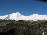
Mocho-Choshuenco
Encyclopedia

Glacier
A glacier is a large persistent body of ice that forms where the accumulation of snow exceeds its ablation over many years, often centuries. At least 0.1 km² in area and 50 m thick, but often much larger, a glacier slowly deforms and flows due to stresses induced by its weight...
covered compound stratovolcano
Stratovolcano
A stratovolcano, also known as a composite volcano, is a tall, conical volcano built up by many layers of hardened lava, tephra, pumice, and volcanic ash. Unlike shield volcanoes, stratovolcanoes are characterized by a steep profile and periodic, explosive eruptions...
in the Andes
Andes
The Andes is the world's longest continental mountain range. It is a continual range of highlands along the western coast of South America. This range is about long, about to wide , and of an average height of about .Along its length, the Andes is split into several ranges, which are separated...
of Los Ríos Region
Los Ríos Region
The XIV Los Ríos Region is one of Chile's 15 first order administrative divisions. Its capital is Valdivia. Pop. 356,396 . It began to operate as region on October 2, 2007. It was created by subdividing the Los Lagos Region in southern Chile...
, Chile
Chile
Chile ,officially the Republic of Chile , is a country in South America occupying a long, narrow coastal strip between the Andes mountains to the east and the Pacific Ocean to the west. It borders Peru to the north, Bolivia to the northeast, Argentina to the east, and the Drake Passage in the far...
. It is made of the twin volcanoes Choshuenco in the northwest and the Mocho in the southeast. The highest parts of the volcano are part of the Mocho-Choshuenco National Reserve
Mocho-Choshuenco National Reserve
The Mocho-Choshuenco National Reserve is a natural reserve around the Mocho-Choshuenco volcano, in Los Ríos Region, southern Chile. The reserve was created by decree in march 1994 and covers 7,537.6 ha distributed in Panguipulli, Los Lagos and Futrono municipality.The principal access goes from the...
while the eastern slopes are partly inside the Huilo-Huilo Natural Reserve.
Choshuenco, located on the northwest rim of the 4 km wide caldera, is of late glacial age. It has a heavily eroded crater and is currently dormant. Mocho is a andesitic-dacitic volcano placed above the caldera. Some parasitic craters and cinder cones are located on the southwest and northeast flanks of the stratovolcano. Mocho has its earliest certainly recorded eruption in 1759, older eruptions reported are uncertain due to the usage of different names and inexact maps.
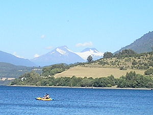
The northern foothills of Mocho-Choshuenco are surrounded by an arc of rivers and lakes formed by Fui
Fui River
Fuy River is a river in the commune of Panguipulli, southern Chile. It drains Pirihueico Lake and flows southward along the village of Neltume where it joins Neltume River and creates together Panguipulli Lake. It begins near the village of Puerto Fuy...
, Enco
Enco River
Enco River is a river in Panguipulli commune in southern Chile. By flowing from Panguipulli Lake to Riñihue Lake Enco River carries the water of the six upper lakes of the Seven Lakes area into Riñihue, the last lake in the chain...
and Llanquihue River
Llanquihue River
Llanquihue River is a river in the commune of Panguipulli, southern Chile. It is formed by the union of Neltume River and Fui River. Llanquihue River flows in a south and westward and outflows in Panguipulli Lake....
, and Pirihueico
Pirihueico Lake
Pirihueico Lake is one of Seven Lakes in Panguipullis municipality, southern Chile. The lake is of glacial origin and it is enclosed mountains of the Andes. It is located in a geological fault that includes Panguipulli Lake and Lácar Lake in Argentina. The lake is drained by Fui River. Pirihueico...
, Panguipulli
Panguipulli Lake
The Panguipulli Lake is one of the "Seven Lakes" in Panguipulli municipality, southern Chile. The lake is of glacial origin and it is enclosed by mountain ranges of the Andes, on all sides except the west, where the town of Panguipulli lies in the Chilean Central Valley. The lake is drained by the...
and Riñihue Lake
Riñihue Lake
The Riñihue Lake is a lake of glacial origin in eastern Valdivia Province, southern Chile. It is surrounded by several mountains. The eastern side receives the waters of the Panguipulli Lake, by the Enco River its main contributor. It is the last of the Seven Lakes chain. In the west is it cut...
s. The Fui River
Fui River
Fuy River is a river in the commune of Panguipulli, southern Chile. It drains Pirihueico Lake and flows southward along the village of Neltume where it joins Neltume River and creates together Panguipulli Lake. It begins near the village of Puerto Fuy...
has high degree of undergruond infiltration, such that in some years the Huilo-Huilo Falls
Huilo-Huilo Falls
The Huilo-Huilo is a waterfall located in Huilo-Huilo Biological Reserve in southern Chile. It lies next to Neltume in the international road to Huahum Pass, in the border to Argentina. The waters of the Huilo-Huilo Falls originates in Lácar Lake in Argentina. During the summer it frequently...
may dry out completely. As consequence of this infiltration a large aquifer
Aquifer
An aquifer is a wet underground layer of water-bearing permeable rock or unconsolidated materials from which groundwater can be usefully extracted using a water well. The study of water flow in aquifers and the characterization of aquifers is called hydrogeology...
is situated beneath Mocho-Choshuenco. The southern and eastern slopes drain to Pillanleufú River
Pillanleufú River
Pillanleufù River is a river in Futrono, southern Chile. It drains waters from the southern and eastern slopes of Mocho-Choshuenco volcano to Maihue Lake, which in turn flows by Calcurrupe River into Ranco Lake. The river flows in a north-south direction along the Liquiñe-Ofqui Fault....
which flows south along the Liquiñe-Ofqui Fault
Liquiñe-Ofqui Fault
The Liquiñe-Ofqui Fault is major geological fault that runs a length of roughly 1000 km in a north-south direction and exhibits current seismicity . It is located in the Chilean northern patagonean Andes. It is a dextral intra-arc transform fault...
to Maihue Lake
Maihue Lake
The Maihue Lake is a lake located east of Ranco Lake in the Andean mountains of southern Chile. The lake is of glacial origin and it is enclosed by mountain ranges of the Andes, by all sides, and drains west to Ranco Lake....
.
Name
The two volcanoes have had several historical names such as Valdivia, used by Juan Ignacio MolinaJuan Ignacio Molina
Fr. Juan Ignacio Molina was a Chilean Jesuit priest, naturalist, historian, botanist, ornithologist and geographer...
in 1795, and Panguipulli and Lajara, which Pedro Amadeo Pissis identified in 1875 as Choshuenco and Mocho respectively because only Choshuenco is visible from Panguipulli Lake
Panguipulli Lake
The Panguipulli Lake is one of the "Seven Lakes" in Panguipulli municipality, southern Chile. The lake is of glacial origin and it is enclosed by mountain ranges of the Andes, on all sides except the west, where the town of Panguipulli lies in the Chilean Central Valley. The lake is drained by the...
. Other historical spellings and names for the volcanoes include Choshuenco-Pillán
Pillan
The Pillan is a powerful and respected male spirit in Mapuche mythology....
, Rauco, Penguipulli, Reñihue and Riñihue.
The current name for the volcano is composed the by the Spanish
Spanish language
Spanish , also known as Castilian , is a Romance language in the Ibero-Romance group that evolved from several languages and dialects in central-northern Iberia around the 9th century and gradually spread with the expansion of the Kingdom of Castile into central and southern Iberia during the...
word mocho and the native Mapudungun
Mapudungun
The Mapuche language, Mapudungun is a language isolate spoken in south-central Chile and west central Argentina by the Mapuche people. It is also spelled Mapuzugun and sometimes called Mapudungu or Araucanian...
word choshuenco . Mocho means short cut and refers to the headless or edgeless shape of Mocho's volcanic cone
Volcanic cone
Volcanic cones are among the simplest volcanic formations. They are built by ejecta from a volcanic vent, piling up around the vent in the shape of a cone with a central crater. Volcanic cones are of different types, depending upon the nature and size of the fragments ejected during the eruption...
. The word choshuenco may be a corruption of the chodhuen and co which means yellow earth and water respectively. Another possible etymology is chod-hue and co which would mean place where there is water to dye yellow.
Eruptions
Very little is known about eruptions before the HoloceneHolocene
The Holocene is a geological epoch which began at the end of the Pleistocene and continues to the present. The Holocene is part of the Quaternary period. Its name comes from the Greek words and , meaning "entirely recent"...
epoch. This is explained by the great extent of the Patagonian Ice Sheet
Patagonian Ice Sheet
350px|thumb|right|Map showing the extent of the Patagonian Ice Sheet in the [[Strait of Magellan]] area during the [[last glacial period]]. Selected modern settlements are shown with yellow dots...
that covered most of the southern Andes and caught volcanic material such as ash and pyroclast. Glaciers of the ice sheet also reworked previously deposited layers.
Some 10,300 years ago Choshuenco produced the Neltume
Neltume, Chile
Neltume is a Chilean town in Panguipulli commune, of Los Ríos Region. It lies along the 203-CH route to Huahum Pass into Argentina. The town's main economic activities are forestry and, more recently, tourism since the Huilo-Huilo Biological Reserve was created in 1999...
Pumice during a plinian eruption
Plinian eruption
Plinian eruptions, also known as 'Vesuvian eruptions', are volcanic eruptions marked by their similarity to the eruption of Mount Vesuvius in AD 79 ....
.
The earliest historical accounts of eruptions from the Mocho-Choshuenco complex may be those in Alonso de Ovalle
Alonso de Ovalle
Fr. Alonso de Ovalle was a Chilean Jesuit priest and chronicler of Chilean history, author of the Historica relacion del Reyno de Chile y de las missiones y ministerios que exercita en él la Compañía de Jesus, describing the Conquest of Chile and the Arauco War.-External links:* Alonso de Ovalle,...
's map Tabula Geographica Regni Chile from 1646. Here Mocho-Choshuenco may be one of the mountains drawn as erupting volcanoes east of Valdivia
Valdivia, Chile
Valdivia is a city and commune in southern Chile administered by the Municipality of Valdivia. The city is named after its founder Pedro de Valdivia and is located at the confluence of the Calle-Calle, Valdivia and Cau-Cau Rivers, approximately east of the coastal towns of Corral and Niebla...
. In Juan Ignacio Molina
Juan Ignacio Molina
Fr. Juan Ignacio Molina was a Chilean Jesuit priest, naturalist, historian, botanist, ornithologist and geographer...
's map from 1795 Mocho-choshuenco appears erupting under the name of Volcán de Valdivia, but eruption shown in this map is probably that of 1759.
On November 1 of 1864 the Chaiquemahuida cinder cone erupted, the eruption eventually ended 1–3 days later. This explosive eruption originated from a vent on the southwestern flank of Mocho's edifice and produced pyroclastic flows. According to a missionary from Quinchilca
Quinchilca
Quinchilca is a mission located east of city of Los Lagos, Chile. Quinchilca was once one of the many missions built around Valdivia to evangelize the native Huilliches....
, who was interviewed by Vidal Gormaz in 1869, a strong noise followed by an earthquake was felt during one of the first days of November 1864.
The last reported eruption, is supposed to have occurred on June 16, 1936. Little is known about this event apart from the occurrence of mudflow
Mudflow
A mudslide is the most rapid and fluid type of downhill mass wasting. It is a rapid movement of a large mass of mud formed from loose soil and water. Similar terms are mudflow, mud stream, debris flow A mudslide is the most rapid (up to 80 km/h, or 50 mph) and fluid type of downhill mass...
s and lahar
Lahar
A lahar is a type of mudflow or debris flow composed of a slurry of pyroclastic material, rocky debris, and water. The material flows down from a volcano, typically along a river valley. The term is a shortened version of "berlahar" which originated in the Javanese language of...
s, this have led volcanologists to consider this eruption report as a false report just like in the case of the supposed 1906 Lanín
Lanín
Lanín is an ice-clad, cone-shaped stratovolcano on the border of Argentina and Chile. It forms part of two national parks: Lanín in Argentina and Villarrica in Chile. It is a symbol of the Argentine province of Neuquén, being part of its flag and its anthem. Although the date of its last eruption...
eruption.

Glaciers
The uppermost part of Mocho-Choshuenco is covered by an ice capIce cap
An ice cap is an ice mass that covers less than 50 000 km² of land area . Masses of ice covering more than 50 000 km² are termed an ice sheet....
that surrounds the volcanic cone
Volcanic cone
Volcanic cones are among the simplest volcanic formations. They are built by ejecta from a volcanic vent, piling up around the vent in the shape of a cone with a central crater. Volcanic cones are of different types, depending upon the nature and size of the fragments ejected during the eruption...
of Mocho and some flanks of Choshuenco. By 2003 the ice cap had shrunk in area by a total of 40% of its 28.4 km² (11 sq mi) area of 1976. The largest retreat by area occurred on Choshuenco Glacier at in the northwest. Mocho Glacier runs from Mocho's cone to the southeast and is the largest glacier of the volcano with its 5.1 km2 followed by Choshuenco Glaicer (2 km2).
See also
- Geology of Valdivia
- Glaciers of ChileGlaciers of ChileThe glaciers of Chile cover 2.7% of the land area of the country, excluding Antártica Chilena, and have a considerable impact on its landscape and water supply. By surface 80% of South America's glaciers lie in Chile...
- List of volcanoes in Chile