

Southern Andean Volcano Observatory
Encyclopedia
Spanish language
Spanish , also known as Castilian , is a Romance language in the Ibero-Romance group that evolved from several languages and dialects in central-northern Iberia around the 9th century and gradually spread with the expansion of the Kingdom of Castile into central and southern Iberia during the...
: Observatorio Volcanológico de los Andes del Sur), also known by its acronyms as OVDAS, is a program of the Chilean National Geology and Mining Service to watch the most dangerous volcano
Volcano
2. Bedrock3. Conduit 4. Base5. Sill6. Dike7. Layers of ash emitted by the volcano8. Flank| 9. Layers of lava emitted by the volcano10. Throat11. Parasitic cone12. Lava flow13. Vent14. Crater15...
es of the Southern Volcanic Zone in Zona Sur
Zona Sur
The Zona Sur is one of the five natural regions on which CORFO divided continental Chile in 1950. Its northern border is formed by the Bío-Bío River, the limit with the Central Chile Zone. By west with the Pacific Ocean, by the east with the Andean mountains and Argentina. Its southern border is...
and Palena
Palena, Chile
Palena is a Chilean commune located in Palena Province, Los Lagos Region. The commune is named after Palena Lake.-Demographics:According to the 2002 census of the National Statistics Institute, Palena spans an area of and has 1,690 inhabitants , making the commune an entirely rural area...
. The headquarters are at Cerro Ñielol at Temuco
Temuco
Temuco is a city and commune, capital of the Cautín Province and of the Araucanía Region in southern Chile. The name comes from the Mapudungun language, meaning "temu water"; "temu" is a tree used by Mapuches for medicinal purposes. The city is located 670 km south of Santiago...
from where there is good sight to Llaima
Llaima
Llaima Volcano is one of the largest and most active volcanoes in Chile. It is situated 82 km northeast of Temuco and 663 km southeast of Santiago, within the borders of Conguillío National Park.-Geography:...
and Villarrica
Villarrica (volcano)
Villarrica is one of Chile's most active volcanoes, rising above the lake and town of the same name. The volcano is also known as Rucapillán, a Mapuche word meaning "House of the Pillán". It is the westernmost of three large stratovolcanoes that trend perpendicular to the Andean chain along the...
, two of Chile's most active volcanoes. Much of the OVDAS work is made in collaboration with CONAF that administers the national parks and reserves where many volcanoes are located. The regional government of Araucanía Region
Araucanía Region
The IX Araucanía Region is one of Chile's 15 first order administrative divisions and comprises two provinces: Malleco in the north and Cautín in the south....
is also contributing to the project.
This is a list of the volcanoes with activity reports made by the OVDAS.
| Name | Last eruption | Regions of Chile Chile Chile ,officially the Republic of Chile , is a country in South America occupying a long, narrow coastal strip between the Andes mountains to the east and the Pacific Ocean to the west. It borders Peru to the north, Bolivia to the northeast, Argentina to the east, and the Drake Passage in the far... |
Coordinates | Geophone Geophone The term geophone derives from the Greek word "geo" meaning "earth" and "phone" meaning "sound".A geophone is a device which converts ground movement into voltage, which may be recorded at a recording station... s |
Webcams |
|---|---|---|---|---|---|
| San Pedro San Pedro (Chile volcano) San Pedro is one of the tallest active volcanoes in the world. It is located on the edge of the Atacama Desert, in Chile. San Pablo volcano is its neighbor to the east and from which is connected by a high saddle. Cerro Paniri volcano lies on the opposite side of the San Pedro River Valley. When... |
1960 | Antofagasta Antofagasta Region The II Antofagasta Region is one of Chile's fifteen first-order administrative divisions. It comprises three provinces, Antofagasta, El Loa and Tocopilla... |
21°53′S 68°24′W | 0 | 0 |
| Planchón-Peteroa Planchón-Peteroa Planchón-Peteroa is a complex volcano extending in a north-south direction along the border between Argentina and Chile. It consists of volcanoes of various ages with several overlapping calderas... |
2010 | Maule Maule Region The VII Maule Region is one of Chile's 15 first order administrative divisions. Its capital is Talca. The region takes its name from the Maule River which, running westward from the Andes, bisects the region and spans a basin of about 20,600 km2... |
35°14′24"S 70°34′12"W | 0 | 1 |
| Lonquimay Lonquimay (volcano) Lonquimay Volcano is a stratovolcano of late-Pleistocene to dominantly Holocene age, with the shape of a truncated cone. The cone is largely andesitic, though basaltic and dacitic rocks are present. It is located in the Araucanía Region of Chile, immediately SE of Tolhuaca volcano. Sierra Nevada... |
1990 | Araucanía Araucanía Region The IX Araucanía Region is one of Chile's 15 first order administrative divisions and comprises two provinces: Malleco in the north and Cautín in the south.... |
38°23′S 71°35′W | 1a | 0 |
| Llaima Llaima Llaima Volcano is one of the largest and most active volcanoes in Chile. It is situated 82 km northeast of Temuco and 663 km southeast of Santiago, within the borders of Conguillío National Park.-Geography:... |
2009 | Araucanía Araucanía Region The IX Araucanía Region is one of Chile's 15 first order administrative divisions and comprises two provinces: Malleco in the north and Cautín in the south.... |
38°41′S 71°44′W | 2 | 4 |
| Villarrica Villarrica (volcano) Villarrica is one of Chile's most active volcanoes, rising above the lake and town of the same name. The volcano is also known as Rucapillán, a Mapuche word meaning "House of the Pillán". It is the westernmost of three large stratovolcanoes that trend perpendicular to the Andean chain along the... |
2010 | Araucanía Araucanía Region The IX Araucanía Region is one of Chile's 15 first order administrative divisions and comprises two provinces: Malleco in the north and Cautín in the south.... , Los Ríos Los Ríos Region The XIV Los Ríos Region is one of Chile's 15 first order administrative divisions. Its capital is Valdivia. Pop. 356,396 . It began to operate as region on October 2, 2007. It was created by subdividing the Los Lagos Region in southern Chile... |
39.42°S 71.93°W | 2 | 4 |
| Mocho-Choshuenco Mocho-Choshuenco Mocho-Choshuenco is a glacier covered compound stratovolcano in the Andes of Los Ríos Region, Chile. It is made of the twin volcanoes Choshuenco in the northwest and the Mocho in the southeast... |
1864 | Los Ríos Los Ríos Region The XIV Los Ríos Region is one of Chile's 15 first order administrative divisions. Its capital is Valdivia. Pop. 356,396 . It began to operate as region on October 2, 2007. It was created by subdividing the Los Lagos Region in southern Chile... |
39°55′S 72°02′W | 1 | 0 |
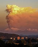
| Cordón Caulle | 2011 | Los Ríos Los Ríos Region The XIV Los Ríos Region is one of Chile's 15 first order administrative divisions. Its capital is Valdivia. Pop. 356,396 . It began to operate as region on October 2, 2007. It was created by subdividing the Los Lagos Region in southern Chile... , Los Lagos Los Lagos Region Los Lagos Region is one of Chile's 15 regions, which are first order administrative divisions, and comprises four provinces: Chiloé, Llanquihue, Osorno and Palena. The region contains the country's second largest island, Chiloé, and the second largest lake, Llanquihue.Its capital is Puerto Montt;... |
40°31′S 72°12′W | 0 | 0 |
| Osorno | 1869 | Los Lagos Los Lagos Region Los Lagos Region is one of Chile's 15 regions, which are first order administrative divisions, and comprises four provinces: Chiloé, Llanquihue, Osorno and Palena. The region contains the country's second largest island, Chiloé, and the second largest lake, Llanquihue.Its capital is Puerto Montt;... |
41°06′S 72°30′W | 1 | 0 |
| Calbuco | 1972 | Los Lagos Los Lagos Region Los Lagos Region is one of Chile's 15 regions, which are first order administrative divisions, and comprises four provinces: Chiloé, Llanquihue, Osorno and Palena. The region contains the country's second largest island, Chiloé, and the second largest lake, Llanquihue.Its capital is Puerto Montt;... |
41.32°S 72.60°W | 1 | 0 |
| Chaitén Chaitén (volcano) |290px|thumb|right|Image of the [[rhyolitic]] [[lava dome]] of Chaitén Volcano during its 2008-2010 eruption.Chaitén is a volcanic caldera in diameter, west of the elongated ice-capped Michinmahuida volcano and northeast of the town of Chaitén, near the Gulf of Corcovado in southern Chile. The... |
2010 | Los Lagos Los Lagos Region Los Lagos Region is one of Chile's 15 regions, which are first order administrative divisions, and comprises four provinces: Chiloé, Llanquihue, Osorno and Palena. The region contains the country's second largest island, Chiloé, and the second largest lake, Llanquihue.Its capital is Puerto Montt;... |
42°50′S 72°39′W | 0 | 2 |
| Melimoyu Melimoyu Melimoyu is a stratovolcano with an 8-km-wide, largely buried caldera located about 40 km NW of the town of Puerto Puyuhuapi, in the Aisén Region of Chile. It lies near the northern entrance of the Moraleda Channel.- References :*... |
200 AD ± 75 years | Aysén Aysen Region The XI Aisén Region of General Carlos Ibáñez del Campo , also spelled Aysén, is one of Chile's 15 first order administrative divisions. Although the third largest in area, the region is Chile's most sparsely populated region with a population of 105,000. The capital of the region is Coihaique, the... |
44°05′0"S 72°53′0"W | 0 | 0 |
- a- not connected to the telephone networkTelephone networkA telephone network is a telecommunications network used for telephone calls between two or more parties.There are a number of different types of telephone network:...