
Red Hill Valley Parkway
Encyclopedia

Canada
Canada is a North American country consisting of ten provinces and three territories. Located in the northern part of the continent, it extends from the Atlantic Ocean in the east to the Pacific Ocean in the west, and northward into the Arctic Ocean...
city of Hamilton, Ontario
Hamilton, Ontario
Hamilton is a port city in the Canadian province of Ontario. Conceived by George Hamilton when he purchased the Durand farm shortly after the War of 1812, Hamilton has become the centre of a densely populated and industrialized region at the west end of Lake Ontario known as the Golden Horseshoe...
. The route connects the Lincoln M. Alexander Parkway
Lincoln M. Alexander Parkway
The Lincoln Alexander Parkway, officially nicknamed "The Linc", is a municipal expressway in the Canadian city of Hamilton, Ontario. Located on the Hamilton mountain, atop the Niagara Escarpment...
, Hamilton's second municipal expressway, to the Queen Elizabeth Way
Queen Elizabeth Way
The Queen Elizabeth Way, commonly abbreviated as the QEW, is a 400-Series highway in the Canadian province of Ontario. The freeway links Buffalo, New York and the Niagara Peninsula with Toronto. It begins at the Peace Bridge in Fort Erie and travels around the western shore of Lake Ontario, ending...
(QEW) near Hamilton Harbour. It is named after Red Hill Valley
Red Hill Valley
Red Hill Valley is a valley in eastern and south-eastern Hamilton, Ontario, Canada. The valley is named after and home to the Red Hill Creek, which flows from south-east to north-west, from the Niagara Escarpment to Hamilton harbour, a distance of . The name of the area comes from the reddish soil,...
, through which it descends the Niagara Escarpment
Niagara Escarpment
The Niagara Escarpment is a long escarpment, or cuesta, in the United States and Canada that runs westward from New York State, through Ontario, Michigan, Wisconsin and Illinois...
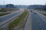
. It is a 7 kilometres (4.3 mi) four-lane freeway with a speed limit of 90 kilometres per hour (55.9 mph).
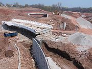
The $245 million expressway was built through the Red Hill Valley by the City of Hamilton after a decades-long battle with opponents. The expressway was first proposed in the 1950s and was cancelled and resurrected several times. Last-ditch efforts by opponents, including occupying the valley, law suits and blocking construction access, failed and the expressway was finally constructed in the 2000s, opening to traffic in 2007. The cost to the city included $100 million in construction costs, plus legal costs fighting to get the expressway constructed. The city fought the provincial government once and the federal government twice to build the project. As of November 2009, a $75 million law suit is still pending with the federal government.
Route description
The expressway starts at the Queen Elizabeth Way. Proceeding southbound, the Creek and a stormwater pond can be seen on the right. From the QEW interchange to Barton Street, the expressway crosses over the Creek several times with industrial lands to the south (left) and industrial lands on the right as far as the CNRCanadian National Railway
The Canadian National Railway Company is a Canadian Class I railway headquartered in Montreal, Quebec. CN's slogan is "North America's Railroad"....
rail lines. This area's trees were removed from this area as part of the project; there are some remaining trees on both sides of the expressway at Barton Street.
This section, which is not far above the water level of Lake Ontario
Lake Ontario
Lake Ontario is one of the five Great Lakes of North America. It is bounded on the north and southwest by the Canadian province of Ontario, and on the south by the American state of New York. Ontario, Canada's most populous province, was named for the lake. In the Wyandot language, ontarío means...
, is prone to flooding. On July 26, 2009, sections of the expressway at the QEW were closed due to flooding of the Red Hill Creek after a thunderstorm. On July 7, 2010, sections of the expressway at Barton Street were closed due to flooding of the Red Hill Creek after a thunderstorm.
From Barton Street, the expressway travels along the Creek, which is visible on the right. Both sides of the highway are residential lands, and the slopes of the valley have some forestation as far south as Queenston, where the valley sides were cleared of trees and landscaped for the interchange, with sound barriers on the top of the slopes. South of Queenston Road, the expressway passes through a forested part of the valley, and the road cut through the trees is narrower, as far south as King Street, where the valley was cleared and landscaped for the interchange, King Street and Mount Albion Streets.
South of King Street, the Creek is visible on the west side, as far south as the rail lines. Past the CPR
Canadian Pacific Railway
The Canadian Pacific Railway , formerly also known as CP Rail between 1968 and 1996, is a historic Canadian Class I railway founded in 1881 and now operated by Canadian Pacific Railway Limited, which began operations as legal owner in a corporate restructuring in 2001...
rail lines, the Creek diverges west into Rosedale Park, while the expressway hugs the east side of the valley. On the east side of the valley at this point is Red Hill and the Red Hill residential area is isolated from the expressway by a noise barrier.
Greenhill Avenue, from the east, was extended to the expressway. The area of the Greenhill interchange was a forested part of the valley, and is now a grassy area around the expressway and interchange. South of Greenhill, the expressway enters King's Forest park. The expressway stays along the east side of the valley, while on the west side is the King's Forest Golf Course. The expressway ascends the Niagara Escarpment along a viaduct, through a rock cut, to where it intersects and continues as the Lincoln Alexander to the west.
From the QEW to Greenhill Avenue, the highway is two lanes in either direction. From Greenhill to the Lincoln Alexander, the highway is three lanes southbound and two lanes northbound. The northbound and southbound lanes are separated by guard-rails and a grass median.
History
The expressway was first proposed in the 1950s. Hamilton first voted to put a highway through the valley in 1954. A consultancy hired by the City of Hamilton produced a plan to build an expressway within the valley in 1956. Construction was not approved, and the plan to build an expressway was not revisited until 1963, when Hamilton City Council approved the 'Hamilton Area Transportation Study' which includes the Red Hill Expressway as one of five proposed expressways. The RHVP is added to the City's Official Plan. Opposition to the project developed during the 1960s and early 1970s. In 1974, the expressway is removed from the City and Regional Government's Official Plans.The RHVP project did not remain dead for long. City Council voted three further times against the project before voting in favour of a Red Hill Valley route in 1977. The City of Hamilton was planning an East-West Expressway in lower Hamilton, which required a subsidy from the provincial government. The provincial government refused to pay the subsidy without the City proposing to build the Red Hill.
A plan for the expressway was approved by Regional Council in 1979. The project required approvals from various boards: the Ontario Municipal Board (OMB), Ontario Environmental Assessment Board (OEAB), Niagara Escarpment Commission
Niagara Escarpment Commission
The Niagara Escarpment Commission, founded in June 1973 by the Niagara Escarpment Planning and Development Act, is an agency of the Ontario government. Its mission is to "conserve the UNESCO-designated Niagara Escarpment World Biosphere Reserve as a continuous natural environment and scenic,...
(NEC) and the Hamilton Region Conservation Authority (HRCA). The provincial government decided to submit approval for the project to one, larger hearing process, called the 'Consolidated Joint Board' which had two OMB officials and one OEAB official. 99 days of hearing were held in 1984. The OEAB, NEC and HRCA all opposed the project. Against the wishes of those agencies, and a group called "Save the Valley", the Board approved the project 2-1, with the OEAB representative dissenting, in October 1985.
The Save the Valley organization and the HRCA appealed to the provincial government, hoping for a cancellation like the Spadina Expressway
Spadina Expressway
The Spadina Expressway was a proposed north-south freeway in Toronto, Ontario, Canada. It was only partially built before being cancelled in 1971 due to public opposition. It was proposed in the mid-1960s as part of a network of freeways for Metropolitan Toronto. Its cancellation prompted the...
in Toronto, but the appeal was rejected in 1987. Construction began in 1990, but was stopped by the election of the Ontario New Democratic Party
Ontario New Democratic Party
The Ontario New Democratic Party or , formally known as New Democratic Party of Ontario, is a social democratic political party in Ontario, Canada. It is a provincial section of the federal New Democratic Party. It was formed in October 1961, a few months after the federal party. The ONDP had its...
(NDP) government of Bob Rae
Bob Rae
Robert Keith "Bob" Rae, PC, OC, OOnt, QC, MP is a Canadian politician. He is the Member of Parliament for Toronto Centre and interim leader of the Liberal Party of Canada....
. NDP MPPs had won all six ridings in the Hamilton area and had opposed the project as a matter of party policy. The Rae government withdrew funding for the project. Construction on both the King Street East and Queenston Road replacement bridges had already been completed.
Hamilton-Wentworth Regional Council started a legal action in 1991 to get the funding reinstated, but was unsuccessful. Former Toronto mayor David Crombie was appointed by the Rae government to mediate the dispute. Crombie produced a plan without an expressway, instead proposing the construction and expansion of arterial roads on either side of the valley. The compromise was rejected by Regional Council in 1994. In 1995, the Mike Harris
Mike Harris
Michael Deane "Mike" Harris was the 22nd Premier of Ontario from June 26, 1995 to April 15, 2002. He is most noted for the "Common Sense Revolution", his Progressive Conservative government's program of deficit reduction in combination with lower taxes and cuts to government...
Progressive Conservatives
Progressive Conservative Party of Canada
The Progressive Conservative Party of Canada was a Canadian political party with a centre-right stance on economic issues and, after the 1970s, a centrist stance on social issues....
won the provincial election. The Harris government restored funding to the RHVP project.
While the project was again funded, it still required environment approvals to continue. Norm Sterling
Norm Sterling
Norman William Sterling is a politician in Ontario, Canada. He is one of the longest-serving members of the Legislative Assembly of Ontario, having been first elected in 1977....
, Ontario Minister of the Environment, exempted the project. The Government of Canada notified Hamilton that the project would require federal environment approval, which Hamilton applied for in 1998. Environment Canada initiated a full environmental review, which Hamilton opposed, launching a lawsuit, arguing that the project had already been approved. A federal judicial review board sided with Hamilton, clearing the project for construction, although the federal government appealed twice to overturn the verdict. After losing the second appeal in 2001, the federal government decided not to appeal the judgment to the Supreme Court.
The City of Hamilton then launched a $75 million lawsuit against the Government of Canada, alleging misconduct in delaying the project. The lawsuit named federal cabinet ministers David Anderson
David Anderson
David A. Anderson, is a former Canadian cabinet minister.Educated at Victoria College in Victoria, BC and the University of British Columbia, Anderson served as a foreign service officer in the Department of External Affairs between 1962 and 1968...
, Sheila Copps
Sheila Copps
Sheila Maureen Copps, PC is a former Canadian politician who also served as Deputy Prime Minister of Canada from November 4, 1993 to April 30, 1996 and June 19, 1996 to June 11, 1997....
, Herb Dhaliwal
Herb Dhaliwal
Harbance Singh Dhaliwal, PC is a Canadian politician.Born to a Sikh family in Punjab, India, Dhaliwal's family immigrated to Vancouver when he was six. He attended John Oliver Secondary School, graduating in 1972...
and Christine Stewart
Christine Stewart
Christine Susan Stewart, PC is a former Canadian politician. A Liberal Party Member of Parliament for the riding of Northumberland, she was first elected to the Canadian House of Commons as an Opposition member by a margin of 27 votes in 1988...
, as well as 65 federal employees as defendants. The lawsuit alleged "the defendants abused their public office by engaging in targeted malice towards the City's completion of the Expressway" and utilized environmental assessment "in an unprecedented, illegal and unconstitutional manner in order to achieve that objective." In 2008, after rejecting an offer to settle by the Government of Canada, Hamilton Council voted 8–6 to continue the lawsuit and remove a $450,000 spending cap on the suit. In November 2009, Hamilton Council voted to continue the lawsuit, and defeated a motion to make the legal costs public.
Opponents criticized the expected environmental damage of the project and questioned the economic viability of highway building in the face of declining oil production. Opponents asserted that two groups would be the chief beneficiaries of the expressway: long-distance truckers travelling from Detroit to Buffalo, and land developers on the Hamilton Mountain
Hamilton Mountain
Hamilton Mountain is a federal electoral district in Ontario, Canada, that has been represented in the Canadian House of Commons since 1968. The riding is located in the Hamilton, Ontario region....
. Opponents also took issue with the city spending $220 million (its share of the project) to build the expressway. Opponents also argued that the need for the expressway was not shown in studies. A 1963 transportation study which supported construction, expected the population of Hamilton to be 785,000 by 1985, while the actual population reached 480,000 by 2001. Employment in the industrial bayfront had dropped and a commuting route between Hamilton Mountain and the bayfront was less necessary.
Proponents also asserted that, despite the introduction of the expressway, care would be taken to ensure that the Red Hill Valley would be preserved and environmentally improved from its current situation. Hamilton removed a toxic landfill leaking into the Creek, and made stream naturalization part of the construction project plan. Hamilton also made plans to replace park lands lost and plant trees to replace those lost to the expressway.
When Hamilton began construction of the expressway project, opponents began physically obstructing the construction of the project. Access roads were blocked, trees in the path of the roadway were occupied. Members of the Friends of the Red Hill Valley and Six Nations Confederacy camped out in the valley. Construction was halted while Hamilton fought a legal action launched by the Six Nations. Hamilton proceeded with legal action against the other occupiers. Eventually, the Six Nations entered into a partnership with Hamilton to manage the remaining green space. A Hamilton municipal election was held in 2003, with pro-Expressway candidate Larry Di Ianni winning the mayorship over Expressway opponent David Christopherson. Construction restarted in earnest with grading contracts in 2004. The squatters were removed and full-time security guards patrolled the site during construction.
The expressway unofficially opened on November 3, 2007. The opening was accompanied by the Road to Hope race run by 150 people. The parkway was originally scheduled to be officially opened to vehicular traffic on November 16, 2007 but the date was postponed to November 17, 2007. The final estimate of construction cost was $245 million for the 7 kilometres (4.3 mi) long expressway. $120 million of the cost was paid for by the provincial government.
Exit list
{| class="wikitable"|-
! km
Kilometre
The kilometre is a unit of length in the metric system, equal to one thousand metres and is therefore exactly equal to the distance travelled by light in free space in of a second...
! Destinations
! Additional Notes
|-
|colspan="3" style="text-align:center;"|Red Hill Valley Parkway continues west as Lincoln M. Alexander Parkway
Lincoln M. Alexander Parkway
The Lincoln Alexander Parkway, officially nicknamed "The Linc", is a municipal expressway in the Canadian city of Hamilton, Ontario. Located on the Hamilton mountain, atop the Niagara Escarpment...
|-
| 6
| – Albion Falls, Jerome
|
|-
| 5
| Greenhill Avenue – Vincent, Red Hill
| Greenhill Avenue ends upon the interchange with Red Hill Valley Parkway.
|-
| 4
| King Street / Lawrence Road – Gershome, Vincent, Landsdale, Central
|
|-
| 3
| – Glenview, Blakeley, The Delta, Stoney Creek
Stoney Creek, Ontario
Stoney Creek is a community in Ontario, Canada.Note: This article will only deal with matters up to its amalgamation with Hamilton.-Geography and population:...
, Fruitland
Fruitland, Ontario
Fruitland, Ontario is a community in the western end of Hamilton, Ontario. Its adjacent community includes Beamsville, and Grimsby. The region became known as Fruitland due to its fertile soil, and the region is renowned for its winery industry. At the Eastern border is Fifty Road and its...
|
|-
| 1
| Barton Street
Barton Street (Hamilton, Ontario)
Barton Street is an arterial road in the Lower City of Hamilton, Ontario, Canada. It's also the longest street in the city. It starts off at the Western end of town at Locke Street North and is a two-way street that stretches eastward through a number of different and varied communities in the...
– Nashdale, Crown Point, Stipeley, Central
|
|-
| 0
|
| Northern terminus