
New York State Route 426
Encyclopedia
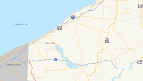
New York State Route 426 (NY 426) is a state highway
located entirely within Chautauqua County
, New York
, United States
. It runs just over 13 miles (21 km) from one section of the Pennsylvania state line to another, passing through two small hamlets and providing the Southern Tier Expressway (NY 17
and Interstate 86 or I-86) with its westernmost exit in New York. NY 426 is the westernmost north–south state highway in New York.
At both crossings of the state line it continues as Pennsylvania Route 426. It is the only other state highway besides NY 440
that can claim the distinction of being a middle segment of another state's similarly-numbered highway. The New York alignment has remained virtually unchanged since it was assigned as part of the 1930 renumbering of state highways in New York, while the designations of the roads it connects to in Pennsylvania have varied over the years. The two segments of PA 426 were established at different times in the 1940s.
leaves off at the Pennsylvania state line in French Creek
6 miles (10 km) north of Corry, Pennsylvania
. The route heads north through rural southwestern Chautauqua County
to the small community known as Cutting, where it overlaps NY 474
for a tenth of a mile (0.16 km) westward before resuming its trek northward. Roughly 1.5 miles (2.4 km) north of Cutting, NY 426 veers to the west to avoid a large ridge situated near Beaver Meadow Brook, a small stream leading to French Creek
. The route follows the brook to where it converges with the creek, then parallels French Creek northward toward the waterside hamlet of French Creek. The creek and NY 426 split south of the community, with the creek continuing along French Creek – Mina Road to the hamlet while NY 426 bypasses French Creek to the west. The route enters the town of Mina
upon intersecting Harrington Hill Road a mile (1.6 km) to the north.
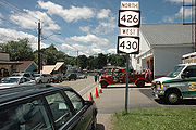
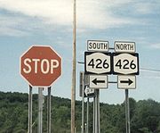 A half mile (0.8 km) into Mina, NY 426 comes within view of Findley Lake, a body of water 2 miles (3.2 km) long from south to north and as wide as one-half mile (0.8 km) at points. The route follows the eastern edge of the lake north to the hamlet of Findley Lake, situated at the northern tip of the lake. Here, NY 426 overlaps NY 430
westward for three blocks through the community prior to connecting to the Southern Tier Expressway (I-86
and NY 17
) by way of an interchange 1 miles (1.6 km) north of Findley Lake. The exit is the westernmost exit on NY 17; however, the expressway itself continues west to I-90 near Erie, Pennsylvania
, as I-86. Past the expressway, NY 426 continues northwest for another 2 miles (3.2 km) through nondescript terrain to the Pennsylvania state line, where it becomes the northern segment of PA 426.
 The entirety of NY 426 was assigned as part of the 1930 renumbering of state highways in New York as a northward extension of Pennsylvania Route 189, a short route leading south to Corry, Pennsylvania
. Originally, NY 426 broke from its modern alignment at French Creek – Mina Road to serve the hamlet of French Creek via French Creek – Mina and King Roads before rejoining its current route west of the hamlet. The route was realigned onto its present alignment west of French Creek ca. 1936. In the early 1940s, the 426 designation was extended southward into Pennsylvania
as Pennsylvania Route 426. It was also extended northwestward into Pennsylvania in the mid-1940s, effectively making NY 426 the missing segment of an otherwise discontinuous PA 426.
State highway
State highway, state road or state route can refer to one of three related concepts, two of them related to a state or provincial government in a country that is divided into states or provinces :#A...
located entirely within Chautauqua County
Chautauqua County, New York
-Major highways:* Interstate 86/New York State Route 17 * Interstate 90 * U.S. Route 20* U.S. Route 62* New York State Route 5* New York State Route 39* New York State Route 60* New York State Route 394...
, New York
New York
New York is a state in the Northeastern region of the United States. It is the nation's third most populous state. New York is bordered by New Jersey and Pennsylvania to the south, and by Connecticut, Massachusetts and Vermont to the east...
, United States
United States
The United States of America is a federal constitutional republic comprising fifty states and a federal district...
. It runs just over 13 miles (21 km) from one section of the Pennsylvania state line to another, passing through two small hamlets and providing the Southern Tier Expressway (NY 17
New York State Route 17
New York State Route 17 is a state highway that extends for through the Southern Tier and Downstate regions of New York in the United States...
and Interstate 86 or I-86) with its westernmost exit in New York. NY 426 is the westernmost north–south state highway in New York.
At both crossings of the state line it continues as Pennsylvania Route 426. It is the only other state highway besides NY 440
New York State Route 440
New York State Route 440 is a state highway located entirely on Staten Island in New York City. The route acts as a connector between the two segments of New Jersey Route 440, running from the Staten Island community of Richmond Valley to the south to Port Richmond to the north...
that can claim the distinction of being a middle segment of another state's similarly-numbered highway. The New York alignment has remained virtually unchanged since it was assigned as part of the 1930 renumbering of state highways in New York, while the designations of the roads it connects to in Pennsylvania have varied over the years. The two segments of PA 426 were established at different times in the 1940s.
Route description
NY 426 begins where the southern segment of Pennsylvania Route 426Pennsylvania Route 426
Pennsylvania Route 426 is a long state highway in Warren and Erie counties of Pennsylvania. The route is split up into two segments, connected by New York State Route 426 through New York....
leaves off at the Pennsylvania state line in French Creek
French Creek, New York
French Creek is a town in Chautauqua County, New York, United States. The population was 935 at the 2000 census. The town is named after the stream flowing through it.The Town of French Creek lies in the southwest corner of Chautauqua County....
6 miles (10 km) north of Corry, Pennsylvania
Corry, Pennsylvania
Corry is a city located in northwestern Pennsylvania in the United States. With a population of 6,834 at the 2000 United States Census, it is the second largest city in Erie County. Corry is a part of the Erie Metropolitan Statistical Area...
. The route heads north through rural southwestern Chautauqua County
Chautauqua County, New York
-Major highways:* Interstate 86/New York State Route 17 * Interstate 90 * U.S. Route 20* U.S. Route 62* New York State Route 5* New York State Route 39* New York State Route 60* New York State Route 394...
to the small community known as Cutting, where it overlaps NY 474
New York State Route 474
New York State Route 474 is a state highway located entirely in Chautauqua County, in the westernmost corner of New York in the United States...
for a tenth of a mile (0.16 km) westward before resuming its trek northward. Roughly 1.5 miles (2.4 km) north of Cutting, NY 426 veers to the west to avoid a large ridge situated near Beaver Meadow Brook, a small stream leading to French Creek
French Creek (Allegheny River)
French Creek is a tributary of the Allegheny River in northwestern Pennsylvania and western New York in the United States.- Etymology :...
. The route follows the brook to where it converges with the creek, then parallels French Creek northward toward the waterside hamlet of French Creek. The creek and NY 426 split south of the community, with the creek continuing along French Creek – Mina Road to the hamlet while NY 426 bypasses French Creek to the west. The route enters the town of Mina
Mina, New York
Mina is a town in Chautauqua County, New York, USA. The population was 1,176 at the 2000 census.The Town of Mina is at the western county border. The town is best known as a summer resort area...
upon intersecting Harrington Hill Road a mile (1.6 km) to the north.
New York State Route 430
New York State Route 430 is a state highway located entirely within Chautauqua County, New York, in the United States. Its western terminus is located at the Pennsylvania state line near the hamlet of Findley Lake in the town of Mina. The eastern terminus is located in the city of Jamestown...
westward for three blocks through the community prior to connecting to the Southern Tier Expressway (I-86
Interstate 86 (east)
Interstate 86 is an Interstate Highway that extends for through northwestern Pennsylvania and southern New York in the United States...
and NY 17
New York State Route 17
New York State Route 17 is a state highway that extends for through the Southern Tier and Downstate regions of New York in the United States...
) by way of an interchange 1 miles (1.6 km) north of Findley Lake. The exit is the westernmost exit on NY 17; however, the expressway itself continues west to I-90 near Erie, Pennsylvania
Erie, Pennsylvania
Erie is a city located in northwestern Pennsylvania in the United States. Named for the lake and the Native American tribe that resided along its southern shore, Erie is the state's fourth-largest city , with a population of 102,000...
, as I-86. Past the expressway, NY 426 continues northwest for another 2 miles (3.2 km) through nondescript terrain to the Pennsylvania state line, where it becomes the northern segment of PA 426.
History
Corry, Pennsylvania
Corry is a city located in northwestern Pennsylvania in the United States. With a population of 6,834 at the 2000 United States Census, it is the second largest city in Erie County. Corry is a part of the Erie Metropolitan Statistical Area...
. Originally, NY 426 broke from its modern alignment at French Creek – Mina Road to serve the hamlet of French Creek via French Creek – Mina and King Roads before rejoining its current route west of the hamlet. The route was realigned onto its present alignment west of French Creek ca. 1936. In the early 1940s, the 426 designation was extended southward into Pennsylvania
Pennsylvania
The Commonwealth of Pennsylvania is a U.S. state that is located in the Northeastern and Mid-Atlantic regions of the United States. The state borders Delaware and Maryland to the south, West Virginia to the southwest, Ohio to the west, New York and Ontario, Canada, to the north, and New Jersey to...
as Pennsylvania Route 426. It was also extended northwestward into Pennsylvania in the mid-1940s, effectively making NY 426 the missing segment of an otherwise discontinuous PA 426.