

New York State Route 430
Encyclopedia
New York State Route 430 (NY 430) is a state highway
located entirely within Chautauqua County, New York
, in the United States. Its western terminus is located at the Pennsylvania
state line near the hamlet of Findley Lake in the town of Mina
. The eastern terminus is located in the city of Jamestown
at a junction with NY 60
(North Main Street). NY 430 is ceremoniously designated as the Senator Jess J. Present Memorial Highway in honor of Jess Present
, a New York State Senator from Jamestown.
Municipalities NY 430 runs through include (from west to east) the villages of Sherman
and Mayville
, the hamlet of Maple Springs
, the village of Bemus Point
and the city of Jamestown. Besides NY 60, NY 430 intersects with NY 76
in Sherman and NY 394
in Mayville. It meets the Southern Tier Expressway (Interstate 86
or I-86 and NY 17
) multiple times: in Sherman via NY 76, twice in Bemus Point (once by way of a short expressway designated as the unsigned NY 954J and also via an interchange located southwest of NY 954J), and in Jamestown via Strunk Road. NY 430 also runs along the east side of Chautauqua Lake
, and services both Long Point State Park
and Midway Park
.
The portion of NY 430 east of Mayville was originally designated as part of NY 17 in 1924; the remainder was originally designated as New York State Route 75 as part of the 1930 renumbering of state highways in New York. NY 75 was renumbered to NY 430 ca. 1932. NY 430 was extended eastward to its current terminus in Jamestown in the late 1970s after NY 17 was realigned onto a newly completed section of the Southern Tier Expressway between Bemus Point and Jamestown.
 West of Mayville
, NY 430 is a largely rural route connecting Erie, Pennsylvania
, (via Pennsylvania Route 430 or PA 430) to Mayville via Sherman
; however, east of Mayville, the route is a primary arterial serving the northern and eastern shores of Chautauqua Lake
.
state line in rural western Chautauqua County
as a continuation of PA 430, which begins roughly 13 miles (21 km) to the west in Erie
. The route proceeds eastward as a county-maintained, state-numbered highway through the westernmost portion of the town of Mina
to the hamlet of Findley Lake, a small community located at the northern tip of the lake of the same name. Here, the New York State Department of Transportation
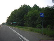
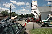
assumes maintenance of the route at a junction with NY 426
. NY 430 briefly overlaps with NY 426 through the community and past the northern tip of the waterbody that gives the hamlet its name. The two routes split at the eastern edge of the community.
While NY 426 leaves NY 430 to follow the eastern edge of the lake southward toward French Creek
, NY 430 continues to the northeast, passing through the hamlet of Mina and over the Southern Tier Expressway (I-86
and NY 17
) on its way to the town of Sherman
and the village of the same name
. Within the village of Sherman, NY 430 becomes Main Street and intersects NY 76
west of the village center. The two routes overlap for a single block before separating at the heart of the village, with NY 76 continuing southward to an interchange with the Southern Tier Expressway just outside of the village and, farther south, to its southern terminus at NY 474
in Clymer
. NY 430, however, exits Sherman to the east before turning northward to parallel an old railroad bed northward into the town of Chautauqua
.
 At the hamlet of Summerdale, NY 430 curves to the northeast, generally following the former rail line into Mayville
, a village situated at the northwestern tip of Chautauqua Lake
. In the center of the village, NY 430 intersects NY 394
at an intersection that once was the eastern terminus of NY 430. Now, however, NY 430 continues northeast past NY 394 and out of Mayville.
 East of Mayville, NY 430 parallels the northern and eastern shoreline of Chautauqua Lake, providing access to several lakeside residences and communities along the route. Roughly halfway down the length of the lake in Ellery
, NY 430 passes both Midway State Park, a local amusement park
, and Long Point State Park
. South of Long Point, NY 430, a two-lane undivided roadway up to this point, becomes a limited-access highway as it approaches Bemus Point
. NY 430 exits from the road soon after while the expressway heads south as NY 954J for another 1.62 miles (2.61 km) to exit 10 on the Southern Tier Expressway.
NY 430, once more a surface road, becomes county-maintained again as it heads southwest on Lakeside Drive to Bemus Point, a village located at the narrowest point of Chautauqua Lake between Mayville and Jamestown
. Due to the narrow width of the lake at Bemus Point, a ferry
once ran from the end of Lakeside Drive to the Harmony
hamlet of Stow; however, it has since been replaced with the Chautauqua Lake Bridge on the Southern Tier Expressway farther south. NY 430, however, turns southeast at Main Street and connects to the aforementioned expressway at the eastern end of the Chautauqua Lake Bridge by way of an interchange near the southern edge of Bemus Point.
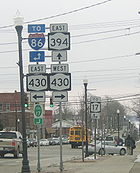
Past the exit, NY 430 becomes state-maintained again as it parallels both the Southern Tier Expressway and Chautauqua Lake to Jamestown, where NY 430 meets I-86 and NY 17 one final time at exit 11 (via Strunk Road). Within the city, state maintenance of NY 430 ends for good at Washington Street, and NY 430 continues east as a city street for roughly four blocks before ending at an intersection with NY 60
(North Main Street) north of downtown.
were assigned in 1924, what is now NY 430 between Mayville
and Jamestown
was designated as part of NY 17
. In the 1930 renumbering of state highways in New York, this section of NY 17 was left unchanged while a previously unnumbered roadway leading from NY 17 in Mayville to Findley Lake via Sherman
was designated as NY 75. When U.S. Route 62
(US 62) was extended into New York ca. 1932, NY 75 was reassigned to what had been designated as NY 62 as part of the 1930 renumbering. The original NY 75 was renumbered to NY 430.
NY 430 remained unchanged until the late 1950s when the route was extended westward to the Pennsylvania
state line to connect to the new Pennsylvania Route 430, an east–west highway leading to Erie
. In the late 1970s, NY 17 was rerouted onto the new Southern Tier Expressway (STE) from Bemus Point
to Jamestown
. Its former at-grade alignment between the two locations became an eastward extension of NY 430. At the time, the portion of the STE between Sherman
and Bemus Point was under construction, resulting in a temporary overlap between NY 17 and NY 430 from Mayville to modern NY 954J. Work began ca. 1981 on the segment of the STE between Findley Lake and Sherman. The entirety of the Findley Lake – Bemus Point section of the expressway was completed by 1985 as a realignment of NY 17. In 2005, the entirety of NY 430 was ceremoniously designated as the "Senator Jess J. Present Memorial Highway" in honor of Jess Present
, a New York State Senator from Jamestown.
State highway
State highway, state road or state route can refer to one of three related concepts, two of them related to a state or provincial government in a country that is divided into states or provinces :#A...
located entirely within Chautauqua County, New York
Chautauqua County, New York
-Major highways:* Interstate 86/New York State Route 17 * Interstate 90 * U.S. Route 20* U.S. Route 62* New York State Route 5* New York State Route 39* New York State Route 60* New York State Route 394...
, in the United States. Its western terminus is located at the Pennsylvania
Pennsylvania
The Commonwealth of Pennsylvania is a U.S. state that is located in the Northeastern and Mid-Atlantic regions of the United States. The state borders Delaware and Maryland to the south, West Virginia to the southwest, Ohio to the west, New York and Ontario, Canada, to the north, and New Jersey to...
state line near the hamlet of Findley Lake in the town of Mina
Mina, New York
Mina is a town in Chautauqua County, New York, USA. The population was 1,176 at the 2000 census.The Town of Mina is at the western county border. The town is best known as a summer resort area...
. The eastern terminus is located in the city of Jamestown
Jamestown, New York
Jamestown is a city in Chautauqua County, New York in the United States. The population was 31,146 at the 2010 census.The City of Jamestown is adjacent to Town of Ellicott and is at the southern tip of Chautauqua Lake...
at a junction with NY 60
New York State Route 60
New York State Route 60 is a north–south state highway in Chautauqua County, New York, United States. The southern terminus of the route is at an intersection with U.S. Route 62 south of the city of Jamestown in the town of Kiantone. Its northern terminus is at a junction with NY 5...
(North Main Street). NY 430 is ceremoniously designated as the Senator Jess J. Present Memorial Highway in honor of Jess Present
Jess Present
Jess J. Present was a New York State Senator from Jamestown, New York.He joined the New York State Assembly in 1966 but only stayed two terms, moving to the New York State Senate in 1968 after James F. Hastings left for the U.S...
, a New York State Senator from Jamestown.
Municipalities NY 430 runs through include (from west to east) the villages of Sherman
Sherman (village), New York
Sherman is a village in the town of Sherman, Chautauqua County, New York, USA. The village lies in the northern part of the town at intersections of Routes 15, 18, NY-76 and NY-430. The population was 714 at the 2000 census.- History :...
and Mayville
Mayville, New York
-Demographics:As of the census of 2000, there were 1,756 people, 686 households, and 399 families residing in the village. The population density was 875.0 people per square mile . There were 860 housing units at an average density of 428.5 per square mile...
, the hamlet of Maple Springs
Maple Springs, New York
Maple Springs is a hamlet located within the Town of Ellery in Chautauqua County, New York in the United States at an elevation of 1312 ft above sea level. It is situated along the east shore of Chautauqua Lake, between the villages of Mayville and Bemus Point. The postal code is 14756...
, the village of Bemus Point
Bemus Point, New York
Bemus Point is a village in Chautauqua County, New York, United States. The village is within the Town of Ellery and located along the eastern shore of Chautauqua Lake. The population was 340 at the 2000 census...
and the city of Jamestown. Besides NY 60, NY 430 intersects with NY 76
New York State Route 76
New York State Route 76 is located entirely within Chautauqua County, New York, United States. It runs north–south from NY 474 in the hamlet of North Clymer in the town of Clymer at its southern end to NY 5 along the Lake Erie shoreline in the town of Ripley...
in Sherman and NY 394
New York State Route 394
New York State Route 394 is a state highway located within Cattaraugus and Chautauqua Counties in southwestern New York, United States. Its western terminus is located on the shore of Lake Erie at an intersection with NY 5 in the Westfield hamlet of Barcelona...
in Mayville. It meets the Southern Tier Expressway (Interstate 86
Interstate 86 (east)
Interstate 86 is an Interstate Highway that extends for through northwestern Pennsylvania and southern New York in the United States...
or I-86 and NY 17
New York State Route 17
New York State Route 17 is a state highway that extends for through the Southern Tier and Downstate regions of New York in the United States...
) multiple times: in Sherman via NY 76, twice in Bemus Point (once by way of a short expressway designated as the unsigned NY 954J and also via an interchange located southwest of NY 954J), and in Jamestown via Strunk Road. NY 430 also runs along the east side of Chautauqua Lake
Chautauqua Lake
Chautauqua Lake is located entirely within Chautauqua County, New York, USA. The lake is approximately long and wide at its greatest width. The surface area is approximately 13,000 acres . The maximum depth is about 78 feet...
, and services both Long Point State Park
Long Point State Park on Lake Chautauqua
Long Point State Park is located in the Town of Ellery, near the hamlet of Maple Springs in Chautauqua County, New York. The park is located on a short peninsula on the east side of the lake and can be reached on Route 430....
and Midway Park
Midway Park
Midway State Park, located in Maple Springs, New York, USA was established in 1898 by the Jamestown & Lake Erie Railway as a picnic ground. Today, it is recognized as the fifteenth-oldest continually operating amusement park in the United States, and the fifth-oldest remaining trolley park.-...
.
The portion of NY 430 east of Mayville was originally designated as part of NY 17 in 1924; the remainder was originally designated as New York State Route 75 as part of the 1930 renumbering of state highways in New York. NY 75 was renumbered to NY 430 ca. 1932. NY 430 was extended eastward to its current terminus in Jamestown in the late 1970s after NY 17 was realigned onto a newly completed section of the Southern Tier Expressway between Bemus Point and Jamestown.
Route description
Mayville, New York
-Demographics:As of the census of 2000, there were 1,756 people, 686 households, and 399 families residing in the village. The population density was 875.0 people per square mile . There were 860 housing units at an average density of 428.5 per square mile...
, NY 430 is a largely rural route connecting Erie, Pennsylvania
Erie, Pennsylvania
Erie is a city located in northwestern Pennsylvania in the United States. Named for the lake and the Native American tribe that resided along its southern shore, Erie is the state's fourth-largest city , with a population of 102,000...
, (via Pennsylvania Route 430 or PA 430) to Mayville via Sherman
Sherman (village), New York
Sherman is a village in the town of Sherman, Chautauqua County, New York, USA. The village lies in the northern part of the town at intersections of Routes 15, 18, NY-76 and NY-430. The population was 714 at the 2000 census.- History :...
; however, east of Mayville, the route is a primary arterial serving the northern and eastern shores of Chautauqua Lake
Chautauqua Lake
Chautauqua Lake is located entirely within Chautauqua County, New York, USA. The lake is approximately long and wide at its greatest width. The surface area is approximately 13,000 acres . The maximum depth is about 78 feet...
.
Western Chautauqua County
NY 430 begins at the PennsylvaniaPennsylvania
The Commonwealth of Pennsylvania is a U.S. state that is located in the Northeastern and Mid-Atlantic regions of the United States. The state borders Delaware and Maryland to the south, West Virginia to the southwest, Ohio to the west, New York and Ontario, Canada, to the north, and New Jersey to...
state line in rural western Chautauqua County
Chautauqua County, New York
-Major highways:* Interstate 86/New York State Route 17 * Interstate 90 * U.S. Route 20* U.S. Route 62* New York State Route 5* New York State Route 39* New York State Route 60* New York State Route 394...
as a continuation of PA 430, which begins roughly 13 miles (21 km) to the west in Erie
Erie, Pennsylvania
Erie is a city located in northwestern Pennsylvania in the United States. Named for the lake and the Native American tribe that resided along its southern shore, Erie is the state's fourth-largest city , with a population of 102,000...
. The route proceeds eastward as a county-maintained, state-numbered highway through the westernmost portion of the town of Mina
Mina, New York
Mina is a town in Chautauqua County, New York, USA. The population was 1,176 at the 2000 census.The Town of Mina is at the western county border. The town is best known as a summer resort area...
to the hamlet of Findley Lake, a small community located at the northern tip of the lake of the same name. Here, the New York State Department of Transportation
New York State Department of Transportation
The New York State Department of Transportation is responsible for the development and operation of highways, railroads, mass transit systems, ports, waterways and aviation facilities in the U.S...
assumes maintenance of the route at a junction with NY 426
New York State Route 426
New York State Route 426 is a state highway located entirely within Chautauqua County, New York, United States. It runs just over from one section of the Pennsylvania state line to another, passing through two small hamlets and providing the Southern Tier Expressway with its westernmost...
. NY 430 briefly overlaps with NY 426 through the community and past the northern tip of the waterbody that gives the hamlet its name. The two routes split at the eastern edge of the community.
While NY 426 leaves NY 430 to follow the eastern edge of the lake southward toward French Creek
French Creek, New York
French Creek is a town in Chautauqua County, New York, United States. The population was 935 at the 2000 census. The town is named after the stream flowing through it.The Town of French Creek lies in the southwest corner of Chautauqua County....
, NY 430 continues to the northeast, passing through the hamlet of Mina and over the Southern Tier Expressway (I-86
Interstate 86 (east)
Interstate 86 is an Interstate Highway that extends for through northwestern Pennsylvania and southern New York in the United States...
and NY 17
New York State Route 17
New York State Route 17 is a state highway that extends for through the Southern Tier and Downstate regions of New York in the United States...
) on its way to the town of Sherman
Sherman (town), New York
Sherman is a town in Chautauqua County, New York, United States. The town is an interior town in the county, west of Chautauqua Lake. As of the 2000 census, the town population was 1,553...
and the village of the same name
Sherman (village), New York
Sherman is a village in the town of Sherman, Chautauqua County, New York, USA. The village lies in the northern part of the town at intersections of Routes 15, 18, NY-76 and NY-430. The population was 714 at the 2000 census.- History :...
. Within the village of Sherman, NY 430 becomes Main Street and intersects NY 76
New York State Route 76
New York State Route 76 is located entirely within Chautauqua County, New York, United States. It runs north–south from NY 474 in the hamlet of North Clymer in the town of Clymer at its southern end to NY 5 along the Lake Erie shoreline in the town of Ripley...
west of the village center. The two routes overlap for a single block before separating at the heart of the village, with NY 76 continuing southward to an interchange with the Southern Tier Expressway just outside of the village and, farther south, to its southern terminus at NY 474
New York State Route 474
New York State Route 474 is a state highway located entirely in Chautauqua County, in the westernmost corner of New York in the United States...
in Clymer
Clymer, New York
Clymer is a town in Chautauqua County, New York, United States. The population was 1,501 at the 2000 census. The town is named for George Clymer, a signer of the Declaration of Independence....
. NY 430, however, exits Sherman to the east before turning northward to parallel an old railroad bed northward into the town of Chautauqua
Chautauqua, New York
Chautauqua is a town in Chautauqua County, New York, U.S. . The population was 4,666 at the 2000 census. The town is named after Chautauqua Lake. The traditional meaning remains 'bag tied in the middle'...
.
Mayville, New York
-Demographics:As of the census of 2000, there were 1,756 people, 686 households, and 399 families residing in the village. The population density was 875.0 people per square mile . There were 860 housing units at an average density of 428.5 per square mile...
, a village situated at the northwestern tip of Chautauqua Lake
Chautauqua Lake
Chautauqua Lake is located entirely within Chautauqua County, New York, USA. The lake is approximately long and wide at its greatest width. The surface area is approximately 13,000 acres . The maximum depth is about 78 feet...
. In the center of the village, NY 430 intersects NY 394
New York State Route 394
New York State Route 394 is a state highway located within Cattaraugus and Chautauqua Counties in southwestern New York, United States. Its western terminus is located on the shore of Lake Erie at an intersection with NY 5 in the Westfield hamlet of Barcelona...
at an intersection that once was the eastern terminus of NY 430. Now, however, NY 430 continues northeast past NY 394 and out of Mayville.
Chautauqua Lake
Ellery, New York
Ellery is a town in Chautauqua County, New York, located northwest of Jamestown, New York and with an extended lakefront on the east side of Chautauqua Lake. In the 2000 Census, Ellery had a population of 4,576.-History:...
, NY 430 passes both Midway State Park, a local amusement park
Amusement park
thumb|Cinderella Castle in [[Magic Kingdom]], [[Disney World]]Amusement and theme parks are terms for a group of entertainment attractions and rides and other events in a location for the enjoyment of large numbers of people...
, and Long Point State Park
Long Point State Park on Lake Chautauqua
Long Point State Park is located in the Town of Ellery, near the hamlet of Maple Springs in Chautauqua County, New York. The park is located on a short peninsula on the east side of the lake and can be reached on Route 430....
. South of Long Point, NY 430, a two-lane undivided roadway up to this point, becomes a limited-access highway as it approaches Bemus Point
Bemus Point, New York
Bemus Point is a village in Chautauqua County, New York, United States. The village is within the Town of Ellery and located along the eastern shore of Chautauqua Lake. The population was 340 at the 2000 census...
. NY 430 exits from the road soon after while the expressway heads south as NY 954J for another 1.62 miles (2.61 km) to exit 10 on the Southern Tier Expressway.
NY 430, once more a surface road, becomes county-maintained again as it heads southwest on Lakeside Drive to Bemus Point, a village located at the narrowest point of Chautauqua Lake between Mayville and Jamestown
Jamestown, New York
Jamestown is a city in Chautauqua County, New York in the United States. The population was 31,146 at the 2010 census.The City of Jamestown is adjacent to Town of Ellicott and is at the southern tip of Chautauqua Lake...
. Due to the narrow width of the lake at Bemus Point, a ferry
Ferry
A ferry is a form of transportation, usually a boat, but sometimes a ship, used to carry primarily passengers, and sometimes vehicles and cargo as well, across a body of water. Most ferries operate on regular, frequent, return services...
once ran from the end of Lakeside Drive to the Harmony
Harmony, New York
Harmony is a town in Chautauqua County, New York, United States. The population was 2,339 at the 2000 census.The Town of Harmony is on the south border of the county and southwest of Jamestown, New York.- History :First settlement began around 1809....
hamlet of Stow; however, it has since been replaced with the Chautauqua Lake Bridge on the Southern Tier Expressway farther south. NY 430, however, turns southeast at Main Street and connects to the aforementioned expressway at the eastern end of the Chautauqua Lake Bridge by way of an interchange near the southern edge of Bemus Point.
Past the exit, NY 430 becomes state-maintained again as it parallels both the Southern Tier Expressway and Chautauqua Lake to Jamestown, where NY 430 meets I-86 and NY 17 one final time at exit 11 (via Strunk Road). Within the city, state maintenance of NY 430 ends for good at Washington Street, and NY 430 continues east as a city street for roughly four blocks before ending at an intersection with NY 60
New York State Route 60
New York State Route 60 is a north–south state highway in Chautauqua County, New York, United States. The southern terminus of the route is at an intersection with U.S. Route 62 south of the city of Jamestown in the town of Kiantone. Its northern terminus is at a junction with NY 5...
(North Main Street) north of downtown.
History
When the first set of posted routes in New YorkNew York
New York is a state in the Northeastern region of the United States. It is the nation's third most populous state. New York is bordered by New Jersey and Pennsylvania to the south, and by Connecticut, Massachusetts and Vermont to the east...
were assigned in 1924, what is now NY 430 between Mayville
Mayville, New York
-Demographics:As of the census of 2000, there were 1,756 people, 686 households, and 399 families residing in the village. The population density was 875.0 people per square mile . There were 860 housing units at an average density of 428.5 per square mile...
and Jamestown
Jamestown, New York
Jamestown is a city in Chautauqua County, New York in the United States. The population was 31,146 at the 2010 census.The City of Jamestown is adjacent to Town of Ellicott and is at the southern tip of Chautauqua Lake...
was designated as part of NY 17
New York State Route 17
New York State Route 17 is a state highway that extends for through the Southern Tier and Downstate regions of New York in the United States...
. In the 1930 renumbering of state highways in New York, this section of NY 17 was left unchanged while a previously unnumbered roadway leading from NY 17 in Mayville to Findley Lake via Sherman
Sherman (village), New York
Sherman is a village in the town of Sherman, Chautauqua County, New York, USA. The village lies in the northern part of the town at intersections of Routes 15, 18, NY-76 and NY-430. The population was 714 at the 2000 census.- History :...
was designated as NY 75. When U.S. Route 62
U.S. Route 62 in New York
U.S. Route 62 is a part of the U.S. Highway System that runs from the United States – Mexico border at El Paso, Texas, to Niagara Falls, New York. In the U.S. state of New York, US 62 extends from the New York – Pennsylvania border south of Jamestown to an intersection with...
(US 62) was extended into New York ca. 1932, NY 75 was reassigned to what had been designated as NY 62 as part of the 1930 renumbering. The original NY 75 was renumbered to NY 430.
NY 430 remained unchanged until the late 1950s when the route was extended westward to the Pennsylvania
Pennsylvania
The Commonwealth of Pennsylvania is a U.S. state that is located in the Northeastern and Mid-Atlantic regions of the United States. The state borders Delaware and Maryland to the south, West Virginia to the southwest, Ohio to the west, New York and Ontario, Canada, to the north, and New Jersey to...
state line to connect to the new Pennsylvania Route 430, an east–west highway leading to Erie
Erie, Pennsylvania
Erie is a city located in northwestern Pennsylvania in the United States. Named for the lake and the Native American tribe that resided along its southern shore, Erie is the state's fourth-largest city , with a population of 102,000...
. In the late 1970s, NY 17 was rerouted onto the new Southern Tier Expressway (STE) from Bemus Point
Bemus Point, New York
Bemus Point is a village in Chautauqua County, New York, United States. The village is within the Town of Ellery and located along the eastern shore of Chautauqua Lake. The population was 340 at the 2000 census...
to Jamestown
Jamestown, New York
Jamestown is a city in Chautauqua County, New York in the United States. The population was 31,146 at the 2010 census.The City of Jamestown is adjacent to Town of Ellicott and is at the southern tip of Chautauqua Lake...
. Its former at-grade alignment between the two locations became an eastward extension of NY 430. At the time, the portion of the STE between Sherman
Sherman (village), New York
Sherman is a village in the town of Sherman, Chautauqua County, New York, USA. The village lies in the northern part of the town at intersections of Routes 15, 18, NY-76 and NY-430. The population was 714 at the 2000 census.- History :...
and Bemus Point was under construction, resulting in a temporary overlap between NY 17 and NY 430 from Mayville to modern NY 954J. Work began ca. 1981 on the segment of the STE between Findley Lake and Sherman. The entirety of the Findley Lake – Bemus Point section of the expressway was completed by 1985 as a realignment of NY 17. In 2005, the entirety of NY 430 was ceremoniously designated as the "Senator Jess J. Present Memorial Highway" in honor of Jess Present
Jess Present
Jess J. Present was a New York State Senator from Jamestown, New York.He joined the New York State Assembly in 1966 but only stayed two terms, moving to the New York State Senate in 1968 after James F. Hastings left for the U.S...
, a New York State Senator from Jamestown.