
Bemus Point, New York
Encyclopedia
Bemus Point is a village in Chautauqua County
, New York
, United States
. The village is within the Town of Ellery
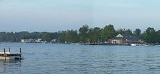
and located along the eastern shore of Chautauqua Lake
. The population was 340 at the 2000 census. Bemus Point is also home of the floating stage with many performers during the summer.
According to the United States Census Bureau
, the village has a total area of 0.4 square miles (1 km²), all of it land.
The village is immediately north of the location where Interstate 86
crosses Chautauqua Lake
. The Village has recently just won their second State football championship.
The extended area commonly known as Bemus Point includes most of the region immediately outside the village. This includes the communities of Ellery Center, Centraila, Driftwood, and Cheney's Point. The extended area offers some of the region's most desirable real estate, due to the unique sunsets visible on the eastern shore of the lake.
from the Land Company in 1805 at a cost of $1.50. He moved his family to the east side of the lake (in the area now known as Bemus Point) on March 9, 1806. The Bemus family lived in a log cabin approximately 500–660 feet northeast of the current ferry landing site.
The ferry located in Bemus Point on Watson Road was founded in 1811 by Thomas Bemus. The original ferry was a raft built by Thomas, and had to be poled across the lake. Today, a cable-drawn ferry exists in its place and is operated by the Chautauqua Lake Historic Vessels Company. Until the nearby bridge (Now part of I-86) opened Oct 30, 1982, the Bemus-Stow Ferry was the only way to cross Chautauqua Lake
. When closed for the winter months, motorist had to travel north-west to Mayville, or south-east to Jamestown to reach Stow. Either way was a 19-mile round trip. Local residents often purchased a seasonal pass to use the ferry, commuting to Lakewood, Sherman, or other areas west of the lake.
Watson Road features many historic houses including the Strok's, Kuntz, and Groths which have been there for over 100 years. Thomas lived on the west side of the lake directly across from Bemus Point, in the area now known as Stow.
Throughout the 1800s, Bemus Point gained popularity as a tourist destination, which promoted its growth and development. By the early 1900s, a dance hall known as the Casino, which still exists under the same name, became a well-known venue for entertainment, particularly big band music. Today Bemus Point is still a popular summer tourist destination, with a large influx of summer population.
In the summer, Bemus Point hosts its 'Bemus Bay Pops' concert which involves many local musicians and is also host to the "Chautauqua Idol", similar to American Idol
.
The Village of Bemus Point was incorporated in 1911.
United States Secretary of State
Bainbridge Colby
died here.
of 2000, there were 340 people, 170 households, and 95 families residing in the village. The population density
was 782.8 people per square mile (305.3/km²). There were 218 housing units at an average density of 501.9 per square mile (195.7/km²). The racial makeup of the village was 97.65% White, 0.88% Native American, 0.59% Asian, 0.29% from other races
, and 0.59% from two or more races. Hispanic or Latino of any race were 0.88% of the population.
There were 170 households out of which 18.8% had children under the age of 18 living with them, 44.1% were married couples
living together, 9.4% had a female householder with no husband present, and 44.1% were non-families. 38.8% of all households were made up of individuals and 24.7% had someone living alone who was 65 years of age or older. The average household size was 2.00 and the average family size was 2.65.
In the village the population was spread out with 17.6% under the age of 18, 4.7% from 18 to 24, 23.5% from 25 to 44, 26.5% from 45 to 64, and 27.6% who were 65 years of age or older. The median age was 47 years. For every 100 females there were 85.8 males. For every 100 females age 18 and over, there were 79.5 males.
The median income for a household in the village was $33,333, and the median income for a family was $46,250. Males had a median income of $37,708 versus $25,625 for females. The per capita income
for the village was $19,943. About 3.9% of families and 7.6% of the population were below the poverty line, including 10.8% of those under age 18 and 9.5% of those age 65 or over.
Chautauqua County, New York
-Major highways:* Interstate 86/New York State Route 17 * Interstate 90 * U.S. Route 20* U.S. Route 62* New York State Route 5* New York State Route 39* New York State Route 60* New York State Route 394...
, New York
New York
New York is a state in the Northeastern region of the United States. It is the nation's third most populous state. New York is bordered by New Jersey and Pennsylvania to the south, and by Connecticut, Massachusetts and Vermont to the east...
, United States
United States
The United States of America is a federal constitutional republic comprising fifty states and a federal district...
. The village is within the Town of Ellery
Ellery, New York
Ellery is a town in Chautauqua County, New York, located northwest of Jamestown, New York and with an extended lakefront on the east side of Chautauqua Lake. In the 2000 Census, Ellery had a population of 4,576.-History:...
and located along the eastern shore of Chautauqua Lake
Chautauqua Lake
Chautauqua Lake is located entirely within Chautauqua County, New York, USA. The lake is approximately long and wide at its greatest width. The surface area is approximately 13,000 acres . The maximum depth is about 78 feet...
. The population was 340 at the 2000 census. Bemus Point is also home of the floating stage with many performers during the summer.
Geography
Bemus Point is located at 42°9′46"N 79°23′28"W (42.162886, -79.391230).According to the United States Census Bureau
United States Census Bureau
The United States Census Bureau is the government agency that is responsible for the United States Census. It also gathers other national demographic and economic data...
, the village has a total area of 0.4 square miles (1 km²), all of it land.
The village is immediately north of the location where Interstate 86
Interstate 86 (east)
Interstate 86 is an Interstate Highway that extends for through northwestern Pennsylvania and southern New York in the United States...
crosses Chautauqua Lake
Chautauqua Lake
Chautauqua Lake is located entirely within Chautauqua County, New York, USA. The lake is approximately long and wide at its greatest width. The surface area is approximately 13,000 acres . The maximum depth is about 78 feet...
. The Village has recently just won their second State football championship.
Community
Bemus point is home to many restaurants including the See Zurh House, the Italian Fisherman, the Surf Club and the Village Casino. Bemus Point also has a 9 hole golf course, tennis courts, basketball courts, a small beach, park and free boat launch. It also is the home of the first ever women's cross county state champions for 2010.The extended area commonly known as Bemus Point includes most of the region immediately outside the village. This includes the communities of Ellery Center, Centraila, Driftwood, and Cheney's Point. The extended area offers some of the region's most desirable real estate, due to the unique sunsets visible on the eastern shore of the lake.
History
The area currently known as Bemus Point was first settled by William Bemus in 1806. Bemus had purchased land on both sides of Chautauqua LakeChautauqua Lake
Chautauqua Lake is located entirely within Chautauqua County, New York, USA. The lake is approximately long and wide at its greatest width. The surface area is approximately 13,000 acres . The maximum depth is about 78 feet...
from the Land Company in 1805 at a cost of $1.50. He moved his family to the east side of the lake (in the area now known as Bemus Point) on March 9, 1806. The Bemus family lived in a log cabin approximately 500–660 feet northeast of the current ferry landing site.
The ferry located in Bemus Point on Watson Road was founded in 1811 by Thomas Bemus. The original ferry was a raft built by Thomas, and had to be poled across the lake. Today, a cable-drawn ferry exists in its place and is operated by the Chautauqua Lake Historic Vessels Company. Until the nearby bridge (Now part of I-86) opened Oct 30, 1982, the Bemus-Stow Ferry was the only way to cross Chautauqua Lake
Chautauqua Lake
Chautauqua Lake is located entirely within Chautauqua County, New York, USA. The lake is approximately long and wide at its greatest width. The surface area is approximately 13,000 acres . The maximum depth is about 78 feet...
. When closed for the winter months, motorist had to travel north-west to Mayville, or south-east to Jamestown to reach Stow. Either way was a 19-mile round trip. Local residents often purchased a seasonal pass to use the ferry, commuting to Lakewood, Sherman, or other areas west of the lake.
Watson Road features many historic houses including the Strok's, Kuntz, and Groths which have been there for over 100 years. Thomas lived on the west side of the lake directly across from Bemus Point, in the area now known as Stow.
Throughout the 1800s, Bemus Point gained popularity as a tourist destination, which promoted its growth and development. By the early 1900s, a dance hall known as the Casino, which still exists under the same name, became a well-known venue for entertainment, particularly big band music. Today Bemus Point is still a popular summer tourist destination, with a large influx of summer population.
In the summer, Bemus Point hosts its 'Bemus Bay Pops' concert which involves many local musicians and is also host to the "Chautauqua Idol", similar to American Idol
American Idol
American Idol, titled American Idol: The Search for a Superstar for the first season, is a reality television singing competition created by Simon Fuller and produced by FremantleMedia North America and 19 Entertainment...
.
The Village of Bemus Point was incorporated in 1911.
United States Secretary of State
United States Secretary of State
The United States Secretary of State is the head of the United States Department of State, concerned with foreign affairs. The Secretary is a member of the Cabinet and the highest-ranking cabinet secretary both in line of succession and order of precedence...
Bainbridge Colby
Bainbridge Colby
Bainbridge Colby was an American lawyer, a founder of the United States Progressive Party and Woodrow Wilson's last Secretary of State.-Life:...
died here.
Demographics
As of the censusCensus
A census is the procedure of systematically acquiring and recording information about the members of a given population. It is a regularly occurring and official count of a particular population. The term is used mostly in connection with national population and housing censuses; other common...
of 2000, there were 340 people, 170 households, and 95 families residing in the village. The population density
Population density
Population density is a measurement of population per unit area or unit volume. It is frequently applied to living organisms, and particularly to humans...
was 782.8 people per square mile (305.3/km²). There were 218 housing units at an average density of 501.9 per square mile (195.7/km²). The racial makeup of the village was 97.65% White, 0.88% Native American, 0.59% Asian, 0.29% from other races
Race (United States Census)
Race and ethnicity in the United States Census, as defined by the Federal Office of Management and Budget and the United States Census Bureau, are self-identification data items in which residents choose the race or races with which they most closely identify, and indicate whether or not they are...
, and 0.59% from two or more races. Hispanic or Latino of any race were 0.88% of the population.
There were 170 households out of which 18.8% had children under the age of 18 living with them, 44.1% were married couples
Marriage
Marriage is a social union or legal contract between people that creates kinship. It is an institution in which interpersonal relationships, usually intimate and sexual, are acknowledged in a variety of ways, depending on the culture or subculture in which it is found...
living together, 9.4% had a female householder with no husband present, and 44.1% were non-families. 38.8% of all households were made up of individuals and 24.7% had someone living alone who was 65 years of age or older. The average household size was 2.00 and the average family size was 2.65.
In the village the population was spread out with 17.6% under the age of 18, 4.7% from 18 to 24, 23.5% from 25 to 44, 26.5% from 45 to 64, and 27.6% who were 65 years of age or older. The median age was 47 years. For every 100 females there were 85.8 males. For every 100 females age 18 and over, there were 79.5 males.
The median income for a household in the village was $33,333, and the median income for a family was $46,250. Males had a median income of $37,708 versus $25,625 for females. The per capita income
Per capita income
Per capita income or income per person is a measure of mean income within an economic aggregate, such as a country or city. It is calculated by taking a measure of all sources of income in the aggregate and dividing it by the total population...
for the village was $19,943. About 3.9% of families and 7.6% of the population were below the poverty line, including 10.8% of those under age 18 and 9.5% of those age 65 or over.
Schools
The entire village is within the Bemus Point Central School District (BPCSD).- Bemus Point Elementary School
- Maple Grove Junior Senior High School (MGHS)