
New York State Route 394
Encyclopedia
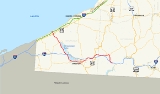
New York State Route 394 (NY 394) is a state highway
located within Cattaraugus
and Chautauqua
Counties in southwestern New York
, United States
. Its western terminus is located on the shore of Lake Erie
at an intersection with NY 5
in the Westfield
hamlet of Barcelona. The eastern terminus is located at an interchange with the Southern Tier Expressway (Interstate 86
or I-86 and NY 17
) at the Coldspring
hamlet of Steamburg
. From Mayville
to Jamestown
, NY 394 follows the western edge of Chautauqua Lake
. East of Jamestown, the route straddles the Southern Tier Expressway and connects to the highway in four different locations, including at its eastern terminus.
The segments of NY 394 between Westfield
and Mayville, as well as east of Jamestown were originally designated as NY 17 in 1924. Six years later, the remainder of current NY 394 gained a pair of designations as part of the 1930 renumbering of state highways in New York; however, by the mid-1940s, the Mayville–Jamestown stretch was solely designated as New York State Route 17J. In the early 1970s, NY 17 was realigned onto the new Southern Tier Expressway east of Jamestown. The former alignment of NY 17 between Jamestown and Steamburg and all of NY 17J were redesignated as NY 394. NY 394 was extended westward to Barcelona shortly afterward. Today the route is also concurrent with part of New York State Bicycle Route 17.
(here part of the Seaway Trail
) in Barcelona, on the shore of Lake Erie
. The route heads to the southeast, paralleling Chautauqua Creek
and meeting the New York State Thruway
(I-90) at exit 60 a quarter-mile (0.4 km) from NY 5. Route 394 crosses over the Thruway and enters the village of Westfield
, passing baseball fields and local businesses ahead of an intersection with U.S. Route 20
(US 20). The road continues through the outskirts of Westfield, passing more local businesses and parks. After the intersection with East Campbell Avenue, Route 394 leaves Westfield and heads into rural regions of Chautauqua County.
 After leaving Westfield, Route 394 heads to the southeast towards Mayville
through predominantly farmland and open fields. Here, Route 394 is known as South Portage Road as it winds its way southeast through the town of Chautauqua
. The highway leaves the vicinity of Chautauqua Creek shortly after entering the town. Roughly 2 miles (3.2 km) from the creek, NY 394 enters the Mayville village limits upon intersecting Beaujean Road. Within the village, Route 394 passes by Chautauqua Lake Central School ahead of a junction with NY 430
, a road ultimately leading westward to Erie, Pennsylvania
. Past the intersection, both NY 394 and NY 430 begin to parallel Chautauqua Lake
as they head southeastward, with NY 394 following the western edge of the water body.
 Outside of Mayville, the highway reenters the town of Chautauqua and goes along the shore of the lake. Route 394 intersects with some local roads as it approaches the Chautauqua Institution
, where it passes the Chautauqua Golf Club just west of the grounds. Just south of the golf club is an access road to a fish hatchery maintained by the state. Route 394 leaves Chautauqua quickly and passes to the east of Willow Run Golf Course. After intersections with County Route 18 (CR 18, named Magnolia–Stedman Road) and CR 16 (Stow Road), Route 394 turns southward and meets the Southern Tier Expressway (I-86
and NY 17
) at exit 8 less than 1 miles (1.6 km) from Bemus Point
.
South of the expressway, Route 394 remains the primary lakeside roadway as it passes through the communities of Quigley Park and Cheney's Point. Route 394 turns back to the southeast at an intersection with CR 43, passing Edward F. Loomis Park and remaining on the now-southern edge of Chautauqua Lake. As the route approaches Lakewood
, it intersects NY 474
, a largely rural roadway linking the Jamestown
area to Wattsburg, Pennsylvania
. NY 394 continues onward through Lakewood and into Jamestown, where the lake comes to an end near an intersection with Jackson Avenue.
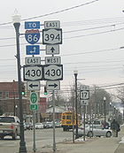
after crossing the Chadakoin River. At this point, eastbound NY 394 shifts one block south to follow Fifth Street while westbound NY 394 remains on Sixth. Between Washington Street and North Main Street, NY 394 is concurrent
with NY 60
, with NY 60 south overlapping NY 394 west on Fifth Street and NY 60 north overlapping NY 394 east on Sixth. The one-way pair remains intact through downtown to Prendergast Avenue, where Route 394 comes back together and shifts south onto Fourth Street. Two blocks later, NY 394 veers onto Second Street and passes south of Jamestown Community College
before exiting the city. The portion of NY 394 within Jamestown from the western city line to Prendergast Avenue is maintained by the city and is the only section of the route not maintained by the New York State Department of Transportation
.
 In nearby Falconer
, the route becomes Main Street and intersects with CR 380, an extension of former NY 380. The highway heads to the northeast through the village, intersecting with local roads before connecting to the Southern Tier Expressway again at exit 13. The road parallels the expressway as both head northeast out of Falconer.
and heads northeast to the hamlet of Kennedy, home to a junction with US 62. Routes 394 and 62 become concurrent and head through Kennedy to Schermerhorn Corners, where US 62 leaves to the north. Route 394 continues eastward, passing into Cattaraugus County
and meeting the Southern Tier Expressway at exit 15 by way of Schoolhouse Road. The segment of Schoolhouse Road between NY 394 and the freeway is designated as NY 953A, an unsigned reference route. Route 394 enters the village of Randolph
roughly 3 miles (5 km) later and intersects with both the Southern Tier Expressway at exit 16 via Main Street (unsigned NY 952M) and NY 241
. Outside of the village, Route 394 separates from the expressway and follows a northeasterly routing to the neighboring village of East Randolph
. Here, the route meets NY 242
as it turns southward toward the Southern Tier Expressway once again.
 Route 394 leaves East Randolph and heads southward through the town of Coldspring
, where it rejoins the corridor of the Southern Tier Expressway about 3.5 miles (5.6 km) from East Randolph. The two highways follow parallel routings for an additional 1.5 miles (2.4 km) to exit 17 on the expressway (at the hamlet of Steamburg
), where Route 394 terminates. Past the interchange, the right-of-way of NY 394 continues southward along the Allegheny Reservoir
past the Onoville Marina to the Pennsylvania state line (a distance of 12.76 miles or 20.54 km) as unsigned NY 950A.
–Mayville
corridor was originally connected by way of a 9 miles (14 km) long Native American
trail. French explorers discovered the trail in 1615 and used it periodically thereafter. In 1749, an expedition under the command of Celeron de Bienville
landed at the mouth of Chautauqua Creek
on Lake Erie
with the intent of claiming the Ohio Valley for the French. They hacked out a road to Chautauqua Lake
through the forests that lined the trail on their way to the Allegheny River
and thus to the Ohio River
.
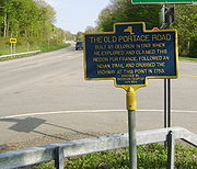
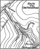 Another French expedition in 1753 converted the portage
road into a military road. The road was still in evidence in 1802 when settlers first moved into the area. They called it the "Old French Road". Remants of the portage road remain to this day: most of NY 394 between the two waterbodies is named Portage Street, and a loop road off NY 394 south of the village of Westfield
is called Old Portage Road.
 When the first set of posted routes in New York
were assigned in 1924, what is now NY 394 from Westfield
to Mayville
, as well as from Jamestown
to Steamburg, was designated as part of NY 17
, a cross-state highway extending across the Southern Tier
from Westfield to New Jersey
. In the 1930 renumbering of state highways in New York, an alternate route of NY 17 from Mayville to Jamestown
was designated as NY 17J from Mayville to Ashville and part of NY 74 from Ashville to Jamestown. In the mid-1930s, NY 17J was extended eastward to rejoin NY 17 at Washington Street in Jamestown, creating an overlap with NY 74. This overlap was eliminated in the mid-1940s when NY 74 was truncated to Ashville. NY 17, meanwhile, was extended to Barcelona to meet NY 5
by 1946.
Construction began on a new limited-access highway through Cattaraugus
and Chautauqua
Counties (part of the modern Southern Tier Expressway) in the mid-1960s. The initial section of the highway, extending from Kennedy (exit 14) to Randolph
(exit 16), opened to traffic by 1967 and became part of a rerouted NY 17 in the late 1960s. Within four years, the expressway had been extended west to Fluvanna (exit 11) and east to Steamburg (exit 18). NY 17 was then realigned to follow the expressway while its former routing from Jamestown to Steamburg, as well as all of NY 17J, was redesignated as NY 394. By 1977, the Southern Tier Expressway was completed up to exit 10 in Bemus Point
.
In the late 1970s, NY 394 was extended northwestward to Barcelona, overlapping NY 17. The concurrency was only temporary as NY 17 was realigned to follow the Southern Tier Expressway from Bemus Point to Mina
once that segment was completed in the early 1980s. On April 1, 1980, ownership and maintenance of NY 394 from Westfield to Barcelona was transferred from Chautauqua County to New York State as part of a highway maintenance swap between the two levels of government.
State highway
State highway, state road or state route can refer to one of three related concepts, two of them related to a state or provincial government in a country that is divided into states or provinces :#A...
located within Cattaraugus
Cattaraugus County, New York
Cattaraugus County is a county located in the U.S. state of New York. As of the 2010 census, the population was 80,317. The county seat is Little Valley.-History:...
and Chautauqua
Chautauqua County, New York
-Major highways:* Interstate 86/New York State Route 17 * Interstate 90 * U.S. Route 20* U.S. Route 62* New York State Route 5* New York State Route 39* New York State Route 60* New York State Route 394...
Counties in southwestern New York
New York
New York is a state in the Northeastern region of the United States. It is the nation's third most populous state. New York is bordered by New Jersey and Pennsylvania to the south, and by Connecticut, Massachusetts and Vermont to the east...
, United States
United States
The United States of America is a federal constitutional republic comprising fifty states and a federal district...
. Its western terminus is located on the shore of Lake Erie
Lake Erie
Lake Erie is the fourth largest lake of the five Great Lakes in North America, and the tenth largest globally. It is the southernmost, shallowest, and smallest by volume of the Great Lakes and therefore also has the shortest average water residence time. It is bounded on the north by the...
at an intersection with NY 5
New York State Route 5
New York State Route 5 is a state highway that extends for across the state of New York in the United States. It begins at the Pennsylvania state line in the Chautauqua County town of Ripley and passes through Buffalo, Syracuse, Utica, Schenectady, and several other smaller cities and...
in the Westfield
Westfield (town), New York
Westfield is a town in the western part Chautauqua County, New York, United States. The population was 5,232 at the 2000 census. Westfield is also the name of a village within the town.- History :...
hamlet of Barcelona. The eastern terminus is located at an interchange with the Southern Tier Expressway (Interstate 86
Interstate 86 (east)
Interstate 86 is an Interstate Highway that extends for through northwestern Pennsylvania and southern New York in the United States...
or I-86 and NY 17
New York State Route 17
New York State Route 17 is a state highway that extends for through the Southern Tier and Downstate regions of New York in the United States...
) at the Coldspring
Coldspring, New York
Coldspring is a town in Cattaraugus County, New York, United States. It is located in the southwest part of the county, west of the City of Salamanca.- History :The first settler arrived around 1818....
hamlet of Steamburg
Steamburg, New York
Steamburg is a hamlet in the town of Coldspring in Cattaraugus County, New York, United States. The community is located at the eastern terminus of New York State Route 394, at I-86 exit 17. Also converging on the hamlet is New York State Reference Route 950A Steamburg is a hamlet in the town of...
. From Mayville
Mayville, New York
-Demographics:As of the census of 2000, there were 1,756 people, 686 households, and 399 families residing in the village. The population density was 875.0 people per square mile . There were 860 housing units at an average density of 428.5 per square mile...
to Jamestown
Jamestown, New York
Jamestown is a city in Chautauqua County, New York in the United States. The population was 31,146 at the 2010 census.The City of Jamestown is adjacent to Town of Ellicott and is at the southern tip of Chautauqua Lake...
, NY 394 follows the western edge of Chautauqua Lake
Chautauqua Lake
Chautauqua Lake is located entirely within Chautauqua County, New York, USA. The lake is approximately long and wide at its greatest width. The surface area is approximately 13,000 acres . The maximum depth is about 78 feet...
. East of Jamestown, the route straddles the Southern Tier Expressway and connects to the highway in four different locations, including at its eastern terminus.
The segments of NY 394 between Westfield
Westfield (village), New York
Westfield is a village in Chautauqua County, New York, United States. USA. The population was 3,481 at the 2010 census.The Village of Westfield lies within the Town of Westfield in the northern part of the county...
and Mayville, as well as east of Jamestown were originally designated as NY 17 in 1924. Six years later, the remainder of current NY 394 gained a pair of designations as part of the 1930 renumbering of state highways in New York; however, by the mid-1940s, the Mayville–Jamestown stretch was solely designated as New York State Route 17J. In the early 1970s, NY 17 was realigned onto the new Southern Tier Expressway east of Jamestown. The former alignment of NY 17 between Jamestown and Steamburg and all of NY 17J were redesignated as NY 394. NY 394 was extended westward to Barcelona shortly afterward. Today the route is also concurrent with part of New York State Bicycle Route 17.
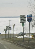
Lake Erie to Mayville
Route 394 begins at an intersection with NY 5New York State Route 5
New York State Route 5 is a state highway that extends for across the state of New York in the United States. It begins at the Pennsylvania state line in the Chautauqua County town of Ripley and passes through Buffalo, Syracuse, Utica, Schenectady, and several other smaller cities and...
(here part of the Seaway Trail
Seaway Trail
The Great Lakes Seaway Trail, formerly named and commonly known as the Seaway Trail, is a National Scenic Byway in the northeastern United States, mostly contained in New York but with a small segment in Pennsylvania...
) in Barcelona, on the shore of Lake Erie
Lake Erie
Lake Erie is the fourth largest lake of the five Great Lakes in North America, and the tenth largest globally. It is the southernmost, shallowest, and smallest by volume of the Great Lakes and therefore also has the shortest average water residence time. It is bounded on the north by the...
. The route heads to the southeast, paralleling Chautauqua Creek
Chautauqua Creek
Chautauqua Creek is a tributary of Lake Erie, approximately long, in the southwestern corner of New York in the United States. The headwaters of the creek rise in the town of Sherman, in Chautauqua County, and flow in a northerly direction through the town and village of Westfield where they empty...
and meeting the New York State Thruway
New York State Thruway
The New York State Thruway is a system of limited-access highways located within the state of New York in the United States. The system, known officially as the Governor Thomas E. Dewey Thruway for former New York Governor Thomas E. Dewey, is operated by the New York State Thruway Authority and...
(I-90) at exit 60 a quarter-mile (0.4 km) from NY 5. Route 394 crosses over the Thruway and enters the village of Westfield
Westfield (village), New York
Westfield is a village in Chautauqua County, New York, United States. USA. The population was 3,481 at the 2010 census.The Village of Westfield lies within the Town of Westfield in the northern part of the county...
, passing baseball fields and local businesses ahead of an intersection with U.S. Route 20
U.S. Route 20 in New York
U.S. Route 20 is a part of the U.S. Highway System that runs from Newport, Oregon, to Boston, Massachusetts. In the U.S. state of New York, US 20 extends from the Pennsylvania state line at Ripley to the Massachusetts state line in the Berkshire Mountains. US 20 is the longest...
(US 20). The road continues through the outskirts of Westfield, passing more local businesses and parks. After the intersection with East Campbell Avenue, Route 394 leaves Westfield and heads into rural regions of Chautauqua County.
Mayville, New York
-Demographics:As of the census of 2000, there were 1,756 people, 686 households, and 399 families residing in the village. The population density was 875.0 people per square mile . There were 860 housing units at an average density of 428.5 per square mile...
through predominantly farmland and open fields. Here, Route 394 is known as South Portage Road as it winds its way southeast through the town of Chautauqua
Chautauqua, New York
Chautauqua is a town in Chautauqua County, New York, U.S. . The population was 4,666 at the 2000 census. The town is named after Chautauqua Lake. The traditional meaning remains 'bag tied in the middle'...
. The highway leaves the vicinity of Chautauqua Creek shortly after entering the town. Roughly 2 miles (3.2 km) from the creek, NY 394 enters the Mayville village limits upon intersecting Beaujean Road. Within the village, Route 394 passes by Chautauqua Lake Central School ahead of a junction with NY 430
New York State Route 430
New York State Route 430 is a state highway located entirely within Chautauqua County, New York, in the United States. Its western terminus is located at the Pennsylvania state line near the hamlet of Findley Lake in the town of Mina. The eastern terminus is located in the city of Jamestown...
, a road ultimately leading westward to Erie, Pennsylvania
Erie, Pennsylvania
Erie is a city located in northwestern Pennsylvania in the United States. Named for the lake and the Native American tribe that resided along its southern shore, Erie is the state's fourth-largest city , with a population of 102,000...
. Past the intersection, both NY 394 and NY 430 begin to parallel Chautauqua Lake
Chautauqua Lake
Chautauqua Lake is located entirely within Chautauqua County, New York, USA. The lake is approximately long and wide at its greatest width. The surface area is approximately 13,000 acres . The maximum depth is about 78 feet...
as they head southeastward, with NY 394 following the western edge of the water body.
Chautauqua Lake
Chautauqua Institution
The Chautauqua Institution is a non-profit adult education center and summer resort located on 750 acres in Chautauqua, New York, 17 miles northwest of Jamestown in the western part of New York State...
, where it passes the Chautauqua Golf Club just west of the grounds. Just south of the golf club is an access road to a fish hatchery maintained by the state. Route 394 leaves Chautauqua quickly and passes to the east of Willow Run Golf Course. After intersections with County Route 18 (CR 18, named Magnolia–Stedman Road) and CR 16 (Stow Road), Route 394 turns southward and meets the Southern Tier Expressway (I-86
Interstate 86 (east)
Interstate 86 is an Interstate Highway that extends for through northwestern Pennsylvania and southern New York in the United States...
and NY 17
New York State Route 17
New York State Route 17 is a state highway that extends for through the Southern Tier and Downstate regions of New York in the United States...
) at exit 8 less than 1 miles (1.6 km) from Bemus Point
Bemus Point, New York
Bemus Point is a village in Chautauqua County, New York, United States. The village is within the Town of Ellery and located along the eastern shore of Chautauqua Lake. The population was 340 at the 2000 census...
.
South of the expressway, Route 394 remains the primary lakeside roadway as it passes through the communities of Quigley Park and Cheney's Point. Route 394 turns back to the southeast at an intersection with CR 43, passing Edward F. Loomis Park and remaining on the now-southern edge of Chautauqua Lake. As the route approaches Lakewood
Lakewood, New York
Lakewood is a village in Chautauqua County, New York, USA. The population was 3,258 at the 2000 census.The Village of Lakewood is located in the northern part of the Town of Busti.-Geography:Lakewood is located at ....
, it intersects NY 474
New York State Route 474
New York State Route 474 is a state highway located entirely in Chautauqua County, in the westernmost corner of New York in the United States...
, a largely rural roadway linking the Jamestown
Jamestown, New York
Jamestown is a city in Chautauqua County, New York in the United States. The population was 31,146 at the 2010 census.The City of Jamestown is adjacent to Town of Ellicott and is at the southern tip of Chautauqua Lake...
area to Wattsburg, Pennsylvania
Wattsburg, Pennsylvania
Wattsburg is a borough in Erie County, Pennsylvania, United States. The population was 378 at the 2000 census. It is part of the Erie Metropolitan Statistical Area.Wattsburg is along the banks of French Creek ....
. NY 394 continues onward through Lakewood and into Jamestown, where the lake comes to an end near an intersection with Jackson Avenue.
Jamestown area
Route 394, initially known as Sixth Street within the city limits, splits into a one-way pairOne-way pair
A one-way pair, one-way couple, or just couplet is a pair of parallel, usually one-way streets that carry opposite directions of a signed route or major traffic flow, or sometimes opposite directions of a bus or streetcar route....
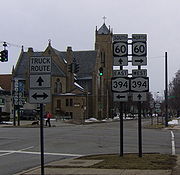
after crossing the Chadakoin River. At this point, eastbound NY 394 shifts one block south to follow Fifth Street while westbound NY 394 remains on Sixth. Between Washington Street and North Main Street, NY 394 is concurrent
Concurrency (road)
A concurrency, overlap, or coincidence in a road network is an instance of one physical road bearing two or more different highway, motorway, or other route numbers...
with NY 60
New York State Route 60
New York State Route 60 is a north–south state highway in Chautauqua County, New York, United States. The southern terminus of the route is at an intersection with U.S. Route 62 south of the city of Jamestown in the town of Kiantone. Its northern terminus is at a junction with NY 5...
, with NY 60 south overlapping NY 394 west on Fifth Street and NY 60 north overlapping NY 394 east on Sixth. The one-way pair remains intact through downtown to Prendergast Avenue, where Route 394 comes back together and shifts south onto Fourth Street. Two blocks later, NY 394 veers onto Second Street and passes south of Jamestown Community College
Jamestown Community College
Jamestown Community College is a two-year college in the SUNY system. JCC has two campuses in Chautauqua County, New York, located in Dunkirk and Jamestown. A third campus serves Cattaraugus County in Olean. A fourth site is located in Warren, Pennsylvania...
before exiting the city. The portion of NY 394 within Jamestown from the western city line to Prendergast Avenue is maintained by the city and is the only section of the route not maintained by the New York State Department of Transportation
New York State Department of Transportation
The New York State Department of Transportation is responsible for the development and operation of highways, railroads, mass transit systems, ports, waterways and aviation facilities in the U.S...
.
Falconer, New York
Falconer is a village in Chautauqua County, New York, United States. The population was 2,540 at the 2000 census.The Village of Falconer is within the Town of Ellicott. Falconer is on the eastern edge of the City of Jamestown, New York.- History :...
, the route becomes Main Street and intersects with CR 380, an extension of former NY 380. The highway heads to the northeast through the village, intersecting with local roads before connecting to the Southern Tier Expressway again at exit 13. The road parallels the expressway as both head northeast out of Falconer.
Poland and Cattaraugus County
Outside of Falconer, Route 394 enters the town of PolandPoland, Chautauqua County, New York
Poland is a town in Chautauqua County, New York, U.S. The population was 2,467 at the 2000 census.The Town of Poland is on the county's eastern border.-History:The town was first settled in 1804....
and heads northeast to the hamlet of Kennedy, home to a junction with US 62. Routes 394 and 62 become concurrent and head through Kennedy to Schermerhorn Corners, where US 62 leaves to the north. Route 394 continues eastward, passing into Cattaraugus County
Cattaraugus County, New York
Cattaraugus County is a county located in the U.S. state of New York. As of the 2010 census, the population was 80,317. The county seat is Little Valley.-History:...
and meeting the Southern Tier Expressway at exit 15 by way of Schoolhouse Road. The segment of Schoolhouse Road between NY 394 and the freeway is designated as NY 953A, an unsigned reference route. Route 394 enters the village of Randolph
Randolph (village), New York
Randolph is currently a village in Cattaraugus County, New York, USA. The population was 1,316 at the 2000 census.The Village of Randolph is within the Town of Randolph...
roughly 3 miles (5 km) later and intersects with both the Southern Tier Expressway at exit 16 via Main Street (unsigned NY 952M) and NY 241
New York State Route 241
New York State Route 241 is a north–south state highway in Cattaraugus County, New York, United States. The southern terminus of the route is at an intersection with NY 394 in the village of Randolph and its northern terminus is at a junction with U.S. Route 62 in the town of...
. Outside of the village, Route 394 separates from the expressway and follows a northeasterly routing to the neighboring village of East Randolph
East Randolph, New York
East Randolph is currently a village in Cattaraugus County, New York, United States. The population was 630 at the 2000 census.The Village of East Randolph is adjacent to the northeast part of the Village of Randolph and is mostly within the Town of Randolph, with a small part inside the Town of...
. Here, the route meets NY 242
New York State Route 242
New York State Route 242 is a state highway that runs across Cattaraugus County, New York, in the United States. Although signed as an east–west route, it takes a more northeast–southwest course across the county from NY 394 near the village of Randolph to NY 16 in Machias...
as it turns southward toward the Southern Tier Expressway once again.
Coldspring, New York
Coldspring is a town in Cattaraugus County, New York, United States. It is located in the southwest part of the county, west of the City of Salamanca.- History :The first settler arrived around 1818....
, where it rejoins the corridor of the Southern Tier Expressway about 3.5 miles (5.6 km) from East Randolph. The two highways follow parallel routings for an additional 1.5 miles (2.4 km) to exit 17 on the expressway (at the hamlet of Steamburg
Steamburg, New York
Steamburg is a hamlet in the town of Coldspring in Cattaraugus County, New York, United States. The community is located at the eastern terminus of New York State Route 394, at I-86 exit 17. Also converging on the hamlet is New York State Reference Route 950A Steamburg is a hamlet in the town of...
), where Route 394 terminates. Past the interchange, the right-of-way of NY 394 continues southward along the Allegheny Reservoir
Allegheny Reservoir
The Allegheny Reservoir is a reservoir along the Allegheny River in Pennsylvania and New York, USA. It was created in 1965 by the construction of the Kinzua Dam along the river.-History:...
past the Onoville Marina to the Pennsylvania state line (a distance of 12.76 miles or 20.54 km) as unsigned NY 950A.
Westfield–Mayville corridor
The WestfieldWestfield (town), New York
Westfield is a town in the western part Chautauqua County, New York, United States. The population was 5,232 at the 2000 census. Westfield is also the name of a village within the town.- History :...
–Mayville
Mayville, New York
-Demographics:As of the census of 2000, there were 1,756 people, 686 households, and 399 families residing in the village. The population density was 875.0 people per square mile . There were 860 housing units at an average density of 428.5 per square mile...
corridor was originally connected by way of a 9 miles (14 km) long Native American
Indigenous peoples of the Americas
The indigenous peoples of the Americas are the pre-Columbian inhabitants of North and South America, their descendants and other ethnic groups who are identified with those peoples. Indigenous peoples are known in Canada as Aboriginal peoples, and in the United States as Native Americans...
trail. French explorers discovered the trail in 1615 and used it periodically thereafter. In 1749, an expedition under the command of Celeron de Bienville
Celeron de Bienville
Pierre-Joseph Céloron de Blainville was aFrench Canadian Officer of Marine. In 1739-1740 he led a detachment to Louisiana to fight the Chickasaw in the abortive Chickasaw Campaign of 1739...
landed at the mouth of Chautauqua Creek
Chautauqua Creek
Chautauqua Creek is a tributary of Lake Erie, approximately long, in the southwestern corner of New York in the United States. The headwaters of the creek rise in the town of Sherman, in Chautauqua County, and flow in a northerly direction through the town and village of Westfield where they empty...
on Lake Erie
Lake Erie
Lake Erie is the fourth largest lake of the five Great Lakes in North America, and the tenth largest globally. It is the southernmost, shallowest, and smallest by volume of the Great Lakes and therefore also has the shortest average water residence time. It is bounded on the north by the...
with the intent of claiming the Ohio Valley for the French. They hacked out a road to Chautauqua Lake
Chautauqua Lake
Chautauqua Lake is located entirely within Chautauqua County, New York, USA. The lake is approximately long and wide at its greatest width. The surface area is approximately 13,000 acres . The maximum depth is about 78 feet...
through the forests that lined the trail on their way to the Allegheny River
Allegheny River
The Allegheny River is a principal tributary of the Ohio River; it is located in the Eastern United States. The Allegheny River joins with the Monongahela River to form the Ohio River at the "Point" of Point State Park in Downtown Pittsburgh, Pennsylvania...
and thus to the Ohio River
Ohio River
The Ohio River is the largest tributary, by volume, of the Mississippi River. At the confluence, the Ohio is even bigger than the Mississippi and, thus, is hydrologically the main stream of the whole river system, including the Allegheny River further upstream...
.
Portage
Portage or portaging refers to the practice of carrying watercraft or cargo over land to avoid river obstacles, or between two bodies of water. A place where this carrying occurs is also called a portage; a person doing the carrying is called a porter.The English word portage is derived from the...
road into a military road. The road was still in evidence in 1802 when settlers first moved into the area. They called it the "Old French Road". Remants of the portage road remain to this day: most of NY 394 between the two waterbodies is named Portage Street, and a loop road off NY 394 south of the village of Westfield
Westfield (village), New York
Westfield is a village in Chautauqua County, New York, United States. USA. The population was 3,481 at the 2010 census.The Village of Westfield lies within the Town of Westfield in the northern part of the county...
is called Old Portage Road.
Designations
New York
New York is a state in the Northeastern region of the United States. It is the nation's third most populous state. New York is bordered by New Jersey and Pennsylvania to the south, and by Connecticut, Massachusetts and Vermont to the east...
were assigned in 1924, what is now NY 394 from Westfield
Westfield (village), New York
Westfield is a village in Chautauqua County, New York, United States. USA. The population was 3,481 at the 2010 census.The Village of Westfield lies within the Town of Westfield in the northern part of the county...
to Mayville
Mayville, New York
-Demographics:As of the census of 2000, there were 1,756 people, 686 households, and 399 families residing in the village. The population density was 875.0 people per square mile . There were 860 housing units at an average density of 428.5 per square mile...
, as well as from Jamestown
Jamestown, New York
Jamestown is a city in Chautauqua County, New York in the United States. The population was 31,146 at the 2010 census.The City of Jamestown is adjacent to Town of Ellicott and is at the southern tip of Chautauqua Lake...
to Steamburg, was designated as part of NY 17
New York State Route 17
New York State Route 17 is a state highway that extends for through the Southern Tier and Downstate regions of New York in the United States...
, a cross-state highway extending across the Southern Tier
Southern Tier
The Southern Tier is a geographical term that refers to the counties of New York State west of the Catskill Mountains along the northern border of Pennsylvania. It is a loosely defined term that generally includes the counties that border Pennsylvania west of Delaware County inclusive...
from Westfield to New Jersey
New Jersey
New Jersey is a state in the Northeastern and Middle Atlantic regions of the United States. , its population was 8,791,894. It is bordered on the north and east by the state of New York, on the southeast and south by the Atlantic Ocean, on the west by Pennsylvania and on the southwest by Delaware...
. In the 1930 renumbering of state highways in New York, an alternate route of NY 17 from Mayville to Jamestown
Jamestown, New York
Jamestown is a city in Chautauqua County, New York in the United States. The population was 31,146 at the 2010 census.The City of Jamestown is adjacent to Town of Ellicott and is at the southern tip of Chautauqua Lake...
was designated as NY 17J from Mayville to Ashville and part of NY 74 from Ashville to Jamestown. In the mid-1930s, NY 17J was extended eastward to rejoin NY 17 at Washington Street in Jamestown, creating an overlap with NY 74. This overlap was eliminated in the mid-1940s when NY 74 was truncated to Ashville. NY 17, meanwhile, was extended to Barcelona to meet NY 5
New York State Route 5
New York State Route 5 is a state highway that extends for across the state of New York in the United States. It begins at the Pennsylvania state line in the Chautauqua County town of Ripley and passes through Buffalo, Syracuse, Utica, Schenectady, and several other smaller cities and...
by 1946.
Construction began on a new limited-access highway through Cattaraugus
Cattaraugus County, New York
Cattaraugus County is a county located in the U.S. state of New York. As of the 2010 census, the population was 80,317. The county seat is Little Valley.-History:...
and Chautauqua
Chautauqua County, New York
-Major highways:* Interstate 86/New York State Route 17 * Interstate 90 * U.S. Route 20* U.S. Route 62* New York State Route 5* New York State Route 39* New York State Route 60* New York State Route 394...
Counties (part of the modern Southern Tier Expressway) in the mid-1960s. The initial section of the highway, extending from Kennedy (exit 14) to Randolph
Randolph (village), New York
Randolph is currently a village in Cattaraugus County, New York, USA. The population was 1,316 at the 2000 census.The Village of Randolph is within the Town of Randolph...
(exit 16), opened to traffic by 1967 and became part of a rerouted NY 17 in the late 1960s. Within four years, the expressway had been extended west to Fluvanna (exit 11) and east to Steamburg (exit 18). NY 17 was then realigned to follow the expressway while its former routing from Jamestown to Steamburg, as well as all of NY 17J, was redesignated as NY 394. By 1977, the Southern Tier Expressway was completed up to exit 10 in Bemus Point
Bemus Point, New York
Bemus Point is a village in Chautauqua County, New York, United States. The village is within the Town of Ellery and located along the eastern shore of Chautauqua Lake. The population was 340 at the 2000 census...
.
In the late 1970s, NY 394 was extended northwestward to Barcelona, overlapping NY 17. The concurrency was only temporary as NY 17 was realigned to follow the Southern Tier Expressway from Bemus Point to Mina
Mina, New York
Mina is a town in Chautauqua County, New York, USA. The population was 1,176 at the 2000 census.The Town of Mina is at the western county border. The town is best known as a summer resort area...
once that segment was completed in the early 1980s. On April 1, 1980, ownership and maintenance of NY 394 from Westfield to Barcelona was transferred from Chautauqua County to New York State as part of a highway maintenance swap between the two levels of government.