
New York State Route 280
Encyclopedia
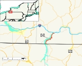
New York State Route 280 (NY 280) is a 11.59 miles (18.65 km) long north–south state highway
in rural Cattaraugus County, New York
, United States
. The southern terminus of the route is at the Pennsylvania state line in South Valley
, where it becomes Pennsylvania Route 346
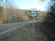
. The northern terminus is at exit 18 on the Southern Tier Expressway (Interstate 86
or I-86 and NY 17
) in Coldspring
, west of Salamanca
. NY 280 follows both the eastern edge of the Allegheny Reservoir
and the western boundary of Allegany State Park
for its entire length.
When NY 280 was originally assigned as part of the 1930 renumbering of state highways in New York, it was little more than a short spur route off of NY 17
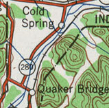
that followed the Allegheny River
south to the hamlet of Quaker Bridge. In 1965, the Kinzua Dam
was completed, leading to the creation of the Allegheny Reservoir
and the inundation of much of NY 280. As a result, the route was shifted onto a new alignment that was constructed along the eastern edge of the reservoir.
 At the Pennsylvania state line in South Valley
, Pennsylvania Route 346
exits the Allegheny National Forest
and becomes NY 280 upon entering New York
. The route heads north along the eastern edge of the Allegheny Reservoir
as East Bank Perimeter Road, clipping the southwestern corner of Allegany State Park
prior to entering the Allegany Indian Reservation. NY 280 passes in and out of the park once more before turning to the east toward Quaker Lake as it enters the town of Coldspring
. At Quaker Lake, NY 280 penetrates the park boundary once more and intersects Allegany State Park Route 3 at the Quaker Run entrance. Here, NY 280 turns north, traversing a small waterway separating Quaker Lake from the reservoir before reentering the Allegany Indian Reservation limits.
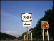
Between ASP Route 3 and exit 18 of the Southern Tier Expressway (I-86
and NY 17
), NY 280 continues to straddle both the eastern extent of the Allegheny Reservoir and the western perimeter of Allegany State Park before terminating at a diamond interchange
with the Southern Tier Expressway. The West Bank Perimeter Road (unsigned NY 950A), which parallels NY 280 from the Pennsylvania
line northward on the western bank of the reservoir, meets the expressway at exit 17 2.5 miles (4 km) to the west.
 NY 280 was assigned as part of the 1930 renumbering of state highways in New York to a short roadway connecting NY 17
, then an at-grade highway, to the now-submerged hamlets of Cold Spring and Quaker Bridge along the western bank of the Allegheny River
. The designation ended in Quaker Bridge, a community situated on the eastern riverbank near the modern junction of NY 280 and Allegany State Park Route 3. NY 280 remained relatively unchanged up through the early 1960s.
In October 1960, ground was broken on the Kinzua Dam
, which would dam the Allegheny River downriver from NY 280 at a point east of Warren, Pennsylvania
. The structure was completed on December 13, 1965, leading to the creation of the Allegheny Reservoir
. Much of NY 280 was inundated by the new reservoir, as were Cold Spring, Quaker Bridge, and a significant portion of Pennsylvania Route 346
(PA 346) that ran along the river in Warren County
. As a result, new alignments were built for both NY 280 and PA 346 along the eastern edge of the new reservoir. Construction of NY 280's new alignment began in 1965 and was completed by 1968. NY 280 now began at the realigned PA 346 at the state line and ended at exit 18 of the Southern Tier Expressway, which was built between Steamburg
and Salamanca
during the mid-1960s.
State highway
State highway, state road or state route can refer to one of three related concepts, two of them related to a state or provincial government in a country that is divided into states or provinces :#A...
in rural Cattaraugus County, New York
Cattaraugus County, New York
Cattaraugus County is a county located in the U.S. state of New York. As of the 2010 census, the population was 80,317. The county seat is Little Valley.-History:...
, United States
United States
The United States of America is a federal constitutional republic comprising fifty states and a federal district...
. The southern terminus of the route is at the Pennsylvania state line in South Valley
South Valley, New York
South Valley is a town in Cattaraugus County, New York, United States. The population was 302 at the 2000 census. The name is from the town's geographical attributes.The Town of South Valley is in the southwest corner of the county...
, where it becomes Pennsylvania Route 346
Pennsylvania Route 346
Pennsylvania Route 346 is a state highway located in Warren and McKean counties in Pennsylvania, United States The western terminus is at the New York state line in the Allegheny National Forest, where it becomes New York State Route 280...
. The northern terminus is at exit 18 on the Southern Tier Expressway (Interstate 86
Interstate 86 (east)
Interstate 86 is an Interstate Highway that extends for through northwestern Pennsylvania and southern New York in the United States...
or I-86 and NY 17
New York State Route 17
New York State Route 17 is a state highway that extends for through the Southern Tier and Downstate regions of New York in the United States...
) in Coldspring
Coldspring, New York
Coldspring is a town in Cattaraugus County, New York, United States. It is located in the southwest part of the county, west of the City of Salamanca.- History :The first settler arrived around 1818....
, west of Salamanca
Salamanca (city), New York
Salamanca is a city in Cattaraugus County, New York, United States, located inside the Allegany Indian Reservation. The population was 6,097 at the 2000 census.-Geography:...
. NY 280 follows both the eastern edge of the Allegheny Reservoir
Allegheny Reservoir
The Allegheny Reservoir is a reservoir along the Allegheny River in Pennsylvania and New York, USA. It was created in 1965 by the construction of the Kinzua Dam along the river.-History:...
and the western boundary of Allegany State Park
Allegany State Park
Allegany State Park is a state park in western New York State, located in Cattaraugus County just north of Allegheny National Forest in Pennsylvania. The park is divided into two sections: The Red House Area and the Quaker Run Area. It lies within the Allegheny Highlands forests ecoregion.The Red...
for its entire length.
When NY 280 was originally assigned as part of the 1930 renumbering of state highways in New York, it was little more than a short spur route off of NY 17
New York State Route 17
New York State Route 17 is a state highway that extends for through the Southern Tier and Downstate regions of New York in the United States...
that followed the Allegheny River
Allegheny River
The Allegheny River is a principal tributary of the Ohio River; it is located in the Eastern United States. The Allegheny River joins with the Monongahela River to form the Ohio River at the "Point" of Point State Park in Downtown Pittsburgh, Pennsylvania...
south to the hamlet of Quaker Bridge. In 1965, the Kinzua Dam
Kinzua Dam
The Kinzua Dam, in the Allegheny National Forest in Warren County, Pennsylvania, is one of the largest dams in the United States east of the Mississippi River....
was completed, leading to the creation of the Allegheny Reservoir
Allegheny Reservoir
The Allegheny Reservoir is a reservoir along the Allegheny River in Pennsylvania and New York, USA. It was created in 1965 by the construction of the Kinzua Dam along the river.-History:...
and the inundation of much of NY 280. As a result, the route was shifted onto a new alignment that was constructed along the eastern edge of the reservoir.
Route description
South Valley, New York
South Valley is a town in Cattaraugus County, New York, United States. The population was 302 at the 2000 census. The name is from the town's geographical attributes.The Town of South Valley is in the southwest corner of the county...
, Pennsylvania Route 346
Pennsylvania Route 346
Pennsylvania Route 346 is a state highway located in Warren and McKean counties in Pennsylvania, United States The western terminus is at the New York state line in the Allegheny National Forest, where it becomes New York State Route 280...
exits the Allegheny National Forest
Allegheny National Forest
The Allegheny National Forest is a National Forest located in northwestern Pennsylvania. The forest covers of land. Within the forest is Kinzua Dam, which impounds the Allegheny River to form Allegheny Reservoir. The administrative headquarters for the Allegheny National Forest is located in Warren...
and becomes NY 280 upon entering New York
New York
New York is a state in the Northeastern region of the United States. It is the nation's third most populous state. New York is bordered by New Jersey and Pennsylvania to the south, and by Connecticut, Massachusetts and Vermont to the east...
. The route heads north along the eastern edge of the Allegheny Reservoir
Allegheny Reservoir
The Allegheny Reservoir is a reservoir along the Allegheny River in Pennsylvania and New York, USA. It was created in 1965 by the construction of the Kinzua Dam along the river.-History:...
as East Bank Perimeter Road, clipping the southwestern corner of Allegany State Park
Allegany State Park
Allegany State Park is a state park in western New York State, located in Cattaraugus County just north of Allegheny National Forest in Pennsylvania. The park is divided into two sections: The Red House Area and the Quaker Run Area. It lies within the Allegheny Highlands forests ecoregion.The Red...
prior to entering the Allegany Indian Reservation. NY 280 passes in and out of the park once more before turning to the east toward Quaker Lake as it enters the town of Coldspring
Coldspring, New York
Coldspring is a town in Cattaraugus County, New York, United States. It is located in the southwest part of the county, west of the City of Salamanca.- History :The first settler arrived around 1818....
. At Quaker Lake, NY 280 penetrates the park boundary once more and intersects Allegany State Park Route 3 at the Quaker Run entrance. Here, NY 280 turns north, traversing a small waterway separating Quaker Lake from the reservoir before reentering the Allegany Indian Reservation limits.
Between ASP Route 3 and exit 18 of the Southern Tier Expressway (I-86
Interstate 86 (east)
Interstate 86 is an Interstate Highway that extends for through northwestern Pennsylvania and southern New York in the United States...
and NY 17
New York State Route 17
New York State Route 17 is a state highway that extends for through the Southern Tier and Downstate regions of New York in the United States...
), NY 280 continues to straddle both the eastern extent of the Allegheny Reservoir and the western perimeter of Allegany State Park before terminating at a diamond interchange
Diamond interchange
A diamond interchange is a common type of road junction, used where a freeway crosses a minor road. The freeway itself is grade-separated from the minor road, one crossing the other over a bridge...
with the Southern Tier Expressway. The West Bank Perimeter Road (unsigned NY 950A), which parallels NY 280 from the Pennsylvania
Pennsylvania
The Commonwealth of Pennsylvania is a U.S. state that is located in the Northeastern and Mid-Atlantic regions of the United States. The state borders Delaware and Maryland to the south, West Virginia to the southwest, Ohio to the west, New York and Ontario, Canada, to the north, and New Jersey to...
line northward on the western bank of the reservoir, meets the expressway at exit 17 2.5 miles (4 km) to the west.
History
New York State Route 17
New York State Route 17 is a state highway that extends for through the Southern Tier and Downstate regions of New York in the United States...
, then an at-grade highway, to the now-submerged hamlets of Cold Spring and Quaker Bridge along the western bank of the Allegheny River
Allegheny River
The Allegheny River is a principal tributary of the Ohio River; it is located in the Eastern United States. The Allegheny River joins with the Monongahela River to form the Ohio River at the "Point" of Point State Park in Downtown Pittsburgh, Pennsylvania...
. The designation ended in Quaker Bridge, a community situated on the eastern riverbank near the modern junction of NY 280 and Allegany State Park Route 3. NY 280 remained relatively unchanged up through the early 1960s.
In October 1960, ground was broken on the Kinzua Dam
Kinzua Dam
The Kinzua Dam, in the Allegheny National Forest in Warren County, Pennsylvania, is one of the largest dams in the United States east of the Mississippi River....
, which would dam the Allegheny River downriver from NY 280 at a point east of Warren, Pennsylvania
Warren, Pennsylvania
Warren is a city in Warren County, Pennsylvania, United States, located along the Allegheny River. The population was 9,710 at the 2010 census. It is the county seat of Warren County. It is home to the headquarters of the Allegheny National Forest and the Cornplanter State Forest...
. The structure was completed on December 13, 1965, leading to the creation of the Allegheny Reservoir
Allegheny Reservoir
The Allegheny Reservoir is a reservoir along the Allegheny River in Pennsylvania and New York, USA. It was created in 1965 by the construction of the Kinzua Dam along the river.-History:...
. Much of NY 280 was inundated by the new reservoir, as were Cold Spring, Quaker Bridge, and a significant portion of Pennsylvania Route 346
Pennsylvania Route 346
Pennsylvania Route 346 is a state highway located in Warren and McKean counties in Pennsylvania, United States The western terminus is at the New York state line in the Allegheny National Forest, where it becomes New York State Route 280...
(PA 346) that ran along the river in Warren County
Warren County, New York
Warren County is a county in the U.S. state of New York. It is part of the Glens Falls, New York, Metropolitan Statistical Area. As of the 2010 census, the population was 65,707. It is named in honor of General Joseph Warren, an American Revolutionary War hero of the Battle of Bunker Hill...
. As a result, new alignments were built for both NY 280 and PA 346 along the eastern edge of the new reservoir. Construction of NY 280's new alignment began in 1965 and was completed by 1968. NY 280 now began at the realigned PA 346 at the state line and ended at exit 18 of the Southern Tier Expressway, which was built between Steamburg
Steamburg, New York
Steamburg is a hamlet in the town of Coldspring in Cattaraugus County, New York, United States. The community is located at the eastern terminus of New York State Route 394, at I-86 exit 17. Also converging on the hamlet is New York State Reference Route 950A Steamburg is a hamlet in the town of...
and Salamanca
Salamanca (city), New York
Salamanca is a city in Cattaraugus County, New York, United States, located inside the Allegany Indian Reservation. The population was 6,097 at the 2000 census.-Geography:...
during the mid-1960s.
Major intersections