

New York State Route 17C
Encyclopedia
New York State Route 17C (NY 17C) is a state highway
in the Southern Tier
of New York
. Its western terminus is at an intersection with NY 34
in Waverly
, Tioga County
while its eastern terminus is at an intersection with U.S. Route 11 in Binghamton
, Broome County
. The route runs concurrently
with NY 96
for a block in Owego
and for a few blocks with NY 26
in Endicott
.
The stretch between Waverly and Owego is the former NY 17
, as it was routed prior to the opening of the Southern Tier Expressway. The stretch from NY 96 to Binghamton is the original routing of NY 17C and serves as an alternate route between Owego and the Triple Cities.
, but there are street signs along Chemung Street that say "Route 17C" as far west as the Shepherd Hills Golf Course, near the Chemung County
line. There is little, if any, evidence that New York state ever signed the highway that far west.
From Waverly, the route passes through the Ellistown area and runs parallel to and north of the Southern Tier Expressway. In fact, this part of the highway was Route 17 prior to the opening of the expressway in the 1970s.
 Where the expressway crosses the Susquehanna River
just south of the Cannon Hole area, NY 17C stays on the north side of the river, bypassing the Cannon Hole neighborhood and the hamlet of Barton within the town of the same name
. NY 282
runs south from NY 17C about midway between the Tioga
hamlets of Smithboro and Tioga Center. In Tioga Center, NY 17C is the southern terminus of Halsey Valley Road (County Road 7), which was New York's first NY 225
.
The highway becomes Main Street in Owego
, entering the village near the fairgrounds. At the village's main square, NY 17C meets NY 96
. The two routes form a concurrency
for a short distance along the one-way sections of Court Street (westbound) and Park Street (eastbound) around the Tioga County Courthouse before splitting at Front Street. NY 96 continues across the Susquehanna River to access NY 17 and NY 434
while NY 17C continues east on Front Street through an old residential area. This was where the original Route 17C started, as pre-expressway Route 17 followed Route 96 to a routing (now NY 434) across the river.
In the eastern part of the village, NY 17C breaks from Front Street and continues straight onto Fifth Avenue, following the north bank of the river as it progresses. The highway between the Front Street/Fifth Avenue intersection and the NY 17
access road near Hickories Park is well-developed with retail establishments.
For the next several miles, the highway runs alongside the Norfolk Southern Railway
tracks, which separate it from the north bank of the river. Near Campville, the highway serves as the northern terminus of NY 962J
, a short reference route traversing the Susquehanna River
. Although most reference routes are unsigned, NY 962J is one of four within the state that is erroneously signed as a touring route. The route, a connector between Campville and Apalachin
over the Susquehanna that opened in 2001, is known locally as the "Millennium Bridge".
as West Main Street, near the En-Joie Golf Course, former site of the PGA's annual B.C. Open
until 2005. This section has been rebuilt within the last few years. Further along its path, 17C runs concurrently
with NY 26
for approximately one mile in the village between Nanticoke/Exchange Avenues and McKinley Avenue before Route 26 continues to the south. West Main Street becomes East Main Street east of Nanticoke Avenue.
Between Endicott and Johnson City
, NY 17C is split into one-way sections, with each serving as a frontage road for the expressway. While in this configuration, NY 17C is known as the George F. Highway.
 The divided sections of the highway rejoin each other as Main Street west of Johnson City in the hamlet of Westover. This portion of NY 17C is urban and heavily commercial in character as it forms the primary west–east route through Johnson City and Binghamton
. There are arches over the highway at either end of Johnson City commemorating the village's role as home to the former Endicott-Johnson Shoe Corporation
.
NY 17C ends at U.S. Route 11 in Binghamton, just west of the Chenango River
. Main Street, however, continues east for an additional 80 yards (73.2 m) to the Court Street Bridge
as part of US 11.
and Owego
was originally designated as part of Route 4, an unsigned legislative route
, by the New York State Legislature in 1908. When the first set of posted routes in New York
were assigned in 1924, most of legislative Route 4—including from Waverly to Owego—became part of NY 17
. In the 1930 renumbering of state highways in New York, NY 17 was left as-is from Waverly to Owego while NY 17C was assigned to the portion of its current alignment east of Owego.
On January 1, 1970, NY 17 was officially rerouted onto the new Southern Tier Expressway (STE) between Waverly and Vestal
even though the section of the freeway between Waverly and Nichols
had yet to be completed. In actuality, NY 17 continued to follow its original surface alignment from Waverly to Nichols, where it used a portion of NY 282
to reach the freeway. The former surface routing of NY 17 from Nichols to Owego became part of an extended NY 17C ca. 1971. The Waverly–Nichols segment of the STE was completed ca. 1974, at which time NY 17 was realigned to follow the freeway while NY 17C was extended west over NY 17's former alignment to Waverly.
State highway
State highway, state road or state route can refer to one of three related concepts, two of them related to a state or provincial government in a country that is divided into states or provinces :#A...
in the Southern Tier
Southern Tier
The Southern Tier is a geographical term that refers to the counties of New York State west of the Catskill Mountains along the northern border of Pennsylvania. It is a loosely defined term that generally includes the counties that border Pennsylvania west of Delaware County inclusive...
of New York
New York
New York is a state in the Northeastern region of the United States. It is the nation's third most populous state. New York is bordered by New Jersey and Pennsylvania to the south, and by Connecticut, Massachusetts and Vermont to the east...
. Its western terminus is at an intersection with NY 34
New York State Route 34
New York State Route 34 is a north–south New York state route located in Central New York. Its southern terminus is at the Pennsylvania state line in the village of Waverly, where it connects to Pennsylvania Route 199 and meets NY 17...
in Waverly
Waverly, Tioga County, New York
----Waverly is the largest village in Tioga County, New York, United States. It is located southeast of Elmira in the Southern Tier region. This village was incorporated as the southwest part of the town of Barton in 1854...
, Tioga County
Tioga County, New York
As of the census of 2010, there were 51,125 people residing in the county, with 22,203 housing units, of these 20,350 occupied, 1,853 vacant. The population density was 98 people per square mile...
while its eastern terminus is at an intersection with U.S. Route 11 in Binghamton
Binghamton, New York
Binghamton is a city in the Southern Tier of New York in the United States. It is near the Pennsylvania border, in a bowl-shaped valley at the confluence of the Susquehanna and Chenango Rivers...
, Broome County
Broome County, New York
Broome County is a county located in the U.S. state of New York. As of the 2010 census, the population was 200,600. It was named in honor of John Broome, who was lieutenant governor in 1806 when Broome County was established. Its county seat is Binghamton, which is also its major city. The current...
. The route runs concurrently
Concurrency (road)
A concurrency, overlap, or coincidence in a road network is an instance of one physical road bearing two or more different highway, motorway, or other route numbers...
with NY 96
New York State Route 96
New York State Route 96 is a northwest–southeast state highway in the Finger Lakes region of New York in the United States. The southern terminus of the route is at an interchange with NY 17 in the Southern Tier village of Owego, Tioga County. Its northern terminus is at a junction with...
for a block in Owego
Owego (village), New York
Owego is a village in and the county seat of Tioga County, New York, USA. The population was 3,911 at the 2000 census. It is part of the Binghamton Metropolitan Statistical Area...
and for a few blocks with NY 26
New York State Route 26
New York State Route 26 is a north–south state highway that runs for through Central New York in the United States. Its southern terminus is located at the Pennsylvania state line south of the town of Vestal in Broome County, where it becomes Pennsylvania Route 267...
in Endicott
Endicott, New York
Endicott is a village in Broome County, New York, United States. The population was 13,038 at the 2000 census. It is part of the Binghamton Metropolitan Statistical Area. The village is named after Henry B...
.
The stretch between Waverly and Owego is the former NY 17
New York State Route 17
New York State Route 17 is a state highway that extends for through the Southern Tier and Downstate regions of New York in the United States...
, as it was routed prior to the opening of the Southern Tier Expressway. The stretch from NY 96 to Binghamton is the original routing of NY 17C and serves as an alternate route between Owego and the Triple Cities.
Tioga County
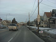
NY 17C officially runs east from the intersection with Route 34 at Chemung Street and Cayuta Avenue in the east side of WaverlyWaverly, Tioga County, New York
----Waverly is the largest village in Tioga County, New York, United States. It is located southeast of Elmira in the Southern Tier region. This village was incorporated as the southwest part of the town of Barton in 1854...
, but there are street signs along Chemung Street that say "Route 17C" as far west as the Shepherd Hills Golf Course, near the Chemung County
Chemung County, New York
Chemung County is a county located in the U.S. state of New York. It is part of the 'Elmira, New York Metropolitan Statistical Area' which encompasses all of Chemung County. As of the 2010 census, the population was 88,830. Its name is derived from the name of a Delaware Indian village . Its...
line. There is little, if any, evidence that New York state ever signed the highway that far west.
From Waverly, the route passes through the Ellistown area and runs parallel to and north of the Southern Tier Expressway. In fact, this part of the highway was Route 17 prior to the opening of the expressway in the 1970s.
Susquehanna River
The Susquehanna River is a river located in the northeastern United States. At long, it is the longest river on the American east coast that drains into the Atlantic Ocean, and with its watershed it is the 16th largest river in the United States, and the longest river in the continental United...
just south of the Cannon Hole area, NY 17C stays on the north side of the river, bypassing the Cannon Hole neighborhood and the hamlet of Barton within the town of the same name
Barton, New York
Barton is a town in southwestern Tioga County, New York, USA. The population was 9,066 at the 2000 census. It is southeast of Elmira.- History :The Sullivan Expedition of 1779 passed through this region. The first settlers arrived around 1791....
. NY 282
New York State Route 282
New York State Route 282 is a state highway in the Southern Tier of New York in the United States. This highway is a north–south roadway connecting NY 17C to the Pennsylvania state line, where it becomes Pennsylvania Route 187.NY 282 is located entirely within Tioga...
runs south from NY 17C about midway between the Tioga
Tioga, New York
Tioga is a town in Tioga County, New York, United States. The population was 4,840 at the 2000 census. The town is in the southwest part of the county and lies between Elmira and Binghamton. Tioga is in the Southern Tier District of New York.- History :...
hamlets of Smithboro and Tioga Center. In Tioga Center, NY 17C is the southern terminus of Halsey Valley Road (County Road 7), which was New York's first NY 225
New York State Route 225
New York State Route 225 is a state highway in the Southern Tier of New York, United States. It is a loop route off NY 352 that connects the town of Big Flats and the city of Corning to the hamlet of Caton within the town of the same name...
.
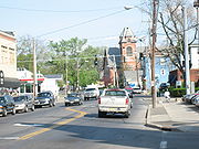
The highway becomes Main Street in Owego
Owego (village), New York
Owego is a village in and the county seat of Tioga County, New York, USA. The population was 3,911 at the 2000 census. It is part of the Binghamton Metropolitan Statistical Area...
, entering the village near the fairgrounds. At the village's main square, NY 17C meets NY 96
New York State Route 96
New York State Route 96 is a northwest–southeast state highway in the Finger Lakes region of New York in the United States. The southern terminus of the route is at an interchange with NY 17 in the Southern Tier village of Owego, Tioga County. Its northern terminus is at a junction with...
. The two routes form a concurrency
Concurrency (road)
A concurrency, overlap, or coincidence in a road network is an instance of one physical road bearing two or more different highway, motorway, or other route numbers...
for a short distance along the one-way sections of Court Street (westbound) and Park Street (eastbound) around the Tioga County Courthouse before splitting at Front Street. NY 96 continues across the Susquehanna River to access NY 17 and NY 434
New York State Route 434
New York State Route 434 is a state highway located in the Southern Tier of the U.S. state of New York. The route extends for from an intersection with NY 96 in the village of Owego to an intersection with US 11 in the city of Binghamton. In between, NY 434 passes through the...
while NY 17C continues east on Front Street through an old residential area. This was where the original Route 17C started, as pre-expressway Route 17 followed Route 96 to a routing (now NY 434) across the river.
In the eastern part of the village, NY 17C breaks from Front Street and continues straight onto Fifth Avenue, following the north bank of the river as it progresses. The highway between the Front Street/Fifth Avenue intersection and the NY 17
New York State Route 17
New York State Route 17 is a state highway that extends for through the Southern Tier and Downstate regions of New York in the United States...
access road near Hickories Park is well-developed with retail establishments.
For the next several miles, the highway runs alongside the Norfolk Southern Railway
Norfolk Southern Railway
The Norfolk Southern Railway is a Class I railroad in the United States, owned by the Norfolk Southern Corporation. With headquarters in Norfolk, Virginia, the company operates 21,500 route miles in 22 eastern states, the District of Columbia and the province of Ontario, Canada...
tracks, which separate it from the north bank of the river. Near Campville, the highway serves as the northern terminus of NY 962J
New York State Route 962J
New York State Route 962J is a northeast–southwest reference route that has been erroneously signed as a touring route in Southern Tier town of Owego in Tioga County, New York...
, a short reference route traversing the Susquehanna River
Susquehanna River
The Susquehanna River is a river located in the northeastern United States. At long, it is the longest river on the American east coast that drains into the Atlantic Ocean, and with its watershed it is the 16th largest river in the United States, and the longest river in the continental United...
. Although most reference routes are unsigned, NY 962J is one of four within the state that is erroneously signed as a touring route. The route, a connector between Campville and Apalachin
Apalachin, New York
Apalachin is a census-designated place within the Town of Owego in Tioga County, New York, United States. The population was 1,126 in the 2000 census. It is named after the Apalachin Creek. Apalachin means From where the messenger returned in the Lenape.Apalachin is in the southeast part of the...
over the Susquehanna that opened in 2001, is known locally as the "Millennium Bridge".
Broome County
After passing through Campville, the highway crosses into Broome County, then enters EndicottEndicott, New York
Endicott is a village in Broome County, New York, United States. The population was 13,038 at the 2000 census. It is part of the Binghamton Metropolitan Statistical Area. The village is named after Henry B...
as West Main Street, near the En-Joie Golf Course, former site of the PGA's annual B.C. Open
B.C. Open
The Dick's Sporting Goods Open is a Champions Tour event. It debuted in July 2007, supplanting the B.C. Open, a now-defunct PGA Tour event, which was held annually from 1971 to 2006. It is sponsored by Dick's Sporting Goods....
until 2005. This section has been rebuilt within the last few years. Further along its path, 17C runs concurrently
Concurrency (road)
A concurrency, overlap, or coincidence in a road network is an instance of one physical road bearing two or more different highway, motorway, or other route numbers...
with NY 26
New York State Route 26
New York State Route 26 is a north–south state highway that runs for through Central New York in the United States. Its southern terminus is located at the Pennsylvania state line south of the town of Vestal in Broome County, where it becomes Pennsylvania Route 267...
for approximately one mile in the village between Nanticoke/Exchange Avenues and McKinley Avenue before Route 26 continues to the south. West Main Street becomes East Main Street east of Nanticoke Avenue.
Between Endicott and Johnson City
Johnson City, New York
Johnson City is a village in Broome County, New York, United States. The population was 15,535 at the 2000 census. It is part of the Binghamton Metropolitan Statistical Area....
, NY 17C is split into one-way sections, with each serving as a frontage road for the expressway. While in this configuration, NY 17C is known as the George F. Highway.
Binghamton, New York
Binghamton is a city in the Southern Tier of New York in the United States. It is near the Pennsylvania border, in a bowl-shaped valley at the confluence of the Susquehanna and Chenango Rivers...
. There are arches over the highway at either end of Johnson City commemorating the village's role as home to the former Endicott-Johnson Shoe Corporation
Endicott Johnson Corporation
The Endicott-Johnson Shoe Company was a prosperous manufacturer of shoes based in New York's Southern Tier, with factories mostly located in the area's Triple Cities of Binghamton, Johnson City, and Endicott...
.
NY 17C ends at U.S. Route 11 in Binghamton, just west of the Chenango River
Chenango River
The Chenango River is a tributary of the Susquehanna River in central New York in the United States. It drains a dissected plateau area in upstate New York at the northern end of the Susquehanna watershed....
. Main Street, however, continues east for an additional 80 yards (73.2 m) to the Court Street Bridge
Court Street Bridge (Binghamton)
The Court Street Bridge is a combined motor vehicle and pedestrian crossing which spans the Chenango River in the New York State city of Binghamton...
as part of US 11.
History
The section of what is now NY 17C between WaverlyWaverly, Tioga County, New York
----Waverly is the largest village in Tioga County, New York, United States. It is located southeast of Elmira in the Southern Tier region. This village was incorporated as the southwest part of the town of Barton in 1854...
and Owego
Owego (village), New York
Owego is a village in and the county seat of Tioga County, New York, USA. The population was 3,911 at the 2000 census. It is part of the Binghamton Metropolitan Statistical Area...
was originally designated as part of Route 4, an unsigned legislative route
Legislative route
In United States, a legislative route or legislative highway is a highway defined by laws passed in a state legislature. The numbering of such highways may or may not correspond to the numbers familiar to the public as part of the state, U.S. highway, and Interstate highway systems...
, by the New York State Legislature in 1908. When the first set of posted routes in New York
New York
New York is a state in the Northeastern region of the United States. It is the nation's third most populous state. New York is bordered by New Jersey and Pennsylvania to the south, and by Connecticut, Massachusetts and Vermont to the east...
were assigned in 1924, most of legislative Route 4—including from Waverly to Owego—became part of NY 17
New York State Route 17
New York State Route 17 is a state highway that extends for through the Southern Tier and Downstate regions of New York in the United States...
. In the 1930 renumbering of state highways in New York, NY 17 was left as-is from Waverly to Owego while NY 17C was assigned to the portion of its current alignment east of Owego.
On January 1, 1970, NY 17 was officially rerouted onto the new Southern Tier Expressway (STE) between Waverly and Vestal
Vestal, New York
Vestal is a town within Broome County in the Southern Tier of New York, and lies between the Susquehanna River and the Pennsylvania border. As of the 2000 census, the population was 26,535, estimated to have grown to 27,369 in 2009....
even though the section of the freeway between Waverly and Nichols
Nichols (village), New York
Nichols is a village located in the Town of Nichols in Tioga County, New York, USA. The population was 574 at the 2000 census. It is part of the Binghamton Metropolitan Statistical Area. The name is that of a local benefactor, Colonel Nichols....
had yet to be completed. In actuality, NY 17 continued to follow its original surface alignment from Waverly to Nichols, where it used a portion of NY 282
New York State Route 282
New York State Route 282 is a state highway in the Southern Tier of New York in the United States. This highway is a north–south roadway connecting NY 17C to the Pennsylvania state line, where it becomes Pennsylvania Route 187.NY 282 is located entirely within Tioga...
to reach the freeway. The former surface routing of NY 17 from Nichols to Owego became part of an extended NY 17C ca. 1971. The Waverly–Nichols segment of the STE was completed ca. 1974, at which time NY 17 was realigned to follow the freeway while NY 17C was extended west over NY 17's former alignment to Waverly.