

Sloatsburg, New York
Encyclopedia
Sloatsburg is a village in the town of Ramapo
in Rockland County
, New York
, United States
. It is located east of Orange County, New York
and sits at the southern entrance to Harriman State Park. The population was 3,117 at the 2000 census. The village is named after Stephen Sloat, an early landowner.
, it was headquarters for American troops stationed in the Ramapo Pass
. The house is a private residence, listed on the National Register of Historic Places.
The land that would become the village of Sloatsburg was part of the hunting grounds of the Minsi tribe of the Leni Lenape Indians. The area was also the site of a major Indian path through the Ramapo Mountains
. The path would subsequently become the New York to Albany road and, in 1800, the Orange Turnpike; it remains an important thoroughfare today—the New York State Thruway
, New York Route 17 and the Norfolk Southern Railway
line run along its route. Wynant Van Gelder purchased the area from the Minsi in 1738, and in 1747, gave it to his father-in-law, Isaac Van Deusen. Stephen Sloat married Marritje Van Deusen and was given the land in 1763. There he established Sloat's Tavern, which became a regular stop on the New York to Albany stage route.
During the American Revolutionary War
the stage route became an important military route and the Ramapo pass an important strategic point, occupied by American troops throughout the war. George Washington
travelled through the area several times and stayed in Sloat's Tavern at least once, on June 6, 1779. After the war, the Sloats added a tannery and a cotton mill, which continued in operation by the family until the American Civil War
, when it closed due to a lack of cotton. In the early 19th century, Abram Dater built a forge on the Ramapo River
, and a grist mill and a saw mill soon followed.
Between 1836 and 1841, the Erie Railroad
built a line through Sloatsburg, resulting in a major increase in the population and prosperity of the village. After the Civil War the village prospered until the great flood of 1903 destroyed most of the factories in the town, many of which were never rebuilt.
Due to its position astride the Orange Turnpike, the rise of the automobile early in the 20th century had a profound impact on the area—prior to the construction of the New York State Thruway and the Palisades Parkway in the 1950s, Sloatsburg was cut in half by automobile traffic, which could back up for miles in the forties and fifties. Over the Fourth of July weekend in 1952, the backup extended for eight miles. During prohibition
, Sloatsburg's rural setting and proximity to New York City
made it an attractive location for stills and bootlegging; the gangsters running the operations also occasionally used the local woods to dispose of bodies of those killed in the course of business. In 1929, with a population of 1,559, Sloatsburg was incorporated as a village, with David Henion elected as the first mayor.
According to the United States Census Bureau
, the village has a total area of 2.7 square miles (7 km²), of which, 2.7 square miles (7 km²) of it is land and 0.04 square mile (0.1035995244 km²) of it (1.11%) is water.
The western part of the village borders Orange County
.
of 2000, there were 3,117 people, 1,046 households, and 826 families residing in the village. The population density
was 1,162.0 people per square mile (449.1/km2). There were 1,078 housing units at an average density of 401.9 per square mile (155.3/km2). The racial makeup of the village was 90.95% White, 3.53% African American, 0.45% Native American, 2.50% Asian, 0.10% Pacific Islander, 0.93% from other races
, and 1.54% from two or more races. Hispanic or Latino of any race were 5.58% of the population.
There were 1,046 households out of which 38.5% had children under the age of 18 living with them, 63.6% were married couples
living together, 10.4% had a female householder with no husband present, and 21.0% were non-families. 15.9% of all households were made up of individuals and 5.7% had someone living alone who was 65 years of age or older. The average household size was 2.91 and the average family size was 3.27.
In the village the population was spread out with 26.1% under the age of 18, 7.0% from 18 to 24, 31.1% from 25 to 44, 24.2% from 45 to 64, and 11.6% who were 65 years of age or older. The median age was 37 years. For every 100 females there were 99.6 males. For every 100 females age 18 and over, there were 93.3 males.
The median income for a household in the village was $70,721, and the median income for a family was $78,529. Males had a median income of $51,549 versus $39,464 for females. The per capita income
for the village was $27,180. About 0.8% of families and 3.0% of the population were below the poverty line, including 1.5% of those under age 18 and 3.4% of those age 65 or over.
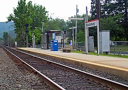 Sloatsburg station
serves Metro North
train service on the Port Jervis Line to Hoboken
- where connecting PATH
train service is available to New York
and Jersey City, and Secaucus
- the connecting point to New York Penn Station and points in New Jersey
. Going the other way, the line goes to Port Jervis
as well. Sloatsburg is also the western terminus for Transport of Rockland
's bus line number 93.
New York State Route 17
travels through Sloatsburg as Orange Turnpike. Interstate 87
also travels through Sloatsburg, but there is no direct access from Interstate 87 to other roads in Sloatsburg. It is possible to enter the I-87 rest area through Waldron Terrace off of Seven Lakes Drive and transfer onto I-87. Seven Lakes Drive
also serves Sloatsburg as well.
. There are some other sites of historical interest in the village.
Bartlett, Ted, Historic Structure Report for Harmony Hall/Jacob Sloat House, Crawford & Stearns Architects and Preservation Planners, 2008.
Ramapo, New York
Ramapo , formerly known as New Hempstead and then Hampstead, is a town in Rockland County, New York, United States located north of New Jersey; southeast of Orange County, New York; south of the Town of Haverstraw and west of the Town of Clarkstown and the Town of Orangetown...
in Rockland County
Rockland County, New York
Rockland County is a suburban county 15 miles to the northwest of Manhattan and part of the New York City Metropolitan Area, in the U.S. state of New York. It is the southernmost county in New York west of the Hudson River, and the smallest county in New York outside of New York City. The...
, New York
New York
New York is a state in the Northeastern region of the United States. It is the nation's third most populous state. New York is bordered by New Jersey and Pennsylvania to the south, and by Connecticut, Massachusetts and Vermont to the east...
, United States
United States
The United States of America is a federal constitutional republic comprising fifty states and a federal district...
. It is located east of Orange County, New York
Orange County, New York
Orange County is a county located in the U.S. state of New York. It is part of the Poughkeepsie–Newburgh–Middletown, NY Metropolitan Statistical Area and is located at the northern reaches of the New York metropolitan area. The county sits in the state's scenic Mid-Hudson Region of the Hudson Valley...
and sits at the southern entrance to Harriman State Park. The population was 3,117 at the 2000 census. The village is named after Stephen Sloat, an early landowner.
History
Sloatsburg, originally Pothat, is named after the Sloat family, having settled in area about 1760. Jacob Sloat, a mechanical genius, opened a mill in 1815 for making cotton cloth. He successfully turned to making exclusively cotton twine after patenting a process for dressing it in 1840. At peak, he produced around 8,000 lbs. per week. The mill ceased operations in 1878. The original Sloat stone house was a tavern, a regular stop on the New York to Albany stage route, and during the American RevolutionAmerican Revolution
The American Revolution was the political upheaval during the last half of the 18th century in which thirteen colonies in North America joined together to break free from the British Empire, combining to become the United States of America...
, it was headquarters for American troops stationed in the Ramapo Pass
Ramapo Mountains
The Ramapo Mountains are a forested chain of the Appalachian mountains in northeastern New Jersey and southeastern New York in the United States...
. The house is a private residence, listed on the National Register of Historic Places.
The land that would become the village of Sloatsburg was part of the hunting grounds of the Minsi tribe of the Leni Lenape Indians. The area was also the site of a major Indian path through the Ramapo Mountains
Ramapo Mountains
The Ramapo Mountains are a forested chain of the Appalachian mountains in northeastern New Jersey and southeastern New York in the United States...
. The path would subsequently become the New York to Albany road and, in 1800, the Orange Turnpike; it remains an important thoroughfare today—the New York State Thruway
New York State Thruway
The New York State Thruway is a system of limited-access highways located within the state of New York in the United States. The system, known officially as the Governor Thomas E. Dewey Thruway for former New York Governor Thomas E. Dewey, is operated by the New York State Thruway Authority and...
, New York Route 17 and the Norfolk Southern Railway
Norfolk Southern Railway
The Norfolk Southern Railway is a Class I railroad in the United States, owned by the Norfolk Southern Corporation. With headquarters in Norfolk, Virginia, the company operates 21,500 route miles in 22 eastern states, the District of Columbia and the province of Ontario, Canada...
line run along its route. Wynant Van Gelder purchased the area from the Minsi in 1738, and in 1747, gave it to his father-in-law, Isaac Van Deusen. Stephen Sloat married Marritje Van Deusen and was given the land in 1763. There he established Sloat's Tavern, which became a regular stop on the New York to Albany stage route.
During the American Revolutionary War
American Revolutionary War
The American Revolutionary War , the American War of Independence, or simply the Revolutionary War, began as a war between the Kingdom of Great Britain and thirteen British colonies in North America, and ended in a global war between several European great powers.The war was the result of the...
the stage route became an important military route and the Ramapo pass an important strategic point, occupied by American troops throughout the war. George Washington
George Washington
George Washington was the dominant military and political leader of the new United States of America from 1775 to 1799. He led the American victory over Great Britain in the American Revolutionary War as commander-in-chief of the Continental Army from 1775 to 1783, and presided over the writing of...
travelled through the area several times and stayed in Sloat's Tavern at least once, on June 6, 1779. After the war, the Sloats added a tannery and a cotton mill, which continued in operation by the family until the American Civil War
American Civil War
The American Civil War was a civil war fought in the United States of America. In response to the election of Abraham Lincoln as President of the United States, 11 southern slave states declared their secession from the United States and formed the Confederate States of America ; the other 25...
, when it closed due to a lack of cotton. In the early 19th century, Abram Dater built a forge on the Ramapo River
Ramapo River
The Ramapo River is a tributary of the Pompton River, approximately 30 mi long, in southern New York and northern New Jersey in the United States.-Course:...
, and a grist mill and a saw mill soon followed.
Between 1836 and 1841, the Erie Railroad
Erie Railroad
The Erie Railroad was a railroad that operated in New York State, New Jersey, Pennsylvania, Ohio, Indiana, and Illinois, originally connecting New York City with Lake Erie...
built a line through Sloatsburg, resulting in a major increase in the population and prosperity of the village. After the Civil War the village prospered until the great flood of 1903 destroyed most of the factories in the town, many of which were never rebuilt.
Due to its position astride the Orange Turnpike, the rise of the automobile early in the 20th century had a profound impact on the area—prior to the construction of the New York State Thruway and the Palisades Parkway in the 1950s, Sloatsburg was cut in half by automobile traffic, which could back up for miles in the forties and fifties. Over the Fourth of July weekend in 1952, the backup extended for eight miles. During prohibition
Prohibition
Prohibition of alcohol, often referred to simply as prohibition, is the practice of prohibiting the manufacture, transportation, import, export, sale, and consumption of alcohol and alcoholic beverages. The term can also apply to the periods in the histories of the countries during which the...
, Sloatsburg's rural setting and proximity to New York City
New York City
New York is the most populous city in the United States and the center of the New York Metropolitan Area, one of the most populous metropolitan areas in the world. New York exerts a significant impact upon global commerce, finance, media, art, fashion, research, technology, education, and...
made it an attractive location for stills and bootlegging; the gangsters running the operations also occasionally used the local woods to dispose of bodies of those killed in the course of business. In 1929, with a population of 1,559, Sloatsburg was incorporated as a village, with David Henion elected as the first mayor.
Geography
Sloatsburg is located at 41.161894°N 74.187707°W.According to the United States Census Bureau
United States Census Bureau
The United States Census Bureau is the government agency that is responsible for the United States Census. It also gathers other national demographic and economic data...
, the village has a total area of 2.7 square miles (7 km²), of which, 2.7 square miles (7 km²) of it is land and 0.04 square mile (0.1035995244 km²) of it (1.11%) is water.
The western part of the village borders Orange County
Orange County, New York
Orange County is a county located in the U.S. state of New York. It is part of the Poughkeepsie–Newburgh–Middletown, NY Metropolitan Statistical Area and is located at the northern reaches of the New York metropolitan area. The county sits in the state's scenic Mid-Hudson Region of the Hudson Valley...
.
Demographics
As of the censusCensus
A census is the procedure of systematically acquiring and recording information about the members of a given population. It is a regularly occurring and official count of a particular population. The term is used mostly in connection with national population and housing censuses; other common...
of 2000, there were 3,117 people, 1,046 households, and 826 families residing in the village. The population density
Population density
Population density is a measurement of population per unit area or unit volume. It is frequently applied to living organisms, and particularly to humans...
was 1,162.0 people per square mile (449.1/km2). There were 1,078 housing units at an average density of 401.9 per square mile (155.3/km2). The racial makeup of the village was 90.95% White, 3.53% African American, 0.45% Native American, 2.50% Asian, 0.10% Pacific Islander, 0.93% from other races
Race (United States Census)
Race and ethnicity in the United States Census, as defined by the Federal Office of Management and Budget and the United States Census Bureau, are self-identification data items in which residents choose the race or races with which they most closely identify, and indicate whether or not they are...
, and 1.54% from two or more races. Hispanic or Latino of any race were 5.58% of the population.
There were 1,046 households out of which 38.5% had children under the age of 18 living with them, 63.6% were married couples
Marriage
Marriage is a social union or legal contract between people that creates kinship. It is an institution in which interpersonal relationships, usually intimate and sexual, are acknowledged in a variety of ways, depending on the culture or subculture in which it is found...
living together, 10.4% had a female householder with no husband present, and 21.0% were non-families. 15.9% of all households were made up of individuals and 5.7% had someone living alone who was 65 years of age or older. The average household size was 2.91 and the average family size was 3.27.
In the village the population was spread out with 26.1% under the age of 18, 7.0% from 18 to 24, 31.1% from 25 to 44, 24.2% from 45 to 64, and 11.6% who were 65 years of age or older. The median age was 37 years. For every 100 females there were 99.6 males. For every 100 females age 18 and over, there were 93.3 males.
The median income for a household in the village was $70,721, and the median income for a family was $78,529. Males had a median income of $51,549 versus $39,464 for females. The per capita income
Per capita income
Per capita income or income per person is a measure of mean income within an economic aggregate, such as a country or city. It is calculated by taking a measure of all sources of income in the aggregate and dividing it by the total population...
for the village was $27,180. About 0.8% of families and 3.0% of the population were below the poverty line, including 1.5% of those under age 18 and 3.4% of those age 65 or over.
Transportation
Sloatsburg (Metro-North station)
The Sloatsburg Metro-North station serves the residents of Sloatsburg, New York, via Port Jervis Line commuter trains to New York City via Hoboken, away, and Secaucus Junction. The estimated travel time to Hoboken Terminal is about 50 minutes on express trains. It is the least-developed station...
serves Metro North
Metro north
Metro North can refer to either of* Metro-North Railroad, a commuter railroad serving parts of New York and Connecticut in the United States* Dublin Metro#Metro North, a branch of the proposed Dublin Metro, in Dublin, Ireland...
train service on the Port Jervis Line to Hoboken
Hoboken Terminal
Hoboken Terminal is one of the New York Metropolitan area's major transportation hubs. The commuter-oriented intermodal facility, is located on the Hudson River in Hoboken, New Jersey...
- where connecting PATH
Port Authority Trans-Hudson
PATH, derived from Port Authority Trans-Hudson, is a rapid transit railroad linking Manhattan, New York City with Newark, Harrison, Hoboken and Jersey City in metropolitan northern New Jersey...
train service is available to New York
New York
New York is a state in the Northeastern region of the United States. It is the nation's third most populous state. New York is bordered by New Jersey and Pennsylvania to the south, and by Connecticut, Massachusetts and Vermont to the east...
and Jersey City, and Secaucus
Secaucus Junction
The Frank R. Lautenberg Secaucus Junction Station is a major commuter rail hub in Secaucus, New Jersey...
- the connecting point to New York Penn Station and points in New Jersey
New Jersey
New Jersey is a state in the Northeastern and Middle Atlantic regions of the United States. , its population was 8,791,894. It is bordered on the north and east by the state of New York, on the southeast and south by the Atlantic Ocean, on the west by Pennsylvania and on the southwest by Delaware...
. Going the other way, the line goes to Port Jervis
Port Jervis (Metro-North station)
The Port Jervis Metro-North station serves the residents of that city and surrounding communities. It is the western terminus of the Port Jervis Line, with trains taking New York City-bound passengers there via Hoboken and Secaucus Junction...
as well. Sloatsburg is also the western terminus for Transport of Rockland
Transport of Rockland
The Transport of Rockland is the bus system for Rockland County, New York, providing service along major routes in Rockland County, as well as connections to Clarkstown Mini-Trans in Clarkstown, Spring Valley Jitney in Spring Valley, the Bee-Line Bus System in Westchester as well as connections to...
's bus line number 93.
New York State Route 17
New York State Route 17
New York State Route 17 is a state highway that extends for through the Southern Tier and Downstate regions of New York in the United States...
travels through Sloatsburg as Orange Turnpike. Interstate 87
Interstate 87
Interstate 87 is a Interstate Highway located entirely within New York State in the United States of America. I-87 is the longest intrastate Interstate highway in the Interstate Highway System. Its southern end is at the Bronx approaches of the Robert F. Kennedy Bridge in New York City...
also travels through Sloatsburg, but there is no direct access from Interstate 87 to other roads in Sloatsburg. It is possible to enter the I-87 rest area through Waldron Terrace off of Seven Lakes Drive and transfer onto I-87. Seven Lakes Drive
Seven Lakes Drive
Seven Lakes Drive is a 17.91 mile long parkway in the U.S. state of New York. The southern terminus of the route is at New York State Route 17 in Sloatsburg. The northern terminus is at U.S. Route 9W and U.S. Route 202 a mile south of Fort Montgomery in Bear Mountain State Park...
also serves Sloatsburg as well.
Famous natives and residents
- Garry Bakker - A right-handed pitcher, he was selected in the 2007 Rule 5 DraftRule 5 draftThe Rule 5 draft is a Major League Baseball player draft that occurs each year in December, at the annual Winter Meeting of general managers. The Rule 5 draft aims to prevent teams from stockpiling too many young players on their minor league affiliate teams when other teams would be willing to...
by the New York MetsNew York MetsThe New York Mets are a professional baseball team based in the borough of Queens in New York City, New York. They belong to Major League Baseball's National League East Division. One of baseball's first expansion teams, the Mets were founded in 1962 to replace New York's departed National League...
and assigned to their Pacific Coast LeaguePacific Coast LeagueThe Pacific Coast League is a minor-league baseball league operating in the Western, Midwestern and Southeastern United States. Along with the International League and the Mexican League, it is one of three leagues playing at the Triple-A level, which is one step below Major League Baseball.The...
Triple-AAAA (baseball)Triple-A refers to the highest level of play in minor league baseball in the United States and Mexico.-Purpose:Triple-A teams' main purpose is to prepare players for the Major Leagues:...
affiliate, the New Orleans ZephyrsNew Orleans ZephyrsThe New Orleans Zephyrs are a minor league baseball team based in Metairie, Louisiana, a suburb of New Orleans. The Zephyrs play in the Pacific Coast League and are the Triple-A affiliate of the Miami Marlins. The Zephyrs play their home games at Zephyr Field....
, after pitching for four seasons in the Chicago White SoxChicago White SoxThe Chicago White Sox are a Major League Baseball team located in Chicago, Illinois.The White Sox play in the American League's Central Division. Since , the White Sox have played in U.S. Cellular Field, which was originally called New Comiskey Park and nicknamed The Cell by local fans...
organization. - Bryan Hoch - Sportswriter covering the New York YankeesNew York YankeesThe New York Yankees are a professional baseball team based in the The Bronx, New York. They compete in Major League Baseball in the American League's East Division...
. - Scott Wright - is an American professional wrestler and bodybuilder, better known by his ring name Scotty Charisma. He currently performs on the independent circuit as Mr. Scott Wright
Historical landmarks
Four properties in Sloatsburg, all associated with the Sloat family, have been listed on the National Register of Historic PlacesNational Register of Historic Places
The National Register of Historic Places is the United States government's official list of districts, sites, buildings, structures, and objects deemed worthy of preservation...
. There are some other sites of historical interest in the village.
- The Glenwood Hotel, est. 1908, was owned and operated by Henry and Kathleen Tobin. For 50 years its elegant open-air dining rooms were a favorite dinner stop for many travelers en-route to upstate New York, Vermont, and Canada, prior to the opening of the New York State Thruway. Wealthy patrons from nearby Tuxedo Park were also regulars at the Glenwood. The upper floors operated as a boarding house for workers in the mills of Sloatsburg until 1950. In 1998, the building was preserved and restored to its original appearance.
- Old Sloatsburg CemeteryOld Sloatsburg CemeteryThe Old Sloatsburg Cemetery is located at the end of Richard Street in Sloatsburg, New York, United States. It began as the Sloat family cemetery with the burial of Revolutionary War casualty John Sloat in 1781...
- off Eagle Valley Road - 1700 gravesites, 1400 marked with headstones, earliest burial Private John Sloat 1781, during Revolutionary War. A settlement-era burial ground associated with the development of the community of Sloatsburg including the Sloat Family Burial Ground, founders of the Village. (NRHP) - Sloatsburg Historical Society - Native American artifacts display.
- Sloatsburg Public Library, 1 Liberty Rock Road - Permanent exhibit of artifacts excavated from the Spring House Rock Shelter in Sloatsburg. Artifacts date back to thousands of years.
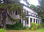
- Sloat HouseSloat HouseThe Sloat House is located at the corner of NY 17 and Sterling Avenue in Sloatsburg, New York, United States. It is a stone house, dating to the mid-18th century, with a frame front addition built in the 1810s....
& Inn, 19 Orange Turnpike (Route 17). A stone house dating back to the mid-18th century with a frame-front edition built in the 1810s. It served as a meeting place for local politicians and officials during the Revolution, and was home to Sloat family members for many years, for whom the village is named. (NRHP) - Sloat's Dam and Mill PondSloat's Dam and Mill PondSloat's Dam and Mill Pond is located between Waldron Terrace and Ballard Avenue in Sloatsburg, New York, United States. The 200-foot–long concrete dam creates the mill pond north of it by impounding the Ramapo River....
, in Eleanor Burlingham Memorial Park off Waldron Terrace. Only remaining dam on this stretch of the Ramapo RiverRamapo RiverThe Ramapo River is a tributary of the Pompton River, approximately 30 mi long, in southern New York and northern New Jersey in the United States.-Course:...
, originally built by Isaac Sloat in 1792. (NRHP) - Jacob Sloat HouseJacob Sloat HouseThe Jacob Sloat House, originally called Harmony Hall, is located on Liberty Rock Road in Sloatsburg, New York, United States. Built in the late 1840s, it is a wooden house that shows the transition from the waning Greek Revival style to the newer Picturesque and Italianate modes.It was built late...
, (Harmony Hall) 15 Liberty Rock Road. 1848 mansion transitions from Greek RevivalGreek Revival architectureThe Greek Revival was an architectural movement of the late 18th and early 19th centuries, predominantly in Northern Europe and the United States. A product of Hellenism, it may be looked upon as the last phase in the development of Neoclassical architecture...
to PicturesquePicturesquePicturesque is an aesthetic ideal introduced into English cultural debate in 1782 by William Gilpin in Observations on the River Wye, and Several Parts of South Wales, etc. Relative Chiefly to Picturesque Beauty; made in the Summer of the Year 1770, a practical book which instructed England's...
. Possibly co-designed by Sloat's friend, painter and occasional architect Jasper Cropsey. The Town of Ramapo and Friends of Harmony Hall-Jacob Sloat House have been working together since 2006 to restore the mansion for future use as a regional cultural center. It is estimated that as much as 95 percent of the 1848 footprint of the house has survived. Harmony Hall was listed to the State and National Register of Historic Places in 2006. (NRHP)
Sources
Kuykendall, Eugene L., Historic Sloatsburg, 1738-1998, The Way it Was, Is and Can Be, Sloatsburg Historical Society, 1998.Bartlett, Ted, Historic Structure Report for Harmony Hall/Jacob Sloat House, Crawford & Stearns Architects and Preservation Planners, 2008.