
New York State Route 417
Encyclopedia
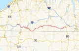
New York State Route 417 (NY 417) is an east–west state highway
located in the Southern Tier
of New York
in the United States. It begins at exit 20 of the Southern Tier Expressway (Interstate 86
or I-86 and NY 17
) in the city of Salamanca
and ends at a junction with NY 415
in Painted Post
, west of the city of Corning
. At 105.25 miles (169.38 km) in length, NY 417 is the longest of the state highways that were formerly part of NY 17 before the construction of the Southern Tier Expressway. It also diverges the most from the current NY 17, coming within 100 feet (30 m) of the Pennsylvania state line at one intersection.
In 1908, the New York State Legislature created Route 4, an unsigned legislative route
extending across the Southern Tier from Lake Erie
to the Hudson River
. The route followed most of what is now NY 417; however, from Olean to Wellsville
and from Andover
to Jasper
, it followed a more northerly alignment instead. Most of Route 4 became NY 17 in 1924, and NY 17 was realigned in 1930 to follow all of modern NY 417 between Salamanca and Corning. The highway remained part of NY 17 until the 1960s and 1970s, when NY 17 was moved onto the Southern Tier Expressway as sections of the new freeway opened to traffic.
On January 1, 1970, NY 417 was assigned to NY 17's former routing between Steamburg
and Salamanca. This section was closed to traffic soon afterward, but NY 417 was subsequently reassigned to NY 17's old alignment between Allegany
and Corning. The remainder of the expressway between Salamanca and Allegany was completed by the early 1990s, and NY 417 was extended west to cover the highway vacated by NY 17. On its east end, NY 417 originally overlapped with US 15 to meet NY 17 in Painted Post. It was altered in 1997 to directly serve Gang Mills
via Hamilton Street and extended into Painted Post in 2008.
and Steuben
counties is maintained by the New York State Department of Transportation
(NYSDOT). In Cattaraugus County
, maintenance of the route is split between NYSDOT and the cities of Olean and Salamanca
. All of NY 417 within Olean is city-maintained, save for one block of East State Street between NY 16
and Barry Street. To the west in Salamanca, the route is locally maintained from the junction of Clinton Street and Wildwood Avenue to the eastern city line. The Allegany Indian Reservation has jurisdiction over the portion of NY 417 that lies outside of the Salamanca city limits but within the reservation; however, this section is maintained by NYSDOT.
and NY 17
) in Salamanca
, a city wholly located within the Allegany Indian Reservation. It heads east as Broad Street, crossing through the city's business district and intersecting the south end of NY 353
and paralleling the Allegheny River
as it passes through the mostly residential central portion of the city. NY 417 changes names to Clinton Street after crossing Main Street, and subsequently intersects U.S. Route 219
(US 219) eight blocks later at Parkway Drive. US 219 joins
NY 417 here, and the two routes head northeast across a long bridge carrying Clinton Street across the Allegheny River. On the north bank, Clinton Street merges with Wildwood Avenue, at which point US 219 and NY 417 join the latter for five blocks to a junction with Central Avenue. US 219 leaves NY 417 here, following Central Avenue out of the city while NY 417 continues east as part of US 219 Business.
Not far to the east of US 219, US 219 Business and NY 417 leave Salamanca upon crossing over Great Valley Creek, which serves as the boundary between Salamanca and the town of Great Valley
. In Great Valley, the homes that had lined NY 417 gradually give way to forests and otherwise undeveloped areas as the highway turns south to follow the eastern edge of the Allegheny River valley. The river, the valley, and the road all turn back to the east in the adjacent town of Carrollton
, where US 219 Business leaves NY 417 to continue south toward Bradford, Pennsylvania
. NY 417 continues to follow the Allegheny River and the nearby Southern Tier Expressway (STE) through isolated areas to a point west of the village of Allegany
, where it indirectly intersects with I-86 and NY 17. From there, it passes through Allegany and serves the campus of St. Bonaventure University
before entering the city of Olean
, the largest community along its length.
In Olean, NY 417 initially follows State Street across a heavily commercialized area before entering a more residential portion of the city. It continues to run past a handful of smaller businesses to Olean's downtown district, where it meets NY 16
at Union Street. East of here, NY 417 diverges from the STE as it crosses over Olean Creek and follows the Allegheny River into the slightly less populated town of Portville
. The route continues for about 5 miles (8 km) to the village of Portville
, the site of a brief concurrency with NY 305
. NY 417's southeast heading continues east of the small village, taking the road away from the river and into Allegany County
.
, where NY 275
begins at NY 417 in the village center and heads north toward Friendship
.
NY 417, meanwhile, leaves Bolivar to the east, winding its way northeastward across the mountains of the Southern Tier
to its next large community, the village of Wellsville
. The route enters the community, located in the Genesee River
valley, from the west on Bolivar Road. It runs across the northwestern part of Wellsville and crosses the Genesee River before meeting NY 19
at a junction northwest of the village's center. NY 417 turns south here, following NY 19 along a four-lane divided highway
that runs along the Genesee River and bypasses much of the village's central business district. The highway and the overlap both end just southeast of downtown Wellsville, at which point NY 417 continues northeastward through the residential eastern section of the village on Andover Road.
About 2 miles (3.2 km) from the village center, the development along NY 417 ceases as the route progresses generally northeastward through the narrow valley of Dyke Creek, closely paralleling the main line
of the Western New York and Pennsylvania Railroad (WNYP). After another 7 miles (11 km), NY 417 comes to the village of Andover
, where NY 21
begins its long trip north toward the Finger Lakes
. The WNYP also heads north here to follow NY 21 to the city of Hornell
; however, NY 417 continues east along Dyer Creek for another 2 miles (3.2 km) to the Steuben County
line.
of the Dyer Creek valley, reaching an elevation of 2300 feet (701 m) above sea level at the Greenwood
hamlet of West Greenwood. The route descends into a ravine known as Cole Hollow shortly afterward, where it intersects NY 248
north of the hamlet of Greenwood. Past NY 248, the route winds its way through Woodward Hollow to the town of Jasper
and a junction with NY 36
, another major north–south route, at a junction west of the hamlet of Jasper. NY 36 overlaps with NY 417 to the outskirts of the community, at which point it splits from NY 417 and heads toward Hornell. NY 417, meanwhile continues southeast through Jasper and follows Tuscarora Creek toward Woodhull
.
Beyond Jasper, the road meanders through a valley surrounding Tuscarora Creek, heading generally eastward to a larger gully containing the Canisteo River
and the village of Addison
. Just north of the village center, the route crosses over the river and intersects Front Street, which once carried NY 17F and later NY 432 into the village. Outside of Addison, NY 417 follows the Canisteo River and the Norfolk Southern Railway
's Southern Tier Line
into the adjacent town of Erwin
, where it connects to the limited-access US 15
at an interchange northwest of the confluence
of the Canisteo and Tioga River
s. At this point, the railroad and NY 417 turn northeast to follow US 15 and the Tioga River into the hamlet of Gang Mills
, a western suburb of Corning
.
In Gang Mills, NY 417 crosses the Southern Tier Line on an overpass and connects to US 15 twice: once in the community itself and again northeast of Gang Mills at Robert Dann Drive. The route continues past Robert Dann Drive on South Hamilton Street, crossing over the Cohocton River
and reconnecting to the Southern Tier Expressway at exit 44, a complex semi-directional T interchange that also connects I-86 and NY 17 to US 15. From here, the route proceeds into the village of Painted Post
as North Hamilton Street, serving two blocks of mostly commercial properties before terminating at an intersection with NY 415
.
, by the New York State Legislature in 1908. Route 4, a cross-state highway that began near Lake Erie
in Chautauqua County
and ended near the Hudson River
in Orange County
, proceeded east from Salamanca
to Corning
via Olean
, Hinsdale
, Belvidere, Wellsville
, Andover
, Hornell
, Jasper
, and Addison
. Much of legislative Route 4 west of Harriman
—including all of the route between Salamanca and Corning—was designated as part of NY 17
when the first set of posted routes in New York
were assigned in 1924. NY 17 was realigned in the 1930 renumbering of state highways in New York to follow more southerly alignments from Olean to Wellsville (via Ceres) and from Andover to Jasper (via Greenwood
). As a result, NY 17 now followed the length of current NY 417 between Salamanca and Corning.
As sections of the Southern Tier Expressway (STE) were completed, NY 17 was moved onto the expressway and NY 417 was assigned to sections of NY 17's former surface routing, beginning with the piece between Steamburg
and Salamanca on January 1, 1970. Ironically, that first section was the first to be deleted entirely when part of the route through the Allegany Indian Reservation was closed to traffic in the early 1970s. Around the same time, NY 17 was relocated onto the mostly completed Southern Tier Expressway between Allegany
and Corning, allowing the NY 417 designation to be transferred to NY 17's former alignment between the two locations. A second section—from exit 20 on the STE to US 219
in Salamanca—was added to NY 417 in the early 1980s following the completion of the STE between exits 20 and 21. The two segments were linked in the early 1990s following the completion of the expressway in the vicinity of Salamanca.
Originally, NY 417 extended into Painted Post by way of a concurrency
with US 15. NY 417 joined the freeway in Erwin
(exit 2) and followed it north to exit 44 of the STE, where both NY 417 and US 15 ended. The overlap was eliminated sometime after 1989. On April 1, 1997, ownership and maintenance of Hamilton Street from the east end of NY 417 at US 15 exit 2 to US 15 exit 4 in Gang Mills
was transferred from the town of Erwin to the state of New York as part of a highway maintenance swap between Erwin, the state, and Steuben County
. The new state highway, part of US 15 and NY 17 prior to the construction of the US 15 freeway, became an extension of NY 417. In 2008, NY 417 was extended again to a new terminus at NY 415
in Painted Post
following the completion of the I-86 / US 15 interchange reconstruction project. This section of NY 417 also follows part of NY 17's pre-freeway alignment.
The portion of former NY 417 from Steamburg to Salamanca is now designated as NY 951T, an unsigned reference route. Although the physical roadway remains continuous, part of it is closed to traffic due to the potential for the Allegheny Reservoir
to flood and inundate part of the roadway. Due to this situation, NY 951T exists in two segments: a 0.47 mile (0.7563898 km) western portion extending east from NY 394
in Coldspring
and a 3.55 miles (5.71 km) eastern portion that originates at NY 417 in Salamanca
and continues west. The Seneca Nation
Allegany reservation governmental headquarters, along with the surrounding hamlet of Jimerson Town, lies on NY 951T.
State highway
State highway, state road or state route can refer to one of three related concepts, two of them related to a state or provincial government in a country that is divided into states or provinces :#A...
located in the Southern Tier
Southern Tier
The Southern Tier is a geographical term that refers to the counties of New York State west of the Catskill Mountains along the northern border of Pennsylvania. It is a loosely defined term that generally includes the counties that border Pennsylvania west of Delaware County inclusive...
of New York
New York
New York is a state in the Northeastern region of the United States. It is the nation's third most populous state. New York is bordered by New Jersey and Pennsylvania to the south, and by Connecticut, Massachusetts and Vermont to the east...
in the United States. It begins at exit 20 of the Southern Tier Expressway (Interstate 86
Interstate 86 (east)
Interstate 86 is an Interstate Highway that extends for through northwestern Pennsylvania and southern New York in the United States...
or I-86 and NY 17
New York State Route 17
New York State Route 17 is a state highway that extends for through the Southern Tier and Downstate regions of New York in the United States...
) in the city of Salamanca
Salamanca (city), New York
Salamanca is a city in Cattaraugus County, New York, United States, located inside the Allegany Indian Reservation. The population was 6,097 at the 2000 census.-Geography:...
and ends at a junction with NY 415
New York State Route 415
New York State Route 415 is a state highway located in Steuben County, New York, United States. It is a north–south trunk road that parallels in part, the Cohocton River, Interstate 86 and Interstate 390. The southern terminus of the route is at an intersection with NY 414 in...
in Painted Post
Painted Post, New York
Painted Post is a village in Steuben County, New York, United States. The village is in the town of Erwin, west of the city of Corning. The population was 1,842 at the 2000 census. The name comes from a painted and carved post found by explorers at the junction of three local rivers...
, west of the city of Corning
Corning (city), New York
Corning is a city in Steuben County, New York, United States, on the Chemung River. The population was 10,842 at the 2000 census. It is named for Erastus Corning, an Albany financier and railroad executive who was an investor in the company that developed the community.- Overview :The city of...
. At 105.25 miles (169.38 km) in length, NY 417 is the longest of the state highways that were formerly part of NY 17 before the construction of the Southern Tier Expressway. It also diverges the most from the current NY 17, coming within 100 feet (30 m) of the Pennsylvania state line at one intersection.
In 1908, the New York State Legislature created Route 4, an unsigned legislative route
Legislative route
In United States, a legislative route or legislative highway is a highway defined by laws passed in a state legislature. The numbering of such highways may or may not correspond to the numbers familiar to the public as part of the state, U.S. highway, and Interstate highway systems...
extending across the Southern Tier from Lake Erie
Lake Erie
Lake Erie is the fourth largest lake of the five Great Lakes in North America, and the tenth largest globally. It is the southernmost, shallowest, and smallest by volume of the Great Lakes and therefore also has the shortest average water residence time. It is bounded on the north by the...
to the Hudson River
Hudson River
The Hudson is a river that flows from north to south through eastern New York. The highest official source is at Lake Tear of the Clouds, on the slopes of Mount Marcy in the Adirondack Mountains. The river itself officially begins in Henderson Lake in Newcomb, New York...
. The route followed most of what is now NY 417; however, from Olean to Wellsville
Wellsville (village), New York
Wellsville is a Village in Allegany County of New York State. At the top of the Eastern Triple Continental Divide, in south-central wooded and rural Allegany County, it is the largest population and business center in a 30-mile radius. The population was 5,171 at the 2000 census...
and from Andover
Andover (village), New York
Andover is a village located in the Town of Andover in Allegany County, New York, USA. The population was 1,073 at the 2000 census. The name is derived from Andover, Vermont....
to Jasper
Jasper, New York
Jasper is a town located in Steuben County, New York. As of the 2000 census, the town had a total population of 1,270. The name is that of a military hero at Fort Moultrie, William Jasper....
, it followed a more northerly alignment instead. Most of Route 4 became NY 17 in 1924, and NY 17 was realigned in 1930 to follow all of modern NY 417 between Salamanca and Corning. The highway remained part of NY 17 until the 1960s and 1970s, when NY 17 was moved onto the Southern Tier Expressway as sections of the new freeway opened to traffic.
On January 1, 1970, NY 417 was assigned to NY 17's former routing between Steamburg
Steamburg, New York
Steamburg is a hamlet in the town of Coldspring in Cattaraugus County, New York, United States. The community is located at the eastern terminus of New York State Route 394, at I-86 exit 17. Also converging on the hamlet is New York State Reference Route 950A Steamburg is a hamlet in the town of...
and Salamanca. This section was closed to traffic soon afterward, but NY 417 was subsequently reassigned to NY 17's old alignment between Allegany
Allegany (village), New York
Allegany is a village in Cattaraugus County, New York, USA. The population was 1,883 at the 2000 census.The Village of Allegany is by the east town line of the Town of Allegany, west of the City of Olean.St...
and Corning. The remainder of the expressway between Salamanca and Allegany was completed by the early 1990s, and NY 417 was extended west to cover the highway vacated by NY 17. On its east end, NY 417 originally overlapped with US 15 to meet NY 17 in Painted Post. It was altered in 1997 to directly serve Gang Mills
Gang Mills, New York
Gang Mills is a hamlet in Steuben County, New York, United States. The population was 3,304 at the 2000 census.Gang Mills is in located in the town of Erwin, southwest of Corning.-Geography:...
via Hamilton Street and extended into Painted Post in 2008.
Route description
All of NY 417 in AlleganyAllegany County, New York
Allegany County is a county located in the U.S. state of New York. As of the 2010 census, the population was 48,946. Its name derives from a Delaware Indian word, applied by settlers of Western New York State to a trail that followed the Allegheny River. Its county seat is...
and Steuben
Steuben County, New York
Steuben County is a county located in the U.S. state of New York. As of the 2010 census, the population was 98,990. Its name is in honor of Baron von Steuben, a German general who fought on the American side in the American Revolutionary War, though it is not pronounced the same...
counties is maintained by the New York State Department of Transportation
New York State Department of Transportation
The New York State Department of Transportation is responsible for the development and operation of highways, railroads, mass transit systems, ports, waterways and aviation facilities in the U.S...
(NYSDOT). In Cattaraugus County
Cattaraugus County, New York
Cattaraugus County is a county located in the U.S. state of New York. As of the 2010 census, the population was 80,317. The county seat is Little Valley.-History:...
, maintenance of the route is split between NYSDOT and the cities of Olean and Salamanca
Salamanca (city), New York
Salamanca is a city in Cattaraugus County, New York, United States, located inside the Allegany Indian Reservation. The population was 6,097 at the 2000 census.-Geography:...
. All of NY 417 within Olean is city-maintained, save for one block of East State Street between NY 16
New York State Route 16
New York State Route 16 is a state highway in western New York, United States. It runs from the Pennsylvania state line, where it is one of the highest highways in the state in elevation, to downtown Buffalo. NY 16 is a major route through Erie County, despite the construction of the...
and Barry Street. To the west in Salamanca, the route is locally maintained from the junction of Clinton Street and Wildwood Avenue to the eastern city line. The Allegany Indian Reservation has jurisdiction over the portion of NY 417 that lies outside of the Salamanca city limits but within the reservation; however, this section is maintained by NYSDOT.
Cattaraugus County
NY 417 begins at an interchange with the Southern Tier Expressway (I-86Interstate 86 (east)
Interstate 86 is an Interstate Highway that extends for through northwestern Pennsylvania and southern New York in the United States...
and NY 17
New York State Route 17
New York State Route 17 is a state highway that extends for through the Southern Tier and Downstate regions of New York in the United States...
) in Salamanca
Salamanca (city), New York
Salamanca is a city in Cattaraugus County, New York, United States, located inside the Allegany Indian Reservation. The population was 6,097 at the 2000 census.-Geography:...
, a city wholly located within the Allegany Indian Reservation. It heads east as Broad Street, crossing through the city's business district and intersecting the south end of NY 353
New York State Route 353
New York State Route 353 is a north–south state highway located within Cattaraugus County, New York, in the United States. It extends for from an intersection with NY 417 in the city of Salamanca to a junction with U.S. Route 62 in the hamlet of Dayton...
and paralleling the Allegheny River
Allegheny River
The Allegheny River is a principal tributary of the Ohio River; it is located in the Eastern United States. The Allegheny River joins with the Monongahela River to form the Ohio River at the "Point" of Point State Park in Downtown Pittsburgh, Pennsylvania...
as it passes through the mostly residential central portion of the city. NY 417 changes names to Clinton Street after crossing Main Street, and subsequently intersects U.S. Route 219
U.S. Route 219 in New York
U.S. Route 219 is a part of the U.S. Highway System that runs from Rich Creek, Virginia, to West Seneca, New York. In the U.S. state of New York, US 219 extends from the Pennsylvania state line at Carrollton to an interchange with the New York State Thruway at exit 55 in West...
(US 219) eight blocks later at Parkway Drive. US 219 joins
Concurrency (road)
A concurrency, overlap, or coincidence in a road network is an instance of one physical road bearing two or more different highway, motorway, or other route numbers...
NY 417 here, and the two routes head northeast across a long bridge carrying Clinton Street across the Allegheny River. On the north bank, Clinton Street merges with Wildwood Avenue, at which point US 219 and NY 417 join the latter for five blocks to a junction with Central Avenue. US 219 leaves NY 417 here, following Central Avenue out of the city while NY 417 continues east as part of US 219 Business.
Not far to the east of US 219, US 219 Business and NY 417 leave Salamanca upon crossing over Great Valley Creek, which serves as the boundary between Salamanca and the town of Great Valley
Great Valley, New York
Great Valley is a town in Cattaraugus County, New York, United States. The population was 2,145 at the 2000 census. The town is named after its local geographical setting, a relative comparison of two tributaries of the Allegheny River.The Town of Great Valley is centrally located in the...
. In Great Valley, the homes that had lined NY 417 gradually give way to forests and otherwise undeveloped areas as the highway turns south to follow the eastern edge of the Allegheny River valley. The river, the valley, and the road all turn back to the east in the adjacent town of Carrollton
Carrollton, New York
Carrollton is a town in Cattaraugus County, New York, United States. The population was 1,410 at the 2000 census. The name comes from an early settler.The Town of Carrollton is on the south border of Cattaraugus County...
, where US 219 Business leaves NY 417 to continue south toward Bradford, Pennsylvania
Bradford, Pennsylvania
Bradford is a small city located in rural McKean County, Pennsylvania, in the United States 78 miles south of Buffalo, New York. Settled in 1823, Bradford was chartered as a city in 1879 and emerged as a wild oil boomtown in the Pennsylvanian oil rush in the late 19th century...
. NY 417 continues to follow the Allegheny River and the nearby Southern Tier Expressway (STE) through isolated areas to a point west of the village of Allegany
Allegany (village), New York
Allegany is a village in Cattaraugus County, New York, USA. The population was 1,883 at the 2000 census.The Village of Allegany is by the east town line of the Town of Allegany, west of the City of Olean.St...
, where it indirectly intersects with I-86 and NY 17. From there, it passes through Allegany and serves the campus of St. Bonaventure University
St. Bonaventure University
St. Bonaventure University is a private, Franciscan Catholic university, located in Allegany, Cattaraugus County, New York, United States. It has roughly 2,400 undergraduate and graduate students....
before entering the city of Olean
Olean, New York
Olean is a city in Cattaraugus County, New York, United States. Olean is the largest city in Cattaraugus County, and serves as the financial, business, transportation and entertainment center of the county. It is one of the principal cities of the Southern Tier region of New York.The city is...
, the largest community along its length.
In Olean, NY 417 initially follows State Street across a heavily commercialized area before entering a more residential portion of the city. It continues to run past a handful of smaller businesses to Olean's downtown district, where it meets NY 16
New York State Route 16
New York State Route 16 is a state highway in western New York, United States. It runs from the Pennsylvania state line, where it is one of the highest highways in the state in elevation, to downtown Buffalo. NY 16 is a major route through Erie County, despite the construction of the...
at Union Street. East of here, NY 417 diverges from the STE as it crosses over Olean Creek and follows the Allegheny River into the slightly less populated town of Portville
Portville (town), New York
Portville is a town in Cattaraugus County, New York, United States. The population was 3,952 at the 2000 census. The name is derived by the town's early role in shipping lumber and other items down river....
. The route continues for about 5 miles (8 km) to the village of Portville
Portville (village), New York
Portville is a village in Cattaraugus County, New York, USA. The population was 1,024 at the 2000 census. The Village of Portville is within the south part of the Town of Portville and southeast of Olean, New York.- History :...
, the site of a brief concurrency with NY 305
New York State Route 305
New York State Route 305 is a north–south route in the Southern Tier that runs from the Pennsylvania state line in Cattaraugus County to the hamlet of Belfast in Allegany County, where it ends at NY 19...
. NY 417's southeast heading continues east of the small village, taking the road away from the river and into Allegany County
Allegany County, New York
Allegany County is a county located in the U.S. state of New York. As of the 2010 census, the population was 48,946. Its name derives from a Delaware Indian word, applied by settlers of Western New York State to a trail that followed the Allegheny River. Its county seat is...
.
Allegany County
The first 2 miles (3.2 km) of NY 417 in Allegany County traverses isolated, undeveloped areas as it runs along the base of a large valley surrounding Oswayo Creek, a tributary of the Allegheny River. It continues to the small hamlet of Ceres, where NY 417 skirts the Pennsylvania state line closely enough to serve as the de facto northern end of Pennsylvania Route 44, which officially begins about 100 feet (30 m) to the south of the junction. From Ceres, it turns to the northeast, utilizing a smaller valley formed by the Little Genesee Creek, itself a branch of Oswayo Creek. The 7 miles (11 km) valley leads NY 417 to the village of BolivarBolivar (village), New York
Bolivar a village in Allegany County, New York, United States. The village is in the northwest part of the town of Bolivar and is east of Olean, New York. The population was 1,173 at the 2000 census...
, where NY 275
New York State Route 275
New York State Route 275 is a north–south state highway in Allegany County, New York, United States. It connects the village of Bolivar and NY 417 at its southern end with the hamlet of Friendship to the north, where it intersects the Southern Tier Expressway...
begins at NY 417 in the village center and heads north toward Friendship
Friendship, New York
Friendship is a town in Allegany County, New York, USA. The population was 1,927 at the 2000 census. The town's name was adopted to mark the resolution of earlier conflicts....
.
NY 417, meanwhile, leaves Bolivar to the east, winding its way northeastward across the mountains of the Southern Tier
Southern Tier
The Southern Tier is a geographical term that refers to the counties of New York State west of the Catskill Mountains along the northern border of Pennsylvania. It is a loosely defined term that generally includes the counties that border Pennsylvania west of Delaware County inclusive...
to its next large community, the village of Wellsville
Wellsville (village), New York
Wellsville is a Village in Allegany County of New York State. At the top of the Eastern Triple Continental Divide, in south-central wooded and rural Allegany County, it is the largest population and business center in a 30-mile radius. The population was 5,171 at the 2000 census...
. The route enters the community, located in the Genesee River
Genesee River
The Genesee River is a North American river flowing northward through the Twin Tiers of Pennsylvania and New York. The river provided the original power for the Rochester area's 19th century mills and still provides hydroelectric power for downtown Rochester....
valley, from the west on Bolivar Road. It runs across the northwestern part of Wellsville and crosses the Genesee River before meeting NY 19
New York State Route 19
New York State Route 19 is a north–south state highway in Western New York in the United States. It is the longest state highway in that region, and the only other one besides NY 14 to completely transect the state from the Pennsylvania state line to the shore of Lake Ontario...
at a junction northwest of the village's center. NY 417 turns south here, following NY 19 along a four-lane divided highway
Divided Highway
Divided Highway is a compilation album by American rock band The Doobie Brothers, released in 2003. . All tracks are taken from the albums Cycles and Brotherhood .-Track listing:...
that runs along the Genesee River and bypasses much of the village's central business district. The highway and the overlap both end just southeast of downtown Wellsville, at which point NY 417 continues northeastward through the residential eastern section of the village on Andover Road.
About 2 miles (3.2 km) from the village center, the development along NY 417 ceases as the route progresses generally northeastward through the narrow valley of Dyke Creek, closely paralleling the main line
Main line (railway)
The Mainline or Main line of a railway is a track that is used for through trains or is the principal artery of the system from which branch lines, yards, sidings and spurs are connected....
of the Western New York and Pennsylvania Railroad (WNYP). After another 7 miles (11 km), NY 417 comes to the village of Andover
Andover (village), New York
Andover is a village located in the Town of Andover in Allegany County, New York, USA. The population was 1,073 at the 2000 census. The name is derived from Andover, Vermont....
, where NY 21
New York State Route 21
New York State Route 21 is a state highway extending for through the western part of New York in the United States. The southern terminus of the route is at NY 417 in Andover. The northern terminus is at NY 104 in Williamson...
begins its long trip north toward the Finger Lakes
Finger Lakes
The Finger Lakes are a pattern of lakes in the west-central section of Upstate New York in the United States. They are a popular tourist destination. The lakes are long and thin , each oriented roughly on a north-south axis. The two longest, Cayuga Lake and Seneca Lake, are among the deepest in...
. The WNYP also heads north here to follow NY 21 to the city of Hornell
Hornell, New York
Hornell is a city in Steuben County, New York, United States. The population was 9,019 at the 2000 census. The city is named after the Hornell family, early settlers. Its current population has not yet been released by the new census....
; however, NY 417 continues east along Dyer Creek for another 2 miles (3.2 km) to the Steuben County
Steuben County, New York
Steuben County is a county located in the U.S. state of New York. As of the 2010 census, the population was 98,990. Its name is in honor of Baron von Steuben, a German general who fought on the American side in the American Revolutionary War, though it is not pronounced the same...
line.
Steuben County
In Steuben County, NY 417 begins to climb the headwallHeadwall
In physical geography and geology the headwall of a glacial cirque is its highest cliff.In civil engineering, a headwall is a small retaining wall placed at the outlet of a stormwater pipe or culvert....
of the Dyer Creek valley, reaching an elevation of 2300 feet (701 m) above sea level at the Greenwood
Greenwood, New York
Greenwood is a town in Steuben County, New York, United States. The population was 849 at the 2000 census.- History :A pioneer road was cut through the town in the 18th Century, but no settlers remained in the town....
hamlet of West Greenwood. The route descends into a ravine known as Cole Hollow shortly afterward, where it intersects NY 248
New York State Route 248
New York State Route 248 is a state highway in a remote part of the Southern Tier region of New York in the United States. The route, located close to the Pennsylvania state line, passes through Allegany and Steuben Counties...
north of the hamlet of Greenwood. Past NY 248, the route winds its way through Woodward Hollow to the town of Jasper
Jasper, New York
Jasper is a town located in Steuben County, New York. As of the 2000 census, the town had a total population of 1,270. The name is that of a military hero at Fort Moultrie, William Jasper....
and a junction with NY 36
New York State Route 36
New York State Route 36 is a north–south state highway in the western part of New York in the United States. The highway extends for from the Pennsylvania state line at Troupsburg, Steuben County northward to Ogden, Monroe County, where it ends at an intersection with NY 31...
, another major north–south route, at a junction west of the hamlet of Jasper. NY 36 overlaps with NY 417 to the outskirts of the community, at which point it splits from NY 417 and heads toward Hornell. NY 417, meanwhile continues southeast through Jasper and follows Tuscarora Creek toward Woodhull
Woodhull, New York
Woodhull is a town in Steuben County, New York, United States. The population was 1,524 at the 2000 census.The Town of Woodhull is in the south part of the county, west of Corning, NY.- History :The first settlers arrived around 1804...
.
Beyond Jasper, the road meanders through a valley surrounding Tuscarora Creek, heading generally eastward to a larger gully containing the Canisteo River
Canisteo River
The Canisteo River is a tributary of the Tioga River in western New York in the United States. It drains a dissected plateau, a portion of the northern Allegheny Plateau southwest of the Finger Lakes region, in the far northwestern reaches of the watershed of the Susquehanna River.It rises in the...
and the village of Addison
Addison (village), New York
Addison is a village in Steuben County, New York, United States. The population was 1,797 at the 2000 census. The village and the surrounding town are named after the author Joseph Addison....
. Just north of the village center, the route crosses over the river and intersects Front Street, which once carried NY 17F and later NY 432 into the village. Outside of Addison, NY 417 follows the Canisteo River and the Norfolk Southern Railway
Norfolk Southern Railway
The Norfolk Southern Railway is a Class I railroad in the United States, owned by the Norfolk Southern Corporation. With headquarters in Norfolk, Virginia, the company operates 21,500 route miles in 22 eastern states, the District of Columbia and the province of Ontario, Canada...
's Southern Tier Line
Southern Tier Line
The Southern Tier Line is a railroad line owned and operated by the Norfolk Southern Railway in the U.S. states of New York and Pennsylvania. The line runs from Suffern, New York northwest to Buffalo, New York mostly along a former Erie Railroad line. From Suffern to Sparrowbush along which...
into the adjacent town of Erwin
Erwin, New York
Erwin is a town in Steuben County, New York, United States. The population was 7,227 at the 2000 census. The name is that of an early settler, who became the first Town Supervisor....
, where it connects to the limited-access US 15
U.S. Route 15 in New York
U.S. Route 15 is a part of the U.S. Highway System that runs from Walterboro, South Carolina, to Painted Post, New York. In the U.S. state of New York, US 15 extends through the Southern Tier from the Pennsylvania state line at Lindley north to an interchange with the Southern Tier...
at an interchange northwest of the confluence
Confluence
Confluence, in geography, describes the meeting of two or more bodies of water.Confluence may also refer to:* Confluence , a property of term rewriting systems...
of the Canisteo and Tioga River
Tioga River (Chemung River)
The Tioga River is a tributary of the Chemung River, approximately long, in northern Pennsylvania and western New York in the United States...
s. At this point, the railroad and NY 417 turn northeast to follow US 15 and the Tioga River into the hamlet of Gang Mills
Gang Mills, New York
Gang Mills is a hamlet in Steuben County, New York, United States. The population was 3,304 at the 2000 census.Gang Mills is in located in the town of Erwin, southwest of Corning.-Geography:...
, a western suburb of Corning
Corning (city), New York
Corning is a city in Steuben County, New York, United States, on the Chemung River. The population was 10,842 at the 2000 census. It is named for Erastus Corning, an Albany financier and railroad executive who was an investor in the company that developed the community.- Overview :The city of...
.
In Gang Mills, NY 417 crosses the Southern Tier Line on an overpass and connects to US 15 twice: once in the community itself and again northeast of Gang Mills at Robert Dann Drive. The route continues past Robert Dann Drive on South Hamilton Street, crossing over the Cohocton River
Cohocton River
The Cohocton River is a tributary of the Chemung River in western New York in the United States. Via the Chemung River, it is part of the Susquehanna River watershed, flowing to Chesapeake Bay...
and reconnecting to the Southern Tier Expressway at exit 44, a complex semi-directional T interchange that also connects I-86 and NY 17 to US 15. From here, the route proceeds into the village of Painted Post
Painted Post, New York
Painted Post is a village in Steuben County, New York, United States. The village is in the town of Erwin, west of the city of Corning. The population was 1,842 at the 2000 census. The name comes from a painted and carved post found by explorers at the junction of three local rivers...
as North Hamilton Street, serving two blocks of mostly commercial properties before terminating at an intersection with NY 415
New York State Route 415
New York State Route 415 is a state highway located in Steuben County, New York, United States. It is a north–south trunk road that parallels in part, the Cohocton River, Interstate 86 and Interstate 390. The southern terminus of the route is at an intersection with NY 414 in...
.
History
Three sections of modern NY 417 were designated as part of Route 4, an unsigned legislative routeLegislative route
In United States, a legislative route or legislative highway is a highway defined by laws passed in a state legislature. The numbering of such highways may or may not correspond to the numbers familiar to the public as part of the state, U.S. highway, and Interstate highway systems...
, by the New York State Legislature in 1908. Route 4, a cross-state highway that began near Lake Erie
Lake Erie
Lake Erie is the fourth largest lake of the five Great Lakes in North America, and the tenth largest globally. It is the southernmost, shallowest, and smallest by volume of the Great Lakes and therefore also has the shortest average water residence time. It is bounded on the north by the...
in Chautauqua County
Chautauqua County, New York
-Major highways:* Interstate 86/New York State Route 17 * Interstate 90 * U.S. Route 20* U.S. Route 62* New York State Route 5* New York State Route 39* New York State Route 60* New York State Route 394...
and ended near the Hudson River
Hudson River
The Hudson is a river that flows from north to south through eastern New York. The highest official source is at Lake Tear of the Clouds, on the slopes of Mount Marcy in the Adirondack Mountains. The river itself officially begins in Henderson Lake in Newcomb, New York...
in Orange County
Orange County, New York
Orange County is a county located in the U.S. state of New York. It is part of the Poughkeepsie–Newburgh–Middletown, NY Metropolitan Statistical Area and is located at the northern reaches of the New York metropolitan area. The county sits in the state's scenic Mid-Hudson Region of the Hudson Valley...
, proceeded east from Salamanca
Salamanca (city), New York
Salamanca is a city in Cattaraugus County, New York, United States, located inside the Allegany Indian Reservation. The population was 6,097 at the 2000 census.-Geography:...
to Corning
Corning (city), New York
Corning is a city in Steuben County, New York, United States, on the Chemung River. The population was 10,842 at the 2000 census. It is named for Erastus Corning, an Albany financier and railroad executive who was an investor in the company that developed the community.- Overview :The city of...
via Olean
Olean, New York
Olean is a city in Cattaraugus County, New York, United States. Olean is the largest city in Cattaraugus County, and serves as the financial, business, transportation and entertainment center of the county. It is one of the principal cities of the Southern Tier region of New York.The city is...
, Hinsdale
Hinsdale, New York
Hinsdale is a town in Cattaraugus County, New York, United States. The population was 2,270 at the 2000 census. The town was named after another location: Hinsdale, New Hampshire....
, Belvidere, Wellsville
Wellsville (village), New York
Wellsville is a Village in Allegany County of New York State. At the top of the Eastern Triple Continental Divide, in south-central wooded and rural Allegany County, it is the largest population and business center in a 30-mile radius. The population was 5,171 at the 2000 census...
, Andover
Andover (village), New York
Andover is a village located in the Town of Andover in Allegany County, New York, USA. The population was 1,073 at the 2000 census. The name is derived from Andover, Vermont....
, Hornell
Hornell, New York
Hornell is a city in Steuben County, New York, United States. The population was 9,019 at the 2000 census. The city is named after the Hornell family, early settlers. Its current population has not yet been released by the new census....
, Jasper
Jasper, New York
Jasper is a town located in Steuben County, New York. As of the 2000 census, the town had a total population of 1,270. The name is that of a military hero at Fort Moultrie, William Jasper....
, and Addison
Addison (village), New York
Addison is a village in Steuben County, New York, United States. The population was 1,797 at the 2000 census. The village and the surrounding town are named after the author Joseph Addison....
. Much of legislative Route 4 west of Harriman
Harriman, New York
Harriman is a village in Orange County, New York, United States. The population was 2,252 at the 2000 census. It is part of the Poughkeepsie–Newburgh–Middletown, NY Metropolitan Statistical Area as well as the larger New York–Newark–Bridgeport, NY-NJ-CT-PA Combined...
—including all of the route between Salamanca and Corning—was designated as part of NY 17
New York State Route 17
New York State Route 17 is a state highway that extends for through the Southern Tier and Downstate regions of New York in the United States...
when the first set of posted routes in New York
New York
New York is a state in the Northeastern region of the United States. It is the nation's third most populous state. New York is bordered by New Jersey and Pennsylvania to the south, and by Connecticut, Massachusetts and Vermont to the east...
were assigned in 1924. NY 17 was realigned in the 1930 renumbering of state highways in New York to follow more southerly alignments from Olean to Wellsville (via Ceres) and from Andover to Jasper (via Greenwood
Greenwood, New York
Greenwood is a town in Steuben County, New York, United States. The population was 849 at the 2000 census.- History :A pioneer road was cut through the town in the 18th Century, but no settlers remained in the town....
). As a result, NY 17 now followed the length of current NY 417 between Salamanca and Corning.
As sections of the Southern Tier Expressway (STE) were completed, NY 17 was moved onto the expressway and NY 417 was assigned to sections of NY 17's former surface routing, beginning with the piece between Steamburg
Steamburg, New York
Steamburg is a hamlet in the town of Coldspring in Cattaraugus County, New York, United States. The community is located at the eastern terminus of New York State Route 394, at I-86 exit 17. Also converging on the hamlet is New York State Reference Route 950A Steamburg is a hamlet in the town of...
and Salamanca on January 1, 1970. Ironically, that first section was the first to be deleted entirely when part of the route through the Allegany Indian Reservation was closed to traffic in the early 1970s. Around the same time, NY 17 was relocated onto the mostly completed Southern Tier Expressway between Allegany
Allegany (village), New York
Allegany is a village in Cattaraugus County, New York, USA. The population was 1,883 at the 2000 census.The Village of Allegany is by the east town line of the Town of Allegany, west of the City of Olean.St...
and Corning, allowing the NY 417 designation to be transferred to NY 17's former alignment between the two locations. A second section—from exit 20 on the STE to US 219
U.S. Route 219 in New York
U.S. Route 219 is a part of the U.S. Highway System that runs from Rich Creek, Virginia, to West Seneca, New York. In the U.S. state of New York, US 219 extends from the Pennsylvania state line at Carrollton to an interchange with the New York State Thruway at exit 55 in West...
in Salamanca—was added to NY 417 in the early 1980s following the completion of the STE between exits 20 and 21. The two segments were linked in the early 1990s following the completion of the expressway in the vicinity of Salamanca.
Originally, NY 417 extended into Painted Post by way of a concurrency
Concurrency (road)
A concurrency, overlap, or coincidence in a road network is an instance of one physical road bearing two or more different highway, motorway, or other route numbers...
with US 15. NY 417 joined the freeway in Erwin
Erwin, New York
Erwin is a town in Steuben County, New York, United States. The population was 7,227 at the 2000 census. The name is that of an early settler, who became the first Town Supervisor....
(exit 2) and followed it north to exit 44 of the STE, where both NY 417 and US 15 ended. The overlap was eliminated sometime after 1989. On April 1, 1997, ownership and maintenance of Hamilton Street from the east end of NY 417 at US 15 exit 2 to US 15 exit 4 in Gang Mills
Gang Mills, New York
Gang Mills is a hamlet in Steuben County, New York, United States. The population was 3,304 at the 2000 census.Gang Mills is in located in the town of Erwin, southwest of Corning.-Geography:...
was transferred from the town of Erwin to the state of New York as part of a highway maintenance swap between Erwin, the state, and Steuben County
Steuben County, New York
Steuben County is a county located in the U.S. state of New York. As of the 2010 census, the population was 98,990. Its name is in honor of Baron von Steuben, a German general who fought on the American side in the American Revolutionary War, though it is not pronounced the same...
. The new state highway, part of US 15 and NY 17 prior to the construction of the US 15 freeway, became an extension of NY 417. In 2008, NY 417 was extended again to a new terminus at NY 415
New York State Route 415
New York State Route 415 is a state highway located in Steuben County, New York, United States. It is a north–south trunk road that parallels in part, the Cohocton River, Interstate 86 and Interstate 390. The southern terminus of the route is at an intersection with NY 414 in...
in Painted Post
Painted Post, New York
Painted Post is a village in Steuben County, New York, United States. The village is in the town of Erwin, west of the city of Corning. The population was 1,842 at the 2000 census. The name comes from a painted and carved post found by explorers at the junction of three local rivers...
following the completion of the I-86 / US 15 interchange reconstruction project. This section of NY 417 also follows part of NY 17's pre-freeway alignment.
The portion of former NY 417 from Steamburg to Salamanca is now designated as NY 951T, an unsigned reference route. Although the physical roadway remains continuous, part of it is closed to traffic due to the potential for the Allegheny Reservoir
Allegheny Reservoir
The Allegheny Reservoir is a reservoir along the Allegheny River in Pennsylvania and New York, USA. It was created in 1965 by the construction of the Kinzua Dam along the river.-History:...
to flood and inundate part of the roadway. Due to this situation, NY 951T exists in two segments: a 0.47 mile (0.7563898 km) western portion extending east from NY 394
New York State Route 394
New York State Route 394 is a state highway located within Cattaraugus and Chautauqua Counties in southwestern New York, United States. Its western terminus is located on the shore of Lake Erie at an intersection with NY 5 in the Westfield hamlet of Barcelona...
in Coldspring
Coldspring, New York
Coldspring is a town in Cattaraugus County, New York, United States. It is located in the southwest part of the county, west of the City of Salamanca.- History :The first settler arrived around 1818....
and a 3.55 miles (5.71 km) eastern portion that originates at NY 417 in Salamanca
Salamanca (city), New York
Salamanca is a city in Cattaraugus County, New York, United States, located inside the Allegany Indian Reservation. The population was 6,097 at the 2000 census.-Geography:...
and continues west. The Seneca Nation
Seneca nation
The Seneca are a group of indigenous people native to North America. They were the nation located farthest to the west within the Six Nations or Iroquois League in New York before the American Revolution. While exact population figures are unknown, approximately 15,000 to 25,000 Seneca live in...
Allegany reservation governmental headquarters, along with the surrounding hamlet of Jimerson Town, lies on NY 951T.