
Regional District of Mount Waddington, British Columbia
Encyclopedia
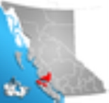
The Regional District of Mount Waddington (RDMW) is a regional district in British Columbia
. It takes in the lower Central Coast
region centred around the Queen Charlotte Strait
coast of northern Vancouver Island
and the adjoining parts of mainland British Columbia. It has a total land area of 20,288.4 km² (7,833.4 sq mi) and a 2006 census
population of 11,651 persons, most of which is in towns on Vancouver Island and adjoining islands. The administrative centre is in the town
of Port McNeill
. Other municipalities include the district municipality
of Port Hardy
, the village
of Port Alice
, and the village of Alert Bay.
, which lies on its northeastern boundary and is the highest peak entirely within British Columbia (Fairweather Mountain
, on the Alaska
boundary, is the highest). Also within the regional district is Mount Silverthrone
, the highest volcano in Canada
, located in the remote Ha-Iltzuk Icefield
. The land boundary of the regional district is largely the divide of the Coast Mountains
, inland from which is the Chilcotin District
, which is part of the Cariboo Regional District.
The RDMW is relatively underpopulated in comparison to other regional districts, due largely to the fact that most of its land area is rugged mountainscape or remote islands. Within its boundaries are the traditional territories of the Kwakwaka'wakw
, who form a significant minority in the region and are the majority in many smaller communities. Band governments and reserve lands are not part of the governance system of the regional district, which is formed of the mayors of the towns and representatives from its electoral areas (though First Nations people living inside municipalities are eligible voters). Sointula
, on Malcolm Island, is a historic Finnish Canadian settlement which began life as a cooperative; a similar Danish experiment at Cape Scott
was a failure, although the Danish
name Holberg
remains in the area. Logging and fishing and associated transport and other services, in addition to tourism, are the mainstays of the economic life of the communities of the regional district.
British Columbia
British Columbia is the westernmost of Canada's provinces and is known for its natural beauty, as reflected in its Latin motto, Splendor sine occasu . Its name was chosen by Queen Victoria in 1858...
. It takes in the lower Central Coast
British Columbia Coast
The British Columbia Coast or BC Coast is Canada's western continental coastline on the Pacific Ocean. The usage is synonymous with the term West Coast of Canada....
region centred around the Queen Charlotte Strait
Queen Charlotte Strait
Queen Charlotte Strait is a strait between Vancouver Island and the mainland of British Columbia, Canada. It connects Queen Charlotte Sound with Johnstone Strait, Discovery Passage and then to the Strait of Georgia and Puget Sound...
coast of northern Vancouver Island
Vancouver Island
Vancouver Island is a large island in British Columbia, Canada. It is one of several North American locations named after George Vancouver, the British Royal Navy officer who explored the Pacific Northwest coast of North America between 1791 and 1794...
and the adjoining parts of mainland British Columbia. It has a total land area of 20,288.4 km² (7,833.4 sq mi) and a 2006 census
Canada 2006 Census
The Canada 2006 Census was a detailed enumeration of the Canadian population. Census day was May 16, 2006. The next census following will be the 2011 Census. Canada's total population enumerated by the 2006 census was 31,612,897...
population of 11,651 persons, most of which is in towns on Vancouver Island and adjoining islands. The administrative centre is in the town
Town
A town is a human settlement larger than a village but smaller than a city. The size a settlement must be in order to be called a "town" varies considerably in different parts of the world, so that, for example, many American "small towns" seem to British people to be no more than villages, while...
of Port McNeill
Port McNeill, British Columbia
Port McNeill is a town in the North Island region of Vancouver Island, British Columbia, Canada with a population of 2,623 . Located on Vancouver Island's north-east shore on Queen Charlotte Strait, it was originally a base camp for loggers, Port McNeill became a settlement in 1936...
. Other municipalities include the district municipality
District municipality
A district municipality is a designation for a class of municipalities found in several locations, including Canada, Lithuania, and South Africa.-Usage in British Columbia:...
of Port Hardy
Port Hardy, British Columbia
Port Hardy is a district municipality in British Columbia, Canada located on the north-eastern coast of Vancouver Island. Port Hardy has a population of 3822 at last census...
, the village
Village
A village is a clustered human settlement or community, larger than a hamlet with the population ranging from a few hundred to a few thousand , Though often located in rural areas, the term urban village is also applied to certain urban neighbourhoods, such as the West Village in Manhattan, New...
of Port Alice
Port Alice, British Columbia
Port Alice is a small, quiet, town of approx. 821 located off on Neroutsos Inlet, northwest of Port McNeill, on Vancouver Island, originally built by Whalen Pulp and Paper Mills of Vancouver. The community is known for its natural beauty, pulp mill, and salt water fishing.-History:It was named...
, and the village of Alert Bay.
Municipalities
- Alert BayAlert Bay, British ColumbiaAlert Bay is a village on Cormorant Island, British Columbia, Canada. According to the 2006 census, 556 people live within the village.-Population:Slightly more than half of the village's 556 residents are First Nations people...
- Port AlicePort Alice, British ColumbiaPort Alice is a small, quiet, town of approx. 821 located off on Neroutsos Inlet, northwest of Port McNeill, on Vancouver Island, originally built by Whalen Pulp and Paper Mills of Vancouver. The community is known for its natural beauty, pulp mill, and salt water fishing.-History:It was named...
- Port HardyPort Hardy, British ColumbiaPort Hardy is a district municipality in British Columbia, Canada located on the north-eastern coast of Vancouver Island. Port Hardy has a population of 3822 at last census...
- Port McNeillPort McNeill, British ColumbiaPort McNeill is a town in the North Island region of Vancouver Island, British Columbia, Canada with a population of 2,623 . Located on Vancouver Island's north-east shore on Queen Charlotte Strait, it was originally a base camp for loggers, Port McNeill became a settlement in 1936...
Geography
The region is named for Mount WaddingtonMount Waddington
Mount Waddington, once known as Mystery Mountain, is the highest peak in the Coast Mountains of British Columbia, Canada. Although Mount Fairweather and Mount Quincy Adams, which straddle the US border between Alaska and British Columbia are taller, Mount Waddington is the highest peak that lies...
, which lies on its northeastern boundary and is the highest peak entirely within British Columbia (Fairweather Mountain
Mount Fairweather
Mount Fairweather , is one of the world's highest coastal mountains at 4,671 metres It is located east of the Pacific Ocean on the border of Alaska, United States and western British Columbia, Canada...
, on the Alaska
Alaska
Alaska is the largest state in the United States by area. It is situated in the northwest extremity of the North American continent, with Canada to the east, the Arctic Ocean to the north, and the Pacific Ocean to the west and south, with Russia further west across the Bering Strait...
boundary, is the highest). Also within the regional district is Mount Silverthrone
Mount Silverthrone
Mount Silverthrone, officially named Silverthrone Mountain, is a mountain in the Regional District of Mount Waddington, British Columbia, located over northwest of the city of Vancouver and about west of Mount Waddington, British Columbia, Canada...
, the highest volcano in Canada
Canada
Canada is a North American country consisting of ten provinces and three territories. Located in the northern part of the continent, it extends from the Atlantic Ocean in the east to the Pacific Ocean in the west, and northward into the Arctic Ocean...
, located in the remote Ha-Iltzuk Icefield
Ha-Iltzuk Icefield
The Ha-Iltzuk Icefield is an icefield in the central Pacific Ranges of the Coast Mountains in British Columbia, Canada. It is the largest icefield in the Coast Mountains south of the Alaska Panhandle, with an area of . It is located on the west side of the Klinaklini River and the Waddington Range...
. The land boundary of the regional district is largely the divide of the Coast Mountains
Coast Mountains
The Coast Mountains are a major mountain range, in the Pacific Coast Ranges, of western North America, extending from southwestern Yukon through the Alaska Panhandle and virtually all of the Coast of British Columbia. They are so-named because of their proximity to the sea coast, and are often...
, inland from which is the Chilcotin District
Chilcotin District
The Chilcotin District of British Columbia is usually known simply as "the Chilcotin", and also in speech commonly as "the Chilcotin Country" or simply Chilcotin. It is a plateau and mountain region in British Columbia on the inland lea of the Coast Mountains on the west side of the Fraser River....
, which is part of the Cariboo Regional District.
The RDMW is relatively underpopulated in comparison to other regional districts, due largely to the fact that most of its land area is rugged mountainscape or remote islands. Within its boundaries are the traditional territories of the Kwakwaka'wakw
Kwakwaka'wakw
The Kwakwaka'wakw are an Indigenous group of First Nations peoples, numbering about 5,500, who live in British Columbia on northern Vancouver Island and the adjoining mainland and islands.Kwakwaka'wakw translates as "Those who speak Kwak'wala", describing the collective nations within the area that...
, who form a significant minority in the region and are the majority in many smaller communities. Band governments and reserve lands are not part of the governance system of the regional district, which is formed of the mayors of the towns and representatives from its electoral areas (though First Nations people living inside municipalities are eligible voters). Sointula
Sointula
Sointula may refer to:* Sointula, British Columbia, a community in the Canadian province of British Columbia,* Sointula, a novel by Bill Gaston....
, on Malcolm Island, is a historic Finnish Canadian settlement which began life as a cooperative; a similar Danish experiment at Cape Scott
Cape Scott
Cape Scott is a cape at the western side of the terminus of Dennistoun Glacier on the northern coast of Victoria Land in Antarctica. Discovered by Captain James Ross, 1841, who named it for Peter A. Scott, Mate on the Terror....
was a failure, although the Danish
Danish language
Danish is a North Germanic language spoken by around six million people, principally in the country of Denmark. It is also spoken by 50,000 Germans of Danish ethnicity in the northern parts of Schleswig-Holstein, Germany, where it holds the status of minority language...
name Holberg
Holberg, British Columbia
Holberg is a small settlement on northern Vancouver Island, British Columbia, Canada. The community was established in the early 1900s by Danish settlers who named their new home in honour of Baron Ludwig Holberg....
remains in the area. Logging and fishing and associated transport and other services, in addition to tourism, are the mainstays of the economic life of the communities of the regional district.