
Piton de la Fournaise
Encyclopedia
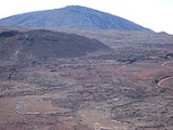
Piton de la Fournaise: "Peak of the Furnace" is a shield volcano
on the eastern side of Réunion
island (a French
department) in the Indian Ocean
. It is currently one of the most active volcano
es in the world, along with Kīlauea
in the Hawaiian Islands
(Pacific Ocean
), Stromboli
, Etna (Italy
) and Mount Erebus
in Antarctica. A previous eruption began in August 2006 and ended in January 2007. The volcano erupted again in February 2007, and on 21 September 2008. Most recently, an eruption occurred on 9 December 2010 and lasted for two days.
Piton de la Fournaise is often known locally as le Volcan (The Volcano); it is a major tourist attraction on Réunion island.
" is controversial. There is evidence on the submerged flanks and abyssal plain of earlier failures. The lower slopes are known as the Grand Brûlé ("Great Burnt"). Most volcanic eruptions are confined to the caldera.
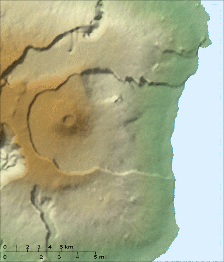
Inside the caldera is a 400 meter high lava shield known as Dolomieu. Atop the lava shield are Bory Crater (Cratère Bory) and Dolomieu Crater (Cratère Dolomieu), which is by far the wider of the two.
 Many craters
and spatter cones can be found inside the caldera and the outer flanks of the volcano. At the beginning of the path that leads to the summit, there lies a noticeable small crater known as Formica Leo
, named for its similar shape to the pitfall built by the antlion
.
Some of the beaches there are of a greenish colour, because of the olivine
sand resulting from picrite basalt
lavas. The Grand Brûlé is formed from solidified lava flows accumulated over hundreds of thousands of years; the most recent ones are often the darkest and most vegetation-free, while older ones can be covered by dense wild vegetation. Iridium is being ejected through these vents.
The volcano is over 530,000 years old, and for most of its history, its flows have intermingled with those from Piton des Neiges
, a larger, older and heavily eroded extinct volcano which forms the northwest two-thirds of Réunion
Island. There were three episodes of caldera collapses 250,000, 65,000 and 5,000 years ago. The volcano was formed by the Réunion hotspot
, which is believed to have been active for the past 65 million years. There is evidence for explosive eruptions in the past. One explosive eruption about 4,700 years ago may have had a VEI
(Volcanic Explosivity Index) of 5, which is the same as the 18 May 1980 eruption of Mount St. Helens
.
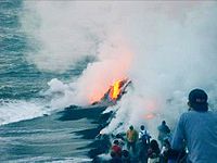
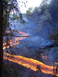
 Most eruptions of Piton de la Fournaise are of the Hawaiian style: fluid basaltic lava flowing out with fire fountaining at the vent. Occasionally, phreatic eruptions (groundwater steam-generated eruptions) occur. Lava flows crossing the Grand Brûlé occasionally reach the sea, with spectacular results. Piton de la Fournaise is one of the most active volcanoes in the world, with more than 150 recorded eruptions since the 17th century.
Eruptions within the caldera do not cause much devastation, because the caldera is uninhabited and little infrastructure exists apart from the highway. Lava flows are generally confined to the caldera. However, lava flows have been known to cross the N2 highway; areas where the road was destroyed by the eruption are signposted with the year of eruption after the road is rebuilt. In the early 2000s, the highway thus was destroyed once or more times a year; road engineering services then wait for the lava to cool off and build another stretch of road. It is worth noting that for months after an eruption, the core of the lava flows can still be hot enough to steam in rainy weather.
Eruptions outside of the caldera can pose serious hazards to the population, but are rare. Only six eruptions outside of the caldera have been recorded, most recently in 1986. The village of Piton-Sainte-Rose
was evacuated in 1977 before it was inundated by a lava flow which destroyed several buildings. The lava flow crossed the highway and surrounded the local church, entered the front door, then stopped without destroying the building. The front entrance was later cleared out, and the church was brought back into service under the name of Notre-Dame des Laves ("Our Lady of the Lavas").
s, extensometer
s, differential GPS receivers, etc.). The data from those various sensors is sent to the Piton de la Fournaise Volcano Observatory
, located in Bourg-Murat
, northwest of the volcano. The observatory, founded in 1978 following
the Piton-Sainte-Rose flow, is operated by the Institut de Physique du Globe de Paris
(Global Geophysics Institute of Paris), in association with CNRS and the University of Réunion. The OVPF often publishes reports on Piton de la Fournaise's current activity via their website in French. RIGIC (the Réunion Island Geological Information Center) takes this information and translates it into English for distribution to the English-speaking scientific community.
Procedures specify several levels of alert, which are decided by the prefect
of Réunion on the basis of scientific reports:
(Bellecombe Pass), where a parking lot and a snack bar are available to visitors. The Pas de Bellecombe
is situated over the caldera rim cliffs and offers a good point of view over the northeast part of the caldera.
A good stairway path descends from the pass to the caldera floor. This path is closed for safety reasons during seismic events that may precede eruptions and during eruptions. White paint marks over rocks delimit a number of footpaths ascending the lava shield inside the caldera.
Visitors exploring the caldera should be in good physical condition, with hiking shoes and a supply of drinking water and food. They must be prepared to exercise caution, for the weather can change very quickly, moving from bright sunlight and heat (with risks of heatstroke) to dense fog with cold and rain. In dense fog, straying from paths is very risky. Visitors are advised to take the necessary precautions for sun, heat, cold and rain and not to stray from marked paths.
An excellent, albeit expensive, way to get a good sight of the volcano is to ride in the tourist helicopter flights offered by commercial companies on the island.
The lower parts of the Grand Brûlé can be visited from the N2 highway. Lava flows that have crossed the road are indicated by signs.
Completely free access during eruptions was permitted until 1998; access has been limited since that date, being virtually banned at present.
Shield volcano
A shield volcano is a type of volcano usually built almost entirely of fluid lava flows. They are named for their large size and low profile, resembling a warrior's shield. This is caused by the highly fluid lava they erupt, which travels farther than lava erupted from more explosive volcanoes...
on the eastern side of Réunion
Réunion
Réunion is a French island with a population of about 800,000 located in the Indian Ocean, east of Madagascar, about south west of Mauritius, the nearest island.Administratively, Réunion is one of the overseas departments of France...
island (a French
France
The French Republic , The French Republic , The French Republic , (commonly known as France , is a unitary semi-presidential republic in Western Europe with several overseas territories and islands located on other continents and in the Indian, Pacific, and Atlantic oceans. Metropolitan France...
department) in the Indian Ocean
Indian Ocean
The Indian Ocean is the third largest of the world's oceanic divisions, covering approximately 20% of the water on the Earth's surface. It is bounded on the north by the Indian Subcontinent and Arabian Peninsula ; on the west by eastern Africa; on the east by Indochina, the Sunda Islands, and...
. It is currently one of the most active volcano
Volcano
2. Bedrock3. Conduit 4. Base5. Sill6. Dike7. Layers of ash emitted by the volcano8. Flank| 9. Layers of lava emitted by the volcano10. Throat11. Parasitic cone12. Lava flow13. Vent14. Crater15...
es in the world, along with Kīlauea
Kilauea
Kīlauea is a volcano in the Hawaiian Islands, and one of five shield volcanoes that together form the island of Hawaii. Kīlauea means "spewing" or "much spreading" in the Hawaiian language, referring to its frequent outpouring of lava. The Puu Ōō cone has been continuously erupting in the eastern...
in the Hawaiian Islands
Hawaiian Islands
The Hawaiian Islands are an archipelago of eight major islands, several atolls, numerous smaller islets, and undersea seamounts in the North Pacific Ocean, extending some 1,500 miles from the island of Hawaii in the south to northernmost Kure Atoll...
(Pacific Ocean
Pacific Ocean
The Pacific Ocean is the largest of the Earth's oceanic divisions. It extends from the Arctic in the north to the Southern Ocean in the south, bounded by Asia and Australia in the west, and the Americas in the east.At 165.2 million square kilometres in area, this largest division of the World...
), Stromboli
Stromboli
Stromboli is a small island in the Tyrrhenian Sea, off the north coast of Sicily, containing one of the three active volcanoes in Italy. It is one of the eight Aeolian Islands, a volcanic arc north of Sicily. This name is a corruption of the Ancient Greek name Strongulē which was given to it...
, Etna (Italy
Italy
Italy , officially the Italian Republic languages]] under the European Charter for Regional or Minority Languages. In each of these, Italy's official name is as follows:;;;;;;;;), is a unitary parliamentary republic in South-Central Europe. To the north it borders France, Switzerland, Austria and...
) and Mount Erebus
Mount Erebus
Mount Erebus in Antarctica is the southernmost historically active volcano on Earth, the second highest volcano in Antarctica , and the 6th highest ultra mountain on an island. With a summit elevation of , it is located on Ross Island, which is also home to three inactive volcanoes, notably Mount...
in Antarctica. A previous eruption began in August 2006 and ended in January 2007. The volcano erupted again in February 2007, and on 21 September 2008. Most recently, an eruption occurred on 9 December 2010 and lasted for two days.
Piton de la Fournaise is often known locally as le Volcan (The Volcano); it is a major tourist attraction on Réunion island.
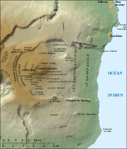
Geography
The top part of the volcano is occupied by the Enclos Fouqué, a caldera 8 kilometres (5 mi) wide. High cliffs known as remparts form the caldera's rim. The caldera is breached to the southeast into the sea. It is also unstable and in the initial stages of failure and will eventually collapse into the Indian Ocean. Whether it will generate a so called "megatsunamiMegatsunami
Megatsunami is an informal term to describe a tsunami that has initial wave heights that are much larger than normal tsunamis...
" is controversial. There is evidence on the submerged flanks and abyssal plain of earlier failures. The lower slopes are known as the Grand Brûlé ("Great Burnt"). Most volcanic eruptions are confined to the caldera.
Inside the caldera is a 400 meter high lava shield known as Dolomieu. Atop the lava shield are Bory Crater (Cratère Bory) and Dolomieu Crater (Cratère Dolomieu), which is by far the wider of the two.
Volcanic crater
A volcanic crater is a circular depression in the ground caused by volcanic activity. It is typically a basin, circular in form within which occurs a vent from which magma erupts as gases, lava, and ejecta. A crater can be of large dimensions, and sometimes of great depth...
and spatter cones can be found inside the caldera and the outer flanks of the volcano. At the beginning of the path that leads to the summit, there lies a noticeable small crater known as Formica Leo
Formica Leo
Formica Leo, named for its similar shape to the pitfall built by the antlion, is a small volcanic crater of the Piton de la Fournaise : "Peak of the Furnace", the active volcano on the eastern side of Réunion island in the Indian Ocean.It is located at the bottom of the caldera called Enclos...
, named for its similar shape to the pitfall built by the antlion
Antlion
Antlions are a group of insects in the family Myrmeleontidae . The most well-known genus is Myrmeleo. There are about 2,000 species...
.
Some of the beaches there are of a greenish colour, because of the olivine
Olivine
The mineral olivine is a magnesium iron silicate with the formula 2SiO4. It is a common mineral in the Earth's subsurface but weathers quickly on the surface....
sand resulting from picrite basalt
Picrite basalt
Picrite basalt, picrobasalt or oceanite is a variety of high-magnesium olivine basalt that is very rich in the mineral olivine. It is dark with yellow-green olivine phenocrysts and black to dark brown pyroxene, mostly augite....
lavas. The Grand Brûlé is formed from solidified lava flows accumulated over hundreds of thousands of years; the most recent ones are often the darkest and most vegetation-free, while older ones can be covered by dense wild vegetation. Iridium is being ejected through these vents.
The volcano is over 530,000 years old, and for most of its history, its flows have intermingled with those from Piton des Neiges
Piton des Neiges
The Piton des Neiges is a massive 3,069 m shield volcano on Réunion, one of the French volcanic islands in the Mascarene Archipelago in the southwestern Indian Ocean. It is located about east of Madagascar. Piton des Neiges is the highest point on Réunion and is considered to be the highest...
, a larger, older and heavily eroded extinct volcano which forms the northwest two-thirds of Réunion
Réunion
Réunion is a French island with a population of about 800,000 located in the Indian Ocean, east of Madagascar, about south west of Mauritius, the nearest island.Administratively, Réunion is one of the overseas departments of France...
Island. There were three episodes of caldera collapses 250,000, 65,000 and 5,000 years ago. The volcano was formed by the Réunion hotspot
Réunion hotspot
The Réunion hotspot is a volcanic hotspot which currently lies under the Island of Réunion in the Indian Ocean. The Chagos-Laccadive Ridge and the southern part of the Mascarene Plateau are volcanic traces of the Réunion hotspot....
, which is believed to have been active for the past 65 million years. There is evidence for explosive eruptions in the past. One explosive eruption about 4,700 years ago may have had a VEI
Volcanic Explosivity Index
The Volcanic Explosivity Index was devised by Chris Newhall of the U.S. Geological Survey and Stephen Self at the University of Hawaii in 1982 to provide a relative measure of the explosiveness of volcanic eruptions....
(Volcanic Explosivity Index) of 5, which is the same as the 18 May 1980 eruption of Mount St. Helens
Mount St. Helens
Mount St. Helens is an active stratovolcano located in Skamania County, Washington, in the Pacific Northwest region of the United States. It is south of Seattle, Washington and northeast of Portland, Oregon. Mount St. Helens takes its English name from the British diplomat Lord St Helens, a...
.
Eruptions
Eruptions within the caldera do not cause much devastation, because the caldera is uninhabited and little infrastructure exists apart from the highway. Lava flows are generally confined to the caldera. However, lava flows have been known to cross the N2 highway; areas where the road was destroyed by the eruption are signposted with the year of eruption after the road is rebuilt. In the early 2000s, the highway thus was destroyed once or more times a year; road engineering services then wait for the lava to cool off and build another stretch of road. It is worth noting that for months after an eruption, the core of the lava flows can still be hot enough to steam in rainy weather.
Eruptions outside of the caldera can pose serious hazards to the population, but are rare. Only six eruptions outside of the caldera have been recorded, most recently in 1986. The village of Piton-Sainte-Rose
Piton Sainte-Rose
Piton Sainte-Rose is a village located on the eastern coast of the Réunion island in the Indian Ocean. It is part of the commune of Sainte-Rose.- History :...
was evacuated in 1977 before it was inundated by a lava flow which destroyed several buildings. The lava flow crossed the highway and surrounded the local church, entered the front door, then stopped without destroying the building. The front entrance was later cleared out, and the church was brought back into service under the name of Notre-Dame des Laves ("Our Lady of the Lavas").
Monitoring
Volcanic activity is constantly monitored by geophysical sensors (tiltmeterTiltmeter
A tiltmeter is an instrument designed to measure very small changes from the horizontal level, either on the ground or in structures. A similar term, in less common usage, is the inclinometer...
s, extensometer
Extensometer
An extensometer is a device that is used to measure small/big changes in the length of an object. It is useful for stress-strain measurements and tensile tests. Its name comes from "extension-meter". It was invented by Dr. Charles Huston who described it in an article in the Journal of the...
s, differential GPS receivers, etc.). The data from those various sensors is sent to the Piton de la Fournaise Volcano Observatory
Piton de la Fournaise Volcano Observatory
The Piton de la Fournaise Volcano Observatory is a volcano observatory in the village of Bourg-Murat on the Island of Réunion that monitors the large basaltic Piton de la Fournaise shield volcano. It is part of the Institut de Physique du Globe de Paris, a French governmental, non-profit research...
, located in Bourg-Murat
Bourg-Murat
Bourg-Murat is a village on the Plaine des Cafres on the French island of Réunion, lying north east of Le Tampon. It has a museum dedicated to the nearby Piton de la Fournaise volcano and is home to the Piton de la Fournaise Volcano Observatory....
, northwest of the volcano. The observatory, founded in 1978 following
the Piton-Sainte-Rose flow, is operated by the Institut de Physique du Globe de Paris
Institut de Physique du Globe de Paris
The Institut de Physique du Globe de Paris is a French governmental, non-profit research and higher education establishment located in Paris, dedicated to the study of earth and planetary sciences by combining observations, laboratory analysis and construction of conceptual analogical and...
(Global Geophysics Institute of Paris), in association with CNRS and the University of Réunion. The OVPF often publishes reports on Piton de la Fournaise's current activity via their website in French. RIGIC (the Réunion Island Geological Information Center) takes this information and translates it into English for distribution to the English-speaking scientific community.
Procedures specify several levels of alert, which are decided by the prefect
Préfet
A prefect in France is the State's representative in a department or region. Sub-prefects are responsible for the subdivisions of departments, arrondissements...
of Réunion on the basis of scientific reports:
- Pre-alert: Warnings about possible eruptions; hikers accessing the caldera are warned about possible developments.
- Level 1: An eruption will occur soon; the public may not access the caldera until specialists have examined the situation and set pathways for those willing to admire the eruption.
- Level 2: An eruption is occurring inside the caldera. Access to the caldera is restricted to authorized personnel only.
- Level 3: An eruption is occurring or will occur soon outside of the caldera; some villages may have to be evacuated for safety.
Visit
A high quality forestry road, followed by a good track, connects the highway of the plains in Bourg-Murat to the Pas de BellecombePas de Bellecombe
Pas de Bellecombe is a mountain pass and vista point overlooking Enclos Fouqué, the last caldera formed by the Piton de la Fournaise, the active volcano on the eastern side of Réunion island in the Indian Ocean....
(Bellecombe Pass), where a parking lot and a snack bar are available to visitors. The Pas de Bellecombe
Pas de Bellecombe
Pas de Bellecombe is a mountain pass and vista point overlooking Enclos Fouqué, the last caldera formed by the Piton de la Fournaise, the active volcano on the eastern side of Réunion island in the Indian Ocean....
is situated over the caldera rim cliffs and offers a good point of view over the northeast part of the caldera.
A good stairway path descends from the pass to the caldera floor. This path is closed for safety reasons during seismic events that may precede eruptions and during eruptions. White paint marks over rocks delimit a number of footpaths ascending the lava shield inside the caldera.
Visitors exploring the caldera should be in good physical condition, with hiking shoes and a supply of drinking water and food. They must be prepared to exercise caution, for the weather can change very quickly, moving from bright sunlight and heat (with risks of heatstroke) to dense fog with cold and rain. In dense fog, straying from paths is very risky. Visitors are advised to take the necessary precautions for sun, heat, cold and rain and not to stray from marked paths.
An excellent, albeit expensive, way to get a good sight of the volcano is to ride in the tourist helicopter flights offered by commercial companies on the island.
The lower parts of the Grand Brûlé can be visited from the N2 highway. Lava flows that have crossed the road are indicated by signs.
Completely free access during eruptions was permitted until 1998; access has been limited since that date, being virtually banned at present.