
Rabaul caldera
Encyclopedia
Rabaul caldera is a large volcano
situated in East New Britain
, Papua New Guinea
. It derives its name from the town of Rabaul
situated inside the caldera
. The highest of its multiple peaks is 688 metres (2,257.2 ft).
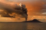
The sub-vent of Tavurvur
is the most visibly active, continuously throwing ash. In 1994 it, along with nearby Vulcan
erupted and devastated Rabaul, however, due to planning for such a catastrophe, the townsfolk were prepared and only five people were killed. One of the deaths was caused by lightning, a feature of volcanic ash clouds.
In 1937 it erupted killing more than 500 people. This event lead to the founding of the Rabaul Volcano Observatory which watches over the many active volcanoes on Papua New Guinea.
One eruption over several days in March 2008 released a plume of ash and water vapor that drifted northwest over the Bismarck Sea
.
On 9 April 2010, the Rabaul Volcano Observatory (RVO) reported that deformation measurements at Rabaul caldera during the previous 3-4 months had showed an inflationary trend with a total of 4 cm of uplift. During 2-8 April seismicity was low and variable amounts of white vapor rose from Tavurvur cone.
According to RVO, Tavurvur cone erupted on 23 July 2010 after increased seismicity, likely beneath Tavurvur cone, was detected the previous day. The series began with a few small hybrid earthquakes, followed by small low-frequency earthquakes, then continuous volcanic tremor starting at 1034 on 22 July; the eruption followed at 1300 on 23 July.
The eruption began with discharge of diffuse white plumes, followed by pink-gray fumes with low ash content. A strong odor of hydrogen sulfide
was noted, and a diffuse cloud rose 1 km and drifted NW. A few hours later, observers saw billowing gray clouds, accompanied by roaring and rumbling noises. Ashfall was reported in areas to the cone's NW and NNW.
RVO reported that, during 23-25 July, seismicity was variable. Ash emissions and ashfall continued in areas to the NW. Visibility remained poor in Rabaul town (3-5 km NW of Tavurvur) due to ash made airborne by the passage of moving vehicles. Ash emissions ceased on 25 July. Later that day and into 26 July only diffuse brown-tinted vapor plumes were emitted and seismicity was very low.
After the eruption of 23-25 July, GPS data showed deflation of Tavurvur cone. Seismicity was very low, and diffuse white plumes were emitted during 26-30 July.
Volcano
2. Bedrock3. Conduit 4. Base5. Sill6. Dike7. Layers of ash emitted by the volcano8. Flank| 9. Layers of lava emitted by the volcano10. Throat11. Parasitic cone12. Lava flow13. Vent14. Crater15...
situated in East New Britain
East New Britain
East New Britain is a province of Papua New Guinea, on the north-eastern part of the island of New Britain and it also includes the Duke of York Islands. The capital of the province is Kokopo, not far from the old capital of Rabaul, which was largely destroyed in the 1994 volcanic eruption...
, Papua New Guinea
Papua New Guinea
Papua New Guinea , officially the Independent State of Papua New Guinea, is a country in Oceania, occupying the eastern half of the island of New Guinea and numerous offshore islands...
. It derives its name from the town of Rabaul
Rabaul
Rabaul is a township in East New Britain province, Papua New Guinea. The town was the provincial capital and most important settlement in the province until it was destroyed in 1994 by falling ash of a volcanic eruption. During the eruption, ash was sent thousands of metres into the air and the...
situated inside the caldera
Caldera
A caldera is a cauldron-like volcanic feature usually formed by the collapse of land following a volcanic eruption, such as the one at Yellowstone National Park in the US. They are sometimes confused with volcanic craters...
. The highest of its multiple peaks is 688 metres (2,257.2 ft).
The sub-vent of Tavurvur
Tavurvur
Tavurvur is an active volcano that lies near Rabaul in Papua New Guinea. It is a sub-vent of the Rabaul caldera and lies on the eastern rim of the larger feature...
is the most visibly active, continuously throwing ash. In 1994 it, along with nearby Vulcan
Vulcan (volcano)
Vulcan is a pumice cone in Papua New Guinea. It is a sub-vent of the Rabaul caldera and lies on the western rim of the larger feature. Its most recent eruption was in 1994, when in conjunction with another vent, Tavurvur, the eruptions of Vulcan forced the abandonment of the city of Rabaul and the...
erupted and devastated Rabaul, however, due to planning for such a catastrophe, the townsfolk were prepared and only five people were killed. One of the deaths was caused by lightning, a feature of volcanic ash clouds.
In 1937 it erupted killing more than 500 people. This event lead to the founding of the Rabaul Volcano Observatory which watches over the many active volcanoes on Papua New Guinea.
One eruption over several days in March 2008 released a plume of ash and water vapor that drifted northwest over the Bismarck Sea
Bismarck Sea
The Bismarck Sea lies in the southwestern Pacific Ocean to the north of the island of Papua New Guinea and to the south of the Bismarck Archipelago and Admiralty Islands. Like the Bismarck archipelago, it is named in honour of the German chancellor Otto von Bismarck...
.
July 2010 Eruptions
Eruptions at Rabaul's Tavurvur cone resumed on 23 July 2010 after nearly seven months without ash emissions. As previously noted, Tavurvur was quiet between 1 January to 8 April 2010 (BGVN 35:02).On 9 April 2010, the Rabaul Volcano Observatory (RVO) reported that deformation measurements at Rabaul caldera during the previous 3-4 months had showed an inflationary trend with a total of 4 cm of uplift. During 2-8 April seismicity was low and variable amounts of white vapor rose from Tavurvur cone.
According to RVO, Tavurvur cone erupted on 23 July 2010 after increased seismicity, likely beneath Tavurvur cone, was detected the previous day. The series began with a few small hybrid earthquakes, followed by small low-frequency earthquakes, then continuous volcanic tremor starting at 1034 on 22 July; the eruption followed at 1300 on 23 July.
The eruption began with discharge of diffuse white plumes, followed by pink-gray fumes with low ash content. A strong odor of hydrogen sulfide
Hydrogen sulfide
Hydrogen sulfide is the chemical compound with the formula . It is a colorless, very poisonous, flammable gas with the characteristic foul odor of expired eggs perceptible at concentrations as low as 0.00047 parts per million...
was noted, and a diffuse cloud rose 1 km and drifted NW. A few hours later, observers saw billowing gray clouds, accompanied by roaring and rumbling noises. Ashfall was reported in areas to the cone's NW and NNW.
RVO reported that, during 23-25 July, seismicity was variable. Ash emissions and ashfall continued in areas to the NW. Visibility remained poor in Rabaul town (3-5 km NW of Tavurvur) due to ash made airborne by the passage of moving vehicles. Ash emissions ceased on 25 July. Later that day and into 26 July only diffuse brown-tinted vapor plumes were emitted and seismicity was very low.
After the eruption of 23-25 July, GPS data showed deflation of Tavurvur cone. Seismicity was very low, and diffuse white plumes were emitted during 26-30 July.