

Snake River Plain (ecoregion)
Encyclopedia
United States Environmental Protection Agency
The U.S. Environmental Protection Agency is an agency of the federal government of the United States charged with protecting human health and the environment, by writing and enforcing regulations based on laws passed by Congress...
(EPA) in the U.S. states of Idaho
Idaho
Idaho is a state in the Rocky Mountain area of the United States. The state's largest city and capital is Boise. Residents are called "Idahoans". Idaho was admitted to the Union on July 3, 1890, as the 43rd state....
and Oregon
Oregon
Oregon is a state in the Pacific Northwest region of the United States. It is located on the Pacific coast, with Washington to the north, California to the south, Nevada on the southeast and Idaho to the east. The Columbia and Snake rivers delineate much of Oregon's northern and eastern...
. It follows the Snake River
Snake River
The Snake is a major river of the greater Pacific Northwest in the United States. At long, it is the largest tributary of the Columbia River, the largest North American river that empties into the Pacific Ocean...
across Idaho, stretching roughly 400 miles (643.7 km) from the Wyoming
Wyoming
Wyoming is a state in the mountain region of the Western United States. The western two thirds of the state is covered mostly with the mountain ranges and rangelands in the foothills of the Eastern Rocky Mountains, while the eastern third of the state is high elevation prairie known as the High...
border to Eastern Oregon
Eastern Oregon
Eastern Oregon is the eastern part of the U.S. state of Oregon. It is not an officially recognized geographic entity, thus the boundaries of the region vary according to context. It is sometimes understood to include only the eight easternmost counties in the state; in other contexts, it includes...
in the xeric intermontane
Intermontane
Intermontane is a physiographic adjective formed from the prefix "inter-" and the adjective "montane" Usage includes intermontane basin such as New Zealand's Mackenzie Basin and intermontane...
west
Western United States
.The Western United States, commonly referred to as the American West or simply "the West," traditionally refers to the region comprising the westernmost states of the United States. Because the U.S. expanded westward after its founding, the meaning of the West has evolved over time...
. Characterized by plain
Plain
In geography, a plain is land with relatively low relief, that is flat or gently rolling. Prairies and steppes are types of plains, and the archetype for a plain is often thought of as a grassland, but plains in their natural state may also be covered in shrublands, woodland and forest, or...
s and low hill
Hill
A hill is a landform that extends above the surrounding terrain. Hills often have a distinct summit, although in areas with scarp/dip topography a hill may refer to a particular section of flat terrain without a massive summit A hill is a landform that extends above the surrounding terrain. Hills...
s, it is considerably lower and less rugged than surrounding ecoregion
Ecoregion
An ecoregion , sometimes called a bioregion, is an ecologically and geographically defined area that is smaller than an ecozone and larger than an ecosystem. Ecoregions cover relatively large areas of land or water, and contain characteristic, geographically distinct assemblages of natural...
s. Many of the alluvial valley
Valley
In geology, a valley or dale is a depression with predominant extent in one direction. A very deep river valley may be called a canyon or gorge.The terms U-shaped and V-shaped are descriptive terms of geography to characterize the form of valleys...
s bordering the Snake River are used for agriculture
Agriculture
Agriculture is the cultivation of animals, plants, fungi and other life forms for food, fiber, and other products used to sustain life. Agriculture was the key implement in the rise of sedentary human civilization, whereby farming of domesticated species created food surpluses that nurtured the...
. Where irrigation
Irrigation
Irrigation may be defined as the science of artificial application of water to the land or soil. It is used to assist in the growing of agricultural crops, maintenance of landscapes, and revegetation of disturbed soils in dry areas and during periods of inadequate rainfall...
water and soil
Soil
Soil is a natural body consisting of layers of mineral constituents of variable thicknesses, which differ from the parent materials in their morphological, physical, chemical, and mineralogical characteristics...
depth are sufficient, sugar beet
Sugar beet
Sugar beet, a cultivated plant of Beta vulgaris, is a plant whose tuber contains a high concentration of sucrose. It is grown commercially for sugar production. Sugar beets and other B...
s, potato
Potato
The potato is a starchy, tuberous crop from the perennial Solanum tuberosum of the Solanaceae family . The word potato may refer to the plant itself as well as the edible tuber. In the region of the Andes, there are some other closely related cultivated potato species...
es, alfalfa
Alfalfa
Alfalfa is a flowering plant in the pea family Fabaceae cultivated as an important forage crop in the US, Canada, Argentina, France, Australia, the Middle East, South Africa, and many other countries. It is known as lucerne in the UK, France, Australia, South Africa and New Zealand, and known as...
, small grain
GRAIN
GRAIN is a small international non-profit organisation that works to support small farmers and social movements in their struggles for community-controlled and biodiversity-based food systems. Our support takes the form of independent research and analysis, networking at local, regional and...
s, and vegetable
Vegetable
The noun vegetable usually means an edible plant or part of a plant other than a sweet fruit or seed. This typically means the leaf, stem, or root of a plant....
s are grown. Elsewhere, livestock
Livestock
Livestock refers to one or more domesticated animals raised in an agricultural setting to produce commodities such as food, fiber and labor. The term "livestock" as used in this article does not include poultry or farmed fish; however the inclusion of these, especially poultry, within the meaning...
grazing
Grazing
Grazing generally describes a type of feeding, in which a herbivore feeds on plants , and also on other multicellular autotrophs...
is widespread. Cattle feedlots and dairy operations are found locally.
Potential natural vegetation
Vegetation
Vegetation is a general term for the plant life of a region; it refers to the ground cover provided by plants. It is a general term, without specific reference to particular taxa, life forms, structure, spatial extent, or any other specific botanical or geographic characteristics. It is broader...
is mostly sagebrush steppe
Sagebrush steppe
The sagebrush steppe is a type of shrub-steppe, which is a dry-xeric environment and plant community found in the Western United States and western Canada...
, but barren lava fields and saltbush-greasewood
Greasewood
Greasewood, Sarcobatus, is a genus of one or two species of flowering plants. Traditionally it has been treated in the family Chenopodiaceae, but the APG II system, of 2003, places it in the family Sarcobataceae....
associations also occur. Streams generally have lower gradients, are warmer, and have finer grained substrate
Substrate (biology)
In biology a substrate is the surface a plant or animal lives upon and grows on. A substrate can include biotic or abiotic materials and animals. For example, encrusting algae that lives on a rock can be substrate for another animal that lives on top of the algae. See also substrate .-External...
s than do streams in the montane
Montane
In biogeography, montane is the highland area located below the subalpine zone. Montane regions generally have cooler temperatures and often have higher rainfall than the adjacent lowland regions, and are frequently home to distinct communities of plants and animals.The term "montane" means "of the...
ecoregions. Natural fish
Fish
Fish are a paraphyletic group of organisms that consist of all gill-bearing aquatic vertebrate animals that lack limbs with digits. Included in this definition are the living hagfish, lampreys, and cartilaginous and bony fish, as well as various extinct related groups...
assemblages in the region are typically a mix of mesothermal
Mesothermal
In climatology, the term mesothermal is used to refer to certain forms of climate found typically in the Earth's Temperate Zones. It has a moderate amount of heat, with winters not cold enough to sustain snow cover...
minnow
Minnow
Minnow is a general term used to refer to small freshwater and saltwater fish, especially those used as bait fish or for fishing bait. More specifically, it refers to small freshwater fish of the carp family.-True minnows:...
s and suckers
Catostomidae
Catostomidae is the sucker family of the order Cypriniformes. There are 80 species in this family of freshwater fishes. Catostomidae are found in North America, east central China, and eastern Siberia...
, but some stenothermal salmonids and sculpin
Sculpin
A Sculpin is a fish that belongs to the order Scorpaeniformes, suborder Cottoidei and superfamily Cottoidea, that contains 11 families, 149 genera, and 756 species...
s are also present. The region has many large springs
Spring (hydrosphere)
A spring—also known as a rising or resurgence—is a component of the hydrosphere. Specifically, it is any natural situation where water flows to the surface of the earth from underground...
along the Snake River that support endemic fish and mollusc species
Species
In biology, a species is one of the basic units of biological classification and a taxonomic rank. A species is often defined as a group of organisms capable of interbreeding and producing fertile offspring. While in many cases this definition is adequate, more precise or differing measures are...
. Shoshone Falls
Shoshone Falls
Shoshone Falls is a waterfall on the Snake River located approximately five miles east of Twin Falls, Idaho. Sometimes called the "Niagara of the West," Shoshone Falls is 212 feet high—45 feet higher than Niagara Falls—and flows over a rim 1,000 feet wide.A park overlooking the waterfall is...
is a major zoogeographic
Zoogeography
Zoogeography is the branch of the science of biogeography that is concerned with the geographic distribution of animal species.-External links:*: A course outline and collection of Web resources by Dr. Taylor, UBC...
barrier, and different species occur above and below it.
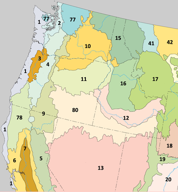
The Snake River Plain ecoregion has been subdivided into ten Level IV ecoregions, as described below.
Level IV ecoregions

Treasure Valley (12a)
The Treasure Valley ecoregion (named for the Treasure ValleyTreasure Valley
The Treasure Valley is the area of the Western United States where the Payette, Boise, Weiser, Malheur, Owyhee, and Burnt rivers drain into the Snake River. Treasure Valley includes all the lowland areas from Vale, Oregon on the west to Boise, Idaho on the east. Formerly, the valley had been known...
) is an unglaciated rolling valley containing many canal
Canal
Canals are man-made channels for water. There are two types of canal:#Waterways: navigable transportation canals used for carrying ships and boats shipping goods and conveying people, further subdivided into two kinds:...
s and incised rivers. Elevation varies from 2,000 to 2,800 feet (640 to 853 m). The valley is underlain by Quaternary
Quaternary
The Quaternary Period is the most recent of the three periods of the Cenozoic Era in the geologic time scale of the ICS. It follows the Neogene Period, spanning 2.588 ± 0.005 million years ago to the present...
alluvium, loess
Loess
Loess is an aeolian sediment formed by the accumulation of wind-blown silt, typically in the 20–50 micrometre size range, twenty percent or less clay and the balance equal parts sand and silt that are loosely cemented by calcium carbonate...
, lacustrine
Lake
A lake is a body of relatively still fresh or salt water of considerable size, localized in a basin, that is surrounded by land. Lakes are inland and not part of the ocean and therefore are distinct from lagoons, and are larger and deeper than ponds. Lakes can be contrasted with rivers or streams,...
, and alluvial fan
Alluvial fan
An alluvial fan is a fan-shaped deposit formed where a fast flowing stream flattens, slows, and spreads typically at the exit of a canyon onto a flatter plain. A convergence of neighboring alluvial fans into a single apron of deposits against a slope is called a bajada, or compound alluvial...
deposits
Deposition (geology)
Deposition is the geological process by which material is added to a landform or land mass. Fluids such as wind and water, as well as sediment flowing via gravity, transport previously eroded sediment, which, at the loss of enough kinetic energy in the fluid, is deposited, building up layers of...
. Soils have an aridic moisture regime
Arid
A region is said to be arid when it is characterized by a severe lack of available water, to the extent of hindering or even preventing the growth and development of plant and animal life...
, and they originally supported sagebrush
Sagebrush
Sagebrush is a common name of a number of shrubby plant species in the genus Artemisia native to western North America;Or, the sagebrush steppe ecoregion, having one or more kinds of sagebrush, bunchgrasses and others;...
-grassland
Grassland
Grasslands are areas where the vegetation is dominated by grasses and other herbaceous plants . However, sedge and rush families can also be found. Grasslands occur naturally on all continents except Antarctica...
before the valley was converted to agriculture. Canals and diversions in this portion of the Snake River Plain supply water to pastureland and cropland as well as municipalities
Municipality
A municipality is essentially an urban administrative division having corporate status and usually powers of self-government. It can also be used to mean the governing body of a municipality. A municipality is a general-purpose administrative subdivision, as opposed to a special-purpose district...
. Surface water quality
Water quality
Water quality is the physical, chemical and biological characteristics of water. It is a measure of the condition of water relative to the requirements of one or more biotic species and or to any human need or purpose. It is most frequently used by reference to a set of standards against which...
has been significantly affected by channel alteration, dams, irrigation diversions, irrigation return flow, and agricultural pollution
Pollution
Pollution is the introduction of contaminants into a natural environment that causes instability, disorder, harm or discomfort to the ecosystem i.e. physical systems or living organisms. Pollution can take the form of chemical substances or energy, such as noise, heat or light...
. Crops include wheat
Wheat
Wheat is a cereal grain, originally from the Levant region of the Near East, but now cultivated worldwide. In 2007 world production of wheat was 607 million tons, making it the third most-produced cereal after maize and rice...
, sugar beets, alfalfa, potatoes, and onion
Onion
The onion , also known as the bulb onion, common onion and garden onion, is the most widely cultivated species of the genus Allium. The genus Allium also contains a number of other species variously referred to as onions and cultivated for food, such as the Japanese bunching onion The onion...
s. Population density
Population density
Population density is a measurement of population per unit area or unit volume. It is frequently applied to living organisms, and particularly to humans...
is greater than in neighboring, rangeland
Rangeland
Rangelands are vast natural landscapes in the form of grasslands, shrublands, woodlands, wetlands, and deserts. Types of rangelands include tallgrass and shortgrass prairies, desert grasslands and shrublands, woodlands, savannas, chaparrals, steppes, and tundras...
-dominated ecoregions. Crop diversity
Crop diversity
Crop diversity is the variance in genetic and phenotypic characteristics of plants used in agriculture. Crops may vary in seed size, branching pattern, in height, flower color, fruiting time, or flavor. They may also vary in less obvious characteristics such as their response to heat, cold or...
is greater, temperatures are warmer, and the mean frost
Frost
Frost is the solid deposition of water vapor from saturated air. It is formed when solid surfaces are cooled to below the dew point of the adjacent air as well as below the freezing point of water. Frost crystals' size differ depending on time and water vapour available. Frost is also usually...
-free season is longer than in the Upper Snake River Plain and the Magic Valley. Vegetation outside of agricultural areas is characterized by Wyoming big sagebrush, basin big sagebrush, bluebunch wheatgrass
Bluebunch wheatgrass
Pseudoroegneria spicata is a species of grass known by the common name Bluebunch Wheatgrass. This native western North American perennial bunchgrass is known by the scientific synonyms Elymus spicatus and Agropyron spicatum. The grass can be found from Alaska to Texas. It occurs in many types of...
, bluegrass
Poa
Poa is a genus of about 500 species of grasses, native to the temperate regions of both hemispheres. Common names include meadow-grass , bluegrass , tussock , and speargrass. "Poa" is Greek for fodder...
, basin wildrye, Thurber's needlegrass
Achnatherum
Achnatherum is a genus of plants which includes several species of needlegrass. Several needlegrass species have been switched between Achnatherum and genus Stipa; taxonomy between the two closely related genera is still uncertain....
, rabbitbrush
Chrysothamnus
Chrysothamnus is a member of the plant family Asteraceae. It is a semi-deciduous shrub, sometimes also called sagebrush. The native distribution is in the arid western United States and northern Mexico...
, and cheatgrass. In saline areas, shadscale, greasewood, and saltgrass occur. The region covers 1302 square miles (3,372 km²) in Idaho and 499 square miles (1,292 km²) in Oregon, where the Payette
Payette River
The Payette River is an river in southwestern Idaho and is a major tributary of the Snake River.Its headwaters originate in the Sawtooth and Salmon River Mountains at elevations over...
, Boise
Boise River
The Boise River is a tributary of the Snake River in the northwestern United States. It drains a rugged portion of the Sawtooth Range in southwestern Idaho northeast of Boise, as well as part of the western Snake River Plain...
, Weiser
Weiser River
The Weiser River is a tributary of the Snake River in western Idaho in the United States. It drains a mountainous area of consisting primarily of low rolling foothills intersected by small streams south and east of Hells Canyon along the Idaho-Oregon border....
, Malheur
Malheur River
The Malheur River is a tributary of the Snake River in eastern Oregon in the United States. It drains a high desert area, between the Harney Basin and the Blue Mountains and the Snake....
and Owyhee
Owyhee River
The Owyhee River is a tributary of the Snake River located in northern Nevada, southwestern Idaho and southeastern Oregon in the United States. It is long. The river's drainage basin is in area, one of the largest subbasins of the Columbia Basin...
rivers converge into the Snake. It includes lowland areas from Boise
Boise, Idaho
Boise is the capital and most populous city of the U.S. state of Idaho, as well as the county seat of Ada County. Located on the Boise River, it anchors the Boise City-Nampa metropolitan area and is the largest city between Salt Lake City, Utah and Portland, Oregon.As of the 2010 Census Bureau,...
to Vale
Vale, Oregon
Vale is a city in Malheur County, Oregon, United States, about west of the Idaho border. It is at the intersection of U.S. Routes 20 and 26, on the Malheur River.Vale was selected as Malheur's county seat in 1955, 68 years after the county was founded...
and contains the Deer Flat National Wildlife Refuge
Deer Flat National Wildlife Refuge
The Deer Flat National Wildlife Refuge is an important breeding area for mammals, birds, and other animals. The National Wildlife Refuge is located on land surrounding Lake Lowell, just outside Nampa, Idaho...
.
Lava Fields (12b)
The Lava Fields ecoregion contains basaltBasalt
Basalt is a common extrusive volcanic rock. It is usually grey to black and fine-grained due to rapid cooling of lava at the surface of a planet. It may be porphyritic containing larger crystals in a fine matrix, or vesicular, or frothy scoria. Unweathered basalt is black or grey...
flows, cinder cone
Cinder cone
According to the , Cinder Cone is the proper name of 1 cinder cone in Canada and 7 cinder cones in the United States:In Canada: Cinder Cone In the United States:...
s, and spatter cones rising from irregular plains, at an elevation of 3,800 to 5,500 feet (1,158 to 1,676 m). Exposed basalt or very shallow loessial soils over volcanics
Volcanic rock
Volcanic rock is a rock formed from magma erupted from a volcano. In other words, it is an igneous rock of volcanic origin...
are characteristic. Surface water
Surface water
Surface water is water collecting on the ground or in a stream, river, lake, wetland, or ocean; it is related to water collecting as groundwater or atmospheric water....
availability is extremely limited, and the region is either barren
Barren vegetation
The term Barren vegetation, or just barren, describes an area where plant growth is sparse, stunted, or possesses little biodiversity. Poor growth may occur due to high winds, climate, salt spray, infertile or toxic soil, or heavy exploitation by man....
or sparsely covered by hardy shrub
Shrub
A shrub or bush is distinguished from a tree by its multiple stems and shorter height, usually under 5–6 m tall. A large number of plants may become either shrubs or trees, depending on the growing conditions they experience...
s and grass
Grass
Grasses, or more technically graminoids, are monocotyledonous, usually herbaceous plants with narrow leaves growing from the base. They include the "true grasses", of the Poaceae family, as well as the sedges and the rushes . The true grasses include cereals, bamboo and the grasses of lawns ...
es, including basin sagebrush, mountain sagebrush, Wyoming big sagebrush, rabbitbrush, bluegrass, bluebunch wheatgrass, bottlebrush squirreltail, Thurber needlegrass, and Indian ricegrass
Indian ricegrass
Oryzopsis hymenoides is a perennial cool-season bunchgrass. It is native to western North America east of the Cascades from British Columbia and Alberta south to southern California, northeastern Mexico, and Texas...
. Livestock carrying capacity
Carrying capacity
The carrying capacity of a biological species in an environment is the maximum population size of the species that the environment can sustain indefinitely, given the food, habitat, water and other necessities available in the environment...
is low. The region covers 1122 square miles (2,906 km²) in Idaho in pockets of the eastern Snake River Plain, including Craters of the Moon National Monument and parts of the Idaho National Engineering Laboratory.
Camas Prairie (12c)
The Camas Prairie ecoregion is a cold, wet valley containing nearly level to rolling terraces, bottomlands, basaltBasalt
Basalt is a common extrusive volcanic rock. It is usually grey to black and fine-grained due to rapid cooling of lava at the surface of a planet. It may be porphyritic containing larger crystals in a fine matrix, or vesicular, or frothy scoria. Unweathered basalt is black or grey...
plains, and, on the periphery, alluvial fans. Elevation varies from 4,700 to 5,100 feet (1,443 to 1,554 m). It is flanked by the semi-arid foothills of the Snake River Plain and the Idaho Batholith, which trap mountain
Mountain
Image:Himalaya_annotated.jpg|thumb|right|The Himalayan mountain range with Mount Everestrect 58 14 160 49 Chomo Lonzorect 200 28 335 52 Makalurect 378 24 566 45 Mount Everestrect 188 581 920 656 Tibetan Plateaurect 250 406 340 427 Rong River...
runoff
Surface runoff
Surface runoff is the water flow that occurs when soil is infiltrated to full capacity and excess water from rain, meltwater, or other sources flows over the land. This is a major component of the water cycle. Runoff that occurs on surfaces before reaching a channel is also called a nonpoint source...
on the prairie. Resultant wet soils and flooding occur and are local and seasonal problems. Frigid mollisols are common and are colder than the soils of the lower Treasure Valley. Wet bottomlands support rushes
Juncus
Juncus is a genus in the plant family Juncaceae. It consists of some 200 to 300 or more species of grassy plants commonly called rushes...
, sedge
Cyperaceae
Cyperaceae are a family of monocotyledonous graminoid flowering plants known as sedges, which superficially resemble grasses or rushes. The family is large, with some 5,500 species described in about 109 genera. These species are widely distributed, with the centers of diversity for the group...
s, meadow grasses, and willow
Willow
Willows, sallows, and osiers form the genus Salix, around 400 species of deciduous trees and shrubs, found primarily on moist soils in cold and temperate regions of the Northern Hemisphere...
s. Alluvial fans and terraces are covered by bluebunch wheatgrass, Idaho fescue, bluegrass, basin big sagebrush, and mountain sagebrush. Lava plains support alkali sagebrush, bluegrass, squirreltail, and Idaho fescue. The region covers 530 square miles (1,373 km²) in Idaho along the Camas River and is used for used for small grain and alfalfa farming, pasture, range, and wildlife habitat.
Dissected Plateaus and Teton Basin (12d)
The Dissected Plateaus and Teton Basin ecoregion is characterized by dissected plateauDissected plateau
A dissected plateau is a plateau area that has been severely eroded so that the relief is sharp. Such an area may be referred to as mountainous, but dissected plateaus are distinguishable from orogenic mountain belts by the lack of folding, metamorphism, extensive faulting, or magmatic activity...
s, alluvial fans, low terraces,
bottomlands, outwash plains, and nearly flat, poorly-drained basins
Depression (geology)
A depression in geology is a landform sunken or depressed below the surrounding area. Depressions may be formed by various mechanisms.Structural or tectonic related:...
. Elevation varies from 4,700 to 6,300 feet (1,443 to 1,920 m). Mollisols developed in thick loess deposits or alluvium and are subject to wind erosion. Loess is far more extensive than in the Upper Snake River Plain subregion. Sprinkler-irrigated land supports potatoes, alfalfa, and pasture; however, surface irrigation is far less common than in the Upper Snake River Plain. Non-irrigated land
Dryland farming
Dryland farming is an agricultural technique for non-irrigated cultivation of drylands.-Locations:Dryland farming is used in the Great Plains, the Palouse plateau of Eastern Washington, and other arid regions of North America, the Middle East and in other grain growing regions such as the steppes...
grows small grains. Potential natural vegetation is sagebrush steppe, with mountain big sagebrush, threetip sagebrush
Sagebrush
Sagebrush is a common name of a number of shrubby plant species in the genus Artemisia native to western North America;Or, the sagebrush steppe ecoregion, having one or more kinds of sagebrush, bunchgrasses and others;...
, bluebunch wheatgrass, bluegrass, Idaho fescue, and cheatgrass. Wet meadow
Wet meadow
A wet meadow is a semi-wetland meadow which is saturated with water throughout much of the year. Wet meadows may occur because of poor drainage or the receipt of large amounts of water from rain or melted snow. They may also occur in riparian zones....
s occur in the poorly-drained, relatively cold Teton Basin
Teton River (Idaho)
The Teton River is an tributary of the Henrys Fork of the Snake River in southeastern Idaho in the United States. It drains through the Teton Valley along the west side of the Teton Range along the Idaho-Wyoming border at the eastern end of the Snake River Plain...
. The region covers 1059 square miles (2,743 km²) in Idaho in the farthest eastern reaches of the Snake River Plain, approaching the Teton Mountains. It includes portions of the Caribou-Targhee National Forest
Caribou-Targhee National Forest
Caribou-Targhee National Forest is located in the states of Idaho and Wyoming, with a small section in Utah in the United States. The forest is broken into several separate sections and extends over . To the east the forest borders Yellowstone National Park, Grand Teton National Park and...
.
Upper Snake River Plain (12e)
The Upper Snake River Plain ecoregion is characterized by nearly level river terraces, floodplains, and lake plains containing many canals and rivers. Elevation varies from 4,400 to 5,000 feet (1,341 to 1,524 m). The region is primarily used for irrigated cropland, pastureland, suburban and urban developments, and industrial areas, and aquatic resources have been degraded by irrigation diversions, channelization, dams, sewage treatmentSewage treatment
Sewage treatment, or domestic wastewater treatment, is the process of removing contaminants from wastewater and household sewage, both runoff and domestic. It includes physical, chemical, and biological processes to remove physical, chemical and biological contaminants...
, nonpoint pollution, food processing
Food processing
Food processing is the set of methods and techniques used to transform raw ingredients into food or to transform food into other forms for consumption by humans or animals either in the home or by the food processing industry...
, and phosphate
Phosphate
A phosphate, an inorganic chemical, is a salt of phosphoric acid. In organic chemistry, a phosphate, or organophosphate, is an ester of phosphoric acid. Organic phosphates are important in biochemistry and biogeochemistry or ecology. Inorganic phosphates are mined to obtain phosphorus for use in...
processing. Extensive surface-irrigated small grain, sugar beet, potato, and alfalfa farming occurs. The frost-free season is shorter and crops are less varied than in agricultural areas downstream. Potential natural vegetation is sagebrush steppe, with saltbush-greasewood communities in the southwest. Big sagebrush, bluebunch wheatgrass, bluegrass, cheatgrass, rabbitbrush, squirreltail, needle-and-thread, Indian ricegrass, and fourwing saltbush are present. Riparian areas feature sedges, perennial grasses, willows, and cottonwood. The region covers 1463 square miles (3,789 km²) in eastern Idaho, mostly along the interstate corridor from American Falls
American Falls, Idaho
American Falls is a city in and the county seat of Power County, Idaho, United States. The population was 4,111 at the 2000 census. It is part of the Pocatello, Idaho Metropolitan Statistical Area.-History:...
to St. Anthony
St. Anthony, Idaho
St. Anthony is a city in and the county seat of Fremont County, Idaho, United States. The population was 3,342 at the 2000 census. It is part of the Rexburg, Idaho Micropolitan Statistical Area.-Geography:St...
. It includes the Camas National Wildlife Refuge
Camas National Wildlife Refuge
About half of the Camas National Wildlife Refuge in southeastern Idaho consists of lakes, ponds, and marshlands; the remainder is grass sagebrush uplands, meadows, and farm fields. Camas Creek flows through the length of the refuge....
and most of the Fort Hall Indian Reservation
Fort Hall Indian Reservation
The Fort Hall Indian Reservation is an Indian reservation of the federally recognized Shoshone-Bannock Tribes in the U.S. state of Idaho. It is located in southeastern Idaho on the Snake River Plain north of Pocatello, and comprises 814.874 sq mi of land area in four counties: Bingham, Power,...
.
Semiarid Foothills (12f)
The Semiarid Foothills ecoregion consists of foothills, alluvial fans, hills, and valleys that separate the Snake River Plain from the Idaho Batholith ecoregion to the north. At an elevation of 2,900 to 6,500 feet (884 to 1,981 m), it is higher and more rugged than neighboring regions in the Snake River Plain. Shallow, clayClay
Clay is a general term including many combinations of one or more clay minerals with traces of metal oxides and organic matter. Geologic clay deposits are mostly composed of phyllosilicate minerals containing variable amounts of water trapped in the mineral structure.- Formation :Clay minerals...
ey soils are common, supporting sagebrush steppe communities of bluebunch wheatgrass, bluegrass, Idaho fescue, big sagebrush, bitterbrush, medusahead wildrye, and cheatgrass, with bunch grasses, sedges, rushes, and clover
Clover
Clover , or trefoil, is a genus of about 300 species of plants in the leguminous pea family Fabaceae. The genus has a cosmopolitan distribution; the highest diversity is found in the temperate Northern Hemisphere, but many species also occur in South America and Africa, including at high altitudes...
s in wetter areas. Land use is primarily livestock grazing and is distinct from the irrigated agriculture of the Treasure Valley. Wildfire frequency is high. The region covers 1559 square miles (4,038 km²) in two separate areas of Idaho, one northeast of Weiser
Weiser, Idaho
Weiser is a city in the rural western part of the U.S. state of Idaho and the county seat of Washington County. With its mild climate, the city supports farm, orchard, and livestock endeavors in the vicinity. The city sits at the confluence of the Weiser River with the great Snake River, which...
in the Weiser River
Weiser River
The Weiser River is a tributary of the Snake River in western Idaho in the United States. It drains a mountainous area of consisting primarily of low rolling foothills intersected by small streams south and east of Hells Canyon along the Idaho-Oregon border....
drainage and one northeast of Mountain Home
Mountain Home, Idaho
Mountain Home is the largest city and county seat of Elmore County, Idaho. The population was 14,206 at the 2010 census. Mountain Home is the principal city of the Mountain Home, ID Micropolitan Statistical Area, which includes Elmore County....
, including Bennett Mountain
Bennett Mountain
Bennett Mountain is a summit in the Sonoma Mountains of California. Located on the west edge of Annadel State Park, it separates Bennett Valley in the Russian River drainage basin from Sonoma Valley in the Sonoma Creek drainage basin....
and nearby hills.
Eastern Snake River Basalt Plains (12g)
The Eastern Snake River Basalt Plains ecoregion is a large irregular plain at an elevation of 3,700 to 6,400 feet (1,128 to 1,951 m), with shallow, stony soils that are unsuitable for cultivation. Only small areas have soils deep enough to be farmed under sprinkler irrigation. Rangeland is widespread and contrasts with the cropland of other subregions in the Snake River Plain. Potential natural vegetation is mostly sagebrush and bunchgrass, with basin and Wyoming big sagebrush, Thurber needlegrass, Indian ricegrass, bitterbrush, bluegrass, and cheatgrass. Saline areas feature fourwing saltbush, shadscale, and winter fat. The region is cool enough to have some regeneration capacity and still contains native plants, unlike the Mountain Home Uplands to the west. By far the largest of the Snake River Plain subregions, it covers 6426 square miles (16,643 km²) in southern Idaho, including part of the Craters of the Moon National Monument and Idaho National Engineering Laboratory.Mountain Home Uplands (12h)
The Mountain Home Uplands ecoregion consists of arid, shrub- and grass-covered plains with hills and basalt-capped butteButte
A butte is a conspicuous isolated hill with steep, often vertical sides and a small, relatively flat top; it is smaller than mesas, plateaus, and table landform tables. In some regions, such as the north central and northwestern United States, the word is used for any hill...
s. Elevation varies from 2,500 to 4,300 feet (762 to 1,311 m), with some buttes up to 5000 feet (1,524 m). It is mostly rangeland and is sparsely populated, unlike regions to the west and east. It is flanked by foothills to the north and south and by the Magic and Treasure Valleys to the east and west. Today, it supports cheatgrass, crested wheatgrass, medusahead wildrye, Wyoming and basin big sagebrush, alkali sagebrush, and antelope bitterbrush. Stock carrying capacity is low. Native grasses are much rarer and vegetative regeneration capacity is more limited than in the cooler Eastern Snake River Basalt Plains, which has more available moisture. The second largest of the Snake River Plain subregions, it covers 2945 square miles (7,628 km²) in southern Idaho, along the I-84
Interstate 84 in Idaho
In the U.S. state of Idaho, Interstate 84 heads southeast from the Oregon state line, it spurs to Interstate 184 in Boise. Eventually I-84 spurs Interstate 86 and mainline I-84 heads southeast towards Utah and I-86 is continues due east and heads to Pocatello, meeting with Interstate 15.-Future:...
corridor between Boise and Gooding
Gooding, Idaho
Gooding is the county seat and largest city of Gooding County, Idaho, United States. Its population was 3,384 at the 2000 census.The city is named for Frank R. Gooding, a local sheep rancher who became a prominent political figure in Idaho in the early 20th Century, serving as both Governor of...
.
Magic Valley (12i)
The Magic Valley ecoregion, named for the irrigation canals of the Magic ValleyMagic Valley
The Magic Valley is a region in south-central Idaho consisting of Blaine, Camas, Cassia, Gooding, Jerome, Lincoln, Minidoka and Twin Falls Counties. It is particularly associated with the agricultural region in the Snake River Plain located in the area...
that "magically" transformed the region in the early 1900s, is an agricultural valley underlain by alluvium, loess, and basalt flows. Elevation varies from 3,200 to 4,500 feet (975 to 1,372 m). The aridic soils require irrigation to grow commercial crops. Many canals, reservoirs, and diversions supply water to the region's pastureland, cropland, and residential, commercial, and industrial developments. Small grains, alfalfa, sugar beets, potatoes, and beans are grown. Livestock and dairy farms occur; dairying is more common than in the Treasure Valley. Dams, irrigation diversions, pollution, and channel alteration have affected water quality, and over-watering from sprinkler-irrigated portions of the Eastern Snake River Basalt Plains has raised groundwater
Groundwater
Groundwater is water located beneath the ground surface in soil pore spaces and in the fractures of rock formations. A unit of rock or an unconsolidated deposit is called an aquifer when it can yield a usable quantity of water. The depth at which soil pore spaces or fractures and voids in rock...
levels and created artificial wetland
Wetland
A wetland is an area of land whose soil is saturated with water either permanently or seasonally. Wetlands are categorised by their characteristic vegetation, which is adapted to these unique soil conditions....
s. Natural vegetation is mostly sagebrush and bunchgrass, but low terraces have salt tolerant plants. Wyoming and basin big sagebrush, alkali sagebrush, bluebunch wheatgrass, Thurber needlegrass, squirreltail, bluegrass, needle-and-thread, Indian ricegrass, and fourwing saltbush are present. Population density
Population density
Population density is a measurement of population per unit area or unit volume. It is frequently applied to living organisms, and particularly to humans...
is greater than in the rangeland-dominated regions to the east and west. The region covers 1700 square miles (4,403 km²) in the Twin Falls
Twin Falls, Idaho
Twin Falls is the county seat and largest city of Twin Falls County, Idaho, United States. The population was 44,125 at the 2010 censusTwin Falls is the largest city of Idaho's Magic Valley region...
area of southern Idaho.
Unwooded Alkaline Foothills (12j)
The Unwooded Alkaline Foothills ecoregion contains rolling foothills, hills, benches, alluvial fans, and scattered badlands that are characteristically underlain by sandy, alkaline lacustrine deposits. Perennial streams are rare. At an elevation of 2,100 to 2,600 feet (671 to 1,189 m), the terrain is higher and more rugged than the neighboring Treasure Valley. The region is valuable as rangeland and wildlife habitat, and land use is generally distinct from the irrigated agriculture of the valley. However, scattered areas near rivers with enough water to leach salts from the soil support alfalfa or sugar beet farming. Natural vegetation is dominated by Wyoming big sagebrush and associated grasses, such as bluebunch wheatgrass, Sandberg bluegrass, Thurber needlegrass, and Indian ricegrass. Today, cheatgrass and crested wheatgrass are also common. Salt tolerant shrubs, including black greasewood, fourwing saltbush, inland saltgrass, shadscale, seepweed, occur on alkaline outcrops. The region covers 1598 square miles (4,139 km²) in western Idaho and 489 square miles (1,267 km²) in eastern Oregon, on both sides of the Treasure Valley.See also
- Ecoregions defined by the EPA and the Commission for Environmental CooperationCommission for Environmental CooperationThe Commission for Environmental Cooperation was established by Canada, Mexico, and the United States to implement the North American Agreement on Environmental Cooperation , the environmental side accord to the North American Free Trade Agreement...
:- List of ecoregions in North America (CEC)
- List of ecoregions in the United States (EPA)
- List of ecoregions in Idaho
- List of ecoregions in Oregon
- The conservation group World Wildlife Fund maintains an alternate classification system:
- List of ecoregions (WWF)
- List of ecoregions in the United States (WWF)