
Whangarei
Encyclopedia
Whangarei, pronounced ˈfaːŋaˌɾei, is the northernmost city in New Zealand
and the regional capital of Northland Region. Although commonly classified as a city, it is officially part of the Whangarei District
, administered by the Whangarei District Council a local body created in 1989 to administer both the city proper and its hinterland. The population was estimated to be up from 47,400 in 2001.
The Whangarei urban area includes the suburbs of Kamo
, Tikipunga
, Otangarei
, Mairtown, Riverside, Sherwood Rise, Onerahi
, Morningside, Raumanga
, Parihaka, Maunu, Horahora
, Woodhill, Vinetown, The Regent, Kensington, and Whau Valley
.
and the crew of the Endeavour
were the first Europeans to contemplate the Whangarei Harbour entrance. On 15 November 1769 they caught about one hundred fish there which they classified as 'bream' (probably snapper
) prompting Cook to name the area Bream Bay
.
The Māori iwi
Ngāpuhi
occupied Whangarei from the early 19th century, and the Te Parawhau hapū
lived at the head of the harbour. In the 1820s the area was repeatedly attacked by Waikato
and Ngāti Paoa raiders during the Musket Wars
.
The first European settler was William Carruth, a Scotsman and trader who arrived in 1839 and was joined, six years later, by Gilbert Mair
and his family. For the most part, relations between the settlers and local Māori were friendly, but in February 1842, all settler farms were plundered in revenge for transgressions of tapu. In April 1845, during the Flagstaff War
, all settlers fled from Whangarei. Most of the original settlers never returned, but by the mid 1850s there were a number of farmers and orchardists in the area. From 1855, a small town developed, driven by the kauri gum
trade. Today's 'Town Basin' on the Hātea River was the original port and early exports included kauri gum and native timber followed later by coal from Whau Valley
, Kamo
and Hikurangi
. Coal from the Kiripaka field was exported via the Ngunguru River. By 1864, the nucleus of the present city was established.
Fire bricks made from fire clay deposits near the Kamo mines supported a brick works over several decades. Good quality limestone was quarried at Hikurangi, Portland, and Limestone Island, and initially sold as agricultural lime and later combined with local coal to produce Portland cement at the settlement of Portland
on the south side of the harbour. Local limestone is still used in cement manufacture but the coal is now imported from the West Coast
of the South Island
.
Whangarei was the most urbanised area in Northland towards the end of the 19th century, but grew slowly in the 20th century. The district slowly exhausted most of its natural resources but was sustained by agriculture, especially dairying. Shipping was the main transport link until the North Auckland railway line reached the town in 1925, and the road from Auckland was not suitable for travel in poor weather until 1934. These terrestrial travel routes forced a rapid decline in coastal shipping but stimulated Whangarei to become the service centre for Northland. The population was 14,000 in 1945, but grew rapidly in the 1960s, incorporating Kamo
and other outlying areas. In 1965, Whangarei was declared a city. Its population the following year was 31,000.
The second half of the twentieth century brought the establishment and expansion of the oil refinery at Marsden Point
on Bream Bay and the adjacent development of timber processing. A container port could follow, linked by rail to Auckland.
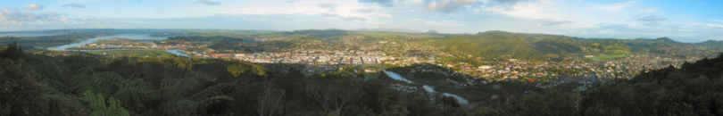
 Mt Parihaka is a volcanic dome rising 241 m to the northeast of the city centre. It is about 20 million years old, and part of the Harbour Fault which also includes Parakiore near Kamo
, and Hikurangi
near the town of the same name. The dome is surrounded by the Parihaka Scenic Reserve. There is road access to the summit of Parihaka, and walking tracks through the reserve.
The dome is frequently called Mount Parahaki, but the original Māori spelling of Parihaka was confirmed by the government in 2005.
, 6 km north of the city.
by the Friends of Matakohe/Limestone Island Society. There is public access by boat.
zone. It is the warmest and the northernmost city in NZ. Summer days occasionally exceed 30°C, and there is plentiful rainfall spread relatively evenly over the year.
Whangarei is roughly the antipodal point
of Tangier
, Morocco
.
competitions. They are based in Whangarei
. They currently compete in the Albert Baskerville Trophy as the Northern Swords. Between 2006 and 2007 they were part of the Bartercard Cup
, playing under the name the Northern Storm. Northland was originally known as North Auckland and has previously used the nickname the Wild Boars.
Whangarei is home to the Northland
rugby union team, a professional side competing in the ITM Cup, the highest level of provincial rugby in New Zealand. They play out of Okara Park
, the largest stadium in the region, which is also hosting two matches during Rugby World Cup 2011.
The football (soccer) club North Force
who compete in the Lotto Sport Italia NRFL Division 1
are based in Whangarei.
Whangarei also has an excellent Field Hockey
facility, often hosting international matches between the New Zealand
Black Sticks
and various international opposition.
Northland is also represented at the highest national domestic level in Golf
and Field Hockey
. Northland has had reasonable success in field hockey of late, with several players from Northland being selected for the Black Sticks
.
of 5 and cover years 9-13. Both schools opened in 1881.
Pompallier Catholic College
(opened in 1971) is a Catholic state integrated co-educational secondary school (years 7 to 13) with a roll of 560 and a decile ranking of 7.
Whangarei Intermediate is an intermediate (years 7-8) school with a roll of 639. Whangarei School is a contributing primary (years 1-6) school with a roll of 577.
Blomfield Special School and Resource Centre provides education and care to students between the ages of five and twenty-one years, and has a roll of 68. The school operates from five locations, four in Whangarei and one in Kaitaia
.
Christian Renewal School is a composite (years 1-15) school with a roll of 151. The school was established in 1993 and integrated into the state system in 1997. The school operates in the Christian Renewal Church buildings.
These four schools are all coeducational, and all have a decile rating of 4 except for the Christian Renewal School, which has a decile of 5.
Whangarei also has a technical institution, NorthTec
, with a comprehensive range of programs from certificate to degree level. The student body of NorthTec consists of around 23,000 students studying either part-time and full-time. The main campus is located in the suburb of Raumanga
.
New Zealand
New Zealand is an island country in the south-western Pacific Ocean comprising two main landmasses and numerous smaller islands. The country is situated some east of Australia across the Tasman Sea, and roughly south of the Pacific island nations of New Caledonia, Fiji, and Tonga...
and the regional capital of Northland Region. Although commonly classified as a city, it is officially part of the Whangarei District
Whangarei District
The Whangarei District is located in Northland, New Zealand. Whangarei is the principal town and the district seat. Other towns include Hukerenui, Hikurangi, Titoki, Ruakaka and Waipu...
, administered by the Whangarei District Council a local body created in 1989 to administer both the city proper and its hinterland. The population was estimated to be up from 47,400 in 2001.
The Whangarei urban area includes the suburbs of Kamo
Kamo, New Zealand
Kamo is a small township north of Whangarei, approximately five minutes drive from the Whangarei CBD. The name is a Māori word meaning "eyelash", but has also been said to mean "to bubble up", referring to hot springs in the area. Mount Parakiore is a volcanic dome rising 391 m to the northwest of...
, Tikipunga
Tikipunga
Tikipunga is one of the biggest suburbs in Whangarei, New Zealand. It is in the north-east part of the town and has the landmark Whangarei Falls nearby.The population was 6,114 in the 2006 Census, an increase of 450 from 2001.-Whangarei Falls:...
, Otangarei
Otangarei
Otangarei is a suburb of Whangarei, in Northland Region, New Zealand.Locals also refer to this area as O.T .The population was 2,256 in the 2006 Census, an increase of 225 from 2001.- Education :...
, Mairtown, Riverside, Sherwood Rise, Onerahi
Onerahi
Onerahi is a seaside suburb of Whangarei, New Zealand's northern most city. It is the city's only seaside suburb .It is located 9 km south-east of the centre of Whangarei, and follows the Whangarei harbour coastline until it meets the Pacific Ocean....
, Morningside, Raumanga
Raumanga
Raumanga is a suburb of Whangarei in the Northland Region of New Zealand. The main campus of Northland Polytechnic is situated in Raumanga.The population was 4,740 in the 2006 Census, an increase of 282 from 2001.-Education:...
, Parihaka, Maunu, Horahora
Horahora, Whangarei
Horahora is a suburb on the southwestern side of Whangarei, in Northland, New Zealand.The population was 1,026 in the 2006 Census, an increase of 45 from 2001.-Education:...
, Woodhill, Vinetown, The Regent, Kensington, and Whau Valley
Whau Valley
Whau Valley is a suburb of Whangarei, in Northland Region, New Zealand. State Highway 1 runs through it. The valley was named for the whau trees which grew there in the 1850s.The population was 2,745 in the 2006 Census, an increase of 81 from 2001....
.
History
Captain James CookJames Cook
Captain James Cook, FRS, RN was a British explorer, navigator and cartographer who ultimately rose to the rank of captain in the Royal Navy...
and the crew of the Endeavour
HM Bark Endeavour
HMS Endeavour, also known as HM Bark Endeavour, was a British Royal Navy research vessel commanded by Lieutenant James Cook on his first voyage of discovery, to Australia and New Zealand from 1769 to 1771....
were the first Europeans to contemplate the Whangarei Harbour entrance. On 15 November 1769 they caught about one hundred fish there which they classified as 'bream' (probably snapper
Lutjanidae
Snappers are a family of perciform fish, mainly marine but with some members inhabiting estuaries, feeding in freshwater. Some are important food fish. One of the best known is the red snapper....
) prompting Cook to name the area Bream Bay
Bream Bay
Bream Bay is a locality and bay on the east coast of New Zealand. Captain James Cook named this area to the bay itself, but also the some surrounding locations, stretching north to Whangarei and southbound touching Mangawhai....
.
The Māori iwi
Iwi
In New Zealand society, iwi form the largest everyday social units in Māori culture. The word iwi means "'peoples' or 'nations'. In "the work of European writers which treat iwi and hapū as parts of a hierarchical structure", it has been used to mean "tribe" , or confederation of tribes,...
Ngāpuhi
Ngapuhi
Ngāpuhi is a Māori iwi located in the Northland region of New Zealand, and centred in the Hokianga, the Bay of Islands and Whāngārei.Ngāpuhi has the largest affiliation of any New Zealand iwi, with 122,214 people registered , and formed from 150 hapu, with 55 marae.-Foundations:The founding...
occupied Whangarei from the early 19th century, and the Te Parawhau hapū
Hapu
A hapū is sometimes described as "the basic political unit within Maori society".A named division of a Māori iwi , membership is determined by genealogical descent; a hapū is made up of a number of whānau groups. Generally hapū range in size from 150-200 although there is no upper limit...
lived at the head of the harbour. In the 1820s the area was repeatedly attacked by Waikato
Waikato (iwi)
Waikato is a Māori iwi from the Waikato region of the North Island of New Zealand. Actually a confederation of smaller tribes, it is also part of the larger confederation of Tainui, consisting of tribes descended from Polynesian migrants who arrived in New Zealand on the Tainui canoe...
and Ngāti Paoa raiders during the Musket Wars
Musket Wars
The Musket Wars were a series of five hundred or more battles mainly fought between various hapū , sometimes alliances of pan-hapū groups and less often larger iwi of Māori between 1807 and 1842, in New Zealand.Northern tribes such as the rivals Ngāpuhi and Ngāti Whātua were the first to obtain...
.
The first European settler was William Carruth, a Scotsman and trader who arrived in 1839 and was joined, six years later, by Gilbert Mair
Gilbert Mair (trader)
Gilbert Mair was a sailor and a merchant trader who visited New Zealand for the first time when he was twenty, and lived there from 1824 till his death. He married Elizabeth Gilbert Puckey. They had twelve children. Among them were "famous New Zealanders" like Captain Gilbert Mair and Major...
and his family. For the most part, relations between the settlers and local Māori were friendly, but in February 1842, all settler farms were plundered in revenge for transgressions of tapu. In April 1845, during the Flagstaff War
Flagstaff War
The Flagstaff War – also known as Hone Heke's Rebellion, the Northern War and erroneously as the First Māori War – was fought between 11 March 1845 and 11 January 1846 in and around the Bay of Islands, New Zealand...
, all settlers fled from Whangarei. Most of the original settlers never returned, but by the mid 1850s there were a number of farmers and orchardists in the area. From 1855, a small town developed, driven by the kauri gum
Gum-digger
Kauri gum, a fossilized resin detracted from kauri trees, is used for chewing or tattooing, and often is made into jewellery. The gum comes from kauri trees found in Agathis australis forests. The trees once covered much of the New Zealand North Island, before Māori and European settlers caused...
trade. Today's 'Town Basin' on the Hātea River was the original port and early exports included kauri gum and native timber followed later by coal from Whau Valley
Whau Valley
Whau Valley is a suburb of Whangarei, in Northland Region, New Zealand. State Highway 1 runs through it. The valley was named for the whau trees which grew there in the 1850s.The population was 2,745 in the 2006 Census, an increase of 81 from 2001....
, Kamo
Kamo, New Zealand
Kamo is a small township north of Whangarei, approximately five minutes drive from the Whangarei CBD. The name is a Māori word meaning "eyelash", but has also been said to mean "to bubble up", referring to hot springs in the area. Mount Parakiore is a volcanic dome rising 391 m to the northwest of...
and Hikurangi
Hikurangi
Hikurangi is a settlement in Northland, New Zealand. The city of Whangarei is 17 km to the south, and Kawakawa is 39 km northwest. The Glenbervie Forest is southeast of the settlement. State Highway 1 once passed through the town, but now bypasses it to the west. Mount Hikurangi is a...
. Coal from the Kiripaka field was exported via the Ngunguru River. By 1864, the nucleus of the present city was established.
Fire bricks made from fire clay deposits near the Kamo mines supported a brick works over several decades. Good quality limestone was quarried at Hikurangi, Portland, and Limestone Island, and initially sold as agricultural lime and later combined with local coal to produce Portland cement at the settlement of Portland
Portland, Northland
Portland is a locality on the western side of Whangarei Harbour in Northland, New Zealand. Whangarei is about 10 km to the north. Tikorangi is a hill to the west with a summit 161 m above sea level....
on the south side of the harbour. Local limestone is still used in cement manufacture but the coal is now imported from the West Coast
West Coast, New Zealand
The West Coast is one of the administrative regions of New Zealand, located on the west coast of the South Island, and is one of the more remote and most sparsely populated areas of the country. It is made up of three districts: Buller, Grey and Westland...
of the South Island
South Island
The South Island is the larger of the two major islands of New Zealand, the other being the more populous North Island. It is bordered to the north by Cook Strait, to the west by the Tasman Sea, to the south and east by the Pacific Ocean...
.
Whangarei was the most urbanised area in Northland towards the end of the 19th century, but grew slowly in the 20th century. The district slowly exhausted most of its natural resources but was sustained by agriculture, especially dairying. Shipping was the main transport link until the North Auckland railway line reached the town in 1925, and the road from Auckland was not suitable for travel in poor weather until 1934. These terrestrial travel routes forced a rapid decline in coastal shipping but stimulated Whangarei to become the service centre for Northland. The population was 14,000 in 1945, but grew rapidly in the 1960s, incorporating Kamo
Kamo, New Zealand
Kamo is a small township north of Whangarei, approximately five minutes drive from the Whangarei CBD. The name is a Māori word meaning "eyelash", but has also been said to mean "to bubble up", referring to hot springs in the area. Mount Parakiore is a volcanic dome rising 391 m to the northwest of...
and other outlying areas. In 1965, Whangarei was declared a city. Its population the following year was 31,000.
The second half of the twentieth century brought the establishment and expansion of the oil refinery at Marsden Point
Marsden Point
Marsden Point is a head of the Whangarei Harbour, near Whangarei, New Zealand, lying close to the northern tip of Bream Bay. It is also a major industrial area, containing Marsden Point Oil Refinery, the country's only such facility, and two large defunct power plant stations...
on Bream Bay and the adjacent development of timber processing. A container port could follow, linked by rail to Auckland.
Geography
Mount Parihaka
Kamo, New Zealand
Kamo is a small township north of Whangarei, approximately five minutes drive from the Whangarei CBD. The name is a Māori word meaning "eyelash", but has also been said to mean "to bubble up", referring to hot springs in the area. Mount Parakiore is a volcanic dome rising 391 m to the northwest of...
, and Hikurangi
Hikurangi
Hikurangi is a settlement in Northland, New Zealand. The city of Whangarei is 17 km to the south, and Kawakawa is 39 km northwest. The Glenbervie Forest is southeast of the settlement. State Highway 1 once passed through the town, but now bypasses it to the west. Mount Hikurangi is a...
near the town of the same name. The dome is surrounded by the Parihaka Scenic Reserve. There is road access to the summit of Parihaka, and walking tracks through the reserve.
The dome is frequently called Mount Parahaki, but the original Māori spelling of Parihaka was confirmed by the government in 2005.
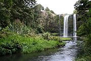
Hātea River
The Hātea River flows south through the city and empties into Whangarei Harbour. The river has a spectacular 26 m waterfall in TikipungaTikipunga
Tikipunga is one of the biggest suburbs in Whangarei, New Zealand. It is in the north-east part of the town and has the landmark Whangarei Falls nearby.The population was 6,114 in the 2006 Census, an increase of 450 from 2001.-Whangarei Falls:...
, 6 km north of the city.
Matakohe/Limestone Island
Matakoe, or Limestone Island, lies in the harbour close to the city. Owned by Whangarei District, it is subject to ecological island restorationIsland restoration
The ecological restoration of islands, or island restoration, is the application of the principles of ecological restoration to islands and island groups. Islands, due to their isolation, are home to many of the world's endemic species, as well as important breeding grounds for seabirds and some...
by the Friends of Matakohe/Limestone Island Society. There is public access by boat.
Climate
Whangarei falls in the oceanic climateOceanic climate
An oceanic climate, also called marine west coast climate, maritime climate, Cascadian climate and British climate for Köppen climate classification Cfb and subtropical highland for Köppen Cfb or Cwb, is a type of climate typically found along the west coasts at the middle latitudes of some of the...
zone. It is the warmest and the northernmost city in NZ. Summer days occasionally exceed 30°C, and there is plentiful rainfall spread relatively evenly over the year.
Whangarei is roughly the antipodal point
Antipodal point
In mathematics, the antipodal point of a point on the surface of a sphere is the point which is diametrically opposite to it — so situated that a line drawn from the one to the other passes through the centre of the sphere and forms a true diameter....
of Tangier
Tangier
Tangier, also Tangiers is a city in northern Morocco with a population of about 700,000 . It lies on the North African coast at the western entrance to the Strait of Gibraltar where the Mediterranean meets the Atlantic Ocean off Cape Spartel...
, Morocco
Morocco
Morocco , officially the Kingdom of Morocco , is a country located in North Africa. It has a population of more than 32 million and an area of 710,850 km², and also primarily administers the disputed region of the Western Sahara...
.
Sports
The Northland rugby league team are a rugby league team that represents the Northland Region in New Zealand Rugby LeagueNew Zealand Rugby League
The New Zealand Rugby League is the governing body for the sport of rugby league football in New Zealand. The NZRL was founded on the 25 April 1910 in preparation for a tour of Great Britain that same year....
competitions. They are based in Whangarei
Whangarei
Whangarei, pronounced , is the northernmost city in New Zealand and the regional capital of Northland Region. Although commonly classified as a city, it is officially part of the Whangarei District, administered by the Whangarei District Council a local body created in 1989 to administer both the...
. They currently compete in the Albert Baskerville Trophy as the Northern Swords. Between 2006 and 2007 they were part of the Bartercard Cup
Bartercard Cup
The Bartercard Cup was the top level rugby league club competition in New Zealand from 2000 until 2007. For the entire life of the tournament it was sponsored by Bartercard. The cup was administered by the New Zealand Rugby League...
, playing under the name the Northern Storm. Northland was originally known as North Auckland and has previously used the nickname the Wild Boars.
Whangarei is home to the Northland
Northland Rugby Union
The Northland Rugby Football Union is the governing body of rugby union in the Northland region of New Zealand.-History:Rugby was first played in Northland in the 1870s, and the first union was set up in the province in 1895, known as the Marsden Football Union. The Northland union was founded in...
rugby union team, a professional side competing in the ITM Cup, the highest level of provincial rugby in New Zealand. They play out of Okara Park
Okara Park
Okara Park is a multi-purpose stadium in Whangarei, New Zealand. It is currently used mostly for rugby union matches and is the home stadium of Northland Rugby Union. The stadium is able to hold 30,000 people and was built in 1965....
, the largest stadium in the region, which is also hosting two matches during Rugby World Cup 2011.
The football (soccer) club North Force
North Force
North Force is a football club based in the Whangarei, New Zealand. They compete in the Lotto Sport Italia NRFL Division 1.North Force was set up late in 2003 by Kamo & Tikipunga Football clubs so that a combined team could be entered in either the US1 Federation League or the Northern Federations...
who compete in the Lotto Sport Italia NRFL Division 1
Lotto Sport Italia NRFL Division 1
The Lotto Sport Italia NRFL Division 1 is a New Zealand Association football semi-professional status league competition that is run by the Auckland Football Federation and includes soccer clubs located in the northern part of the North Island, New Zealand...
are based in Whangarei.
Whangarei also has an excellent Field Hockey
Field hockey
Field Hockey, or Hockey, is a team sport in which a team of players attempts to score goals by hitting, pushing or flicking a ball into an opposing team's goal using sticks...
facility, often hosting international matches between the New Zealand
New Zealand
New Zealand is an island country in the south-western Pacific Ocean comprising two main landmasses and numerous smaller islands. The country is situated some east of Australia across the Tasman Sea, and roughly south of the Pacific island nations of New Caledonia, Fiji, and Tonga...
Black Sticks
Black Sticks
The Black Sticks Men are New Zealand's men's national field hockey team. They upset Australia to win gold at the 1976 Summer Olympics in Montreal, becoming the first non-Asian/European team to clinch the gold.-Summer Olympics:*1956 – Sixth place...
and various international opposition.
Northland is also represented at the highest national domestic level in Golf
Golf
Golf is a precision club and ball sport, in which competing players use many types of clubs to hit balls into a series of holes on a golf course using the fewest number of strokes....
and Field Hockey
Field hockey
Field Hockey, or Hockey, is a team sport in which a team of players attempts to score goals by hitting, pushing or flicking a ball into an opposing team's goal using sticks...
. Northland has had reasonable success in field hockey of late, with several players from Northland being selected for the Black Sticks
Black Sticks Women
The Black Sticks Women are the women's national field hockey team of New Zealand.-Summer Olympics:*1980 – Did not compete*1984 – Sixth place*1988 – Did not compete*1992 – Eighth place*1996 – Did not compete*2000 – Sixth place...
.
Education
Whangarei Boys' High School is a boys' secondary school with a roll of 1060. Whangarei Girls' High School is a girls' secondary school with a roll of 1127. These two secondary schools have a decile ratingSocio-Economic Decile
Decile, Socio-Economic Decile or Socio-Economic Decile Band is a widely used measure in education in New Zealand used to target funding and support to more needy schools....
of 5 and cover years 9-13. Both schools opened in 1881.
Pompallier Catholic College
Pompallier Catholic College
Pompallier Catholic College is a Catholic co-educational Secondary college located in the suburb of Maunu in Whangarei, New Zealand.-Mission statement:The Mission of Pompallier Catholic College is Learning Excellence for Life-Vision:...
(opened in 1971) is a Catholic state integrated co-educational secondary school (years 7 to 13) with a roll of 560 and a decile ranking of 7.
Whangarei Intermediate is an intermediate (years 7-8) school with a roll of 639. Whangarei School is a contributing primary (years 1-6) school with a roll of 577.
Blomfield Special School and Resource Centre provides education and care to students between the ages of five and twenty-one years, and has a roll of 68. The school operates from five locations, four in Whangarei and one in Kaitaia
Kaitaia
Kaitaia is a town in the far north region of New Zealand, at the base of the Aupouri Peninsula which is about 160 km northwest of Whangarei. It is the last major settlement on the main road north to the capes and bays on the peninsula...
.
Christian Renewal School is a composite (years 1-15) school with a roll of 151. The school was established in 1993 and integrated into the state system in 1997. The school operates in the Christian Renewal Church buildings.
These four schools are all coeducational, and all have a decile rating of 4 except for the Christian Renewal School, which has a decile of 5.
Whangarei also has a technical institution, NorthTec
NorthTec
NorthTec is the largest tertiary education provider in northern New Zealand. NorthTec is the only Northland-based Tertiary Education Institute that provides programmes ranging from foundation, certificate, diploma and degree levels....
, with a comprehensive range of programs from certificate to degree level. The student body of NorthTec consists of around 23,000 students studying either part-time and full-time. The main campus is located in the suburb of Raumanga
Raumanga
Raumanga is a suburb of Whangarei in the Northland Region of New Zealand. The main campus of Northland Polytechnic is situated in Raumanga.The population was 4,740 in the 2006 Census, an increase of 282 from 2001.-Education:...
.
Notable people
- Laurence ClarkLaurence ClarkLaurence Clark is a New Zealand cartoonist and illustrator.He started his career in illustration in 1967 at the New Zealand Herald. He was the political cartoonist there from 1987 to 1996 and now freelances from Northland. He publishes his cartoons under the name of "Klarc".-External links:* -...
, cartoonist. - Keith UrbanKeith UrbanKeith Lionel Urban is a New Zealand-born Australian, country music singer, songwriter and guitarist whose commercial success has been mainly in the United States and Australia. Urban was born in New Zealand and began his career in Australia at an early age...
, country music singer - Tim Southee, New Zealand cricketerCricketerA cricketer is a person who plays the sport of cricket. Official and long-established cricket publications prefer the traditional word "cricketer" over the rarely used term "cricket player"....
- Adam BlairAdam BlairAdam Blair is a New Zealand professional rugby league footballer currently contracted to the Melbourne Storm of the National Rugby League until 1 November 2011, when he will join the Wests Tigers. A New Zealand international representative forward, Blair spent six seasons with the Storm, winning...
, New Zealand Rugby LeagueRugby leagueRugby league football, usually called rugby league, is a full contact sport played by two teams of thirteen players on a rectangular grass field. One of the two codes of rugby football, it originated in England in 1895 by a split from Rugby Football Union over paying players...
representative - Michael HillMichael Hill (entrepreneur)Sir Michael Hill, KNZM is a New Zealand jeweller, entrepreneur and philanthropist who founded global jewellery retailer Michael Hill Jeweller in 1979 and continues to serve as its chairman...
, jeweller