
List of National Historic Sites of Canada in Alberta
Encyclopedia
This is a list of National Historic Sites of Canada in the province
of Alberta
. There are 59 National Historic Sites designated in Alberta, of which 14 are administered by Parks Canada
. The first three sites in Alberta were designated in 1923 and are as follows: the site of rival trading posts Fort Augustus and Fort Edmonton
, the site of the Frog Lake Massacre
and the site of the first outpost of the North-West Mounted Police in Western Canada
at Fort MacLeod
.
This list uses names designated by the Historic Sites and Monuments Board of Canada, which may differ from other names for these sites.
Provinces and territories of Canada
The provinces and territories of Canada combine to make up the world's second-largest country by area. There are ten provinces and three territories...
of Alberta
Alberta
Alberta is a province of Canada. It had an estimated population of 3.7 million in 2010 making it the most populous of Canada's three prairie provinces...
. There are 59 National Historic Sites designated in Alberta, of which 14 are administered by Parks Canada
Parks Canada
Parks Canada , also known as the Parks Canada Agency , is an agency of the Government of Canada mandated to protect and present nationally significant natural and cultural heritage, and foster public understanding, appreciation, and enjoyment in ways that ensure their ecological and commemorative...
. The first three sites in Alberta were designated in 1923 and are as follows: the site of rival trading posts Fort Augustus and Fort Edmonton
Fort Edmonton
Fort Edmonton was the name of a series of trading posts of the Hudson's Bay Company from 1795 to 1891, all of which were located in central Alberta, Canada...
, the site of the Frog Lake Massacre
Frog Lake Massacre
The Frog Lake Massacre was a Cree uprising during the North-West Rebellion in western Canada. Led by Wandering Spirit, young Cree warriors attacked the village of Frog Lake, North-West Territories on 2 April 1885, where they killed nine settlers.- Causes :Angered by what seemed to be unfair...
and the site of the first outpost of the North-West Mounted Police in Western Canada
Western Canada
Western Canada, also referred to as the Western provinces and commonly as the West, is a region of Canada that includes the four provinces west of the province of Ontario.- Provinces :...
at Fort MacLeod
Fort Macleod, Alberta
Fort Macleod is a town in the southwest corner of the province of Alberta, Canada. It was founded as a North-West Mounted Police barracks, and is named in honour of the North-West Mounted Police Colonel James Macleod. The town's current mayor is Shawn Patience.- History and heritage preservation...
.
This list uses names designated by the Historic Sites and Monuments Board of Canada, which may differ from other names for these sites.
National Historic Sites
| Site | Date(s) | Designated | Location | Description | Image |
|---|---|---|---|---|---|
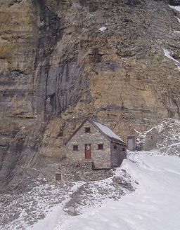
| Abbot Pass Refuge Cabin Abbot Pass hut The Abbot Pass hut is an alpine hut located at an altitude of 2925 metres in Abbot Pass in the Rocky Mountains in Alberta, Canada. It is nestled between Mount Victoria and Mount Lefroy, straddling the continental divide, which, in this region, defines the boundary between Banff National Park in... |
1922 (completed) | 1992 | Abbot Pass Abbot Pass Abbot Pass lies between Mount Lefroy and Mount Victoria, in the divide between the valleys of Lake O'Hara and Lake Louise. It was named for Phillip Stanley Abbot who died in 1896 in an attempt to climb Mount Lefroy with Charles Fay, Charles Thompson, and George T... 51°21′50.598"N 116°17′24.7488"W |
An alpine hut located at an elevation of 2925 metres in the Alberta Rockies Alberta's Rockies Alberta's Rockies comprises the Canadian Rockies in the province of Alberta, Canada. It is a region on the southwestern part of the province, along the British Columbia border. It covers all but the south of Census Division 15.... , near the continental divide Continental divide A continental divide is a drainage divide on a continent such that the drainage basin on one side of the divide feeds into one ocean or sea, and the basin on the other side either feeds into a different ocean or sea, or else is endorheic, not connected to the open sea... in Banff National Park Banff National Park Banff National Park is Canada's oldest national park, established in 1885 in the Rocky Mountains. The park, located 110–180 kilometres west of Calgary in the province of Alberta, encompasses of mountainous terrain, with numerous glaciers and ice fields, dense coniferous forest, and alpine... , near its boundary with Yoho National Park Yoho National Park Yoho National Park is located in the Canadian Rocky Mountains along the western slope of the Continental Divide in southeastern British Columbia. Yoho NP is bordered by Kootenay National Park on the southern side and Banff National Park on the eastern side... in British Columbia British Columbia British Columbia is the westernmost of Canada's provinces and is known for its natural beauty, as reflected in its Latin motto, Splendor sine occasu . Its name was chosen by Queen Victoria in 1858... |
 |
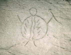
| Áísínai'pi Writing-on-Stone Provincial Park Writing-on-Stone Provincial Park is located about 100 kilometres southeast of Lethbridge, Alberta, Canada or 44 kilometres east of the community of Milk River, and straddles the Milk River itself. It is one of the largest areas of protected prairie in the Alberta park system, and serves as both a... |
2004 | Milk River Milk River, Alberta Milk River is a town in the province of Alberta, Canada, located on and named after the Milk River, which flows immediately to its south. It is south of Lethbridge, and from the Canada-U.S. border. It is primarily a service centre for the many farms and cattle ranches which surround... 49°4′55"N 111°37′1"W |
Also known as Writing-on-Stone Provincial Park Writing-on-Stone Provincial Park Writing-on-Stone Provincial Park is located about 100 kilometres southeast of Lethbridge, Alberta, Canada or 44 kilometres east of the community of Milk River, and straddles the Milk River itself. It is one of the largest areas of protected prairie in the Alberta park system, and serves as both a... , it serves as both a nature preserve and protection for a large number of aboriginal Aboriginal peoples in Canada Aboriginal peoples in Canada comprise the First Nations, Inuit and Métis. The descriptors "Indian" and "Eskimo" have fallen into disuse in Canada and are commonly considered pejorative.... rock carvings and paintings |
 |
|
| Athabasca Pass Athabasca Pass Athabasca Pass is a high mountain pass in the Canadian Rockies. It is the headwaters of the Whirlpool River, a tributary of the Athabasca River.The pass lies between Mount Brown and McGillivray Ridge... |
1811 (first documented by non-Aboriginal people) | 1971 | Jasper National Park Jasper National Park Jasper National Park is the largest national park in the Canadian Rockies, spanning 10,878 km² . It is located in the province of Alberta, north of Banff National Park and west of the City of Edmonton. The park includes the glaciers of the Columbia Icefield, hot springs, lakes, waterfalls and... 52°22′35"N 118°11′00"W |
A major point on the fur trade Fur trade The fur trade is a worldwide industry dealing in the acquisition and sale of animal fur. Since the establishment of world market for in the early modern period furs of boreal, polar and cold temperate mammalian animals have been the most valued... route between Rupert's Land Rupert's Land Rupert's Land, or Prince Rupert's Land, was a territory in British North America, consisting of the Hudson Bay drainage basin that was nominally owned by the Hudson's Bay Company for 200 years from 1670 to 1870, although numerous aboriginal groups lived in the same territory and disputed the... and the Columbia District Columbia District The Columbia District was a fur trading district in the Pacific Northwest region of British North America in the 19th century. It was explored by the North West Company between 1793 and 1811, and established as an operating fur district around 1810... , used by the York Factory Express York Factory Express The York Factory Express, usually called "the Express" and also called the Columbia Express and the Communication, was a brigade operated by Hudson's Bay Company in the early 19th century connecting York Factory and Fort Vancouver. It was named "express" because it was not used only to transport... |
|
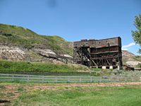
| Atlas No. 3 Coal Mine Atlas Coal Mine The Atlas Coal Mine is a former coal mine in Alberta, Canada. Located in East Coulee, it is home to the last standing wooden tipple in Canada. It was designated a National Historic Site of Canada in 1989.-History:... |
1936 (opened) | 2001 | Drumheller Drumheller, Alberta Drumheller is a town within the Red Deer River valley in the badlands of east-central Alberta, Canada. It is located northeast of Calgary... 51.32863°N 112.48251°W |
An exceptionally well-preserved coal-mining Coal mining The goal of coal mining is to obtain coal from the ground. Coal is valued for its energy content, and since the 1880s has been widely used to generate electricity. Steel and cement industries use coal as a fuel for extraction of iron from iron ore and for cement production. In the United States,... landscape |
 |
| Banff Park Museum Banff Park Museum The Banff Park Museum National Historic Site, located in downtown Banff, Alberta, is an exhibition space associated with Banff National Park. The museum was established in 1895 to house an exhibit of mounted specimens of animals, plants and minerals associated with the park... |
1903 (completed) | 1985 | Banff National Park Banff National Park Banff National Park is Canada's oldest national park, established in 1885 in the Rocky Mountains. The park, located 110–180 kilometres west of Calgary in the province of Alberta, encompasses of mountainous terrain, with numerous glaciers and ice fields, dense coniferous forest, and alpine... 51°10′25.57"N 115°34′17.9"W |
A rustic log Logging Logging is the cutting, skidding, on-site processing, and loading of trees or logs onto trucks.In forestry, the term logging is sometimes used in a narrow sense concerning the logistics of moving wood from the stump to somewhere outside the forest, usually a sawmill or a lumber yard... -faced building set prominently within a landscaped park in the Banff townsite Banff, Alberta Banff is a town within Banff National Park in Alberta, Canada. It is located in Alberta's Rockies along the Trans-Canada Highway, approximately west of Calgary and east of Lake Louise.... , containing early botanical Botany Botany, plant science, or plant biology is a branch of biology that involves the scientific study of plant life. Traditionally, botany also included the study of fungi, algae and viruses... and zoological Zoology Zoology |zoölogy]]), is the branch of biology that relates to the animal kingdom, including the structure, embryology, evolution, classification, habits, and distribution of all animals, both living and extinct... exhibits from Banff National Park in early twentieth-century glass cases |
|
| Banff Springs Hotel Banff Springs Hotel The Fairmont Banff Springs or simply the Banff Springs Hotel is a former railway hotel constructed in Scottish Baronial style located in Banff National Park, Alberta, Canada. The original hotel, designed by American architect Bruce Price, was built between spring of 1887 and 1888 by the Canadian... |
1928 (completed) | 1988 | Banff National Park Banff National Park Banff National Park is Canada's oldest national park, established in 1885 in the Rocky Mountains. The park, located 110–180 kilometres west of Calgary in the province of Alberta, encompasses of mountainous terrain, with numerous glaciers and ice fields, dense coniferous forest, and alpine... 51°09′52.2"N 115°33′47.7"W |
A former railway hotel Canada's grand railway hotels Canada’s railway hotels are a series of grand hotels across the country, each a local and national landmark, and most of which are icons of Canadian history and architecture. Each hotel was originally built by the Canadian railway companies, or the railways acted as a catalyst for the hotel’s... constructed in Scottish Baronial style at the base of Sulphur Mountain, built to replace a wooden 1888 hotel which burned down in 1926 |
|
| Bar U Ranch Bar U Ranch The Bar U Ranch National Historic Site, located near Longview, Alberta, is a preserved ranch that for 70 years was one of the leading ranching operations in Canada. At its peak, the ranch extended over with 30,000 cattle and 1000 Percheron horses... |
1882 (established) | 1989 | Longview Longview, Alberta Longview is a village in southern Alberta, Canada. It is located in the Canadian Rockies foothills, on Cowboy Trail, 32 km west of High River and 64 km south of Calgary... 50°25′11"N 114°14′0"W |
A historic ranch in the Alberta foothills | |
| Beaulieu Lougheed House Built in 1891 and originally known as "Beaulieu", the French meaning "beautiful place", Lougheed House is now a national historic site located in the Beltline district of Calgary, Alberta... |
1891 (completed) | 1992 | Calgary Calgary Calgary is a city in the Province of Alberta, Canada. It is located in the south of the province, in an area of foothills and prairie, approximately east of the front ranges of the Canadian Rockies... 51.04043°N 114.07835°W |
Known as Lougheed House, a mansion in Calgary's Beltline district originally built for Senator James Alexander Lougheed James Alexander Lougheed Sir James Alexander Lougheed, KCMG, PC, QC was a businessman and politician from Alberta, Canada.-Early Life:Lougheed was born in Brampton, Canada West, to Irish Protestant parents. The family moved to Weston, Canada West , when Lougheed was a child, and he attended King Street Public School Sir... |
|
| Blackfoot Crossing Blackfoot Crossing Blackfoot Crossing Historical Park is a complex of historic sites on the Siksika 146 Indian reserve in Alberta, Canada. This crossing of the Bow River was traditionally a bison-hunting and gathering place for the Siksika people and their allies in the Blackfoot Confederacy... |
1925 | Traditional meeting place on Blackfoot Blackfoot The Blackfoot Confederacy or Niitsítapi is the collective name of three First Nations in Alberta and one Native American tribe in Montana.... reserve |
|||
| British Block Cairn | 1400 CE Common Era Common Era ,abbreviated as CE, is an alternative designation for the calendar era originally introduced by Dionysius Exiguus in the 6th century, traditionally identified with Anno Domini .Dates before the year 1 CE are indicated by the usage of BCE, short for Before the Common Era Common Era... (ca.) |
1973 | Canadian Forces Base Suffield CFB Suffield Canadian Forces Base Suffield , is the largest Canadian Forces Base and the largest Commonwealth military training base in the world... |
A large boulder cairn Cairn Cairn is a term used mainly in the English-speaking world for a man-made pile of stones. It comes from the or . Cairns are found all over the world in uplands, on moorland, on mountaintops, near waterways and on sea cliffs, and also in barren desert and tundra areas... surrounded by a ring of stones, an important example of Niitsitapi Blackfoot The Blackfoot Confederacy or Niitsítapi is the collective name of three First Nations in Alberta and one Native American tribe in Montana.... cultural heritage |
|
| Brooks Aqueduct Brooks Aqueduct The Brooks Aqueduct is a now defunct aqueduct built by the irrigation division of the Canadian Pacific Railway Company during the 1910s. The aqueduct stands approximately 8 kilometres south of the town of Brooks, Alberta.- Overview :... |
1914 (completed) | 1983 | Brooks Brooks, Alberta Brooks is a city in southeast Alberta, Canada surrounded by the County of Newell. It is located on Highway 1 and the Canadian Pacific Railway, approximately southeast of Calgary, and northwest of Medicine Hat. The city has an elevation of .- History :The area that is now Brooks was originally... 50.5289°N 111.8550°W |
A landmark irrigation Irrigation Irrigation may be defined as the science of artificial application of water to the land or soil. It is used to assist in the growing of agricultural crops, maintenance of landscapes, and revegetation of disturbed soils in dry areas and during periods of inadequate rainfall... project built by the Canadian Pacific Railway Canadian Pacific Railway The Canadian Pacific Railway , formerly also known as CP Rail between 1968 and 1996, is a historic Canadian Class I railway founded in 1881 and now operated by Canadian Pacific Railway Limited, which began operations as legal owner in a corporate restructuring in 2001... , spanning a 3.2 kilometer valley and irrigating a section of south-eastern Alberta |
|
| Calgary City Hall | 1911 (completed) | 1984 | Calgary Calgary Calgary is a city in the Province of Alberta, Canada. It is located in the south of the province, in an area of foothills and prairie, approximately east of the front ranges of the Canadian Rockies... |
A four-storey sandstone Sandstone Sandstone is a sedimentary rock composed mainly of sand-sized minerals or rock grains.Most sandstone is composed of quartz and/or feldspar because these are the most common minerals in the Earth's crust. Like sand, sandstone may be any colour, but the most common colours are tan, brown, yellow,... building with central clock tower, designed in the Romanesque Revival Romanesque Revival architecture Romanesque Revival is a style of building employed beginning in the mid 19th century inspired by the 11th and 12th century Romanesque architecture... style and serving as the focal point of Calgary's city hall complex |
|
| Cave and Basin Cave and Basin National Historic Site The Cave and Basin National Historic Site of Canada is located in the town of Banff, Alberta within the Canadian Rocky Mountains, at the site of natural thermal mineral springs around which Canada's first national park, Banff National Park, was established.... |
1859 (first documented by non-Aboriginal people) | 1981 | Banff National Park Banff National Park Banff National Park is Canada's oldest national park, established in 1885 in the Rocky Mountains. The park, located 110–180 kilometres west of Calgary in the province of Alberta, encompasses of mountainous terrain, with numerous glaciers and ice fields, dense coniferous forest, and alpine... 51.1700°N 115.5891°W |
The site of natural thermal mineral springs Hot spring A hot spring is a spring that is produced by the emergence of geothermally heated groundwater from the Earth's crust. There are geothermal hot springs in many locations all over the crust of the earth.-Definitions:... around which Canada's first national park, Banff National Park, was established |
|
| Coleman Coleman, Alberta Coleman is an urban community in the Rocky Mountains within the Municipality of Crowsnest Pass in southwest Alberta, Canada. It was formerly incorporated as a town prior to 1979 when it amalgamated with four other municipalities to form Crowsnest Pass.... |
1903 (establishment of townsite) | 2001 | Crowsnest Pass (municipality) Crowsnest Pass, Alberta The Municipality of Crowsnest Pass is a specialized municipality located in the Crowsnest Pass of the Rocky Mountains in southwest Alberta, Canada. The municipality formed as a result of the amalgamation of five municipalities – the Village of Bellevue, the Town of Blairmore, Town of Coleman, the... |
A preserved coal-mining Coal mining The goal of coal mining is to obtain coal from the ground. Coal is valued for its energy content, and since the 1880s has been widely used to generate electricity. Steel and cement industries use coal as a fuel for extraction of iron from iron ore and for cement production. In the United States,... landscape in one of the most important coal producing centres in the Crowsnest Pass Crowsnest Pass Crowsnest Pass is a high mountain pass across the Continental Divide of the Canadian Rockies on the Alberta/British Columbia border.-Geography:... , the greatest coalfield in Alberta and southeastern British Columbia |
|
| Earthlodge Village | 1972 | Gleichen Gleichen, Alberta Gleichen is a hamlet in southeast Alberta, Canada within Wheatland County. It is located adjacent to the Siksika Nation at the intersection of Highway 1 and Highway 547, approximately southeast of Strathmore.- History :... |
Remains of an Aboriginal village | ||
| First Oil Well in Western Canada First Oil Well in Western Canada The First Oil Well in Western Canada National Historic Site of Canada commemorates the 1902 oil strike in what is now Waterton Lakes National Park, Alberta... |
1902 | 1965 | Waterton Lakes National Park Waterton Lakes National Park Waterton Lakes National Park is a national park located in the southwest corner of Alberta, Canada, and borders Glacier National Park in Montana, USA. Waterton was Canada's fourth national park, formed in 1895 and named after Waterton Lake, in turn after the Victorian naturalist and conservationist... 49.070980°N 113.986770°W |
First commercially productive oil well Oil well An oil well is a general term for any boring through the earth's surface that is designed to find and acquire petroleum oil hydrocarbons. Usually some natural gas is produced along with the oil. A well that is designed to produce mainly or only gas may be termed a gas well.-History:The earliest... in Western Canada |
|
| Fort Assiniboine | 1823 (fort established) | 1935 | Woodlands County Woodlands County, Alberta Woodlands County is a municipal district in north-central Alberta, Canada.It is located in Census Division 13. The municipal seat is in the Town of Whitecourt, while a regional administrative office is also located in the Hamlet of Fort Assiniboine.... |
A trading post established by the Hudson's Bay Company Hudson's Bay Company The Hudson's Bay Company , abbreviated HBC, or "The Bay" is the oldest commercial corporation in North America and one of the oldest in the world. A fur trading business for much of its existence, today Hudson's Bay Company owns and operates retail stores throughout Canada... which served as a stopping point along the Klondike Trail |
|
| Fort Augustus and Fort Edmonton Fort Edmonton Fort Edmonton was the name of a series of trading posts of the Hudson's Bay Company from 1795 to 1891, all of which were located in central Alberta, Canada... |
1795 (Fort Augustus built), 1796 (first Fort Edmonton built) | 1923 | Fort Saskatchewan | The site of rival trading posts established by the North West Company North West Company The North West Company was a fur trading business headquartered in Montreal from 1779 to 1821. It competed with increasing success against the Hudson's Bay Company in what was to become Western Canada... and the Hudson's Bay Company Hudson's Bay Company The Hudson's Bay Company , abbreviated HBC, or "The Bay" is the oldest commercial corporation in North America and one of the oldest in the world. A fur trading business for much of its existence, today Hudson's Bay Company owns and operates retail stores throughout Canada... , described as being a "musket-shot" apart |
|
| Fort Calgary Fort Calgary Fort Calgary was established in 1875 as Fort Brisebois by the North-West Mounted Police, located at the confluence of the Bow and Elbow rivers in what is now Calgary, Alberta.-History:... |
1875 (established) | 1925 | Calgary Calgary Calgary is a city in the Province of Alberta, Canada. It is located in the south of the province, in an area of foothills and prairie, approximately east of the front ranges of the Canadian Rockies... |
A fort established by the North-West Mounted Police, located at the confluence of the Bow Bow River The Bow River is a river in the Canadian province of Alberta. It is a tributary of the South Saskatchewan River, and is considered the headwater of the Nelson River.... and Elbow Elbow River The Elbow River is a river located in southern Alberta, Canada. It flows from the Canadian Rockies to the city of Calgary, where it merges into the Bow River.... rivers in what is now Calgary |
|
| Fort Chipewyan Fort Chipewyan, Alberta Fort Chipewyan, commonly referred to as Fort Chip, is a hamlet in northern Alberta, Canada within the Regional Municipality of Wood Buffalo. It is located on the western tip of Lake Athabasca, adjacent to Wood Buffalo National Park, approximately north of Fort McMurray.Fort Chipewyan is one of... |
1788 (established) | 1930 | Wood Buffalo Wood Buffalo, Alberta The Regional Municipality of Wood Buffalo is a specialized municipality located in northeastern Alberta. Formed as a result of the amalgamation of the City of Fort McMurray and Improvement District No. 143 on April 1, 1995, it is the second largest municipality in Alberta by area... 58°42′44"N 111°08′54"W |
One of the oldest Europe Europe Europe is, by convention, one of the world's seven continents. Comprising the westernmost peninsula of Eurasia, Europe is generally 'divided' from Asia to its east by the watershed divides of the Ural and Caucasus Mountains, the Ural River, the Caspian and Black Seas, and the waterways connecting... an settlements in Alberta, established by the North West Company North West Company The North West Company was a fur trading business headquartered in Montreal from 1779 to 1821. It competed with increasing success against the Hudson's Bay Company in what was to become Western Canada... when it built a trading post Trading post A trading post was a place or establishment in historic Northern America where the trading of goods took place. The preferred travel route to a trading post or between trading posts, was known as a trade route.... there in 1788 |
|
| Fort Dunvegan | 1805 (established) | 1947 | Dunvegan Dunvegan, Alberta Dunvegan is an unincorporated community within the Municipal District of Fairview No. 136 in northern Alberta, Canada. It is located south of the town of Fairview on the northern bank of the Peace River at the mouth of the Dunvegan Creek.... |
Site of a trading post Trading post A trading post was a place or establishment in historic Northern America where the trading of goods took place. The preferred travel route to a trading post or between trading posts, was known as a trade route.... established by the North-West Mounted Police |
|
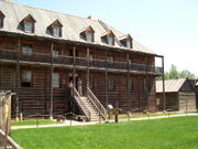
| Fort Edmonton III Fort Edmonton Fort Edmonton was the name of a series of trading posts of the Hudson's Bay Company from 1795 to 1891, all of which were located in central Alberta, Canada... |
1830 (established) | 1959 | Edmonton Edmonton Edmonton is the capital of the Canadian province of Alberta and is the province's second-largest city. Edmonton is located on the North Saskatchewan River and is the centre of the Edmonton Capital Region, which is surrounded by the central region of the province.The city and its census... 53.533714°N 113.506531°W |
The final Hudson's Bay Company Hudson's Bay Company The Hudson's Bay Company , abbreviated HBC, or "The Bay" is the oldest commercial corporation in North America and one of the oldest in the world. A fur trading business for much of its existence, today Hudson's Bay Company owns and operates retail stores throughout Canada... fort to bear the "Fort Edmonton" name, evolved into present-day Edmonton; reconstructed commencing in 1969 Fort Edmonton Park Fort Edmonton Park is an attraction in Edmonton, Alberta, Canada. Named for the first enduring European post in the area of modern-day Edmonton, the park is the largest living history museum in Canada by area... |
 |
| Fort Fork Fort Fork Fort Fork a North West Company trading post on the Peace River, established in 1792. In May 1793, Alexander Mackenzie wintered there. The fort was used until the NWC merged with the XY Company in 1805, after which it was replaced by Fort Dunvegan, further upstream.The fort was located southwest... |
1928 | Peace River Peace River, Alberta Peace River is a town in northwestern Alberta, Canada, situated along the banks of the Peace River, at its confluence with the Smoky River, the Heart River and Pat's Creek. It is located northwest of Edmonton, and northeast of Grande Prairie, along Highway 2. The Peace River townsite is nearly ... |
Starting point of Alexander MacKenzie's route to Pacific, 1793 | ||
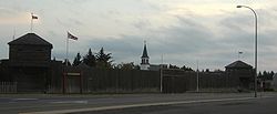
| Fort Macleod Fort Macleod, Alberta Fort Macleod is a town in the southwest corner of the province of Alberta, Canada. It was founded as a North-West Mounted Police barracks, and is named in honour of the North-West Mounted Police Colonel James Macleod. The town's current mayor is Shawn Patience.- History and heritage preservation... |
1874 (established) | 1923 | Fort Macleod Fort Macleod, Alberta Fort Macleod is a town in the southwest corner of the province of Alberta, Canada. It was founded as a North-West Mounted Police barracks, and is named in honour of the North-West Mounted Police Colonel James Macleod. The town's current mayor is Shawn Patience.- History and heritage preservation... 49°43′32.1"N 113°23′51.1"W |
A fort established in 1874 on an island on the Oldman River Oldman River The Oldman River is a river in southern Alberta, Canada. It flows roughly west to east from the Rocky Mountains, through the communities of Fort Macleod, Lethbridge, Taber, and on to Grassy Lake, where it joins with the Bow River to form the South Saskatchewan River, which eventually drains into... , it was the first outpost of the North-West Mounted Police in Western Canada, and served as NWMP headquarters between 1874 and 1878 |
 |
| Fort Vermilion Fort Vermilion, Alberta Fort Vermilion is a hamlet in northern Alberta, Canada within Mackenzie County.Established in 1788, Fort Vermilion shares the title of oldest European settlement in Alberta with Fort Chipewyan. Fort Vermilion contains many modern amenities to serve its inhabitants as well as the surrounding rural... |
1788 (first fort established), 1828 (fort moved), 1908 (Old Bay House completed) | 1968 | Fort Vermilion Fort Vermilion, Alberta Fort Vermilion is a hamlet in northern Alberta, Canada within Mackenzie County.Established in 1788, Fort Vermilion shares the title of oldest European settlement in Alberta with Fort Chipewyan. Fort Vermilion contains many modern amenities to serve its inhabitants as well as the surrounding rural... |
The "Old Bay House" is the only Hudson’s Bay Company factor Factor (agent) A factor, from the Latin "he who does" , is a person who professionally acts as the representative of another individual or other legal entity, historically with his seat at a factory , notably in the following contexts:-Mercantile factor:In a relatively large company, there could be a hierarchy,... ’s house on its original location in Alberta, the last remaining structure of the fort that evolved into the present-day hamlet of Fort Vermilion |
.jpg) |
| Fort Whoop-Up Fort Whoop-Up Fort Whoop-Up was the nickname given to a whisky trading post, originally Fort Hamilton, near what is now Lethbridge, Alberta. During the late 19th century, the post served as a centre for various illegal activities... |
1869 (established) | 1963 | Lethbridge Lethbridge Lethbridge is a city in the province of Alberta, Canada, and the largest city in southern Alberta. It is Alberta's fourth-largest city by population after Calgary, Edmonton and Red Deer, and the third-largest by area after Calgary and Edmonton. The nearby Canadian Rockies contribute to the city's... |
Originally named Fort Hamilton, the Fort Whoop-Up trading post Trading post A trading post was a place or establishment in historic Northern America where the trading of goods took place. The preferred travel route to a trading post or between trading posts, was known as a trade route.... became the centre of the illegal whisky Whisky Whisky or whiskey is a type of distilled alcoholic beverage made from fermented grain mash. Different grains are used for different varieties, including barley, malted barley, rye, malted rye, wheat, and corn... trade in the region, contributing to the formation of the North-West Mounted Police in 1874 to police Canada's western territories |
|
| Frog Lake Frog Lake Massacre The Frog Lake Massacre was a Cree uprising during the North-West Rebellion in western Canada. Led by Wandering Spirit, young Cree warriors attacked the village of Frog Lake, North-West Territories on 2 April 1885, where they killed nine settlers.- Causes :Angered by what seemed to be unfair... |
1885 (uprising) | 1923 | Frog Lake Frog Lake, Alberta Frog Lake is a small Cree community about a two and half hour drive east of Edmonton, Alberta, Canada. Frog Lake has 2,454 band members as of August, 2007... 53.831186°N 110.358696°W |
Site of the Frog Lake Massacre Frog Lake Massacre The Frog Lake Massacre was a Cree uprising during the North-West Rebellion in western Canada. Led by Wandering Spirit, young Cree warriors attacked the village of Frog Lake, North-West Territories on 2 April 1885, where they killed nine settlers.- Causes :Angered by what seemed to be unfair... , a Cree Cree The Cree are one of the largest groups of First Nations / Native Americans in North America, with 200,000 members living in Canada. In Canada, the major proportion of Cree live north and west of Lake Superior, in Ontario, Manitoba, Saskatchewan, Alberta and the Northwest Territories, although... uprising during the North-West Rebellion North-West Rebellion The North-West Rebellion of 1885 was a brief and unsuccessful uprising by the Métis people of the District of Saskatchewan under Louis Riel against the Dominion of Canada... prompted by what seemed to be unfair treaties by the Canadian Government of Canada The Government of Canada, formally Her Majesty's Government, is the system whereby the federation of Canada is administered by a common authority; in Canadian English, the term can mean either the collective set of institutions or specifically the Queen-in-Council... government and the dwindling buffalo American Bison The American bison , also commonly known as the American buffalo, is a North American species of bison that once roamed the grasslands of North America in massive herds... population |
|
| Galt Irrigation Canal | 1900 (completed) | 1983 | Magrath Magrath, Alberta Magrath is a town in Cardston County, Alberta, Canada. Its 2006 population was 2,081. Magrath is located near the Canadian Rockies and is south of Lethbridge and south of Calgary.- History :... |
First major irrigation Irrigation Irrigation may be defined as the science of artificial application of water to the land or soil. It is used to assist in the growing of agricultural crops, maintenance of landscapes, and revegetation of disturbed soils in dry areas and during periods of inadequate rainfall... project in Canada |
|
| Head-Smashed-In Buffalo Jump Head-Smashed-In Buffalo Jump Head-Smashed-In Buffalo Jump is a buffalo jump located where the foothills of the Rocky Mountains begin to rise from the prairie 18 km northwest of Fort Macleod, Alberta, Canada on highway 785... |
3500 BCE Common Era Common Era ,abbreviated as CE, is an alternative designation for the calendar era originally introduced by Dionysius Exiguus in the 6th century, traditionally identified with Anno Domini .Dates before the year 1 CE are indicated by the usage of BCE, short for Before the Common Era Common Era... (ca.) (usage began), 1880s (first documented by non-Aboriginal people) |
1968 | Willow Creek Willow Creek No. 26, Alberta The Municipal District of Willow Creek No. 26 is a municipal district in southern Alberta, Canada.It is located in Census Division 3. The district was incorporated on Jan 01, 1954 and has the municipal seat in the Town of Claresholm.-Demographics:... |
A buffalo jump Buffalo jump A buffalo jump is a cliff formation which North American Indians historically used in mass killings of plains bison. Hunters herded the bison and drove them over the cliff, breaking their legs and rendering them immobile. Tribe members waiting below closed in with spears and bows to finish the kills... located where the foothills Foothills Foothills are geographically defined as gradual increases in elevation at the base of a mountain range. They are a transition zone between plains and low relief hills to the adjacent topographically high mountains.-Examples:... of the Rocky Mountains Rocky Mountains The Rocky Mountains are a major mountain range in western North America. The Rocky Mountains stretch more than from the northernmost part of British Columbia, in western Canada, to New Mexico, in the southwestern United States... begin to rise from the prairie Prairie Prairies are considered part of the temperate grasslands, savannas, and shrublands biome by ecologists, based on similar temperate climates, moderate rainfall, and grasses, herbs, and shrubs, rather than trees, as the dominant vegetation type... , used for 5,500 years by the indigenous peoples of the plains Plains Indians The Plains Indians are the Indigenous peoples who live on the plains and rolling hills of the Great Plains of North America. Their colorful equestrian culture and resistance to White domination have made the Plains Indians an archetype in literature and art for American Indians everywhere.Plains... to kill buffalo Bison Members of the genus Bison are large, even-toed ungulates within the subfamily Bovinae. Two extant and four extinct species are recognized... by driving them off the 11 metre high cliff (A UNESCO World Heritage Site) |
 |
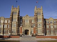
| Heritage Hall - Southern Alberta Institute of Technology | 1922 (completed) | 1987 | Calgary Calgary Calgary is a city in the Province of Alberta, Canada. It is located in the south of the province, in an area of foothills and prairie, approximately east of the front ranges of the Canadian Rockies... 51°03′43"N 114°05′29"W |
A three-storey educational building prominently situated on the brow of the Bow River valley, constructed in the Collegiate Gothic style, representative of the growth of post-secondary educational Tertiary education Tertiary education, also referred to as third stage, third level, and post-secondary education, is the educational level following the completion of a school providing a secondary education, such as a high school, secondary school, university-preparatory school... institutions in Canada in the early twentieth century |
 |
| Howse Pass Howse Pass Howse Pass is a pass through the Rocky Mountains. The pass was used by First Nations people such as the Kootenay and Piegan. European explorers first discovered the pass in 1806, and David Thompson explored it in 1807... |
1807 (explored by Europeans) | 1978 | Banff National Park Banff National Park Banff National Park is Canada's oldest national park, established in 1885 in the Rocky Mountains. The park, located 110–180 kilometres west of Calgary in the province of Alberta, encompasses of mountainous terrain, with numerous glaciers and ice fields, dense coniferous forest, and alpine... and Blaeberry River Blaeberry River The Blaeberry River is a tributary of the Columbia River in the Columbia Country of British Columbia, Canada, rising in the Canadian Rockies on the south side of Howse Pass and joining the Columbia midway between the town of Golden, at the confluence of the Kicking Horse River, and the east foot of... , BC British Columbia British Columbia is the westernmost of Canada's provinces and is known for its natural beauty, as reflected in its Latin motto, Splendor sine occasu . Its name was chosen by Queen Victoria in 1858... 51.814869°N 116.772308°W |
An early nineteenth-century trans-mountain transportation route across the Canadian Rockies Canadian Rockies The Canadian Rockies comprise the Canadian segment of the North American Rocky Mountains range. They are the eastern part of the Canadian Cordillera, extending from the Interior Plains of Alberta to the Rocky Mountain Trench of British Columbia. The southern end borders Idaho and Montana of the USA... |
|
| Jasper House Jasper House Jasper House National Historic Site, in Jasper National Park, Alberta, is the site of a trading post on the Athabasca River that functioned in two different locations from 1813 to 1884 as a major staging and supply post for travel through the Canadian Rockies.The post was originally named Rocky... |
1830 (completed) | 1924 | Jasper National Park Jasper National Park Jasper National Park is the largest national park in the Canadian Rockies, spanning 10,878 km² . It is located in the province of Alberta, north of Banff National Park and west of the City of Edmonton. The park includes the glaciers of the Columbia Icefield, hot springs, lakes, waterfalls and... 53.146807°N 117.984195°W |
Archaeological Archaeology Archaeology, or archeology , is the study of human society, primarily through the recovery and analysis of the material culture and environmental data that they have left behind, which includes artifacts, architecture, biofacts and cultural landscapes... remains of a fur trade Fur trade The fur trade is a worldwide industry dealing in the acquisition and sale of animal fur. Since the establishment of world market for in the early modern period furs of boreal, polar and cold temperate mammalian animals have been the most valued... post that served as a major destination for travellers using the Athabasca and the Yellowhead passes and the First Nations First Nations First Nations is a term that collectively refers to various Aboriginal peoples in Canada who are neither Inuit nor Métis. There are currently over 630 recognised First Nations governments or bands spread across Canada, roughly half of which are in the provinces of Ontario and British Columbia. The... route through the Smoky River Pass. |
|
| Jasper Park Information Centre Jasper Park Information Centre The Jasper Park Information Centre National Historic Site, located in Jasper National Park, Alberta, Canada, is the primary visitor contact centre for visitors to the park. Sited in the Jasper townsite, it was built as the park administration building in 1913-1914, and became the visitor contact... |
1914 (completed) | 1992 | Jasper National Park Jasper National Park Jasper National Park is the largest national park in the Canadian Rockies, spanning 10,878 km² . It is located in the province of Alberta, north of Banff National Park and west of the City of Edmonton. The park includes the glaciers of the Columbia Icefield, hot springs, lakes, waterfalls and... 52.877310°N 118.080835°W |
A rustic fieldstone Fieldstone Fieldstone is a building construction material. Strictly speaking, it is stone collected from the surface of fields where it occurs naturally... park building, symbolic of early architecture within Canada's national parks |
|
| Lac Ste. Anne Pilgrimage Lac Ste. Anne (Alberta) Lac Ste. Anne is a large lake in central Alberta, Canada. It is located in Lac Ste. Anne County, along Highway 43, 75 km west of Edmonton.... |
1889 (established) | 1984 | Lac Ste. Anne County Lac Ste. Anne County, Alberta Lac Ste. Anne County is a municipal district in central Alberta, Canada.It is located in Census Division 13, north west of Edmonton. Highway 43 stretches across this county. The municipal seat is located in the Hamlet of Sangudo.... 53°42′40"N 114°23′49"W |
First Roman Catholic mission to be established by the renowned priest, Albert Lacombe Albert Lacombe Albert Lacombe , commonly known in Alberta simply as Father Lacombe, was a French-Canadian Roman Catholic missionary who lived among and evangelized the Cree and Blackfoot First Nations of western Canada... |
|
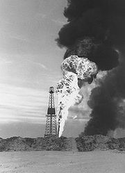
| Leduc-Woodbend Oilfield | 1946 (established) | 1990 | Leduc Leduc, Alberta - Demographics :The population of the City of Leduc according to its 2011 municipal census is 24,139, a 3.6% increase over its 2010 municipal census population of 23,293.... 53.32957°N 113.72528°W |
Site of a major crude oil discovery in Alberta, which led to the post-World War II World War II World War II, or the Second World War , was a global conflict lasting from 1939 to 1945, involving most of the world's nations—including all of the great powers—eventually forming two opposing military alliances: the Allies and the Axis... boom in petroleum Petroleum Petroleum or crude oil is a naturally occurring, flammable liquid consisting of a complex mixture of hydrocarbons of various molecular weights and other liquid organic compounds, that are found in geologic formations beneath the Earth's surface. Petroleum is recovered mostly through oil drilling... exploration and development in Western Canada Western Canada Western Canada, also referred to as the Western provinces and commonly as the West, is a region of Canada that includes the four provinces west of the province of Ontario.- Provinces :... |
 |
| Medalta Potteries | 1912 (established) | 1985 | Medicine Hat | Early twentieth century beehive kilns and manufacturing buildings; the first western Canadian manufacturer to ship goods east of the Great Lakes Great Lakes The Great Lakes are a collection of freshwater lakes located in northeastern North America, on the Canada – United States border. Consisting of Lakes Superior, Michigan, Huron, Erie, and Ontario, they form the largest group of freshwater lakes on Earth by total surface, coming in second by volume... |
|
| Medicine Hat Clay Industries | 1999 | Medicine Hat | A cultural landscape Cultural landscape Cultural Landscapes have been defined by the World Heritage Committee as distinct geographical areas or properties uniquely "..represent[ing] the combined work of nature and of man..".... illustrating the factors (local clay beds, access to railway transportation, vast supplies of natural gas to fire the kilns) that led to Medicine Hat’s emergence as the largest supplier of clay products west of Ontario |
||
| Mewata Drill Hall / Calgary Drill Hall | 1918 (completed) | 1989 | Calgary Calgary Calgary is a city in the Province of Alberta, Canada. It is located in the south of the province, in an area of foothills and prairie, approximately east of the front ranges of the Canadian Rockies... 51°02′45"N 114°05′20"W |
A large-scale drill hall Armory (military) An armory or armoury is a place where arms and ammunition are made, maintained and repaired, stored, issued to authorized users, or any combination of those... , the scale and prominent location of which exemplify the national pride that greeted Canada's strong performance in the South African War Second Boer War The Second Boer War was fought from 11 October 1899 until 31 May 1902 between the British Empire and the Afrikaans-speaking Dutch settlers of two independent Boer republics, the South African Republic and the Orange Free State... and the First World War World War I World War I , which was predominantly called the World War or the Great War from its occurrence until 1939, and the First World War or World War I thereafter, was a major war centred in Europe that began on 28 July 1914 and lasted until 11 November 1918... |
|
| Nordegg Nordegg, Alberta Nordegg is a hamlet in west-central Alberta, Canada within Clearwater County. It is located in the North Saskatchewan River valley in the foothills of the Canadian Rockies, at the crossroads of David Thompson Highway and the Highway 734 spur of the Bighorn Highway.- History :The community was... |
1911 (mine established) | 2001 | Nordegg Nordegg, Alberta Nordegg is a hamlet in west-central Alberta, Canada within Clearwater County. It is located in the North Saskatchewan River valley in the foothills of the Canadian Rockies, at the crossroads of David Thompson Highway and the Highway 734 spur of the Bighorn Highway.- History :The community was... 52°28′30"N 116°4′24"W |
An important coal mining landscape, with many mining and related resources still existing on site | |
| Notre Dame des Victoires / Lac La Biche Mission | 1853 (established) | 1989 | Lac La Biche | An important Roman Catholic mission, established by the Oblates of Mary Immaculate, which served as the hub of various portage routes | |
| Old Women's Buffalo Jump | 1960 | Cayley Cayley, Alberta Cayley is a hamlet in southern Alberta, Canada within the Municipal District of Foothills No. 31. It is also recognized as a designated place by Statistics Canada.... |
An aboriginal bison drive in use for more than 1500 years | ||
| Palace Theatre | 1921 (completed) | 1996 | Calgary Calgary Calgary is a city in the Province of Alberta, Canada. It is located in the south of the province, in an area of foothills and prairie, approximately east of the front ranges of the Canadian Rockies... |
A movie palace Movie palace A movie palace is a term used to refer to the large, elaborately decorated movie theaters built between the 1910s and the 1940s. The late 1920s saw the peak of the movie palace, with hundreds opened every year between 1925 and 1930.There are three building types in particular which can be subsumed... designed by internationally renowned theatre architect C. Howard Crane C. Howard Crane Charles Howard Crane was an American architect.Born in Hartford, Connecticut, Crane established a practice in Detroit, Michigan early in the 20th Century. Like Thomas W. Lamb and John Eberson, Crane specialized in the design of movie palaces in North American... , and one of four surviving movie theatres in Canada built by the Allen Chain |
|
| Prince of Wales Hotel Prince of Wales Hotel The Prince of Wales Hotel is located in Waterton Lakes National Park in Alberta, Canada, overlooking Upper Waterton Lake, near the Canada-United States border. Constructed between 1926 and 1927, the hotel was built by the American Great Northern Railway to lure American tourists during the... |
1927 (completed) | 1992 | Waterton Lakes National Park Waterton Lakes National Park Waterton Lakes National Park is a national park located in the southwest corner of Alberta, Canada, and borders Glacier National Park in Montana, USA. Waterton was Canada's fourth national park, formed in 1895 and named after Waterton Lake, in turn after the Victorian naturalist and conservationist... 49°03′32"N 113°54′13"W |
A landmark hotel constructed in the rustic-design style, representing the golden age of railway resort development in Canada's national parks | |
| Rocky Mountain House | 1799 (established) | 1926 | Rocky Mountain House, Alberta Rocky Mountain House, Alberta Rocky Mountain House is a town in west-central Alberta, Canada, approximately west of the City of Red Deer. It is located at the confluence of the Clearwater and North Saskatchewan Rivers, and at the crossroads of Highway 22 and Highway 11 .- History :The town has a long history dating to the... |
An archaeological site that contains the remains of several early 19th-century fur trade forts known by the names of Rocky Mountain House (established by the North West Company North West Company The North West Company was a fur trading business headquartered in Montreal from 1779 to 1821. It competed with increasing success against the Hudson's Bay Company in what was to become Western Canada... ) and Acton House (established by the Hudson's Bay Company Hudson's Bay Company The Hudson's Bay Company , abbreviated HBC, or "The Bay" is the oldest commercial corporation in North America and one of the oldest in the world. A fur trading business for much of its existence, today Hudson's Bay Company owns and operates retail stores throughout Canada... ) |
|
| Rundle's Mission Rundle's Mission Rundle's Mission was established in 1847 on the shores of Pigeon Lake near Thorsby, Alberta by a Methodist missionary named Robert Rundle. From the mission Rundle taught Cree people about Christianity and agriculture, refusing to acquiesce to pressures from the Hudson's Bay Company or the... |
1847 (established) | 1963 | Pigeon Lake Pigeon Lake (Alberta) Pigeon Lake is a large lake in central Alberta, Canada. It is a popular recreation lake, with some shores having sandy beaches and others having steeper banks that are less suitable to "beach activities". Pigeon Lake is located close to large communities such as Edmonton, Leduc and Wetaskiwin... 53.025°N 114.067°W |
The site of the first Protestant mission Mission (station) A religious mission or mission station is a location for missionary work.While primarily a Christian term, the concept of the religious "mission" is also used prominently by the Church of Scientology and their Scientology Missions International.... in the Canadian Prairies Canadian Prairies The Canadian Prairies is a region of Canada, specifically in western Canada, which may correspond to several different definitions, natural or political. Notably, the Prairie provinces or simply the Prairies comprise the provinces of Alberta, Saskatchewan, and Manitoba, as they are largely covered... |
|
| Skoki Ski Lodge Skoki Ski Lodge The Skoki Ski Lodge National Historic Site of Canada was built in 1930-31 in the Skoki Valley of Canada's Banff National Park. Built by local members of the Ski Club of the Canadian Rockies, the lodge was the first commercial building built specifically to serve skiers in Canada, and possibly in... |
1936 (completed) | 1992 | Banff National Park Banff National Park Banff National Park is Canada's oldest national park, established in 1885 in the Rocky Mountains. The park, located 110–180 kilometres west of Calgary in the province of Alberta, encompasses of mountainous terrain, with numerous glaciers and ice fields, dense coniferous forest, and alpine... |
A rustic ski lodge resort, representing the early visual identity of Canada's mountain parks and of the early days of tourism in Banff National Park | |
| St. Patrick's Roman Catholic Church | 1914 (completed) | 1990 | Medicine Hat | A noted example of Gothic Revival architecture Gothic Revival architecture The Gothic Revival is an architectural movement that began in the 1740s in England... in Alberta |
|
| Stephen Avenue Stephen Avenue Stephen Avenue is a major pedestrian mall in downtown Calgary, Alberta, Canada. The mall is actually the portion of 8 Avenue SW between 4 Street SW and 1 Street SE. It is open to vehicles only from 6:00 p.m. to 6:00 a.m.... |
1880 (established) | 2002 | Calgary Calgary Calgary is a city in the Province of Alberta, Canada. It is located in the south of the province, in an area of foothills and prairie, approximately east of the front ranges of the Canadian Rockies... 51.0456°N 114.0630°W |
A late-nineteenth-century retail streetscape in downtown Calgary | 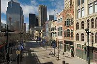 |
| Stirling Agricultural Village Stirling Agricultural Village Stirling Agricultural Village is a National Historic Site of Canada, and was listed as one of only three communities in Canada designated as a National Historic Site because of the community’s well preserved settlement pattern that follows the Plat of Zion model... |
1899 (established) | 1997 | Stirling Stirling, Alberta Stirling is a village in the County of Warner No. 5, Alberta, Canada. The village is located on Highway 4, approximately southeast of Lethbridge and northwest of the United States-Canada border.... |
The best surviving example of a Mormon Mormon The term Mormon most commonly denotes an adherent, practitioner, follower, or constituent of Mormonism, which is the largest branch of the Latter Day Saint movement in restorationist Christianity... agricultural village in Canada, following the Plat of Zion Zion (Latter Day Saints) Within the Latter Day Saint movement, Zion is often used to connote a utopian association of the righteous. This association would practice a form of communitarian economics called the United Order meant to ensure that all members maintained an acceptable quality of life, class distinctions were... model |
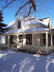 |
| Suffield Tipi Rings | 1973 | Cypress County Cypress County, Alberta Cypress County is a municipal district located in southeastern Alberta, Canada. The County completely surrounds the City of Medicine Hat and the Town of Redcliff.The municipality is part of Census Division 1, Alberta.- Geography :... |
Various sets of archaeological remains relating to the cultural occupations by the Niitsitapi, featuring tipi rings, medicine wheel Medicine wheel Medicine wheels, or sacred hoops, were constructed by laying stones in a particular pattern on the ground. Most medicine wheels follow the basic pattern of having a center of stone, and surrounding that is an outer ring of stones with "spokes", or lines of rocks radiating from the center... s and other rock arrangements |
||
| Sulphur Mountain Cosmic Ray Station Sulphur Mountain Cosmic Ray Station Sulphur Mountain Cosmic Ray Station, a National Historic Site of Canada found atop Sulphur Mountain in Banff National Park, commemorates Canada's participation in the International Geophysical Year, during 1957 to 1958. Canada constructed nine sites to study cosmic rays, but this site in particular... |
1957 (completed) | 1982 | Banff National Park Banff National Park Banff National Park is Canada's oldest national park, established in 1885 in the Rocky Mountains. The park, located 110–180 kilometres west of Calgary in the province of Alberta, encompasses of mountainous terrain, with numerous glaciers and ice fields, dense coniferous forest, and alpine... |
Canada’s most important cosmic ray Cosmic ray Cosmic rays are energetic charged subatomic particles, originating from outer space. They may produce secondary particles that penetrate the Earth's atmosphere and surface. The term ray is historical as cosmic rays were thought to be electromagnetic radiation... observatory from the 1950s |
|
| Temple of the Church of Jesus Christ of Latter Day Saints Cardston Alberta Temple The Cardston Alberta Temple is the eighth constructed and sixth operating temple of The Church of Jesus Christ of Latter-day Saints. Located in Cardston, Alberta, it is the oldest LDS temple outside the United States. It is one of eight temples that do not have an angel Moroni statue, and one of... |
1923 (completed) | 1992 | Cardston Cardston, Alberta -Demographics:The population of the Town of Cardston according to its 2007 municipal census is 3,578.In 2006, it had a population of 3,452 living in 1,234 dwellings, a 0.7% decrease from 2001... |
A monumental modern temple in historic Mormon Mormon The term Mormon most commonly denotes an adherent, practitioner, follower, or constituent of Mormonism, which is the largest branch of the Latter Day Saint movement in restorationist Christianity... centre |
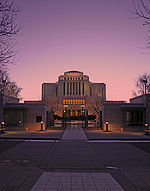 |
| Territorial Court House | 1904 (completed) | 1980 | Fort MacLeod Fort Macleod, Alberta Fort Macleod is a town in the southwest corner of the province of Alberta, Canada. It was founded as a North-West Mounted Police barracks, and is named in honour of the North-West Mounted Police Colonel James Macleod. The town's current mayor is Shawn Patience.- History and heritage preservation... |
The oldest court house in Alberta and one of the few buildings surviving from the period of Territorial administration of the Canadian Prairies Canadian Prairies The Canadian Prairies is a region of Canada, specifically in western Canada, which may correspond to several different definitions, natural or political. Notably, the Prairie provinces or simply the Prairies comprise the provinces of Alberta, Saskatchewan, and Manitoba, as they are largely covered... |
|
| Treaty Nº 7 Signing Site | 1877 (treaty signed) | 1925 | Wheatland County Wheatland County, Alberta Wheatland County is a municipal district in south-central Alberta, Canada, east of Calgary.It is located in Census Division 5. The municipal seat is the Town of Strathmore.-Demographics:... |
The site where representatives of the Siksika Siksika Nation The Siksika Nation is a First Nation in southern Alberta, Canada. The name Siksiká comes from the Blackfoot words sik and iká , with a connector s between the two words. The plural form of Siksiká is Siksikáwa... , Pekuni, Kainai Kainai Nation The Kainai Nation is a First Nation in southern Alberta, Canada with a population of 7,437 members in 2005, and had a population of 9,035 members as of 9 February 2008... , Nakoda Nakoda (people) The Nakoda are a First Nation group, indigenous to both Canada and, originally, the United States.... and Tsuu T’ina Tsuu T'ina Nation The Tsuu T'ina Nation is a First Nation in Canada. Their territory is located on the Indian reserve Tsuu T'ina Nation 145, whose east side is adjacent to the southwest city limits of Calgary, Alberta... peoples met with representatives of the Crown The Crown The Crown is a corporation sole that in the Commonwealth realms and any provincial or state sub-divisions thereof represents the legal embodiment of governance, whether executive, legislative, or judicial... to sign Treaty No. 7 Treaty 7 Treaty 7 was an agreement between Queen Victoria and several mainly Blackfoot First Nations tribes in what is today the southern portion of Alberta. It was concluded on September 22, 1877. The agreement was signed at the Blackfoot Crossing of the Bow River, at the present-day Siksika Nation... in September 1877 |
|
| Turner Valley Gas Plant | 1914 (established) | 1995 | Turner Valley Turner Valley, Alberta Turner Valley is a town in Alberta, Canada. It is located southwest of Calgary.Situated on Highway 22 , the town was once the centre of an oil and natural gas boom. For 30 years, the Turner Valley Oilfields was a major supplier of oil and gas and the largest producer in the British Empire, but is... |
A petroleum industrial complex comprising 22 metal buildings and related infrastructure, and the site of two early gas wells that established the Turner Valley as the most important oil field in Alberta | |
| Turner Valley Oilfield | 1914 (established) | 1990 | Turner Valley Turner Valley, Alberta Turner Valley is a town in Alberta, Canada. It is located southwest of Calgary.Situated on Highway 22 , the town was once the centre of an oil and natural gas boom. For 30 years, the Turner Valley Oilfields was a major supplier of oil and gas and the largest producer in the British Empire, but is... |
The first major oil field in Alberta | |
| Victoria Settlement | 1863 (established) | 2001 | Smoky Lake Smoky Lake, Alberta Smoky Lake is a town in central Alberta, Canada. It is located northeast of Edmonton at the junction of Highway 28 and Highway 855. It lies between the North Saskatchewan River, Smoky Creek and White Earth Creek. Long Lake Provincial Park is located north of the town.- Demographics :In 2006,... |
A cultural landscape Cultural landscape Cultural Landscapes have been defined by the World Heritage Committee as distinct geographical areas or properties uniquely "..represent[ing] the combined work of nature and of man..".... illustrating major themes in the development of the Canadian Prairies Canadian Prairies The Canadian Prairies is a region of Canada, specifically in western Canada, which may correspond to several different definitions, natural or political. Notably, the Prairie provinces or simply the Prairies comprise the provinces of Alberta, Saskatchewan, and Manitoba, as they are largely covered... , including the rise of the fur trade, the establishment of the Métis river lot system, the arrival of missions, prairie agricultural development and the arrival of eastern European immigrants |
|
| Wetaskiwin Court House | 1909 (completed) | 1980 | Wetaskiwin Wetaskiwin, Alberta Wetaskiwin is a small city in the province of Alberta, Canada. The city is located south of the provincial capital of Edmonton. The city name comes from the Cree word wītaskīwin-ispatinaw , meaning "the hills where peace was made".... |
A court house symbolic of the rapid growth of the justice system in Alberta, typifying court house design during this formative period in the growth of western Canada Western Canada Western Canada, also referred to as the Western provinces and commonly as the West, is a region of Canada that includes the four provinces west of the province of Ontario.- Provinces :... |
|
| Yellowhead Pass Yellowhead Pass The Yellowhead Pass is a mountain pass across the Continental Divide of the Canadian Rockies. It is located on the border between the Canadian provinces of Alberta and British Columbia, and lies within Jasper National Park and Mount Robson Provincial Park.... |
1971 | Jasper National Park Jasper National Park Jasper National Park is the largest national park in the Canadian Rockies, spanning 10,878 km² . It is located in the province of Alberta, north of Banff National Park and west of the City of Edmonton. The park includes the glaciers of the Columbia Icefield, hot springs, lakes, waterfalls and... 52°53′33"N 118°27′50"W |
An important transportation route through the Canadian Rockies Canadian Rockies The Canadian Rockies comprise the Canadian segment of the North American Rocky Mountains range. They are the eastern part of the Canadian Cordillera, extending from the Interior Plains of Alberta to the Rocky Mountain Trench of British Columbia. The southern end borders Idaho and Montana of the USA... |
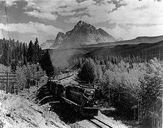 |
See also
- History of AlbertaHistory of AlbertaWhat is today the province of Alberta, Canada has a history and prehistory stretching back thousands of years. Recorded or written history begins with the arrival of Europeans.-Native groups:...
- List of provincial historic sites of Alberta

