
Abbot Pass hut
Encyclopedia
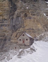
The Abbot Pass hut is an alpine hut located at an altitude of 2925 metres (9,598 feet) in Abbot Pass
in the Rocky Mountains
in Alberta
, Canada
. It is nestled between Mount Victoria
and Mount Lefroy
, straddling the continental divide
, which, in this region, defines the boundary between Banff National Park
in Alberta and Yoho National Park
in British Columbia
. While close to the border, the hut lies entirely in Banff National Park, and is the second-highest permanently habitable structure in Canada (after the Neil Colgan hut
). The hut is maintained by the Alpine Club of Canada
.
to shelter clients attempting to climb Victoria and Lefroy. Much of the construction material was carried from Lake Louise
on horseback across the Victoria Glacier and winched or carried on guides' backs up the pass on a route known as The Deathtrap because of its exposure to avalanches and crevasses.
The CPR operated the hut for 40 years, and in the 1960s turned the operation over to Parks Canada
, which renovated it with the help of volunteers. In 1985, the park service turned the hut over to the Alpine Club of Canada
, which has renovated it several times since. The hut was designated Abbot Pass Refuge Cabin National Historic Site of Canada in 1992, and, in 1997, a federal plaque was placed outside its front door.
area on the British Columbia
side (hiking past Lake Oesa), or the more technically demanding route from Lake Louise
on the Alberta
side. The hut is rarely used in winter due to avalanche hazard.
is by far the most popular route into the hut. It is safer and less technical
than going in via the Deathtrap or the Fuhrmann Ledges. It involves about 900 metres (3,000 feet) of elevation gain and 3 to 5+ hours from Lake O'Hara to the hut depending on conditions and the strength of the party. People should not automatically assume they can always get to the hut, since some groups have been caught out overnight on the trail or stranded at the hut in bad weather conditions.
The first hurdle on this approach is getting on the bus to Lake O'Hara. The bus is operated by Parks Canada
and is used to control the number of people going to Lake O'Hara. Reservations are difficult to obtain; however an automatic reservation on the bus can be obtained by booking a reservation at the Abbot Pass hut with the Alpine Club of Canada
. Persons doing so should carry proof of their reservation because they will not be able to get on the bus without it. The alternative is to walk 10 km up the access road carrying all their equipment.
From Lake O'Hara, people going to the hut can follow the signed hiking
trails to Lake Oesa to a sign marking the end of the Parks Canada trail, at which point it becomes largely scrambling
. A trail has been built to the hut by the Alpine Club, but parts of it are sometimes erased by rockslide
s, so route finding skills are helpful. It is steep and covered with scree
. A helmet
is a good safety precaution in case of rockfall
, and an ice axe
in case of ice or snow on the trail. One avalanche
fatality has occurred on the route, so it should not be undertaken when avalanches are possible.
involves significant objective hazards. A broad path leads from the Chateau Lake Louise
along the lake shore past the teahouse and on to the Plain of Six Glaciers. It then continues on into the deep gorge between Mount Victoria
and Mount Lefroy
- known as The Deathtrap. Persons going through this should move rapidly in case of serac
fall or avalanche
s from the glaciers above. It involves crossing a number of crevasse
s in the glacier and may be impassible due to wall-to-wall bergschrund
at the upper end. This is not an attractive route and should only be attempted by strong alpinists when there is deep snow cover on the glacier.
and Mount Lefroy
(both over 3400 metres / 11,000 feet), and as a destination in itself for ambitious hikers. One of the reasons for the popularity of the hut is that climbers can ascend both Victoria and Lefroy in a weekend.
The normal route up Mount Lefroy (3423 m / 11,230 ft) is via the west face, going straight up the slopes from the hut toward the summit. There are routes up three separate gullies from the hut. The choice of the best one depends on snow conditions.
The most popular route up Mount Victoria (3464 m / 11,365 ft) is from the hut via the southeast ridge to the south summit. Another popular route is a traverse of Mount Victoria, which can be done in either direction, either to or from the hut.
In a rarely-observed feat of ursine mountaineering, a grizzly bear
was once seen doing the traverse of Mount Victoria via Abbot Pass. They are only occasional visitors to the hut, however.
This map shows trails and area highlights in detail This map shows trails and area highlights in detail
Abbot Pass
Abbot Pass lies between Mount Lefroy and Mount Victoria, in the divide between the valleys of Lake O'Hara and Lake Louise. It was named for Phillip Stanley Abbot who died in 1896 in an attempt to climb Mount Lefroy with Charles Fay, Charles Thompson, and George T...
in the Rocky Mountains
Alberta's Rockies
Alberta's Rockies comprises the Canadian Rockies in the province of Alberta, Canada. It is a region on the southwestern part of the province, along the British Columbia border. It covers all but the south of Census Division 15....
in Alberta
Alberta
Alberta is a province of Canada. It had an estimated population of 3.7 million in 2010 making it the most populous of Canada's three prairie provinces...
, Canada
Canada
Canada is a North American country consisting of ten provinces and three territories. Located in the northern part of the continent, it extends from the Atlantic Ocean in the east to the Pacific Ocean in the west, and northward into the Arctic Ocean...
. It is nestled between Mount Victoria
Mount Victoria (Alberta/British Columbia)
Mount Victoria is a mountain on the Continental Divide, at the border of Alberta and British Columbia in western Canada. The mountain is located on the western buttress of Abbot Pass.The mountain was named by J. Norman Collie in 1897 for Queen Victoria....
and Mount Lefroy
Mount Lefroy
Mount Lefroy is a mountain on the Continental Divide, at the border of Alberta and British Columbia in western Canada. The mountain is located on the eastern side of Abbot Pass.The mountain was named by George M...
, straddling the continental divide
Continental divide
A continental divide is a drainage divide on a continent such that the drainage basin on one side of the divide feeds into one ocean or sea, and the basin on the other side either feeds into a different ocean or sea, or else is endorheic, not connected to the open sea...
, which, in this region, defines the boundary between Banff National Park
Banff National Park
Banff National Park is Canada's oldest national park, established in 1885 in the Rocky Mountains. The park, located 110–180 kilometres west of Calgary in the province of Alberta, encompasses of mountainous terrain, with numerous glaciers and ice fields, dense coniferous forest, and alpine...
in Alberta and Yoho National Park
Yoho National Park
Yoho National Park is located in the Canadian Rocky Mountains along the western slope of the Continental Divide in southeastern British Columbia. Yoho NP is bordered by Kootenay National Park on the southern side and Banff National Park on the eastern side...
in British Columbia
British Columbia
British Columbia is the westernmost of Canada's provinces and is known for its natural beauty, as reflected in its Latin motto, Splendor sine occasu . Its name was chosen by Queen Victoria in 1858...
. While close to the border, the hut lies entirely in Banff National Park, and is the second-highest permanently habitable structure in Canada (after the Neil Colgan hut
Neil Colgan Hut
The Neil Colgan Hut is an alpine hut located on the Fay Glacier in Kootenay National Park. It is situated in a col between Mount Little and Mount Bowlen, which is one of the peaks overlooking The Valley of the Ten Peaks. The hut is maintained by the Alpine Club of Canada...
). The hut is maintained by the Alpine Club of Canada
Alpine Club of Canada
The Alpine Club of Canada is a mountain club with a National Office in Canmore, Alberta that has been a focal point for Canadian mountaineering since its founding in 1906. The club was co-founded by Arthur Oliver Wheeler, who served as its first president, and Elizabeth Parker, a journalist for...
.
History
The pass and the hut are named after Philip Stanley Abbot, who became the first mountaineering fatality in North America after he fell in an attempt to make the first ascent of Mount Lefroy in 1896. The hut was originally built in 1922 by Swiss guides working for the Canadian Pacific RailwayCanadian Pacific Railway
The Canadian Pacific Railway , formerly also known as CP Rail between 1968 and 1996, is a historic Canadian Class I railway founded in 1881 and now operated by Canadian Pacific Railway Limited, which began operations as legal owner in a corporate restructuring in 2001...
to shelter clients attempting to climb Victoria and Lefroy. Much of the construction material was carried from Lake Louise
Lake Louise (Alberta)
Lake Louise is a lake in Alberta, Canada. The glacial lake is located in Banff National Park, from the hamlet of Lake Louise and the Trans-Canada Highway....
on horseback across the Victoria Glacier and winched or carried on guides' backs up the pass on a route known as The Deathtrap because of its exposure to avalanches and crevasses.
The CPR operated the hut for 40 years, and in the 1960s turned the operation over to Parks Canada
Parks Canada
Parks Canada , also known as the Parks Canada Agency , is an agency of the Government of Canada mandated to protect and present nationally significant natural and cultural heritage, and foster public understanding, appreciation, and enjoyment in ways that ensure their ecological and commemorative...
, which renovated it with the help of volunteers. In 1985, the park service turned the hut over to the Alpine Club of Canada
Alpine Club of Canada
The Alpine Club of Canada is a mountain club with a National Office in Canmore, Alberta that has been a focal point for Canadian mountaineering since its founding in 1906. The club was co-founded by Arthur Oliver Wheeler, who served as its first president, and Elizabeth Parker, a journalist for...
, which has renovated it several times since. The hut was designated Abbot Pass Refuge Cabin National Historic Site of Canada in 1992, and, in 1997, a federal plaque was placed outside its front door.
Access
Abbot Pass (and the hut) may be approached from either the Lake O'HaraLake o'hara
Lake O'Hara a lake at an elevation of 2,115 m in the alpine area of Yoho National Park, in the province of British Columbia, on the western side of the Great Divide with the province of Alberta and Banff National Park to the east...
area on the British Columbia
British Columbia
British Columbia is the westernmost of Canada's provinces and is known for its natural beauty, as reflected in its Latin motto, Splendor sine occasu . Its name was chosen by Queen Victoria in 1858...
side (hiking past Lake Oesa), or the more technically demanding route from Lake Louise
Lake Louise (Alberta)
Lake Louise is a lake in Alberta, Canada. The glacial lake is located in Banff National Park, from the hamlet of Lake Louise and the Trans-Canada Highway....
on the Alberta
Alberta
Alberta is a province of Canada. It had an estimated population of 3.7 million in 2010 making it the most populous of Canada's three prairie provinces...
side. The hut is rarely used in winter due to avalanche hazard.
From Lake O'Hara
The approach via Lake O'HaraLake o'hara
Lake O'Hara a lake at an elevation of 2,115 m in the alpine area of Yoho National Park, in the province of British Columbia, on the western side of the Great Divide with the province of Alberta and Banff National Park to the east...
is by far the most popular route into the hut. It is safer and less technical
Grade (climbing)
In rock climbing, mountaineering and other climbing disciplines, climbers give a climbing grade to a route that concisely describes the difficulty and danger of climbing the route...
than going in via the Deathtrap or the Fuhrmann Ledges. It involves about 900 metres (3,000 feet) of elevation gain and 3 to 5+ hours from Lake O'Hara to the hut depending on conditions and the strength of the party. People should not automatically assume they can always get to the hut, since some groups have been caught out overnight on the trail or stranded at the hut in bad weather conditions.
The first hurdle on this approach is getting on the bus to Lake O'Hara. The bus is operated by Parks Canada
Parks Canada
Parks Canada , also known as the Parks Canada Agency , is an agency of the Government of Canada mandated to protect and present nationally significant natural and cultural heritage, and foster public understanding, appreciation, and enjoyment in ways that ensure their ecological and commemorative...
and is used to control the number of people going to Lake O'Hara. Reservations are difficult to obtain; however an automatic reservation on the bus can be obtained by booking a reservation at the Abbot Pass hut with the Alpine Club of Canada
Alpine Club of Canada
The Alpine Club of Canada is a mountain club with a National Office in Canmore, Alberta that has been a focal point for Canadian mountaineering since its founding in 1906. The club was co-founded by Arthur Oliver Wheeler, who served as its first president, and Elizabeth Parker, a journalist for...
. Persons doing so should carry proof of their reservation because they will not be able to get on the bus without it. The alternative is to walk 10 km up the access road carrying all their equipment.
From Lake O'Hara, people going to the hut can follow the signed hiking
Hiking
Hiking is an outdoor activity which consists of walking in natural environments, often in mountainous or other scenic terrain. People often hike on hiking trails. It is such a popular activity that there are numerous hiking organizations worldwide. The health benefits of different types of hiking...
trails to Lake Oesa to a sign marking the end of the Parks Canada trail, at which point it becomes largely scrambling
Scrambling
Scrambling is a method of ascending rocky faces and ridges. It is an ambiguous term that lies somewhere between hillwalking and rock climbing. It is often distinguished from hillwalking by defining a scramble as a route where hands must be used in the ascent...
. A trail has been built to the hut by the Alpine Club, but parts of it are sometimes erased by rockslide
Landslide
A landslide or landslip is a geological phenomenon which includes a wide range of ground movement, such as rockfalls, deep failure of slopes and shallow debris flows, which can occur in offshore, coastal and onshore environments...
s, so route finding skills are helpful. It is steep and covered with scree
Scree
Scree, also called talus, is a term given to an accumulation of broken rock fragments at the base of crags, mountain cliffs, or valley shoulders. Landforms associated with these materials are sometimes called scree slopes or talus piles...
. A helmet
Helmet
A helmet is a form of protective gear worn on the head to protect it from injuries.Ceremonial or symbolic helmets without protective function are sometimes used. The oldest known use of helmets was by Assyrian soldiers in 900BC, who wore thick leather or bronze helmets to protect the head from...
is a good safety precaution in case of rockfall
Rockfall
Rockfall or rock-fall refers to quantities of rock falling freely from a cliff face. A rockfall is a fragment of rock detached by sliding, toppling, or falling, that falls along a vertical or sub-vertical cliff, proceeds down slope by bouncing and flying along ballistic trajectories or by rolling...
, and an ice axe
Ice axe
An ice axe, is a multi-purpose ice and snow tool used by mountaineers both in the ascent and descent of routes which involve frozen conditions. It can be held and employed in a number of different ways, depending on the terrain encountered...
in case of ice or snow on the trail. One avalanche
Avalanche
An avalanche is a sudden rapid flow of snow down a slope, occurring when either natural triggers or human activity causes a critical escalating transition from the slow equilibrium evolution of the snow pack. Typically occurring in mountainous terrain, an avalanche can mix air and water with the...
fatality has occurred on the route, so it should not be undertaken when avalanches are possible.
From Lake Louise
The route from Lake LouiseLake Louise (Alberta)
Lake Louise is a lake in Alberta, Canada. The glacial lake is located in Banff National Park, from the hamlet of Lake Louise and the Trans-Canada Highway....
involves significant objective hazards. A broad path leads from the Chateau Lake Louise
Chateau Lake Louise
The Fairmont Chateau Lake Louise is a Fairmont Hotel on the eastern shore of Lake Louise, near Banff, Alberta. The original Chateau was gradually built up at the end of the 19th and the beginning of the 20th century by the Canadian Pacific Railway and was thus "kin" to its predecessors, the Banff...
along the lake shore past the teahouse and on to the Plain of Six Glaciers. It then continues on into the deep gorge between Mount Victoria
Mount Victoria (Canada)
Mount Victoria, , is a mountain on the border between British Columbia and Alberta in the Canadian Rockies. It is located just northeast of Lake O'Hara in Yoho National Park and is also part of Banff National Park and is on the Continental Divide ....
and Mount Lefroy
Mount Lefroy
Mount Lefroy is a mountain on the Continental Divide, at the border of Alberta and British Columbia in western Canada. The mountain is located on the eastern side of Abbot Pass.The mountain was named by George M...
- known as The Deathtrap. Persons going through this should move rapidly in case of serac
Serac
A serac is a block or column of ice formed by intersecting crevasses on a glacier. Often house-sized or larger, they are dangerous to mountaineers since they may topple with little warning...
fall or avalanche
Avalanche
An avalanche is a sudden rapid flow of snow down a slope, occurring when either natural triggers or human activity causes a critical escalating transition from the slow equilibrium evolution of the snow pack. Typically occurring in mountainous terrain, an avalanche can mix air and water with the...
s from the glaciers above. It involves crossing a number of crevasse
Crevasse
A crevasse is a deep crack in an ice sheet rhys glacier . Crevasses form as a result of the movement and resulting stress associated with the sheer stress generated when two semi-rigid pieces above a plastic substrate have different rates of movement...
s in the glacier and may be impassible due to wall-to-wall bergschrund
Bergschrund
A bergschrund is a crevasse that forms where the moving glacier ice separates from the stagnant ice above. It is often a serious obstacle for mountaineers, who sometimes abbreviate "bergschrund" to "schrund"....
at the upper end. This is not an attractive route and should only be attempted by strong alpinists when there is deep snow cover on the glacier.
Activities
The hut is often used as a base for alpine climbing on Mount VictoriaMount Victoria (Alberta/British Columbia)
Mount Victoria is a mountain on the Continental Divide, at the border of Alberta and British Columbia in western Canada. The mountain is located on the western buttress of Abbot Pass.The mountain was named by J. Norman Collie in 1897 for Queen Victoria....
and Mount Lefroy
Mount Lefroy
Mount Lefroy is a mountain on the Continental Divide, at the border of Alberta and British Columbia in western Canada. The mountain is located on the eastern side of Abbot Pass.The mountain was named by George M...
(both over 3400 metres / 11,000 feet), and as a destination in itself for ambitious hikers. One of the reasons for the popularity of the hut is that climbers can ascend both Victoria and Lefroy in a weekend.
The normal route up Mount Lefroy (3423 m / 11,230 ft) is via the west face, going straight up the slopes from the hut toward the summit. There are routes up three separate gullies from the hut. The choice of the best one depends on snow conditions.
The most popular route up Mount Victoria (3464 m / 11,365 ft) is from the hut via the southeast ridge to the south summit. Another popular route is a traverse of Mount Victoria, which can be done in either direction, either to or from the hut.
In a rarely-observed feat of ursine mountaineering, a grizzly bear
Grizzly Bear
The grizzly bear , also known as the silvertip bear, the grizzly, or the North American brown bear, is a subspecies of brown bear that generally lives in the uplands of western North America...
was once seen doing the traverse of Mount Victoria via Abbot Pass. They are only occasional visitors to the hut, however.
Facilities
The hut sleeps 24 on its upper floor, and has both a wood stove for heating and drying, and a propane system for cooking and lighting. The kitchen is stocked with standard cooking utensils. Wood and propane are flown in annually by helicopter, by the Alpine Club of Canada. There is an outhouse a short distance from the hut. Since human waste must be flown out by helicopter at great cost, visitors should avoid dumping garbage in the toilet.Nearby
- Mount VictoriaMount Victoria (Alberta/British Columbia)Mount Victoria is a mountain on the Continental Divide, at the border of Alberta and British Columbia in western Canada. The mountain is located on the western buttress of Abbot Pass.The mountain was named by J. Norman Collie in 1897 for Queen Victoria....
- Mount LefroyMount LefroyMount Lefroy is a mountain on the Continental Divide, at the border of Alberta and British Columbia in western Canada. The mountain is located on the eastern side of Abbot Pass.The mountain was named by George M...
- Lake LouiseLake Louise (Alberta)Lake Louise is a lake in Alberta, Canada. The glacial lake is located in Banff National Park, from the hamlet of Lake Louise and the Trans-Canada Highway....
- Lake O'HaraLake o'haraLake O'Hara a lake at an elevation of 2,115 m in the alpine area of Yoho National Park, in the province of British Columbia, on the western side of the Great Divide with the province of Alberta and Banff National Park to the east...
- Elizabeth Parker hutElizabeth Parker hutThe Elizabeth Parker hut is an alpine hut located in Yoho National Park in British Columbia at an altitude of 2040 metres in a small subalpine meadow about 500 metres west of Lake O'Hara. It is surrounded by some of the most spectacular mountain scenery in the Canadian Rockies. The hut actually...
Maps
| Map reference | 82N/8 (Lake Louise) |
| Grid reference | 495903 |
| GPS coordinates | 51°21′54″N 116°17′12″W NAD83 11U 549660 5690657 |
| Hut elevation | 2925 metres (9,598 feet). |
This map shows trails and area highlights in detail This map shows trails and area highlights in detail
External links
- Abbot Pass hut at the Alpine Club of Canada
- Abbot Pass hut at bivouac.com
- Weather forecasts from Environment Canada
- Public avalanche bulletins from the Canadian Avalanche Centre
- Yoho National Park at Parks Canada
- Google Earth Find the Abbot Pass hut at 51°21′50.598″ N, 116°17′24.7488″ W