
Peace River, Alberta
Encyclopedia
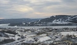
Peace River is a town in northwestern Alberta
, Canada
, situated along the banks of the Peace River
, at its confluence with the Smoky River
, the Heart River
and Pat's Creek
. It is located 486 kilometres (302 mi) northwest of Edmonton
, and 198 kilometres (123 mi) northeast of Grande Prairie, along Highway 2. The Peace River townsite is nearly 1000 feet (304.8 m) below the relatively flat terrain surrounding it. Pat's Creek used to be an open channel though the town but is now a channeled though a culvert
under the town streets, re-emerging at the mouth on the Peace River at the Riverfront Park.
The population in the Town of Peace River was registered to be 6,315 in 2006, a 1.2% increase over its 2001 population. There is significant nodal settlements and subdivisions in the vicinity of the town on acreages along Highway 2 to the west, Highways 684 (Shaftesbury Trail) and 743 as well as the southwest portion of Northern Sunrise County. Regionally, there are various First Nation communities to the northeast, French-Canadian farming communities to the south and to the east, and Mennonite and Hutterite German-Canadian farming communities to the north and northwest of the town.
Peace River was the site of the 2004 Alberta Winter Games. In 2010, Peace River, in conjunction with Grimshaw and surrounding municipalities, jointly hosted the 2010 Alberta Summer Games. These Games are held every two years and are Alberta's largest sporting event.
.
In 1670, following the arrival of the Hudson's Bay Company
in Eastern Canada
, guns began making their way westward as trade goods and the Algonquian
speaking Cree
began pushing the Athapaskan speakers Dunne-za or Beaver further west. The Beaver in turn pushed the Sekani
deep into the Rocky Mountain Trench
in the mid-18th century. A truce was eventually agreed to by the Cree and the Beaver and the great river they called Unchagah (the Peace River) became the boundary between their hunting territories.
The North West Company
pushed westward in the late 18th century in an attempts to reach the Pacific Ocean
, creating rivalry with the other major fur-trading company, the Hudson's Bay Company.
The NAR Station was used again as a railway station for first time in about 30 years by passengers when the Alberta Prairie Steam Tours Ltd., owners of the passenger cars sent 8 coaches to Peace River in September 2006, thereby enabling riders to travel like the pioneers of the area did in the 1920s. It involved short trips to DMI, a pulp mill 20 kilometres north of the Town of Peace River and to Grimshaw. The train ride also included on-board entertainment as would have been in the poineering days.
The Catholic St. Augustine Mission located along Shaftesbury Trail on River Lot 22 was established in 1888 when the missionaries first came to the Peace country to evangelize and educate the natives. Alongside the mission is an old cemetery. This site is located within the Peace River Provincial Correctional Centre which was built in 1968.
Third Mission Heritage Suites located at 100 Avenue block of 98 Street adjacent to Riverfront Park and across from the original Hudson’s Bay Factor’s House (1904). was formerly the priests’ house that was moved by CAT over the ice to Peace River in 1958 and functioned as residential apartments before being renovated into a hotel suite.
Anglican Mission Site was established on River Lot 11 on Shaftesbury Trail in 1886, all that remains now is a small cemetery.
The St. James Anglican Cathedral Church was built in 1936. The Parish also erected Athabasca Hall around the same time adjacent to it. With the Athabasca Hall being the largest facility in town at that time, the hall bookings became too much for the Parish decided to lease it to he Peace River Recreation Board in 1972 for 20 years. In 1979, the Parish's first Dean Emeritus sold it to the Town of Peace River and used the proceeding to add a new church hall connected to the Cathedral.
The McNamara Hotel was built in 1921 by Martin Joseph McNamara. It has burnt down twice in the past; once in 1926 and 1993, and rebuilt both times.
Fort Fork site, located in the Peace River Wildland Provincial Park
is a National Historic Site. The fort was erected in 1792 by the North West Company
. Alexander Mackenzie wintered at Fort Fork in 1792 as did David Thompson
in 1802. The fort was abandoned in 1805 and has since been almost completed eroded by the Peace River. A flag planted at Fort Fork's former site is all that remains. Mackenzie Cairn was erected on River Lot 19 in the Municipal District (M.D.) of Peace No. 135 in 1929 to commemorate Fort Fork.
A 12 feet (3.7 m) tall wooden statue stands at the Riverfront Park in Peace River to commemorate Henry Fuller Davis, one of the most famous figures in the Town of Peace River's history. His “Twelve Foot Davis” nickname stems from the twelve foot land claim during the Cariboo Country gold rush
in British Columbia
which netted him almost $30,000 worth of gold. He took these profits and staked it all on a trading post close to where the Town of Peace River stands today. It is for this reason that the Town of Peace River is sometimes referred to as the Land of Twelve Foot Davis. Twelve Foot Davis' gravesite is designated a park and is located on the top of Grouard Hill just east of the town.
Dr. Greene Cairn located in Greene Valley Provincial Park
is a historical fixture that remembers Dr. William Greene for his contributions to the community and to the organizations to which he belonged to. Born and raised in San Francisco, Dr. Greene was a medical doctor and dentist in addition to being among first eight men to fly, according to a 1910 edition of New York Sun.
, a 1.2% increase over its 2001 population of 6,240. The province of Alberta
registered a 10.6% population growth. The median age was 32.2 years compared to Alberta's 36.0 years and Canada
's 39.5 years. Also 7.4% of the population in Town of Peace River was under 5 years old according to the 2006 census. This is on the high side considering that in Alberta, it is 6.2% and 5.3% in Canada as a whole. The 2006 census also showed that 8.2% of population in the Town of Peace River were of retirement age of 65 and over compared with 10.7% in Alberta and 13.7% in Canada.
72.0% of the residents of the Town of Peace River identified themselves as Christians while 26.5% had no religious affiliation in the 2001 Census. Muslims and Sikhs made 0.4% while the remaining 0.7% was other religions outside the main ones listed. In the Christian population, 50.3% were Protestant while 44.4% were Catholic. Orthodox made up 1.2% of the Chrsitians while smaller denominations made the rest.
Because of the traditional and historical significance of the area, and the proximity to various First Nation settlements communities, there is a strong Aboriginal cultural presence in the Town of Peace River. There is also a relatively higher Aboriginal population in the town at 14.2% compared with the province's 5.80% and 3.75% in the nation according to the 2006 Canadian Census. The Peace River Aboriginal Inter-agency Committee has been organizing the Peace River Pow Wow
since the mid nineties. The Pow Wow is an event that celebrates the Aboriginal culture and traditional practices. Unlike most Pow Wows that are occur exclusively on First Nations territories, the Peace River Pow Wow is hosted at the Twelve Foot Davis Ball Park adjacent to downtown Peace River in mid June.
In the 2006 Canadian Census, 6.50% of the residents of the Town of Peace River were native speakers of French only, higher than the 1.90% in the province and 3.95% in the Canadian population outside the province of Quebec. The town borders French Canadian communities to the south and the east. St. Isidore
, a French Canadian community 15 kilometres to the east of the Town of Peace River hosts the St. Isidore Winter Carnival in mid Februaury. The carnival is molded after the Quebec Winter Carnaval Festival.
, a stratigraphical unit of middle Albian age in the Western Canadian Sedimentary Basin. The area developed on sediments of the former lake bottom of Glacial Lake Peace, which covered most of the areas in the region that were below 610 m in elevation.
The specific landform in which the town is situated is the Peace River Lowland which was incised by the Peace River and its tributaries right through the area's former glacial lake sediments and into the Cretaceous
bedrock. The Peace River Lowlands is flanked by the Buffalo Head Hills to the east and the Whitemud and Clear Hills to the west.
The general area is categorized ecologically as the aspen parkland
with mixedwood stands understory. There is a variety of wetland habitats in the area with several being quite marshy with shallow water, soft bottoms, and abundant aquatic vegetation. Some of the lakes and sloughs are used by various both migrating and resident waterfowls for nesting. The parkland also supports a host of terrestrial and aquatic animals. It is also Canada's most northerly agricultural region.
The Greene Valley Provincial Park
lies just east of the town in the Northern Sunrise County and the Peace River Wildland Provincial Park
is to the south on the east bank of the Peace River. These parks and the rest of the river valley, including some river islands, provide habitat for wildlife such as moose, deer, bear, coyotes, bats, reptiles, birds and numerous fish species. Maintaining natural areas in the river valley and limiting use to suitable recreational use has minimized impacts to wildlife habitat.
Historically, the town has been the subject of flooding. However, the town has developed a continuous dyke system to prevent flood damage from to 1:100 year flood events and protect against ice-jam floods. As a result, the risk of flooding has been significantly reduced and no longer poses the same threat to the town.
to the west and southwest, Northern Sunrise County
to the east, the County of Northern Lights to the north and Birch Hills County
further south at the confluence of the Peace
and Smoky
Rivers. In recognizing the need to plan for the growth of the Town of Peace River, the M.D. of Peace No. 135, Northern Sunrise County and the County of Northern Lights participated in the Peace River Inter-Municipal Development Plan (IDP) in July 1999. Through the adoption of the Peace River IDP, the four municipalities confirmed their commitment to cooperate and work together for the purpose of realizing the opportunities associated with the future growth of the Peace River area. The IDP addresses the future land use planning of the Peace River area, as well as other matters related to the physical, social and economic development of the region. The four municipalities are in the process of updating the IDP. In preparation for this, the municipalities also reviewed and updated their respective municipal development plans. While Northern Sunrise County established a serviced industrial area, the Sunrise Gateway Business Park on its own on the eastern boundary of the town, the M.D of Peace and County of Northern Lights included in their municipal development plans areas of joint development planning with the Town of Peace River on lands abutting the town to the north and to the west. The joint development planning was a partnership agreement to share the costs of servicing the lands and then jointly collecting taxes instead of the town annexing these lands. This was in response to the town’s growing need for commercial and industrial land, and also part of the its long term plan to have industrial establishments on the scenic banks of the Peace River cede the riverfront to future residential development while gradually relocating to industrial parks now to be located away from the river bank.
With a land area of 24.87 km² (9.6 sq mi), the population density
in the Town of Peace River averages at 253.9 /km2 compared to Grimshaw's 352.1 /km2 and Manning's 436.1 /km2. The lower population density of Town of Peace River relative to surrounding communities is attributable, in part to the rugged terrain in the river valley. The town’s 2010 Municipal Development Plan indicates that 14.5 km² (5.6 sq mi) of the land base or 58.3% of the town’s total land area is developable and 8.36 km² (3.2 sq mi) has actually been developed. The density based on developed land is 755.38 /km2. The existing land base just meets the 30 year requirement of residential development based on the 2006 Peace River Growth study that projected the population growing to 28,200 citizens. If future residential development occurs at higher than current densities and in more land-efficient manner, the town’s existing residential land supply should last even longer. Citadel Park Area Structure Plan for example is on a 0.14 km² (0.0540543022029549 sq mi) parcel of land with a projection to accommodate 1600 persons, for a density of 11510.8 /km2. Due to the topographic constraints of the valley as well as the need to protect the natural areas and agricultural lands, the town is committed to optimize the existing developable land base as indicated in the 2010 Municipal Development Plan. Not only does higher density development lead to efficient use of available land and of existing infrastructure, but it also supports public transit.
The Commercial District is centred on the intersection of Main Street (100 Street), which forms part of Highway 744, and 100 Avenue. It spans from a block on either side of Main Street and along 100 Avenue. The Commercial District consists mostly of government, professional and commercial offices, financial institution, restaurants, cafés, retail stores and hotels.
The Riverfront District borders the Peace River and River Road between 94 Avenue to the north and 102 Avenue to the south adjacent to the Heart River bridge. It is home to restaurants, an enclosed shopping mall, an arts performance hall, a mini-golf facility, hotels, a museum, a convention centre, apartments, parks, trails and a boat launch.
The Mixed Commercial/Residential District makes the rest of the Downtown and consists of a mixture of low density and high density housing, government offices, professional and commercial offices, recreational facilities, hotels, bars, retail stores and restaurants.
Outside of Downtown core, the South End is the oldest neighbourhood in the town. It is located immediately south of the Downtown core, across the Heart River bridge, and west of Judah Hill. It is developed in a long and somewhat linear form parallel to the Peace River. The South End consists of mostly older single detached homes, a relatively small number of duplexes and apartments and various seniors' residences including a large seniors' apartment lodge immediately across the Heart River bridge on 103 Avenue, which is managed by the North Peace Housing Foundation. The South End stretches a far as 118 Avenue block after which the bank slopes become too unstable and has resulted in slides in past.
The North End is located north of the Highway 2 and west of Kauffman Hill, and is also developed in a linear form parallel to the Peace River. The North End is actually two neighbourhoods: Springfield and Norglen, which are seamlessly connected. The town's schools and most of its recreational facilities are located in the North End. In addition to single detached housing, the North End consists of the majority of the town's high density housing. The North End has a boat launch. Bewley Island, a sizable Crown owned island on the Peace River is also located on the North End of town.
West Peace lies southeast of the old Highway 2 alignment on the west shore of the Peace River. It includes two sub-neighbourhoods - Upper and Lower West Peace - that are divided by Shaftesbury Trail (Highway 684). Upper West Peace is on the west side of Highway 684 to the foot of the Misery Mountain Ski Hill. Lower West Peace is on the east side of Highway 684 and abuts Sisson Island, a 83 Acre privately owned island on the Peace River. Both Upper and Lower West Peace are predominantly developed with low density housing with some interspersed medium density housing. Lower West Peace features a boat launch.
The Pines neighbourhood is located north of Upper and Lower West Peace, generally between the old and current Highway 2 alignments and more specifically across 100 Avenue from the Lions Camp Site. It was named for the numerous pine trees that grew in the area. The pine trees have since been chopped down after being ravaged by pine beetles. The Pines is single detached housing neighbourhood.
Rosedale is located to the south of Lower West Peace between Highway 684 and the Peace River. It consists of single detached housing with relatively larger lots on un-paved roads.
Shaftesbury Estates is further south of Rosedale separated by a short strip of undeveloped land and St. Germaine Creek along Highway 684 and abutting the Peace River. It is the town's most rapidly growing neighbourhood and consists of single detached housing.
Saddleback Ridge, or Saddleback, is atop the West Hill immediately behind Misery Mountain and south of Highway 2 behind an industrial area. Rolling Hills neighbourhood is often considered to be part of Saddleback, although it is separate neighbourhood of single detached housing with some duplexes and row housing. Saddleback consists mostly of single detached housing, and after a bylaw amendment allowed medium density housing and not high density residential.
Westbrook Estates is approximately 1 kilometre south of Saddleback, west of 80 Street separated by a stretch of undeveloped wilderness with trails through which St. Germain Creek and one of its tributaries cut while flowing to the Peace River. It is flanked by Misery Mountain to the east and Brick Hill on the west side. It consists single detached housing on acreages and lacking in town sewer and potable piped water services.
West Hill Commercial District extends from 80 Street to 73 Street on either side of Highway 2. The District encompasses Freson Centre which is home to most of the big-box stores in Peace River, a veterinary clinic, hotels, coffee shops, fast food restaurants, car and holiday trailers dealerships and the Northern Lakes College
Peace River Campus. The Peace River Community Health Centre is also located in the District, on 68 Street and south of Highway 2.
There are three trailer parks in the Town of Peace River: Cheviot Heights Trailer Park behind Freson Center on West Hill, Terrace Trailer Park adjacent to Bridgeview Industrial Park just across the bridge on the west side of the Peace River and Coolsprings Mobile Home Park at the foot of Kauffman Hill just outside the downtown.
Area structure plans containing new residential neighbourhoods were adopted in 2009 and 2010, including St. Germaine Creek on a recently annexed land northwest of the intersection of Highway 2 and Highway 743, and Citadel Park on land west of Highway 684 between the Pines and Upper West Peace. Future residential development is also planned in Westview on the lands adjacent to the Peace River Community Health Centre.
(Köppen climate classification
Dfb) with low year-round precipitation. Its dry climate, which results in reduced humidity, causes the summer heat and winter cold feel less severe than in places with higher humidity.
Moisture coming with Pacific Ocean air is lost over the mountain ranges as precipitation before moving into the area, while air from the Arctic flows uninterrupted into the region. Due to cold air drainage, the river valley is often completely filled with stratus
and fog while outside the valley is clear. The fog usually clears in a few hours. Winds in town are channeled along the Peace River valley (towards the northeast or southwest) while winds outside the valley are quite variable. During both summer and winter, the wind patterns outside the valley are mostly from the southwest or north. The passage of a migratory low to the north of Peace River will cause southwest winds to shift around to the north.
Winters are often cold enough to see the formation of an ice cover on the Peace River from January to late March or early April. The ice cover is composed of juxtaposed frazil ice
pans and break-away border ice pieces that consolidate in the river flow direction. This produces a very jugged surface. The formation of ice cover results in a gradual increase in river water levels in town and is monitored by both Alberta Environment and BC Hydro
. BC Hydro
operates two hydroelectric dams on the Peace River in British Columbia
: the W. A. C. Bennett Dam
and Peace Canyon Dam
. These dams have significant effect on the Peace River's water levels.
Summer frequently features thunderstorms that are preceded with persistent winds and occasionally produce small grain-sized hail. Tornadoes and severe winds are a rarity in the Peace River area, although it is suspected that Grimshaw, a town 20 kilometres to the west, was struck by a tornado on June 30, 2003.
Due to Peace River's northerly latitude, the summer solstice
on June 21 brings 17 hours and 41 minutes of daylight. This turns around in when the area sees less than seven hours of daylight during the winter solstice
on December 21. Regardless of the season, when there is daylight out, Peace River will usually have sunny skies. There is on average 2,060 hours of sunshine every year.
An exposed field will have a different microclimate than sheltered locations. The temperature in the Peace River valley has been observed to be up to 5 °C warmer than that of the prairie land surrounding it. The unique micro-climate tends to help vegetables thrive in the Peace River valley.
The administrative head of the town is the Chief Administrative Officer (CAO) who not only acts as the policy adviser to the council, but also directs the overall planning, budgeting, management and evaluation of the municipal operations in accordance with the Municipal Government Act, the bylaws of the municipality, and the objectives, policies and programs approved by the council. The current acting CAO for the Town of Peace River is Renate Bensch.
The Town of Peace River has a number of boards and committees. While some provide recommendations for town council decision, others have authority to make decisions. Boards and committees providing direction and recommendations to the town council include the Community Services Board, Fire Protection Steering Committee, the Peace River Museum Board, and Off Highway Vehicle Advisory Committee. The Peace River Municipal Library Board, Peace River Airport Review Committee, and the Municipal Planning Commission on the other hand, are decision making boards and committees.
that is represented by one Member of Legislative Assembly
. In the 2008 provincial elections, the Progressive Conservative Party
successfully retained the seat they have held since 1971 provincial elections
when Al Adair
ran as a candidate for the party. Frank Oberle Jr.
who is the representative of the constituency is also the Solicitor General and Public Security Minister.
The town is located within the federal riding of Peace River
, represented by one Member of Parliament
. After winning the seat in the 2004 federal elections
with Charlie Penson
, the Conservative Party
has retained the seat in two elections: 2006 federal elections
and 2008 federal elections
, with Chris Warkentin being the flag bearer. The expansive riding of 138,009 persons has an electoral quotient of 138,009 which is significantly higher than the provincial average of 117,513 and national average of 102,639.
Detachment. The detachment is part of the Peace Regional RCMP Detachment that operates as an integrated detachment and provides services to Peace River, Grimshaw and the surrounding rural communities including the residents of Woodland Cree First Nation
and the Lubicon Lake Indian Nation
. The Peace River RCMP Detachment includes nine officers, which also includes highway patrol, collision analysis, general investigation services, police dog handling, forensic identification, and radio workshop units, providing support services to the detachment and that of the outlying detachments in Northern Alberta.
The Peace River RCMP Detachment also supports the following organizations and programs:
For the 2006 post-censal populations of the 6,462 in the Town of Peace River and the 9 officer force, the town had the equivalent of 139 police officers per 100,000 population. By comparison, in the same year of 2007 the provincial rate was 165 police officers per capita and the national rate was 195. Between May 2007 and May 2008 the number of Criminal Code
crimes that were recorded by the Peace Regional RCMP Detachment was 232 while between May 2008 and May 2009 the number was 231. In the May 2008 report, 140 were in the Town of Peace River while in the May 2009 was 134. These figures project to an average of 2169 crimes per 100,000 in the Town of Peace River and 1540 crimes per 100,000 in the entire region including Grimshaw, whose population exceeded 15,000 persons in 2006. This is compared to just below 10,000 crimes per 100,000 persons in Alberta and 7,000 crimes per 100,000 persons nationally.
Perhaps the most violent crimes in the area has seen in recent times is the swarming assault of two RCMP officers in Cadotte Lake
, a hamlet about 90 kilometres northeast of Peace River in March 2010. With back-up from RCMP in Peace River, Red Earth Creek and High Prairie, the offenders were apprehended and charged.
, agriculture
, oil
and gas and their support services. Over the years, Peace River's economy has expanded to include professional services, manufacturing, health/social services and construction. Major construction companies in the Town of Peace River include Ruel Bros. Contracting, T.H. Gust Builders Ltd. and Glen Armstrong Construction. LaPrairie Works is based in nearby Grimshaw. Among the larger heating and air conditioning contracting companies located in the Town of Peace River is Peace River Heating (1971) Ltd.
Many major Canadian financial institutions now have offices in the Town of Peace River. Horizon Credit Union, a Peace Country credit union, is based out of Peace River and recently completed its new head office building on Main Street Peace River.
The Town of Peace River sits in the proximity of Peace River Oil Sands, Alberta 3rd largest oil sands deposit. In May 2010, Penn West Energy Trust
signed a $1.25-billion deal with China Investment Corporation to finance operations in the Peace River oil sands area in anticipation of significantly ramping up its production. As part of the deal, $817 million took 45% stake in the oil sands operations and $435 million took 5% equity stake in the trust itself. In January 2010, Shell
submitted a regulatory application for an 80,000 barrel-per-day expansion.
The Peace River is the largest river in Alberta
and yet has the least water allocation licenses. Only 0.2% of provincial water allocations and only 0.3% or 9.1 million cubic metres of all estimated water use in the province are in the Lower Peace Region, implying that less than 1% of the average annual flow is allocated or used. It is for this reason that large energy projects are being considered in the region. In March 2008, Bruce Power
made an application with the Canadian Nuclear Safety Commission
to build a 4 GW nuclear power plant
in the area 30 kilometres west of the Town of Peace River around Lac Cardinal
. After a detailed review of that site and other potential sites, Bruce Power Alberta, a subsidiary of Bruce Power
announced that it has selected a different site approximately 30 kilometres north of the Town of Peace River. It is currently reviewing the business case of the potential plant just as the Peace River & District Chamber of Commerce declared its support for the plant.
to Northwest Territories
, and Highway 43 to British Columbia
and Alaska
thereby making it an important ground link to these destinations. These highways also provide access to the rich oil and gas fields and forests.
What was formerly the Northern Alberta Railway tracks through the town provide the only rail crossing over the Peace River in Alberta. The Canadian government built the Great Slave Lake Railway which started at Roma, a few kilometres west of the Town of Peace River on the Northern Alberta Railways
and ran north to the southern shores of Great Slave Lake
at Hay River
, Northwest Territories. It is Canada’s most northern railroad. The federal government's intent was to ease shipment of lead-zinc ore from the Pine Point Mines southwest of the lake. Currently Canadian National Railway
owns and opeates the line.
where roads are numbered with avenues run east to west and streets run north to south. Postfix letter "A" is added to the name numbers of street that do not conform to the grid
, lying between two streets that conform. With 100 Avenue and 100 Street located in the downtown core, the avenue numbers increase southwards and street numbers decrease eastwards. Some roads still bear the historical street names assigned in the pioneering days, in addition to the modern road numbering nomenclature, especially in the downtown area.
once headquartered at the airport ceased operations in 2007.
The Peace River Airport Steering Committee has been set up to assess viability and regionalization potential the airport. The committee has representatives from the Town of Peace River, Northern Sunrise County
, M.D. of Peace
, County of Northern Lights and the Town of Grimshaw
, and is working on a business plan.
Because the transit buses are not wheelchair accessible, special taxi passes are also made available at a discounted rate to seniors and mentally/physically challenged persons through the Community Services Department.
Post-secondary education is offered at Northern Lakes College
Peace River Campus. The college has recently expanded the program selection to include trades training in carpentry, electrical, welding and crane and hoisting equipment operator. The Peace River Campus also hosts NAIT
administered Boreal Research Institute, a partnership of the private sector, the education system, and the community.
Peace Adult Literacy runs a volunteer adult literacy program. They located in the Horizon Learning Centre in the new Horizon Credit Union Office on Main Street.
.
Drop-in health needs are catered for at the Associate Medical Clinic in downtown Peace River. The clinic is working on plans for a new state-of-the-art medical clinic, Centre of Medical Excellence to be located adjacent to the Peace River Community Health Centre in West Hill. The over 42000 square feet (3,901.9 m²) facility is intended to increase both the capacity and the efficiency of medical care in the region. Conceptual plans are located at Associate Medical Clinic website.
There is a handful dental and chiropractic clinics, as well as optometrists in the town.
fuel bundle in the nuclear display from the time when Energy Alberta
first proposed building a nulear plant in the region.
Having grown out of space and aging, the Peace River Public Library is in the process of being upgraded and upsized. The preliminary design layout is located on the Town of Peace River's website. The new library building will include a cultural centre and an art gallery.
Alberta Law Society Libraries has a local library located at the Peace River Courthouse. There is also a toy library located at the Belle Centre.
Other libraries in the area include Nampa Municipal Library in Nampa, the Grimshaw Municipal Library in Grimshaw and Manning Municipal Library in Manning.
Parks and recreational areas in close proximity to the Town of Peace River include Wilderness Park
, Strong Creek Park
, Tangent Park in the Peace River Wildland Provincial Park
, Lac Cardinal Recreation Area
, Queen Elizabeth Provincial Park
, Figure Eight Lake Provincial Park
and Leddy Lake Recreation Area. Other parks within 100 kilometers of the Town of Peace River include Haig Lake Recreation Area, Joker Lake, Winagami Lake Provincial Park
, Sulphur Lake Provincial Recreation Area, Montagneuse Lake Recreation Area and Kimiwan Lake Birdwalk.
There is an extensive multi-use trail system for pedestrians and bicycles throughout the town including the dykes within the river valley that form part of the northern leg of the Trans Canada Trail
. The trail runs from Calgary
and heads north through Edmonton
to the Peace River area through Grouard
. Between Grimshaw and the Town of Peace River is the 29 kilometre Friendship Trail.
at the Shaftesbury Water Treatment Plant. The treatment process involves clarification, sedimentation, filtration, chlorination and fluoridation. The potable water is then pumped to the three reservoirs the town owns. Sanitary waste is piped to the wastewater treatment plant in the north end of town that involves secondary treatment and extended aeration. Residential garbage pickup is contracted out to Allen Bros. Trucking Ltd., a private company.
The Town of Peace River provides municipal sanitary sewer and treated potable water against a unique set of topographical and climatic conditions. There is a significant annual variation in temperature compounded by dramatic changes in elevation within town that leads to frequent leaks and breaks in water mains and sewer trunks. The dramatic changes in elevation also necessitate a large number of lift stations to pump both treated drinking water and sewage across large distances. When combined with the maintenance issues associated with the unstable soils, these factors lead to very high infrastructure costs for urban development within the valley.
The Peace Country Fish & Game Association (PCFGA) owns and manages a 500 metre rifle range, with backstops at 400 metre, 300 metre, 200 metre, 150 metre and 100 metre as well a shotgun range with 2 clay pigeon shooting
launchers and a small arms/pistol range. The gun range has a clubhouse that was built during the 2004 Alberta Winter Games in Peace River. PCFGA hosts a variety of both competitive and recreational events throughout summer including International Defensive Pistol Association
and Black Powder Cartridge Rifle
Silhouette.
The higher profile competitive sports in area include the Alberta Pond Hockey Championships at Lac Cardinal
for qualification to participate in World Pond Hockey Championships
in Plaster Rock, New Brunswick and jet boat racing as part of the Whitewater Marathon Jetboat Racing circuit competing for Peace River Gold Cup. Alberta Triathlon Association sanctioned Tri-River Triathlon in Peace River is also competitive although recreational entrants participate too.
The Peace River’s schools have done well in provincial swimming, volleyball, basketball, badminton and track and field competitions. Recently high school football has emerged as the area of strength. Peace River High School's Peace River Pioneers football team made it to the 2009 and 2010 Alberta Schools' Athletic Association (ASAA) Provincial Finals game where they lost to Brooks Buffalos, and the Cardston Cougars. The team has won four Mighty Peace Football League (MPFL) Peace Bowls (in 2005, 2008, 2009, and 2010), and one MPFL Athabasca Bowl Championship. The team currently owns the league record for consecutive regular season wins at 26 (ongoing). In the team's nine-year existence they have had six undefeated regular seasons.
The area is also filled with recreational leagues for a wide range of skills and ages. Most games or matches are held in the evenings and weekends, and include sports such as tennis, soccer, squash, volleyball, softball, curling, basketball, and ice hockey. Most are local but except ice hockey, which is both local and regional.
Summer recreational activities include boating, tubing, hiking, biking, roller blading, quading and photography. In the winter, tobogganing on the valley hills, snowmobiling, and both downhill and cross-country skiing are favourite activities at Misery Mountain, and nearby trails and parks. There is drop-in basketball at the Al Boomer Rec Centre in winter and at Peace High School in summer. At the end of the ski season, Misery Mountain plays host to Slush Cup. Here, skiers and boarders try to make their way across an icy quickly melting hill side pond.
, white-tailed deer
, mule deer
and elk
, and attracts hunters from far and wide. There are dozens of outfitting companies in the area that cater to trophy hunters and back country adventure seekers. Migratory ducks and geese are hunted at nearby Lac Cardinal as well as surrounding grain fields. Black bears, coyotes and wolves are also hunted in the area as are grouse, and to small extent beavers and hares.
There is a wide variety of fishing opportunities in the region from the Peace River itself and its tributaries to the numerous lakes in the area, some of which are stocked and naturally aerated to prevent winter kill. The Peace River, especially at the confluence with the Smoky River in the Peace River Wildland Provincial Park has various fish species including Arctic Grayling, Bull Trout, Burbot, Lingcod, Northern Pike, Rainbow Trout and Walleye.
Other museums in the area include Nampa Museum in Nampa, Musée Girouxville in Girouxville, Brownvale Agricultural Museum in Brownvale
and Battle River Pioneer Museum in the Town of Manning.
The Peace River Film Festival is in its second year and runs for two days in March at Athabasca Hall. Cinema 72 which is part of the Magic Lantern Theatres, national chain is a 2 auditorium theatre showing mostly commercial films. It is currently undergoing expansion to be become a 4 auditorium theatre with the intent of running independent films several times a year in one of the auditoriums. Cinema Politica has a local chapter in Peace River and offers free/by-donation documentaries twice a month at the Ground Level Youth Centre in Peace River with the aim of initiating discussions and the exchange of ideas surrounding social, environmental, economic and cultural issues.
Elementary and high school students in the area have the opportunity to discover their musical skills through the North Peace Performing Arts Festival which runs for almost two weeks in March. The festival is usually a step towards provincial and national competitions for students with the incentive to progress to higher levels. It is organized by the North Peace Performing Arts Festival Association whose goal is to assist young performers in their pursuit of excellence Students gain an appreciation and knowledge from formal adjudications and receive encouragement to continue their studies. Local photographer and voice lesson instructor Sharon Krushel also puts on a musical concert every August featuring her students, who are mostly elementary and high school students at the St. James Anglican Cathedral. Most of her students nurture their skills further in music school.
PeaceFest is the Peace River region's biggest concert having grown from a small “We’re Back ’97″ concert organized after the major flood in Peace River in spring of 1997. It occurs in July at the Twelve Foot Davis Ball Park, coinciding with the Peace River Gold Cup jet boat racing and a fair at the Riverfront Park that includes street performers and interactive rides. A free pancake breakfast is provided at the Peace Country Co-op store served by the Peace River area M.L.A. and the town mayor.
Peace River Art Club is a society made up of visual artists who are based in the Peace River area. Of the various businesses in town that display the works of Peace River Art Club members, none is frequented by more art lovers than Java Domainn, a café
in downtown Peace River. The Peace River Art Club also has exhibitions at the Athabasca Hall art gallery in both stand alone basis and in concert with events at the Riverfront Park. This is due to the lack of dedicated space for artists to show their work on a regular basis. The Artistry is a new art club in Peace River with more of a youth focus.
In order to stem a rising trend in bars and nightclub violence, the Town of Peace River introduced the Drinking Establishments Licensing Bylaw in late 2008. The bylaw included the establishment providing first aid to patrons, cleaning up of the vicinity surrounding establishments and providing adequate outdoor lighting to prevent fights.
The Town of Peace River has two locally based radio stations: CKKX-FM
(KIX FM) and CKYL (YL Country), both owned by Peace River Broadcasting. CKRP-FM
, operating out of Fahler, is a French language community radio station that also serves the Peace River area. Other radio stations available in the area include CIAM
, CHFA (AM)
, CBX (AM)
, CKUA and CFGP-FM
.
Northern Alberta
Northern Alberta is a region located in the Canadian province of Alberta.Its primary industry is oil and gas, with large heavy oil reserves being exploited at the Athabasca Oil Sands and Wabasca Area in the east of the region...
, Canada
Canada
Canada is a North American country consisting of ten provinces and three territories. Located in the northern part of the continent, it extends from the Atlantic Ocean in the east to the Pacific Ocean in the west, and northward into the Arctic Ocean...
, situated along the banks of the Peace River
Peace River (Canada)
The Peace River is a river in Canada that originates in the Rocky Mountains of northern British Columbia and flows to the northeast through northern Alberta. The Peace River flows into the Slave River, a tributary of the Mackenzie River. The Mackenzie is the 12th longest river in the world,...
, at its confluence with the Smoky River
Smoky River
Smoky River is a river in western Alberta, Canada. It is a major tributary of the Peace River. The descriptive name refers to the presence of "smouldering beds of coal in the riverbank" noted by the Cree Indians....
, the Heart River
Heart River (Alberta)
Heart River is a river in northern Alberta, Canada. It is a major tributary of the Peace River.The motto of the village of Nampa, Alberta is A Place close to the Heart, a reference to the river flowing through the community.-Course:...
and Pat's Creek
Pat's Creek (Alberta)
Pat's Creek is a tributary of the Peace River in northern Alberta, Canada whose mouth is located within the Town of Peace River.It is named after Patrick Wesley, a Métis man who lived in a cabin adjacent to the creek on his property...
. It is located 486 kilometres (302 mi) northwest of Edmonton
Edmonton
Edmonton is the capital of the Canadian province of Alberta and is the province's second-largest city. Edmonton is located on the North Saskatchewan River and is the centre of the Edmonton Capital Region, which is surrounded by the central region of the province.The city and its census...
, and 198 kilometres (123 mi) northeast of Grande Prairie, along Highway 2. The Peace River townsite is nearly 1000 feet (304.8 m) below the relatively flat terrain surrounding it. Pat's Creek used to be an open channel though the town but is now a channeled though a culvert
Culvert
A culvert is a device used to channel water. It may be used to allow water to pass underneath a road, railway, or embankment. Culverts can be made of many different materials; steel, polyvinyl chloride and concrete are the most common...
under the town streets, re-emerging at the mouth on the Peace River at the Riverfront Park.
The population in the Town of Peace River was registered to be 6,315 in 2006, a 1.2% increase over its 2001 population. There is significant nodal settlements and subdivisions in the vicinity of the town on acreages along Highway 2 to the west, Highways 684 (Shaftesbury Trail) and 743 as well as the southwest portion of Northern Sunrise County. Regionally, there are various First Nation communities to the northeast, French-Canadian farming communities to the south and to the east, and Mennonite and Hutterite German-Canadian farming communities to the north and northwest of the town.
Peace River was the site of the 2004 Alberta Winter Games. In 2010, Peace River, in conjunction with Grimshaw and surrounding municipalities, jointly hosted the 2010 Alberta Summer Games. These Games are held every two years and are Alberta's largest sporting event.
History
After the last glacial ice sheets melted from the northern parts of the Canadian prairies, an ice-free corridor allowed people from Asia to make a way deep into the Americas. When the Ice Age ended, many of these groups moved back north following the large herds of grazing animals which were, in turn, following the grasses northward in the warming climate. In the Peace River area, the two major language groups were the Athapaskan and the AlgonquianAlgonquian languages
The Algonquian languages also Algonkian) are a subfamily of Native American languages which includes most of the languages in the Algic language family. The name of the Algonquian language family is distinguished from the orthographically similar Algonquin dialect of the Ojibwe language, which is a...
.
In 1670, following the arrival of the Hudson's Bay Company
Hudson's Bay Company
The Hudson's Bay Company , abbreviated HBC, or "The Bay" is the oldest commercial corporation in North America and one of the oldest in the world. A fur trading business for much of its existence, today Hudson's Bay Company owns and operates retail stores throughout Canada...
in Eastern Canada
Eastern Canada
Eastern Canada is generally considered to be the region of Canada east of Manitoba, consisting of the following provinces:* New Brunswick* Newfoundland and Labrador* Nova Scotia* Ontario* Prince Edward Island* Quebec...
, guns began making their way westward as trade goods and the Algonquian
Algonquian languages
The Algonquian languages also Algonkian) are a subfamily of Native American languages which includes most of the languages in the Algic language family. The name of the Algonquian language family is distinguished from the orthographically similar Algonquin dialect of the Ojibwe language, which is a...
speaking Cree
Cree
The Cree are one of the largest groups of First Nations / Native Americans in North America, with 200,000 members living in Canada. In Canada, the major proportion of Cree live north and west of Lake Superior, in Ontario, Manitoba, Saskatchewan, Alberta and the Northwest Territories, although...
began pushing the Athapaskan speakers Dunne-za or Beaver further west. The Beaver in turn pushed the Sekani
Sekani
Sekani is the name of an Athabaskan First Nations people in the Northern Interior of British Columbia. Their territory includes the Finlay and Parsnip River drainages of the Rocky Mountain Trench. The neighbors of the Sekani are the Babine to the west, Dakelh to the south, Dunneza to the east, and...
deep into the Rocky Mountain Trench
Rocky Mountain Trench
The Rocky Mountain Trench, or the Trench or The Valley of a Thousand Peaks, is a large valley in the northern part of the Rocky Mountains. It is both visually and cartographically a striking physiographic feature extending approximately from Flathead Lake, Montana, to the Liard River, just south...
in the mid-18th century. A truce was eventually agreed to by the Cree and the Beaver and the great river they called Unchagah (the Peace River) became the boundary between their hunting territories.
The North West Company
North West Company
The North West Company was a fur trading business headquartered in Montreal from 1779 to 1821. It competed with increasing success against the Hudson's Bay Company in what was to become Western Canada...
pushed westward in the late 18th century in an attempts to reach the Pacific Ocean
Pacific Ocean
The Pacific Ocean is the largest of the Earth's oceanic divisions. It extends from the Arctic in the north to the Southern Ocean in the south, bounded by Asia and Australia in the west, and the Americas in the east.At 165.2 million square kilometres in area, this largest division of the World...
, creating rivalry with the other major fur-trading company, the Hudson's Bay Company.
Timeline
- 1792: Alexander MacKenzie established Fort Fork on the eastern bank of Peace River just south of its confluence with the Smoky River.
- 1886 - The Anglican Church sets up the first mission on Shaftesbury Trail
- 1888 - The Roman Catholic Church sets up St. Augustine mission on Shaftesbury Trail
- 1898 - The North West Mounted Police make a permanent post at Peace River Crossing
- 1909: The townsite of Peace River is first surveyed.
- 1914: Peace River Landing Settlement is incorporated as the Village of Peace River Crossing.
- 1914 - Peace River's first hospital, the Irene Cottage Hospital, opens
- 1910-1916: Railway reaches the area and settlers begin colonizing the valley.
- 1916: Village of Peace River Crossing becomes the Village of Peace River.
- 1919: Village of Peace River is incorporatedMunicipal corporationA municipal corporation is the legal term for a local governing body, including cities, counties, towns, townships, charter townships, villages, and boroughs. Municipal incorporation occurs when such municipalities become self-governing entities under the laws of the state or province in which...
as the Town of Peace River. - 1926-1931: The population continues to grow as the Great DepressionGreat DepressionThe Great Depression was a severe worldwide economic depression in the decade preceding World War II. The timing of the Great Depression varied across nations, but in most countries it started in about 1929 and lasted until the late 1930s or early 1940s...
took hold of SaskatchewanSaskatchewanSaskatchewan is a prairie province in Canada, which has an area of . Saskatchewan is bordered on the west by Alberta, on the north by the Northwest Territories, on the east by Manitoba, and on the south by the U.S. states of Montana and North Dakota....
and Southern AlbertaSouthern AlbertaSouthern Alberta is a region located in the Canadian province of Alberta. As of the year 2004, the region's population was approximately 272,017. The primary cities are Lethbridge and Medicine Hat...
Historical sites and architecture
The Northern Alberta Railway (NAR) Station was built in 1916 by the Central Canadian Railway. It served as a major hub of activity from 1916 to 1956 for passengers. The station was continued for use for freight and the station was closed in 1981. The NAR Station suffered a fire in 1986. It was restored back to its former state in 1991, costing nearly $300,000 CAD to complete. It currently houses the Peace River & District Chamber of Commerce and the Tourist Information Centre in Peace River. It is located on 94 Avenue block of 100 Street next to the railway tracks that cross through Peace River.The NAR Station was used again as a railway station for first time in about 30 years by passengers when the Alberta Prairie Steam Tours Ltd., owners of the passenger cars sent 8 coaches to Peace River in September 2006, thereby enabling riders to travel like the pioneers of the area did in the 1920s. It involved short trips to DMI, a pulp mill 20 kilometres north of the Town of Peace River and to Grimshaw. The train ride also included on-board entertainment as would have been in the poineering days.
The Catholic St. Augustine Mission located along Shaftesbury Trail on River Lot 22 was established in 1888 when the missionaries first came to the Peace country to evangelize and educate the natives. Alongside the mission is an old cemetery. This site is located within the Peace River Provincial Correctional Centre which was built in 1968.
Third Mission Heritage Suites located at 100 Avenue block of 98 Street adjacent to Riverfront Park and across from the original Hudson’s Bay Factor’s House (1904). was formerly the priests’ house that was moved by CAT over the ice to Peace River in 1958 and functioned as residential apartments before being renovated into a hotel suite.
Anglican Mission Site was established on River Lot 11 on Shaftesbury Trail in 1886, all that remains now is a small cemetery.
The St. James Anglican Cathedral Church was built in 1936. The Parish also erected Athabasca Hall around the same time adjacent to it. With the Athabasca Hall being the largest facility in town at that time, the hall bookings became too much for the Parish decided to lease it to he Peace River Recreation Board in 1972 for 20 years. In 1979, the Parish's first Dean Emeritus sold it to the Town of Peace River and used the proceeding to add a new church hall connected to the Cathedral.
The McNamara Hotel was built in 1921 by Martin Joseph McNamara. It has burnt down twice in the past; once in 1926 and 1993, and rebuilt both times.
Fort Fork site, located in the Peace River Wildland Provincial Park
Peace River Wildland Provincial Park
Peace River Wildland Provincial Park is located in the valley of the Peace River stretching from Dunvegan Provincial Park to the Smoky River confluence and 30 kilometers upstream of the Smoky River valley. Also included in the park is the Spirit River valley at the confluence with the Peace...
is a National Historic Site. The fort was erected in 1792 by the North West Company
North West Company
The North West Company was a fur trading business headquartered in Montreal from 1779 to 1821. It competed with increasing success against the Hudson's Bay Company in what was to become Western Canada...
. Alexander Mackenzie wintered at Fort Fork in 1792 as did David Thompson
David Thompson (explorer)
David Thompson was an English-Canadian fur trader, surveyor, and map-maker, known to some native peoples as "Koo-Koo-Sint" or "the Stargazer"...
in 1802. The fort was abandoned in 1805 and has since been almost completed eroded by the Peace River. A flag planted at Fort Fork's former site is all that remains. Mackenzie Cairn was erected on River Lot 19 in the Municipal District (M.D.) of Peace No. 135 in 1929 to commemorate Fort Fork.
A 12 feet (3.7 m) tall wooden statue stands at the Riverfront Park in Peace River to commemorate Henry Fuller Davis, one of the most famous figures in the Town of Peace River's history. His “Twelve Foot Davis” nickname stems from the twelve foot land claim during the Cariboo Country gold rush
Cariboo Gold Rush
The Cariboo Gold Rush was a gold rush in the Canadian province of British Columbia. Although the first gold discovery was made in 1859 at Horsefly Creek, followed by more strikes at Keithley Creek and Antler Horns lake in 1860, the actual rush did not begin until 1861, when these discoveries were...
in British Columbia
British Columbia
British Columbia is the westernmost of Canada's provinces and is known for its natural beauty, as reflected in its Latin motto, Splendor sine occasu . Its name was chosen by Queen Victoria in 1858...
which netted him almost $30,000 worth of gold. He took these profits and staked it all on a trading post close to where the Town of Peace River stands today. It is for this reason that the Town of Peace River is sometimes referred to as the Land of Twelve Foot Davis. Twelve Foot Davis' gravesite is designated a park and is located on the top of Grouard Hill just east of the town.
Dr. Greene Cairn located in Greene Valley Provincial Park
Greene Valley Provincial Park
Greene Valley Provincial Park is a provincial park east of the Town of Peace River Alberta in the Northern Sunrise County. It was designated by the Provincial Government a provincial park on June 6, 2000....
is a historical fixture that remembers Dr. William Greene for his contributions to the community and to the organizations to which he belonged to. Born and raised in San Francisco, Dr. Greene was a medical doctor and dentist in addition to being among first eight men to fly, according to a 1910 edition of New York Sun.
Legends
An ancient Beaver Indian legend says: "Drink the water of the Peace River and you will return."Demographics
Peace River's population in 1921 was 980. According to the 2006 census, the Town of Peace River had a population of 6,315 living in 2,526 dwellingsHouse
A house is a building or structure that has the ability to be occupied for dwelling by human beings or other creatures. The term house includes many kinds of different dwellings ranging from rudimentary huts of nomadic tribes to free standing individual structures...
, a 1.2% increase over its 2001 population of 6,240. The province of Alberta
Alberta
Alberta is a province of Canada. It had an estimated population of 3.7 million in 2010 making it the most populous of Canada's three prairie provinces...
registered a 10.6% population growth. The median age was 32.2 years compared to Alberta's 36.0 years and Canada
Canada
Canada is a North American country consisting of ten provinces and three territories. Located in the northern part of the continent, it extends from the Atlantic Ocean in the east to the Pacific Ocean in the west, and northward into the Arctic Ocean...
's 39.5 years. Also 7.4% of the population in Town of Peace River was under 5 years old according to the 2006 census. This is on the high side considering that in Alberta, it is 6.2% and 5.3% in Canada as a whole. The 2006 census also showed that 8.2% of population in the Town of Peace River were of retirement age of 65 and over compared with 10.7% in Alberta and 13.7% in Canada.
72.0% of the residents of the Town of Peace River identified themselves as Christians while 26.5% had no religious affiliation in the 2001 Census. Muslims and Sikhs made 0.4% while the remaining 0.7% was other religions outside the main ones listed. In the Christian population, 50.3% were Protestant while 44.4% were Catholic. Orthodox made up 1.2% of the Chrsitians while smaller denominations made the rest.
Because of the traditional and historical significance of the area, and the proximity to various First Nation settlements communities, there is a strong Aboriginal cultural presence in the Town of Peace River. There is also a relatively higher Aboriginal population in the town at 14.2% compared with the province's 5.80% and 3.75% in the nation according to the 2006 Canadian Census. The Peace River Aboriginal Inter-agency Committee has been organizing the Peace River Pow Wow
Pow woW
Pow woW is French musical group. Their biggest hit was "Le Chat" in 1992. Their next single was the French version of song "The Lion Sleeps Tonight", titled "Le lion est mort ce soir".- Albums :* Regagner les plaines...
since the mid nineties. The Pow Wow is an event that celebrates the Aboriginal culture and traditional practices. Unlike most Pow Wows that are occur exclusively on First Nations territories, the Peace River Pow Wow is hosted at the Twelve Foot Davis Ball Park adjacent to downtown Peace River in mid June.
In the 2006 Canadian Census, 6.50% of the residents of the Town of Peace River were native speakers of French only, higher than the 1.90% in the province and 3.95% in the Canadian population outside the province of Quebec. The town borders French Canadian communities to the south and the east. St. Isidore
St. Isidore, Alberta
St. Isidore is a hamlet in northwest Alberta, Canada, within Northern Sunrise County. It is located approximately east of the Town of Peace River on Range Road 204 off Highway 688. St. Isidore is flanked by deep ravines cut by Pat's Creek to the north and Pat's Creek tributary to the south. The...
, a French Canadian community 15 kilometres to the east of the Town of Peace River hosts the St. Isidore Winter Carnival in mid Februaury. The carnival is molded after the Quebec Winter Carnaval Festival.
Geography
Physiographically, the Town of Peace River lies within the Peace River FormationPeace River Formation
The Peace River Formation is a stratigraphical unit of middle Albian age in the Western Canadian Sedimentary Basin.It takes the name from the Peace River, and was first described on the banks of the river, downstream from the Smoky River confluence to the mouth of the Notikewin River by McConnell...
, a stratigraphical unit of middle Albian age in the Western Canadian Sedimentary Basin. The area developed on sediments of the former lake bottom of Glacial Lake Peace, which covered most of the areas in the region that were below 610 m in elevation.
The specific landform in which the town is situated is the Peace River Lowland which was incised by the Peace River and its tributaries right through the area's former glacial lake sediments and into the Cretaceous
Cretaceous
The Cretaceous , derived from the Latin "creta" , usually abbreviated K for its German translation Kreide , is a geologic period and system from circa to million years ago. In the geologic timescale, the Cretaceous follows the Jurassic period and is followed by the Paleogene period of the...
bedrock. The Peace River Lowlands is flanked by the Buffalo Head Hills to the east and the Whitemud and Clear Hills to the west.
The general area is categorized ecologically as the aspen parkland
Aspen parkland
Aspen parkland refers to a very large area of transitional biome between prairie and boreal forest in two sections; the Peace River Country of northwestern Alberta crossing the border into British Columbia, and a much larger area stretching from central Alberta, all across central Saskatchewan to...
with mixedwood stands understory. There is a variety of wetland habitats in the area with several being quite marshy with shallow water, soft bottoms, and abundant aquatic vegetation. Some of the lakes and sloughs are used by various both migrating and resident waterfowls for nesting. The parkland also supports a host of terrestrial and aquatic animals. It is also Canada's most northerly agricultural region.
The Greene Valley Provincial Park
Greene Valley Provincial Park
Greene Valley Provincial Park is a provincial park east of the Town of Peace River Alberta in the Northern Sunrise County. It was designated by the Provincial Government a provincial park on June 6, 2000....
lies just east of the town in the Northern Sunrise County and the Peace River Wildland Provincial Park
Peace River Wildland Provincial Park
Peace River Wildland Provincial Park is located in the valley of the Peace River stretching from Dunvegan Provincial Park to the Smoky River confluence and 30 kilometers upstream of the Smoky River valley. Also included in the park is the Spirit River valley at the confluence with the Peace...
is to the south on the east bank of the Peace River. These parks and the rest of the river valley, including some river islands, provide habitat for wildlife such as moose, deer, bear, coyotes, bats, reptiles, birds and numerous fish species. Maintaining natural areas in the river valley and limiting use to suitable recreational use has minimized impacts to wildlife habitat.
Historically, the town has been the subject of flooding. However, the town has developed a continuous dyke system to prevent flood damage from to 1:100 year flood events and protect against ice-jam floods. As a result, the risk of flooding has been significantly reduced and no longer poses the same threat to the town.
Urban planning
The Town of Peace River is bound by the M.D. of Peace No. 135Peace No. 135, Alberta
The Municipal District of Peace No. 135 is a municipal district in northwestern Alberta, Canada.It is located in Census Division 19. The municipal seat is set in the Village of Berwyn.- Demographics :...
to the west and southwest, Northern Sunrise County
Northern Sunrise County, Alberta
Northern Sunrise County is a municipal district in northern Alberta, Canada. It is located in Census Division 17.On July 10, 2002, the name changed from Municipal District of East Peace No. 131 to Northern Sunrise County...
to the east, the County of Northern Lights to the north and Birch Hills County
Birch Hills County, Alberta
Birch Hills County is a municipal district in north-western Alberta, Canada. It is located in Census Division 19, north-east of Grande Prairie.-Demographics:The population of Birch Hills County according to its 2008 municipal census is 1,610....
further south at the confluence of the Peace
Peace River (Canada)
The Peace River is a river in Canada that originates in the Rocky Mountains of northern British Columbia and flows to the northeast through northern Alberta. The Peace River flows into the Slave River, a tributary of the Mackenzie River. The Mackenzie is the 12th longest river in the world,...
and Smoky
Smoky River
Smoky River is a river in western Alberta, Canada. It is a major tributary of the Peace River. The descriptive name refers to the presence of "smouldering beds of coal in the riverbank" noted by the Cree Indians....
Rivers. In recognizing the need to plan for the growth of the Town of Peace River, the M.D. of Peace No. 135, Northern Sunrise County and the County of Northern Lights participated in the Peace River Inter-Municipal Development Plan (IDP) in July 1999. Through the adoption of the Peace River IDP, the four municipalities confirmed their commitment to cooperate and work together for the purpose of realizing the opportunities associated with the future growth of the Peace River area. The IDP addresses the future land use planning of the Peace River area, as well as other matters related to the physical, social and economic development of the region. The four municipalities are in the process of updating the IDP. In preparation for this, the municipalities also reviewed and updated their respective municipal development plans. While Northern Sunrise County established a serviced industrial area, the Sunrise Gateway Business Park on its own on the eastern boundary of the town, the M.D of Peace and County of Northern Lights included in their municipal development plans areas of joint development planning with the Town of Peace River on lands abutting the town to the north and to the west. The joint development planning was a partnership agreement to share the costs of servicing the lands and then jointly collecting taxes instead of the town annexing these lands. This was in response to the town’s growing need for commercial and industrial land, and also part of the its long term plan to have industrial establishments on the scenic banks of the Peace River cede the riverfront to future residential development while gradually relocating to industrial parks now to be located away from the river bank.
With a land area of 24.87 km² (9.6 sq mi), the population density
Population density
Population density is a measurement of population per unit area or unit volume. It is frequently applied to living organisms, and particularly to humans...
in the Town of Peace River averages at 253.9 /km2 compared to Grimshaw's 352.1 /km2 and Manning's 436.1 /km2. The lower population density of Town of Peace River relative to surrounding communities is attributable, in part to the rugged terrain in the river valley. The town’s 2010 Municipal Development Plan indicates that 14.5 km² (5.6 sq mi) of the land base or 58.3% of the town’s total land area is developable and 8.36 km² (3.2 sq mi) has actually been developed. The density based on developed land is 755.38 /km2. The existing land base just meets the 30 year requirement of residential development based on the 2006 Peace River Growth study that projected the population growing to 28,200 citizens. If future residential development occurs at higher than current densities and in more land-efficient manner, the town’s existing residential land supply should last even longer. Citadel Park Area Structure Plan for example is on a 0.14 km² (0.0540543022029549 sq mi) parcel of land with a projection to accommodate 1600 persons, for a density of 11510.8 /km2. Due to the topographic constraints of the valley as well as the need to protect the natural areas and agricultural lands, the town is committed to optimize the existing developable land base as indicated in the 2010 Municipal Development Plan. Not only does higher density development lead to efficient use of available land and of existing infrastructure, but it also supports public transit.
Downtown revitalization
In 2009, the town engaged Avi Friedman, an architect and professor at McGill School of Architecture on an ambitious downtown revitalization and tourism development master plan. It can be found at the town's website. The highlights of his design recommendations were:- Redevelopment of the Riverfront District to include a marina, an upgraded Riverfront Park with lights and paving as well as high density residential development.
- Opening the south end of Main Street to the Heart River with a ramp up the earthen dyke and landscaping as well as the addition of a open air public art gallery to act as a counterpoint to the traffic circle on the north end of it.
- Opening up the west end of 96 Avenue to the river with terraced ramps and landscaping. A commercial/light industrial entity currently occupies parcel of land at the west end of 96 Ave.
- Creation of a heritage and welcoming park north of 100 Street between 94 Avenue and 96 Avenue adjacent to the Tourist Information Centre run by the Peace River & District Chamber of Commerce. Currently Linc Park occupies a small portion of these lands and is connected to Pat's Creek Trail and Friendship Trail.
- Densification of Main Street and the downtown in general with a minimum of 3 storey buildings as well as aesthetic additions to Main Street like large-scale awnings and street furniture.
- Upgrading the Twelve Foot Davis (baseball) Ball Park into a festival square equipped with better sitting and a stage. The baseball diamond currently hosts PeaceFest and Peace River Pow Wow. Peace River Aboriginal Inter-agency Committee made a formal request in June 2008 to erect a dance arbour for hosting traditional Aboriginal events.
Neighbourhoods
The Town of Peace River has various distinct neighbourhoods separated by geographic features of the area. The Downtown core is the civic business, administrative, social services and cultural centre of the town. It is split vaguely into three districts - the Commercial District, a Mixed Commercial/Residential District, and a Riverfront District.The Commercial District is centred on the intersection of Main Street (100 Street), which forms part of Highway 744, and 100 Avenue. It spans from a block on either side of Main Street and along 100 Avenue. The Commercial District consists mostly of government, professional and commercial offices, financial institution, restaurants, cafés, retail stores and hotels.
The Riverfront District borders the Peace River and River Road between 94 Avenue to the north and 102 Avenue to the south adjacent to the Heart River bridge. It is home to restaurants, an enclosed shopping mall, an arts performance hall, a mini-golf facility, hotels, a museum, a convention centre, apartments, parks, trails and a boat launch.
The Mixed Commercial/Residential District makes the rest of the Downtown and consists of a mixture of low density and high density housing, government offices, professional and commercial offices, recreational facilities, hotels, bars, retail stores and restaurants.
Outside of Downtown core, the South End is the oldest neighbourhood in the town. It is located immediately south of the Downtown core, across the Heart River bridge, and west of Judah Hill. It is developed in a long and somewhat linear form parallel to the Peace River. The South End consists of mostly older single detached homes, a relatively small number of duplexes and apartments and various seniors' residences including a large seniors' apartment lodge immediately across the Heart River bridge on 103 Avenue, which is managed by the North Peace Housing Foundation. The South End stretches a far as 118 Avenue block after which the bank slopes become too unstable and has resulted in slides in past.
The North End is located north of the Highway 2 and west of Kauffman Hill, and is also developed in a linear form parallel to the Peace River. The North End is actually two neighbourhoods: Springfield and Norglen, which are seamlessly connected. The town's schools and most of its recreational facilities are located in the North End. In addition to single detached housing, the North End consists of the majority of the town's high density housing. The North End has a boat launch. Bewley Island, a sizable Crown owned island on the Peace River is also located on the North End of town.
West Peace lies southeast of the old Highway 2 alignment on the west shore of the Peace River. It includes two sub-neighbourhoods - Upper and Lower West Peace - that are divided by Shaftesbury Trail (Highway 684). Upper West Peace is on the west side of Highway 684 to the foot of the Misery Mountain Ski Hill. Lower West Peace is on the east side of Highway 684 and abuts Sisson Island, a 83 Acre privately owned island on the Peace River. Both Upper and Lower West Peace are predominantly developed with low density housing with some interspersed medium density housing. Lower West Peace features a boat launch.
The Pines neighbourhood is located north of Upper and Lower West Peace, generally between the old and current Highway 2 alignments and more specifically across 100 Avenue from the Lions Camp Site. It was named for the numerous pine trees that grew in the area. The pine trees have since been chopped down after being ravaged by pine beetles. The Pines is single detached housing neighbourhood.
Rosedale is located to the south of Lower West Peace between Highway 684 and the Peace River. It consists of single detached housing with relatively larger lots on un-paved roads.
Shaftesbury Estates is further south of Rosedale separated by a short strip of undeveloped land and St. Germaine Creek along Highway 684 and abutting the Peace River. It is the town's most rapidly growing neighbourhood and consists of single detached housing.
Saddleback Ridge, or Saddleback, is atop the West Hill immediately behind Misery Mountain and south of Highway 2 behind an industrial area. Rolling Hills neighbourhood is often considered to be part of Saddleback, although it is separate neighbourhood of single detached housing with some duplexes and row housing. Saddleback consists mostly of single detached housing, and after a bylaw amendment allowed medium density housing and not high density residential.
Westbrook Estates is approximately 1 kilometre south of Saddleback, west of 80 Street separated by a stretch of undeveloped wilderness with trails through which St. Germain Creek and one of its tributaries cut while flowing to the Peace River. It is flanked by Misery Mountain to the east and Brick Hill on the west side. It consists single detached housing on acreages and lacking in town sewer and potable piped water services.
West Hill Commercial District extends from 80 Street to 73 Street on either side of Highway 2. The District encompasses Freson Centre which is home to most of the big-box stores in Peace River, a veterinary clinic, hotels, coffee shops, fast food restaurants, car and holiday trailers dealerships and the Northern Lakes College
Northern Lakes College
Northern Lakes College is a publicly-funded comprehensive community college in north-central Alberta, Canada.Administrative offices are located in Slave Lake and Grouard, Alberta, with a staff of more than 275 working in more than 30 campuses...
Peace River Campus. The Peace River Community Health Centre is also located in the District, on 68 Street and south of Highway 2.
There are three trailer parks in the Town of Peace River: Cheviot Heights Trailer Park behind Freson Center on West Hill, Terrace Trailer Park adjacent to Bridgeview Industrial Park just across the bridge on the west side of the Peace River and Coolsprings Mobile Home Park at the foot of Kauffman Hill just outside the downtown.
Area structure plans containing new residential neighbourhoods were adopted in 2009 and 2010, including St. Germaine Creek on a recently annexed land northwest of the intersection of Highway 2 and Highway 743, and Citadel Park on land west of Highway 684 between the Pines and Upper West Peace. Future residential development is also planned in Westview on the lands adjacent to the Peace River Community Health Centre.
Climate
The Peace River area is generally characterized by a continental climateHumid continental climate
A humid continental climate is a climatic region typified by large seasonal temperature differences, with warm to hot summers and cold winters....
(Köppen climate classification
Köppen climate classification
The Köppen climate classification is one of the most widely used climate classification systems. It was first published by Crimea German climatologist Wladimir Köppen in 1884, with several later modifications by Köppen himself, notably in 1918 and 1936...
Dfb) with low year-round precipitation. Its dry climate, which results in reduced humidity, causes the summer heat and winter cold feel less severe than in places with higher humidity.
Moisture coming with Pacific Ocean air is lost over the mountain ranges as precipitation before moving into the area, while air from the Arctic flows uninterrupted into the region. Due to cold air drainage, the river valley is often completely filled with stratus
Stratus cloud
A stratus cloud is a cloud belonging to a class characterized by horizontal layering with a uniform base, as opposed to convective clouds that are as tall or taller than wide . More specifically, the term stratus is used to describe flat, hazy, featureless clouds of low altitude varying in color...
and fog while outside the valley is clear. The fog usually clears in a few hours. Winds in town are channeled along the Peace River valley (towards the northeast or southwest) while winds outside the valley are quite variable. During both summer and winter, the wind patterns outside the valley are mostly from the southwest or north. The passage of a migratory low to the north of Peace River will cause southwest winds to shift around to the north.
Winters are often cold enough to see the formation of an ice cover on the Peace River from January to late March or early April. The ice cover is composed of juxtaposed frazil ice
Frazil ice
Frazil ice is a collection of loose, randomly oriented needle-shaped ice crystals in water. It resembles slush and has the appearance of being slightly oily when seen on the surface of water...
pans and break-away border ice pieces that consolidate in the river flow direction. This produces a very jugged surface. The formation of ice cover results in a gradual increase in river water levels in town and is monitored by both Alberta Environment and BC Hydro
BC Hydro
The BC Hydro and Power Authority is a Canadian electric utility in the province of British Columbia generally known simply as BC Hydro. It is the main electric distributor, serving 1.8 million customers in most areas, with the exception of the Kootenay region, where FortisBC, a subsidiary of Fortis...
. BC Hydro
BC Hydro
The BC Hydro and Power Authority is a Canadian electric utility in the province of British Columbia generally known simply as BC Hydro. It is the main electric distributor, serving 1.8 million customers in most areas, with the exception of the Kootenay region, where FortisBC, a subsidiary of Fortis...
operates two hydroelectric dams on the Peace River in British Columbia
British Columbia
British Columbia is the westernmost of Canada's provinces and is known for its natural beauty, as reflected in its Latin motto, Splendor sine occasu . Its name was chosen by Queen Victoria in 1858...
: the W. A. C. Bennett Dam
W. A. C. Bennett Dam
The W. A. C. Bennett Dam is a large hydroelectric earthfill dam on the Peace River in northern British Columbia, Canada. The dam, located 19 kilometres west of Hudson's Hope, and 85 kilometres northwest of Chetwynd, is named after the late former premier W. A. C. Bennett, and came on-line in 1968...
and Peace Canyon Dam
Peace Canyon Dam
The Peace Canyon Dam is a large hydroelectric dam on the Peace River in northern British Columbia, Canada. It is located southwest of Hudson's Hope, downstream from the W.A.C. Bennett Dam....
. These dams have significant effect on the Peace River's water levels.
Summer frequently features thunderstorms that are preceded with persistent winds and occasionally produce small grain-sized hail. Tornadoes and severe winds are a rarity in the Peace River area, although it is suspected that Grimshaw, a town 20 kilometres to the west, was struck by a tornado on June 30, 2003.
Due to Peace River's northerly latitude, the summer solstice
Summer solstice
The summer solstice occurs exactly when the axial tilt of a planet's semi-axis in a given hemisphere is most inclined towards the star that it orbits. Earth's maximum axial tilt to our star, the Sun, during a solstice is 23° 26'. Though the summer solstice is an instant in time, the term is also...
on June 21 brings 17 hours and 41 minutes of daylight. This turns around in when the area sees less than seven hours of daylight during the winter solstice
Winter solstice
Winter solstice may refer to:* Winter solstice, astronomical event* Winter Solstice , former band* Winter Solstice: North , seasonal songs* Winter Solstice , 2005 American film...
on December 21. Regardless of the season, when there is daylight out, Peace River will usually have sunny skies. There is on average 2,060 hours of sunshine every year.
An exposed field will have a different microclimate than sheltered locations. The temperature in the Peace River valley has been observed to be up to 5 °C warmer than that of the prairie land surrounding it. The unique micro-climate tends to help vegetables thrive in the Peace River valley.
Municipal government
The town is governed by the Town of Peace River Council consisting of a mayor and a six member town council. The mayor is elected separately from the six town councillors, all for three-year terms. The councillor who received the most votes is usually appointed to be the deputy mayor. After serving on Town Council, as a councillor, for nine years, Iris Callioux resigned her councillor post, and ran successfully for mayor in the October 2007 elections against Lorne Mann, who had been the town's mayor for nine years. Lorne Mann regained the mayoral seat in the 2010 elections.The administrative head of the town is the Chief Administrative Officer (CAO) who not only acts as the policy adviser to the council, but also directs the overall planning, budgeting, management and evaluation of the municipal operations in accordance with the Municipal Government Act, the bylaws of the municipality, and the objectives, policies and programs approved by the council. The current acting CAO for the Town of Peace River is Renate Bensch.
The Town of Peace River has a number of boards and committees. While some provide recommendations for town council decision, others have authority to make decisions. Boards and committees providing direction and recommendations to the town council include the Community Services Board, Fire Protection Steering Committee, the Peace River Museum Board, and Off Highway Vehicle Advisory Committee. The Peace River Municipal Library Board, Peace River Airport Review Committee, and the Municipal Planning Commission on the other hand, are decision making boards and committees.
Provincial and federal representation
The Town of Peace River is part of provincial riding of Peace RiverPeace River (provincial electoral district)
Peace River is a provincial electoral district in Alberta, Canada. The district is mandated to return a single member to the Legislative Assembly of Alberta using the first past the post method of voting...
that is represented by one Member of Legislative Assembly
Member of Legislative Assembly
A Member of Legislative Assembly, or MLA, is a representative elected by the voters of an electoral district to the Legislature of a State in the Indian system of government...
. In the 2008 provincial elections, the Progressive Conservative Party
Progressive Conservative Association of Alberta
The Progressive Conservative Association of Alberta is a provincial centre-right party in the Canadian province of Alberta...
successfully retained the seat they have held since 1971 provincial elections
Alberta general election, 1971
The Alberta general election of 1971 was the seventeenth general election for the Province of Alberta, Canada. It was held on August 30, 1971 to elect members of the Legislative Assembly of Alberta....
when Al Adair
Al Adair
James Allen "Al" "Boomer" Adair was a minor league baseball player, radio broadcaster, published author and provincial level politician from Alberta, Canada. He served as a member of the Legislative Assembly of Alberta from 1971 to 1993.-Early life:Adair played minor league Baseball for the Peace...
ran as a candidate for the party. Frank Oberle Jr.
Frank Oberle, Jr.
Frank Oberle, Jr. is a Canadian politician and currently is the Solicitor General and Public Security Minister for the province of Alberta, representing the provincial constituency of Peace River as a Progressive Conservative....
who is the representative of the constituency is also the Solicitor General and Public Security Minister.
The town is located within the federal riding of Peace River
Peace River (electoral district)
Peace River is a federal electoral district in Alberta, Canada, that has been represented in the Canadian House of Commons since 1925. It is a rural riding in northwest Alberta, representing the counties of Saddle Hills, Birch Hills, Grande Prairie, Northern Lights, Mackenzie, and the municipal...
, represented by one Member of Parliament
Member of Parliament
A Member of Parliament is a representative of the voters to a :parliament. In many countries with bicameral parliaments, the term applies specifically to members of the lower house, as upper houses often have a different title, such as senate, and thus also have different titles for its members,...
. After winning the seat in the 2004 federal elections
Canadian federal election, 2004
The Canadian federal election, 2004 , was held on June 28, 2004 to elect members of the Canadian House of Commons of the 38th Parliament of Canada. The Liberal government of Prime Minister Paul Martin lost its majority, but was able to form a minority government after the elections...
with Charlie Penson
Charlie Penson
Charles Frederick "Charlie" Penson is a former Canadian politician, Penson was a member of the Conservative Party of Canada in the Canadian House of Commons, representing the riding of Peace River from 1993 to 2005. He has also been a member of the Canadian Alliance and the Reform Party of Canada...
, the Conservative Party
Conservative Party of Canada
The Conservative Party of Canada , is a political party in Canada which was formed by the merger of the Canadian Alliance and the Progressive Conservative Party of Canada in 2003. It is positioned on the right of the Canadian political spectrum...
has retained the seat in two elections: 2006 federal elections
Canadian federal election, 2006
The 2006 Canadian federal election was held on January 23, 2006, to elect members of the Canadian House of Commons of the 39th Parliament of Canada. The Conservative Party of Canada won the greatest number of seats: 40.3% of seats, or 124 out of 308, up from 99 seats in 2004, and 36.3% of votes:...
and 2008 federal elections
Canadian federal election, 2008
The 2008 Canadian federal election was held on Tuesday, October 14, 2008 to elect members to the Canadian House of Commons of the 40th Canadian Parliament after the previous parliament had been dissolved by the Governor General on September 7, 2008...
, with Chris Warkentin being the flag bearer. The expansive riding of 138,009 persons has an electoral quotient of 138,009 which is significantly higher than the provincial average of 117,513 and national average of 102,639.
Policing and crime
Police protection in the Town of Peace River is provided by the Peace River Royal Canadian Mounted PoliceRoyal Canadian Mounted Police
The Royal Canadian Mounted Police , literally ‘Royal Gendarmerie of Canada’; colloquially known as The Mounties, and internally as ‘The Force’) is the national police force of Canada, and one of the most recognized of its kind in the world. It is unique in the world as a national, federal,...
Detachment. The detachment is part of the Peace Regional RCMP Detachment that operates as an integrated detachment and provides services to Peace River, Grimshaw and the surrounding rural communities including the residents of Woodland Cree First Nation
Woodland Cree First Nation
The Woodland Cree First Nation is a First Nation in Alberta, Canada adjacent to the Cadotte Lake in Northern Sunrise County northeast of the Town of Peace River. The hamlet of Cadotte Lake is located within the reserve....
and the Lubicon Lake Indian Nation
Lubicon Lake Indian Nation
The Lubicon Lake Indian Nation is a Cree First Nation in Northern Alberta, Canada. They are commonly referred to as the Lubicon Lake Nation, Lubicon Cree or the Lubicon Lake Cree. The Nation has been embroiled with the Government of Canada regarding disputed land claims for decades...
. The Peace River RCMP Detachment includes nine officers, which also includes highway patrol, collision analysis, general investigation services, police dog handling, forensic identification, and radio workshop units, providing support services to the detachment and that of the outlying detachments in Northern Alberta.
The Peace River RCMP Detachment also supports the following organizations and programs:
- Victim Services Unit
- Crime Stoppers
- Auxiliary Constable Program
- Youth Justice Committee
- Law Enforcement Torch Run
- Peace River Anti-Bullying Committee
For the 2006 post-censal populations of the 6,462 in the Town of Peace River and the 9 officer force, the town had the equivalent of 139 police officers per 100,000 population. By comparison, in the same year of 2007 the provincial rate was 165 police officers per capita and the national rate was 195. Between May 2007 and May 2008 the number of Criminal Code
Criminal Code of Canada
The Criminal Code or Code criminel is a law that codifies most criminal offences and procedures in Canada. Its official long title is "An Act respecting the criminal law"...
crimes that were recorded by the Peace Regional RCMP Detachment was 232 while between May 2008 and May 2009 the number was 231. In the May 2008 report, 140 were in the Town of Peace River while in the May 2009 was 134. These figures project to an average of 2169 crimes per 100,000 in the Town of Peace River and 1540 crimes per 100,000 in the entire region including Grimshaw, whose population exceeded 15,000 persons in 2006. This is compared to just below 10,000 crimes per 100,000 persons in Alberta and 7,000 crimes per 100,000 persons nationally.
Perhaps the most violent crimes in the area has seen in recent times is the swarming assault of two RCMP officers in Cadotte Lake
Cadotte Lake, Alberta
Cadotte Lake is an unincorporated community in northern Alberta, Canada within Northern Sunrise County. It is located on the northern shore of the homonymous lake, along Highway 986, east of Peace River and west of the Bicentennial Highway ....
, a hamlet about 90 kilometres northeast of Peace River in March 2010. With back-up from RCMP in Peace River, Red Earth Creek and High Prairie, the offenders were apprehended and charged.
Economy
While the Government of Alberta is the largest employer in the town, with over 15 government departments located within its municipal boundaries, it is followed in close second by resource extraction, principally forestryForestry
Forestry is the interdisciplinary profession embracing the science, art, and craft of creating, managing, using, and conserving forests and associated resources in a sustainable manner to meet desired goals, needs, and values for human benefit. Forestry is practiced in plantations and natural stands...
, agriculture
Agriculture
Agriculture is the cultivation of animals, plants, fungi and other life forms for food, fiber, and other products used to sustain life. Agriculture was the key implement in the rise of sedentary human civilization, whereby farming of domesticated species created food surpluses that nurtured the...
, oil
Oil
An oil is any substance that is liquid at ambient temperatures and does not mix with water but may mix with other oils and organic solvents. This general definition includes vegetable oils, volatile essential oils, petrochemical oils, and synthetic oils....
and gas and their support services. Over the years, Peace River's economy has expanded to include professional services, manufacturing, health/social services and construction. Major construction companies in the Town of Peace River include Ruel Bros. Contracting, T.H. Gust Builders Ltd. and Glen Armstrong Construction. LaPrairie Works is based in nearby Grimshaw. Among the larger heating and air conditioning contracting companies located in the Town of Peace River is Peace River Heating (1971) Ltd.
Many major Canadian financial institutions now have offices in the Town of Peace River. Horizon Credit Union, a Peace Country credit union, is based out of Peace River and recently completed its new head office building on Main Street Peace River.
The Town of Peace River sits in the proximity of Peace River Oil Sands, Alberta 3rd largest oil sands deposit. In May 2010, Penn West Energy Trust
Penn West Energy Trust
Penn West Exploration is a Canadian oil and natural gas company based in Calgary, Alberta, one of the S&P/TSX 60, the sixty largest companies on the Toronto Stock Exchange. Until the end of 2010 it was one of the companies known as "Canroys"...
signed a $1.25-billion deal with China Investment Corporation to finance operations in the Peace River oil sands area in anticipation of significantly ramping up its production. As part of the deal, $817 million took 45% stake in the oil sands operations and $435 million took 5% equity stake in the trust itself. In January 2010, Shell
Shell Canada
Shell Canada Limited is the subsidiary of Dutch-based Royal Dutch Shell and one of Canada's largest integrated oil companies. Exploration and production of oil, natural gas and sulphur is a major part of its business, as well as the marketing of gasoline and related products through the company's...
submitted a regulatory application for an 80,000 barrel-per-day expansion.
The Peace River is the largest river in Alberta
Alberta
Alberta is a province of Canada. It had an estimated population of 3.7 million in 2010 making it the most populous of Canada's three prairie provinces...
and yet has the least water allocation licenses. Only 0.2% of provincial water allocations and only 0.3% or 9.1 million cubic metres of all estimated water use in the province are in the Lower Peace Region, implying that less than 1% of the average annual flow is allocated or used. It is for this reason that large energy projects are being considered in the region. In March 2008, Bruce Power
Bruce Power
Bruce Power Limited Partnership is a Canadian business partnership composed of several corporations. It exists as a partnership between Cameco Corporation , TransCanada Corporation , BPC Generation Infrastructure Trust , the Power Workers Union and The Society of Energy Professionals...
made an application with the Canadian Nuclear Safety Commission
Canadian Nuclear Safety Commission
The Canadian Nuclear Safety Commission , previously known as the Atomic Energy Control Board , is the governmental nuclear power and materials watchdog in Canada...
to build a 4 GW nuclear power plant
Nuclear power plant
A nuclear power plant is a thermal power station in which the heat source is one or more nuclear reactors. As in a conventional thermal power station the heat is used to generate steam which drives a steam turbine connected to a generator which produces electricity.Nuclear power plants are usually...
in the area 30 kilometres west of the Town of Peace River around Lac Cardinal
Cardinal Lake
Cardinal Lake is a lake in north-western Alberta, Canada. It is located at the southern end of Mackenzie Highway, near Grimshaw.Cardinal Lake has a total area of 50 km². Its waters are drained through the Whitemud River into the Peace River....
. After a detailed review of that site and other potential sites, Bruce Power Alberta, a subsidiary of Bruce Power
Bruce Power
Bruce Power Limited Partnership is a Canadian business partnership composed of several corporations. It exists as a partnership between Cameco Corporation , TransCanada Corporation , BPC Generation Infrastructure Trust , the Power Workers Union and The Society of Energy Professionals...
announced that it has selected a different site approximately 30 kilometres north of the Town of Peace River. It is currently reviewing the business case of the potential plant just as the Peace River & District Chamber of Commerce declared its support for the plant.
Transportation
The Town of Peace River is located on Highway 2 to southern Alberta and near Highways 35Alberta Highway 35
Alberta Highway 35, which forms the majority of Alberta's portion of the Mackenzie Highway, is a north–south highway in northwest Alberta....
to Northwest Territories
Northwest Territories
The Northwest Territories is a federal territory of Canada.Located in northern Canada, the territory borders Canada's two other territories, Yukon to the west and Nunavut to the east, and three provinces: British Columbia to the southwest, and Alberta and Saskatchewan to the south...
, and Highway 43 to British Columbia
British Columbia
British Columbia is the westernmost of Canada's provinces and is known for its natural beauty, as reflected in its Latin motto, Splendor sine occasu . Its name was chosen by Queen Victoria in 1858...
and Alaska
Alaska
Alaska is the largest state in the United States by area. It is situated in the northwest extremity of the North American continent, with Canada to the east, the Arctic Ocean to the north, and the Pacific Ocean to the west and south, with Russia further west across the Bering Strait...
thereby making it an important ground link to these destinations. These highways also provide access to the rich oil and gas fields and forests.
What was formerly the Northern Alberta Railway tracks through the town provide the only rail crossing over the Peace River in Alberta. The Canadian government built the Great Slave Lake Railway which started at Roma, a few kilometres west of the Town of Peace River on the Northern Alberta Railways
Northern Alberta Railways
Northern Alberta Railways was a Canadian railway which served northern Alberta and northeastern British Columbia. Jointly owned by both Canadian National Railway and Canadian Pacific Railway, NAR existed as a separate company from 1929 until 1981....
and ran north to the southern shores of Great Slave Lake
Great Slave Lake
Great Slave Lake is the second-largest lake in the Northwest Territories of Canada , the deepest lake in North America at , and the ninth-largest lake in the world. It is long and wide. It covers an area of in the southern part of the territory. Its given volume ranges from to and up to ...
at Hay River
Hay River, Northwest Territories
Hay River , known as "the Hub of the North," is a town in the Northwest Territories, Canada, located on the south shore of Great Slave Lake, at the mouth of the Hay River. The town is separated into two sections, a new town and an old town with the Hay River Airport between them...
, Northwest Territories. It is Canada’s most northern railroad. The federal government's intent was to ease shipment of lead-zinc ore from the Pine Point Mines southwest of the lake. Currently Canadian National Railway
Canadian National Railway
The Canadian National Railway Company is a Canadian Class I railway headquartered in Montreal, Quebec. CN's slogan is "North America's Railroad"....
owns and opeates the line.
Road network
The road system in Peace River is on a gridGrid plan
The grid plan, grid street plan or gridiron plan is a type of city plan in which streets run at right angles to each other, forming a grid...
where roads are numbered with avenues run east to west and streets run north to south. Postfix letter "A" is added to the name numbers of street that do not conform to the grid
Grid plan
The grid plan, grid street plan or gridiron plan is a type of city plan in which streets run at right angles to each other, forming a grid...
, lying between two streets that conform. With 100 Avenue and 100 Street located in the downtown core, the avenue numbers increase southwards and street numbers decrease eastwards. Some roads still bear the historical street names assigned in the pioneering days, in addition to the modern road numbering nomenclature, especially in the downtown area.
Airport
The town owns and manages a municipal airport, the Peace River Airport located 5 kilometre west on Highway 2. Northern Air has regular flights from it to and from Edmonton City Centre Airport today. They also charter flights from Peace River Airport as well as air ambulance. Peace AirPeace Air
Peace Air was a Canadian regional airline that flew to destinations within the Canadian province of Alberta and to two destinations in eastern British Columbia. It covered niche markets including scheduled flights to smaller communities, freight and charter flights in northern Alberta. It was based...
once headquartered at the airport ceased operations in 2007.
The Peace River Airport Steering Committee has been set up to assess viability and regionalization potential the airport. The committee has representatives from the Town of Peace River, Northern Sunrise County
Northern Sunrise County, Alberta
Northern Sunrise County is a municipal district in northern Alberta, Canada. It is located in Census Division 17.On July 10, 2002, the name changed from Municipal District of East Peace No. 131 to Northern Sunrise County...
, M.D. of Peace
Peace No. 135, Alberta
The Municipal District of Peace No. 135 is a municipal district in northwestern Alberta, Canada.It is located in Census Division 19. The municipal seat is set in the Village of Berwyn.- Demographics :...
, County of Northern Lights and the Town of Grimshaw
Grimshaw, Alberta
Grimshaw is a town in northern Alberta located west of the Town of Peace River at the junction of Highway 35, Highway 2, and bypass Highway 2A, and the Mackenzie Northern Railway...
, and is working on a business plan.
Public transit
The town's Community Services Department manages the Peace River Transit, a small bus network operated by the Bus Company. The 2006 Census indicated that 1.4% of people in the Peace River use public transit to go to work, while 7.3% chose to walk or bike to work. The provincial averages are 9.2% and 7.1% respectively. According to the Peace River Transit Pilot Project Survey 38% of the lower income earners use the public transit. Statistics from Community Services Department indicate that the ridership has been on a steady climb since inception in 2005. As of the end of June 2010, the number of rides provided was almost 80% of the total rides provided in the entire year in 2005. Among the bigger challenges facing the town as pertains to mass transit is the low overall population density and dispersed development that results in a pattern of travel that is less focused on the downtown and hence more difficult to serve by transit. Studies show that for every 1% increase in residential density, there is a 0.22% rise in transit ridership. Destination density like clustered employment locations for example, however tend to have a larger impact on transit ridership than residential density alone.Because the transit buses are not wheelchair accessible, special taxi passes are also made available at a discounted rate to seniors and mentally/physically challenged persons through the Community Services Department.
Education
Both public and separate schools are available within the Town of Peace River. The Peace River School Division operates eighteen public schools and two outreach campuses in the area. Peace River based schools are Springfield Elementary School, T.A. Norris Middle School, Peace River High School and Outreach Campus. The Holy Family Catholic Regional Division provides elementary to Grade 12 Catholic education programming Peace River schools: Good Shepherd School and Glenmary Catholic Junior/Senior High School. The Conseil scolaire du Nord-Ouest is a francophone education region offering Catholic and Public education to Section 23 children. They operate École des Quatre-Vents, a public school in Peace River. Peace River Adventist Junior Academy is another separate school in town.Post-secondary education is offered at Northern Lakes College
Northern Lakes College
Northern Lakes College is a publicly-funded comprehensive community college in north-central Alberta, Canada.Administrative offices are located in Slave Lake and Grouard, Alberta, with a staff of more than 275 working in more than 30 campuses...
Peace River Campus. The college has recently expanded the program selection to include trades training in carpentry, electrical, welding and crane and hoisting equipment operator. The Peace River Campus also hosts NAIT
Northern Alberta Institute of Technology
The Northern Alberta Institute of Technology is located in Edmonton, Alberta, Canada and provides technical training and applied education designed to meet the demands of Alberta's industries...
administered Boreal Research Institute, a partnership of the private sector, the education system, and the community.
Peace Adult Literacy runs a volunteer adult literacy program. They located in the Horizon Learning Centre in the new Horizon Credit Union Office on Main Street.
Health care
The Peace River area is served by the Peace River Community Health Centre, which is a site for Rural Alberta North & Rural Family Medical Training Program for University of Alberta. Other hospitals in the area include the Grimshaw/Berwyn Community Health Complex in Grimshaw, the Manning Community Health Centre in Manning and the Sacred Heart Community Health Centre in McLennan. Peace River Mental Health Clinic in downtown Peace River provides psychiatric care for patients in the region. When very specialized care is required, patients are often transferred to Edmonton via air ambulance. Initially under Peace Country Health Services, these hospitals are now administered by Alberta Health ServicesAlberta Health Services
Alberta Health Services is the province-wide organization responsible for providing hospital and other health care in the Canadian province of Alberta. Known as the "superboard", it was created in May 2008, with the abolition of nine previous regional health authorities, the Alberta Mental Health...
.
Drop-in health needs are catered for at the Associate Medical Clinic in downtown Peace River. The clinic is working on plans for a new state-of-the-art medical clinic, Centre of Medical Excellence to be located adjacent to the Peace River Community Health Centre in West Hill. The over 42000 square feet (3,901.9 m²) facility is intended to increase both the capacity and the efficiency of medical care in the region. Conceptual plans are located at Associate Medical Clinic website.
There is a handful dental and chiropractic clinics, as well as optometrists in the town.
Libraries
As a member of The Regional Automated Consortium (TRAC), the Peace River Public Library provides patrons with access to over 2.9 million holdings throughout Alberta. In addition to books, videos, books on tape or CD, music CDs, several daily newspapers and reference material and information about Peace River, the Peace River Public Library carries some old environmental reports from area industries as well as a demonstration CANFLEXCANFLEX
CANFLEX; the name is derived from its function: CANDU FLEXible fuelling, is an advanced fuel bundle design developed by Atomic Energy of Canada Ltd. , along with the Korean Atomic Energy Research Institute for use in CANDU design nuclear reactors...
fuel bundle in the nuclear display from the time when Energy Alberta
Energy Alberta Corporation
Energy Alberta Corporation was created in 2005 to provide nuclear power to the energy-intensive development of the oil sands resources in northern Alberta. The company was founded by Hank Swartout, CEO of Precision Drilling Corporation, and Wayne Henuset, co-owner of Willow Park Wines and Spirits...
first proposed building a nulear plant in the region.
Having grown out of space and aging, the Peace River Public Library is in the process of being upgraded and upsized. The preliminary design layout is located on the Town of Peace River's website. The new library building will include a cultural centre and an art gallery.
Alberta Law Society Libraries has a local library located at the Peace River Courthouse. There is also a toy library located at the Belle Centre.
Other libraries in the area include Nampa Municipal Library in Nampa, the Grimshaw Municipal Library in Grimshaw and Manning Municipal Library in Manning.
Park and trails
- Riverfront Park: Located south of Peace River's Downtown, Riverfront Park is equipped with picnic tables, a playground and a boat launch. A section of it designed with an amphitheatre-type topography facing a gazebo for hosting outdoor performances. The parks also features a giant wooden statue of Twelve Foot Davis. The lights hung on the trees at Riverfront Park are lighten up during Christmas period.
- Peace River Lions Club Park : Located on the west side of the Peace River across the bridge immediately south of Highway 2, Lions Club Park is equipped with campsites, sewage dumping station and trails.
- 12 Foot Davis Grave Site, Peace River Provincial Recreational Area and Dr. Greene Cairn Site: These sites are accessible from 100 Avenue and are located within the Greene Valley Provincial ParkGreene Valley Provincial ParkGreene Valley Provincial Park is a provincial park east of the Town of Peace River Alberta in the Northern Sunrise County. It was designated by the Provincial Government a provincial park on June 6, 2000....
on Grouard Hill overlooking the SmokySmoky RiverSmoky River is a river in western Alberta, Canada. It is a major tributary of the Peace River. The descriptive name refers to the presence of "smouldering beds of coal in the riverbank" noted by the Cree Indians....
, PeacePeace River (Canada)The Peace River is a river in Canada that originates in the Rocky Mountains of northern British Columbia and flows to the northeast through northern Alberta. The Peace River flows into the Slave River, a tributary of the Mackenzie River. The Mackenzie is the 12th longest river in the world,...
, and Heart Rivers.
- Normand Boucher Community Aboretum: Located on 70 Avenue block on 98 Avenue, the aboretum holds 140 trees and 42 shrubs, 60 of which are different tree and plant species from across Alberta, Canada and the world. The aboretum also features a gazebo.
- Pat’s CreekPat's Creek (Alberta)Pat's Creek is a tributary of the Peace River in northern Alberta, Canada whose mouth is located within the Town of Peace River.It is named after Patrick Wesley, a Métis man who lived in a cabin adjacent to the creek on his property...
hiking trail: This is a 3 kilometre wilderness interpretive trail above the Pat’s Creek just north of town starting at Highway 2/Highway 744 overpass between Kauffman Hill and George Hill and heading up to the Peace River Agricultural Society Grounds in Northern Sunrise County. It used to be the old Highway 2 route into town. Cross Country Skiing is also popular at this trail during the winter months.
Parks and recreational areas in close proximity to the Town of Peace River include Wilderness Park
Peace River Wilderness Park
Wilderness Park is a municipally owned park with a set of two man made lakes stocked with rainbow trout and interconnected trails. It is located on a quarter section 10 kilometers west of the Town of Peace River, south of Highway 2 on Range Road 233....
, Strong Creek Park
Strong Creek Park
Strong Creek Park is a municipal park located on the Peace River mouth of Strong Creek, 8 km south of the Town of Peace River, Alberta on Shaftesbury Trail .-Activities:...
, Tangent Park in the Peace River Wildland Provincial Park
Peace River Wildland Provincial Park
Peace River Wildland Provincial Park is located in the valley of the Peace River stretching from Dunvegan Provincial Park to the Smoky River confluence and 30 kilometers upstream of the Smoky River valley. Also included in the park is the Spirit River valley at the confluence with the Peace...
, Lac Cardinal Recreation Area
Lac Cardinal Recreation Area
Lac Cardinal Recreation Area is a municipally owned recreation area located adjacent to the Queen Elizabeth Provincial Park on the eastern shore of Lac Cardinal. It is northwest of the Town of Grimshaw on Township Road 833A off Highway 35...
, Queen Elizabeth Provincial Park
Queen Elizabeth Provincial Park
Queen Elizabeth Provincial Park is a provincial park in Alberta, Canada, located north-west of Grimshaw in northern Alberta, west of the junction of Highway 2 and Mackenzie Highway....
, Figure Eight Lake Provincial Park
Figure Eight Lake Provincial Park
Figure Eight Lake Provincial Park is located 40 kilometers northwest of Peace River on Highway 737 in County of Northern Lights. Figure Eight Lake takes its name from the shape it had before 1970 when the water level was low; in these earlier days the lake had two basins and resembled a figure eight...
and Leddy Lake Recreation Area. Other parks within 100 kilometers of the Town of Peace River include Haig Lake Recreation Area, Joker Lake, Winagami Lake Provincial Park
Winagami Lake Provincial Park
Winagami Lake Provincial Park is a provincial park located in Alberta, Canada. It is located on three sides of the Winagami Lake, and is accessible from Highway 2, 30 km north from High Prairie.Winagami Wildland Park is an extension of the park....
, Sulphur Lake Provincial Recreation Area, Montagneuse Lake Recreation Area and Kimiwan Lake Birdwalk.
There is an extensive multi-use trail system for pedestrians and bicycles throughout the town including the dykes within the river valley that form part of the northern leg of the Trans Canada Trail
Trans Canada Trail
The Trans Canada Trail is a proposed corridor in Canada. The creation of the trail was announced as part of Canada's 125th anniversary celebrations in 1992. It is expected that when complete, it will be the longest recreational trail in the world...
. The trail runs from Calgary
Calgary
Calgary is a city in the Province of Alberta, Canada. It is located in the south of the province, in an area of foothills and prairie, approximately east of the front ranges of the Canadian Rockies...
and heads north through Edmonton
Edmonton
Edmonton is the capital of the Canadian province of Alberta and is the province's second-largest city. Edmonton is located on the North Saskatchewan River and is the centre of the Edmonton Capital Region, which is surrounded by the central region of the province.The city and its census...
to the Peace River area through Grouard
Grouard, Alberta
Grouard, also known as Grouard Mission, is a hamlet in northern Alberta within the Municipal District of Big Lakes. It is located north of Highway 2, approximately northeast of Grande Prairie....
. Between Grimshaw and the Town of Peace River is the 29 kilometre Friendship Trail.
Utilities
The Town of Peace River extracts water from the Peace RiverPeace River (Canada)
The Peace River is a river in Canada that originates in the Rocky Mountains of northern British Columbia and flows to the northeast through northern Alberta. The Peace River flows into the Slave River, a tributary of the Mackenzie River. The Mackenzie is the 12th longest river in the world,...
at the Shaftesbury Water Treatment Plant. The treatment process involves clarification, sedimentation, filtration, chlorination and fluoridation. The potable water is then pumped to the three reservoirs the town owns. Sanitary waste is piped to the wastewater treatment plant in the north end of town that involves secondary treatment and extended aeration. Residential garbage pickup is contracted out to Allen Bros. Trucking Ltd., a private company.
The Town of Peace River provides municipal sanitary sewer and treated potable water against a unique set of topographical and climatic conditions. There is a significant annual variation in temperature compounded by dramatic changes in elevation within town that leads to frequent leaks and breaks in water mains and sewer trunks. The dramatic changes in elevation also necessitate a large number of lift stations to pump both treated drinking water and sewage across large distances. When combined with the maintenance issues associated with the unstable soils, these factors lead to very high infrastructure costs for urban development within the valley.
Facilities
There are facilities and activities for all seasons of the year.- Athabasca Hall: Located on 98 Avenue in Peace River, the Athabasca Hall was built in 1938 and is a historical fixture. It features a 244 seat hall and an art gallery and a dance studio in the basement.
- Golf World on The Peace: Located in south of Downtown adjacent to the mall, this is a 18 Hole wheelchair accessible mini-golf facility.
- Kinsmen Arena: Opened in 1978, the Kinsmen Arena can hold up to 1,900 people with the ice. The arena is home to several minor, recreational and old-timer hockey leagues. It is located on 73 Avenue.
- Peace Regional Pool: This pool opened in 1991. The pool has programs for learning to swim for various ages and it is on 98 Street.
- Water Play Park: Peace River has an outdoor water park for kids located next door to the tennis courts and a playground. It is open during the summer months of July and August.
- Misery Mountain skiing: Located on the West Hill of Peace River, Misery Mountain offers several runs for every level of skier. With large ski chalet, Misery Mountain offers individual or family equipment rentals of both skis and snowboards, ski pass rates, lessons and snow school.
- Golf courses in the Peace River area include the 9-hole Creek Golf Course, the 9-hole Heart River Golf Course, the 18-hole Mighty Peace Golf Course, and the 9-hole Peace View Golf Course.
Festivals and events
Some annual festivals and events in the Peace River area include the following:- St. Isidore Carnival in February
- Alberta Pond Hockey tournament in Februaury
- African Heritage Month events in February
- Peace River Film Festival in March
- Aboriginal Gathering & Pow Wow in June
- Paddle the Peace on Father's Day
- Peace River Heritage Run in June
- Peace River Gold Cup jet boat racing in July
- PeaceFest in July
- Tri-River Triathlon in August
Sports and recreation
The Peace River area has competitive sports in various disciplines including hockey, baseball, Tae Kwon Do, curling, soccer and boxing. Peace River Stampeders play in the North Peace Hockey League while Peace River Navigators play in Northwest Junior Hockey League. The Peace River Minor Hockey Association also provides hockey programs for the area's youth. The area has minor and senior leagues in baseball, fastball and slow pitch. There are numerous curling bonspiels held in the region during winter, including Oilmen’s Bonspiels, Truckers & Operators Bonspiels, Women’s Bonspiels, as well as a number of tournaments for a wide range of ages and skill levels. Combative sports of Tae Kwon Do and boxing are available on both competitive and recreation basis. North Peace Tae Kwon Do and Shamrock Boxing Club participate and host regional and provincial tournaments. The various golf courses in the Peace River area usually host numerous golf tournaments throughout summer and early fall.The Peace Country Fish & Game Association (PCFGA) owns and manages a 500 metre rifle range, with backstops at 400 metre, 300 metre, 200 metre, 150 metre and 100 metre as well a shotgun range with 2 clay pigeon shooting
Clay pigeon shooting
Clay pigeon shooting, also known as clay target shooting, and formally known as Inanimate Bird Shooting, is the art of shooting at special flying targets, known as clay pigeons or clay targets, with a shotgun or any type of firearm....
launchers and a small arms/pistol range. The gun range has a clubhouse that was built during the 2004 Alberta Winter Games in Peace River. PCFGA hosts a variety of both competitive and recreational events throughout summer including International Defensive Pistol Association
International Defensive Pistol Association
The International Defensive Pistol Association , founded in 1996, is an organization based in Berryville, Arkansas, USA that promotes defensive pistol shooting as a sport, using equipment including full-charge service ammunition to solve simulated "real world" self-defense scenarios...
and Black Powder Cartridge Rifle
Black Powder Cartridge Rifle
Black Powder Cartridge Rifle refers to modern shooting sports which employ black powder cartridge rifles. These firearms, often of the type referred to as "buffalo rifles", are single-shot firearms using a fixed metallic catridge containing black powder, which launches heavy projectiles at...
Silhouette.
The higher profile competitive sports in area include the Alberta Pond Hockey Championships at Lac Cardinal
Cardinal Lake
Cardinal Lake is a lake in north-western Alberta, Canada. It is located at the southern end of Mackenzie Highway, near Grimshaw.Cardinal Lake has a total area of 50 km². Its waters are drained through the Whitemud River into the Peace River....
for qualification to participate in World Pond Hockey Championships
World Pond Hockey Championships
The World Pond Hockey Championships is an annual international competition that takes place outdoors, on bodies of frozen water, playing the pond hockey variant of ice hockey. The event takes place in and around Plaster Rock, New Brunswick.-History:...
in Plaster Rock, New Brunswick and jet boat racing as part of the Whitewater Marathon Jetboat Racing circuit competing for Peace River Gold Cup. Alberta Triathlon Association sanctioned Tri-River Triathlon in Peace River is also competitive although recreational entrants participate too.
The Peace River’s schools have done well in provincial swimming, volleyball, basketball, badminton and track and field competitions. Recently high school football has emerged as the area of strength. Peace River High School's Peace River Pioneers football team made it to the 2009 and 2010 Alberta Schools' Athletic Association (ASAA) Provincial Finals game where they lost to Brooks Buffalos, and the Cardston Cougars. The team has won four Mighty Peace Football League (MPFL) Peace Bowls (in 2005, 2008, 2009, and 2010), and one MPFL Athabasca Bowl Championship. The team currently owns the league record for consecutive regular season wins at 26 (ongoing). In the team's nine-year existence they have had six undefeated regular seasons.
The area is also filled with recreational leagues for a wide range of skills and ages. Most games or matches are held in the evenings and weekends, and include sports such as tennis, soccer, squash, volleyball, softball, curling, basketball, and ice hockey. Most are local but except ice hockey, which is both local and regional.
Summer recreational activities include boating, tubing, hiking, biking, roller blading, quading and photography. In the winter, tobogganing on the valley hills, snowmobiling, and both downhill and cross-country skiing are favourite activities at Misery Mountain, and nearby trails and parks. There is drop-in basketball at the Al Boomer Rec Centre in winter and at Peace High School in summer. At the end of the ski season, Misery Mountain plays host to Slush Cup. Here, skiers and boarders try to make their way across an icy quickly melting hill side pond.
| Club | League | Sport | Venue | Established | Championships |
|---|---|---|---|---|---|
| North Peace Navigators North Peace Navigators The North Peace Navigators are a Junior "B" Ice Hockey team based in Peace River, Alberta, Canada. They are members of the North West Junior Hockey League... |
North West Junior Hockey League The North West Junior Hockey League is a Junior "B" Ice Hockey league operating in the Peace River region of Alberta and British Columbia, Canada, sanctioned by Hockey Canada. The winner of Northwest "B" playoffs earns the chance to compete for the Western Canadian Junior "B" Crown, the Keystone Cup... |
Ice Hockey Ice hockey Ice hockey, often referred to as hockey, is a team sport played on ice, in which skaters use wooden or composite sticks to shoot a hard rubber puck into their opponent's net. The game is played between two teams of six players each. Five members of each team skate up and down the ice trying to take... |
Kinsmen Arena | |
|
Hunting and fishing
Wildlife in the is Peace River region is very diverse and varied. Big game common in the area include mooseMoose
The moose or Eurasian elk is the largest extant species in the deer family. Moose are distinguished by the palmate antlers of the males; other members of the family have antlers with a dendritic configuration...
, white-tailed deer
White-tailed Deer
The white-tailed deer , also known as the Virginia deer or simply as the whitetail, is a medium-sized deer native to the United States , Canada, Mexico, Central America, and South America as far south as Peru...
, mule deer
Mule Deer
The mule deer is a deer indigenous to western North America. The Mule Deer gets its name from its large mule-like ears. There are believed to be several subspecies, including the black-tailed deer...
and elk
Elk
The Elk is the large deer, also called Cervus canadensis or wapiti, of North America and eastern Asia.Elk may also refer to:Other antlered mammals:...
, and attracts hunters from far and wide. There are dozens of outfitting companies in the area that cater to trophy hunters and back country adventure seekers. Migratory ducks and geese are hunted at nearby Lac Cardinal as well as surrounding grain fields. Black bears, coyotes and wolves are also hunted in the area as are grouse, and to small extent beavers and hares.
There is a wide variety of fishing opportunities in the region from the Peace River itself and its tributaries to the numerous lakes in the area, some of which are stocked and naturally aerated to prevent winter kill. The Peace River, especially at the confluence with the Smoky River in the Peace River Wildland Provincial Park has various fish species including Arctic Grayling, Bull Trout, Burbot, Lingcod, Northern Pike, Rainbow Trout and Walleye.
Tours and adventures
- Peace Island Tours - This is a tour of the river on a 32’ covered cabin cruiser departing from the Town of Peace River Riverfront Park on a 37 miles (59.5 km) journey downstream to Peace Island.
- Northbase Outdoor Ranch – This an array of outdoor events for all ages: kid’s camps, AEF certification courses, riding lessons in 5 different disciplines, day camps, guided canoe trips, horseback trail rides, as well as rental of canoe for the day or week to drift along the Peace River.
- Peace Valley Guest Ranch: includes a pleasure cruise of the Peace River on a river boat and a horse trail ride.
- Sandy Ridge Ranch & Stable
- Bar 2A Ranch
- Shaftesbury Ferry: The public can ride across the river on a working ferry, which is accessed at approximately 25 kilometre south of the Town of Peace River along Highway 740 (Shaftesbury Trail). The ferry operates during daylight hours (7 a.m. to 11 p.m.) and there is no charge to cross the river on it.
Museums
- Peace River Museum, Archives & Mackenzie Centre: Located 99th Street and 103rd Avenue, the museum contains over 10,000 artifacts and contains a fur trade gallery, aboriginal artifacts and the Peace River Gallery which documents the history of settlement in Peace River. The wheelshaft from the famous steamer D.A ThomasSteamboats of the Peace RiverThe Peace River, which flows from the Rocky Mountain in British Columbia to Peace-Athabasca Delta and Lake Athabasca in Alberta, was navigable by late nineteenth and early twentieth century steamboats from the Rocky Mountain Falls at Hudson's Hope to Fort Vermilion, where there was another set of...
is located on the grounds. - Lac Cardinal Pioneer Village MuseumLac Cardinal Pioneer Village MuseumThe Lac Cardinal Pioneer Village Museum was developed by the Lac Cardinal Pioneer Museum Society which was founded in 1988. It is located within the Lac Cardinal Recreation Area and features four homes, a hall, municipal office, school, barn, pole sheds, church, blacksmith shop, railway station,...
: Located near the entrance to Queen Elizabeth Provincial ParkQueen Elizabeth Provincial ParkQueen Elizabeth Provincial Park is a provincial park in Alberta, Canada, located north-west of Grimshaw in northern Alberta, west of the junction of Highway 2 and Mackenzie Highway....
, this museum represents life in the 1920s and 1940s. - Mile 0 Antique Truck Museum: Located in Grimshaw, the Mile Zero Antique Truck Museum displays trucks used in northern cartage in the 1930s, 40s and 50s. The museum specializes in International Trucks, and has many that are fully restored to show room condition. The museum has been nominated for numerous awards.
Other museums in the area include Nampa Museum in Nampa, Musée Girouxville in Girouxville, Brownvale Agricultural Museum in Brownvale
Brownvale, Alberta
Brownvale is a hamlet in northern Alberta, Canada within the Municipal District of Peace No. 135. It is located on Highway 737 less than off Highway 2, approximately southwest of the Town of Peace River and southwest of Grimshaw...
and Battle River Pioneer Museum in the Town of Manning.
Film and theatre
There are two theatre companies in the area: the Peace Players based at Athabasca Hall in Peace River and the Lac Cardinal Regional Performing Arts Society who perform at Elk's Hall in nearby Grimshaw. The Peace Players has several productions every season from September to June, including a musical theatre, a children’s production theatre, an evening of One Acts and dinner & theatre. The Lac Cardinal Regional Performing Arts Society also runs adult productions as well a children’s production. The two companies work together sometimes in productions, especially the larger ones.The Peace River Film Festival is in its second year and runs for two days in March at Athabasca Hall. Cinema 72 which is part of the Magic Lantern Theatres, national chain is a 2 auditorium theatre showing mostly commercial films. It is currently undergoing expansion to be become a 4 auditorium theatre with the intent of running independent films several times a year in one of the auditoriums. Cinema Politica has a local chapter in Peace River and offers free/by-donation documentaries twice a month at the Ground Level Youth Centre in Peace River with the aim of initiating discussions and the exchange of ideas surrounding social, environmental, economic and cultural issues.
Music and visual arts
Peace River is home to a growing number of musicians including No Limitz and Jeff McCann, both of whom have performed all over Alberta and Canada. No Limitz plays host to Peace Region Music Industry Conference & Songwriters Workshop held in Peace River at the Belle Centre in early May. Also No Limitz's Sherry Crawford and Dana Blayone have orgranized a free Summer Concert series at the Riverfront Park in Peace River every last Thursday of the month in summer to feature Peace Region Musicians. The endeavor aims to encourage the growth of music in the area and is sponsored by both the Town of Peace River and Northern Sunrise County. Peace Players also host a number of concert series involving performers from across North America.Elementary and high school students in the area have the opportunity to discover their musical skills through the North Peace Performing Arts Festival which runs for almost two weeks in March. The festival is usually a step towards provincial and national competitions for students with the incentive to progress to higher levels. It is organized by the North Peace Performing Arts Festival Association whose goal is to assist young performers in their pursuit of excellence Students gain an appreciation and knowledge from formal adjudications and receive encouragement to continue their studies. Local photographer and voice lesson instructor Sharon Krushel also puts on a musical concert every August featuring her students, who are mostly elementary and high school students at the St. James Anglican Cathedral. Most of her students nurture their skills further in music school.
PeaceFest is the Peace River region's biggest concert having grown from a small “We’re Back ’97″ concert organized after the major flood in Peace River in spring of 1997. It occurs in July at the Twelve Foot Davis Ball Park, coinciding with the Peace River Gold Cup jet boat racing and a fair at the Riverfront Park that includes street performers and interactive rides. A free pancake breakfast is provided at the Peace Country Co-op store served by the Peace River area M.L.A. and the town mayor.
Peace River Art Club is a society made up of visual artists who are based in the Peace River area. Of the various businesses in town that display the works of Peace River Art Club members, none is frequented by more art lovers than Java Domainn, a café
Café
A café , also spelled cafe, in most countries refers to an establishment which focuses on serving coffee, like an American coffeehouse. In the United States, it may refer to an informal restaurant, offering a range of hot meals and made-to-order sandwiches...
in downtown Peace River. The Peace River Art Club also has exhibitions at the Athabasca Hall art gallery in both stand alone basis and in concert with events at the Riverfront Park. This is due to the lack of dedicated space for artists to show their work on a regular basis. The Artistry is a new art club in Peace River with more of a youth focus.
Nightlife
In addition to the various nightclubs and pubs located within the Town of Peace River, blues, folk and jazz concerts, organized by the Underground Music Society occur on a regular basis from the fall running through to spring. The Underground Music Society, which is a not-for-profit organization was established over ten years ago, host most of their performances at the Senior Citizens Drop-in Centre.In order to stem a rising trend in bars and nightclub violence, the Town of Peace River introduced the Drinking Establishments Licensing Bylaw in late 2008. The bylaw included the establishment providing first aid to patrons, cleaning up of the vicinity surrounding establishments and providing adequate outdoor lighting to prevent fights.
Media
The region is served by two weekly newspapers, the Peace River Record-Gazette and Mile Zero News. Peace River Record-Gazette is based in Peace River while Mile Zero News is based in Grimshaw. Although the Record-Gazette reports mostly on the Town of Peace River, Nampa, St. Isidore and Northern Sunrise County and the Mile Zero News reports mostly on Grimshaw, the M.D. of Peace No. 135 and the County of Northern Lights, there is significant overlap in the news coverage by the two newspapers.The Town of Peace River has two locally based radio stations: CKKX-FM
CKKX-FM
CKKX-FM is a Canadian radio station that broadcasts a hot adult contemporary format at 106.1 FM in Peace River, Alberta and has rebroadcasters in High Level, Fairview, High Prairie, Fox Creek and Manning. The station is branded as KIX 106 and is owned by Terrance Babiy...
(KIX FM) and CKYL (YL Country), both owned by Peace River Broadcasting. CKRP-FM
CKRP-FM
CKRP-FM is a Canadian French language community radio station that operates at 95.7 FM in Falher, Alberta. The station was established in the early 1990s-via several temporary on-air samples-and signed on October 1996...
, operating out of Fahler, is a French language community radio station that also serves the Peace River area. Other radio stations available in the area include CIAM
CIAM
CIAM may refer to:* Commission Internationale Aeromodelling, a section of Fédération Aéronautique Internationale* Congrès International d'Architecture Moderne, the International Congress of Modern Architecture...
, CHFA (AM)
CHFA (AM)
CHFA is a Canadian radio station, which broadcasts the programming of Radio-Canada's Première Chaîne network in Edmonton, Alberta.The station, which broadcasts on 680 AM, was launched in 1949 by a local non-profit consortium to bring French radio service to Edmonton, and was directly acquired by...
, CBX (AM)
CBX (AM)
CBX is a Canadian radio station, broadcasting at 740 AM in Edmonton, Alberta. It broadcasts the programming of the CBC Radio One network.-History:...
, CKUA and CFGP-FM
CFGP-FM
-External links:** at Canadian Communications Foundation*...
.
Notable residents
|
|
|
|