
Hurricane Juan
Encyclopedia
Hurricane Juan was a significant hurricane
that struck the southern part of Atlantic Canada
in late September 2003. It was the tenth named storm and the sixth hurricane of the 2003 Atlantic hurricane season
. Juan formed southeast of Bermuda
on September 24, 2003 out of a tropical wave
that tracked into the subtropical Atlantic Ocean
. It strengthened gradually in the warm waters of the Gulf Stream
, reaching Category 2 strength on the Saffir-Simpson hurricane scale
on September 27 while continuing to track northward. It peaked at 105 mph (165 km/h) as it rapidly approached the coast of Nova Scotia
, losing little intensity over the cooler waters. Juan made landfall between Shad Bay
and Prospect
in the Halifax Regional Municipality early on September 29 as a Category 2 hurricane with maximum sustained winds of 100 mph (162 km/h). Juan retained hurricane strength as it crossed Nova Scotia from south to north before weakening to a tropical storm as it crossed Prince Edward Island
. It was absorbed by another extratropical
low later on September 29 near Anticosti Island
in the northern Gulf of Saint Lawrence
.
The storm left extensive damage across central Nova Scotia and into Prince Edward Island, with lesser damage east and west of the storm centre. Most of the damage was as a result of the high winds that whipped across the region. Juan resulted in eight fatalities and over CA300,000,000, US200,000,000) in damage. It was described as the worst storm to hit Halifax since 1893
.
accompanied by a broad area of low pressure
moved off the coast of Africa
on September 14, 2003. It moved westward, and due to unfavourable upper level wind shear
the system remained disorganized. On September 20, while the wave was located about 690 mi
(1,100 km
) east of the Lesser Antilles
, convection
around the system greatly increased while interacting with the circulation of a large upper-level low, though unfavorable conditions caused it to remain disorganized. The system as a whole moved to the northwest around the upper-level low and developed a mid-level circulation. It interacted with a frontal zone
, and became better organized on September 23 while located 450 mi (725 km) south of Bermuda
. Later that day, a low-level circulation developed within the system, though its involvement with a nearby frontal zone prevented it being classified a tropical depression. Deep convection increased near the centre on September 24, and it quickly organized to develop banding features
and a distinct outflow. Based on its organization, it is estimated the system developed into Tropical Depression Fifteen later that day while located about 345 miles (555 km) southeast of Bermuda. Operationally, the National Hurricane Center
did not begin issuing advisories until 27 hours after it actually formed.
Initially, the depression possessed tropical
and subtropical characteristics
; it maintained attachment to a nearby frontal zone, though the organization of the convection and a warm core within the system resulted in classification as a tropical cyclone. Forecasters predicted the depression would only slowly strengthen and reach a peak intensity of 65 mph (105 km/h). However, the depression steadily organized and strengthened into Tropical Storm Juan early on September 25. Later that day, the centre of circulation became embedded within the convection. Juan moved northwestward at around 10 mph (16 km/h), a motion due to the presence of a developing subtropical ridge
to its east. On September 26, an eye
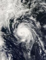
feature developed, and very deep convection developed near the circulation. The cloud pattern continued to organize, and Juan attained hurricane status later on September 26 while located 165 mi (270 km) southeast of Bermuda. As the hurricane moved into an area of warm waters and light wind shear, it strengthened and organized further, and on September 27 Juan attained a peak intensity of 105 mph (165 km/h) while located 635 mi (1,020 km) south of Halifax, Nova Scotia. At its peak strength, the eye of the hurricane was distinct and embedded within a well-defined and round central dense overcast.
Hurricane Juan remained at peak intensity for over 24 hours. After moving northwestward for an extended period of time, it turned and accelerated to the north. On September 28, the eye became less distinct, and the hurricane weakened slightly. Due to its fast forward motion, it had little time to weaken over significantly colder waters, and Juan made landfall between Shad Bay and Prospect (near Halifax) on September 29 with winds of 100 mph (160 km/h). It weakened quickly while moving across the southern Canadian Maritimes, quickly crossing the Nova Scotia peninsula
as a hurricane, before downgrading to a tropical storm as it crossed over Prince Edward Island
several hours later in the early hours of the morning. Later that afternoon, Tropical Storm Juan was absorbed by a large extratropical storm in the northwestern Gulf of Saint Lawrence
.
on September 26, although at that time there were only broad details suggesting the possibility existed for wind and rain across Atlantic Canada
. On September 27, as Juan approached, warning broadcasts on local media in Atlantic Canada were changed accordingly, and the public and emergency officials
in the expected landfall area were told to make preparations for a potential disaster, as the CHC bulletins indicated the possibility existed for significant wind damage and flooding from both heavy rain and storm surge
s, as well as power outages.
On the morning of September 28, the latest reports indicated that Juan would make landfall either as a tropical storm or marginal Category 1 hurricane. Weather broadcasts up to that time gave every indication that the storm would weaken prior to landfall. By 6 p.m. ADT
(2100 UTC), additional warnings were issued, as Juan was expected to make landfall as a strong Category 1 or weak Category 2 hurricane. Most businesses in the areas affected were at the time closed on Sundays, which meant that preparations could not be made at the last minute. Although no large-scale evacuations
were made, local evacuations for low-lying areas were issued on the evening of September 28. In all, several hundred people were affected by these evacuations. Utility
workers also went onto standby before the storm hit, preparing for large-scale power outages.
bore the brunt of the highest sustained winds and strongest wind gusts during the storm; some unofficial estimates have placed gusts as high as 145 mph (230 km/h). Wave-rider weather buoy
s off the entrance of Halifax Harbour snapped their moorings after reportedly recording waves in excess of 65 ft (20 m). Significant erosion occurred on the populated shores of the harbour, particularly in the Bedford Basin
where residential properties and railway tracks received most of the wave action. Storm surges of 5 to 7 feet (1.5 to 2 m) were reported in the harbour; it was the highest surge ever recorded in Halifax Harbour. Rainfall was fairly light due to the fast movement and dry air on the southern side of the storm. There were no rainfall reports greater than 2 inches (52 mm).
Juan caused widespread structural and vegetation damage across the region, particularly in and around the Halifax Regional Municipality. Extensive damage to trees was reported, which blocked many streets and knocked down power lines. Many homes and businesses suffered property damage, particularly roof damage on structures, and some weaker structures were destroyed. HRM estimated that 31% of residential homes suffered some degree of damage and 27% of homes had enough damage to warrant an insurance
claim. In downtown Halifax
, erosion-control boulders the size of garbage cans were hurled from Halifax Harbour onto boardwalks and parking lots and piers. The Victoria General Hospital experienced roof and water damage and was evacuated during the storm, as were numerous tall apartment buildings and other multi-family residences. Billboards and signs were also destroyed, and dozens of vehicles were crushed by trees and other debris. The city's cherished Point Pleasant Park
and Public Gardens
suffered massive loss of trees and remained closed for months.
 At the harbour entrance, on Sambro Island
, a historic building beside the oldest lighthouse in North America was badly damaged and remains unrepaired in 2007. The hurricane caused severe damage to shipping in Halifax Harbour. A visiting recreational schooner named Larinda
was sunk at the wharf beside the Maritime Museum of the Atlantic
and a harbour tour ketch Mar II was driven ashore in Eastern Passage on the opposite side of Halifax Harbour. Another harbour tour vessel, the tern schooner Silva broke from her moorings an caused extensive damage to the Cable Wharf on the Halifax Waterfront. Dozens of smaller yachts where also driven ashore; extensive damage occurred to yacht clubs in the Bedford Basin and Northwest Arm. Dozens of containers were knocked off two container ships at the South End Container Terminal. Wharves on the Halifax and Darmouth waterfront suffered large amounts of damage and several railcars were washed into the harbour at the Dartmouth railway yard; one of the tracks for the double-track main line was washed out in several places along the Bedford Basin near Millview. Coastal flooding was also reported around Halifax Harbour as a result of the storm surge, although inland flooding was minor as rainfall was not heavy due to Juan's fast forward movement.
Less severe property damage was recorded west of the storm's track into St. Margarets Bay
and Mahone Bay
. In addition to Halifax Regional Municipality's urban core, the town of Truro
and all of rural Colchester County
as well as the western part of Pictou County
experienced property damage and power outages from falling trees; numerous barns and other agricultural buildings were damaged east of the storm's path, including a replica of the Hector
in Pictou Harbour. The severity of property damage in the metropolitan areas of Halifax and Dartmouth
of Halifax Regional Municipality initially led some forecasters to believe that Juan was likely a Category 3 hurricane; however, the sustained wind reports did not justify that suggestion. Many of the deciduous trees in central Nova Scotia still had leaves, which magnified the effects of wind damage. Overall, the number of damaged trees was estimated to be in the millions.
Juan claimed six lives (two directly) in Nova Scotia. Both of the direct deaths were due to fallen trees; one was a Halifax paramedic
and the other was a motorist in Enfield
. Three of the four indirect deaths were as a result of a house fire started by candles when electricity was cut, and the fourth was in relief work after the storm.
, it was still a Category 1 hurricane, weakening to a tropical storm as it emerged into the Gulf of Saint Lawrence
. Wind gusts of 86 mph (139 km/h) were reported in Charlottetown and 67 mph (107 km/h) in the Iles de la Madeleine in the Gulf of Saint Lawrence.
Damage was also reported in Prince Edward Island
as a result of the storm, particularly around Charlottetown, where its waterfront sustained heavy wave damage to pleasure craft and sea walls, as well as significant damage to the older urban forest in that city's downtown core. Extensive tree damage was also reported across the island, as well as structural damage to weaker buildings, such as barns and silos. The hurricane left portions of the island without power. The narrow path meant that damage was quite localized; little damage was reported in New Brunswick
or western Prince Edward Island. Voting in the PEI general election
on September 29 was also disrupted, though more than 80% of voters made it to polling stations.
Two deaths were reported in the Gulf of Saint Lawrence off the remote Anticosti Island
in Quebec
. They were fishermen from New Brunswick operating near Anticosti Island.

In the hours following the storm a state of emergency
was declared in Halifax Regional Municipality and parts of neighbouring East Hants Municipal District
and Colchester County
. The Government of Nova Scotia requested that the federal government deploy 600 Canadian Forces
personnel to assist local authorities in HRM with cleanup in the urban area and to assist utility crews with electrical power restoration. Many utility workers, especially those employed by Nova Scotia Power
and the dozens of crews from Maritime Electric
and NB Power
who responded under mutual assistance agreements, worked for almost three weeks without any considerable amount of rest. Many residents praised utility crews for their hard work in restoring the extensive damage.
The devastated Point Pleasant Park
remained closed for cleanup after the storm before re-opening in June 2004, nine months after the storm hit, with a damaged shoreline and almost 85% of its trees removed. A revitalization and reforestation
program began in 2005.
The Government of Nova Scotia pledged $10 million (2003 CAD) in relief money after the hurricane hit, and private contributions were also made quickly after the storm hit. Prince Edward Island also pledged $200,000 (2003 CAD) immediately after the hurricane hit, and the federal government also announced their own package. The Mayor of Toronto at the time, Mel Lastman
, also contributed $50,000 (2003 CAD) to replace damaged trees in Prince Edward Island.
Hurricane Juan alerted residents, governments, utilities, and emergency management agencies throughout Atlantic Canada to improve preparations for devastating events such as hurricanes, especially with climatological data pointing to possible increased frequency of major ocean storms and extratropical cyclones. In addition to Juan, three other storms — Fabian
, Isabel
and Kate
— had a significant effect on land or offshore in Canada
during the 2003 Atlantic hurricane season
.
Preparations and planning have been underway since 2003 and were first tested when Hurricane Ophelia was forecast to brush near Nova Scotia in early September 2005. Hurricane Juan has also resulted in several changes to the Meteorological Service of Canada
's Canadian Hurricane Centre
, which has relocated from a vulnerable and exposed location in an office building in Dartmouth, Nova Scotia
, to a more secure location that can withstand hurricane damage. CHC's hurricane warning system has also been improved; traditionally, CHC did not issue standard hurricane or tropical storm watches or warnings, just high wind and heavy rainfall warnings, which were often not heeded by local residents. Beginning in the 2004 Atlantic hurricane season
, CHC began using standard hurricane warnings for storms potentially affecting Canada. Canada issued its first hurricane warning in 2008 in anticipation of Hurricane Kyle
and in 2009, issued its second hurricane watch in anticipation of Hurricane Bill
.
Because of its effects in Canada, the name Juan was retired in April 2004 and will never again be used for an Atlantic hurricane. Environment Canada noted that its request for retirement was "in consideration of the lost and damaged lives, the impact to economy, and the widespread destruction of trees through out two provinces". It was the first time that the Meteorological Service of Canada had specifically requested a hurricane name be retired. The name was replaced by Joaquin for the 2009 season
.
Tropical cyclone
A tropical cyclone is a storm system characterized by a large low-pressure center and numerous thunderstorms that produce strong winds and heavy rain. Tropical cyclones strengthen when water evaporated from the ocean is released as the saturated air rises, resulting in condensation of water vapor...
that struck the southern part of Atlantic Canada
Atlantic Canada
Atlantic Canada is the region of Canada comprising the four provinces located on the Atlantic coast, excluding Quebec: the three Maritime provinces – New Brunswick, Prince Edward Island, and Nova Scotia – and Newfoundland and Labrador...
in late September 2003. It was the tenth named storm and the sixth hurricane of the 2003 Atlantic hurricane season
2003 Atlantic hurricane season
The 2003 Atlantic hurricane season was an active Atlantic hurricane season with tropical activity before and after the official bounds of the season – the first such occurrence in 50 years. The season produced 21 tropical cyclones, of which 16 developed into named storms; seven...
. Juan formed southeast of Bermuda
Bermuda
Bermuda is a British overseas territory in the North Atlantic Ocean. Located off the east coast of the United States, its nearest landmass is Cape Hatteras, North Carolina, about to the west-northwest. It is about south of Halifax, Nova Scotia, Canada, and northeast of Miami, Florida...
on September 24, 2003 out of a tropical wave
Tropical wave
Tropical waves, easterly waves, or tropical easterly waves, also known as African easterly waves in the Atlantic region, are a type of atmospheric trough, an elongated area of relatively low air pressure, oriented north to south, which move from east to west across the tropics causing areas of...
that tracked into the subtropical Atlantic Ocean
Atlantic Ocean
The Atlantic Ocean is the second-largest of the world's oceanic divisions. With a total area of about , it covers approximately 20% of the Earth's surface and about 26% of its water surface area...
. It strengthened gradually in the warm waters of the Gulf Stream
Gulf Stream
The Gulf Stream, together with its northern extension towards Europe, the North Atlantic Drift, is a powerful, warm, and swift Atlantic ocean current that originates at the tip of Florida, and follows the eastern coastlines of the United States and Newfoundland before crossing the Atlantic Ocean...
, reaching Category 2 strength on the Saffir-Simpson hurricane scale
Saffir-Simpson Hurricane Scale
The Saffir–Simpson Hurricane Scale , or the Saffir–Simpson Hurricane Wind Scale , classifies hurricanes — Western Hemisphere tropical cyclones that exceed the intensities of tropical depressions and tropical storms — into five categories distinguished by the intensities of their sustained winds...
on September 27 while continuing to track northward. It peaked at 105 mph (165 km/h) as it rapidly approached the coast of Nova Scotia
Nova Scotia
Nova Scotia is one of Canada's three Maritime provinces and is the most populous province in Atlantic Canada. The name of the province is Latin for "New Scotland," but "Nova Scotia" is the recognized, English-language name of the province. The provincial capital is Halifax. Nova Scotia is the...
, losing little intensity over the cooler waters. Juan made landfall between Shad Bay
Shad Bay, Nova Scotia
Shad Bay is a rural community on the Chebucto Peninsula in the Halifax Regional Municipality on the shore of the Atlantic Ocean on , 16.3 kilometers from Halifax, in Nova Scotia, Canada.-External links:***...
and Prospect
Prospect, Nova Scotia
Prospect is a Canadian coastal community on the Chebucto Peninsula in Nova Scotia's Halifax Regional Municipality.It borders the Atlantic Ocean approximately 23 kilometers southwest of Halifax off the Prospect Road ....
in the Halifax Regional Municipality early on September 29 as a Category 2 hurricane with maximum sustained winds of 100 mph (162 km/h). Juan retained hurricane strength as it crossed Nova Scotia from south to north before weakening to a tropical storm as it crossed Prince Edward Island
Prince Edward Island
Prince Edward Island is a Canadian province consisting of an island of the same name, as well as other islands. The maritime province is the smallest in the nation in both land area and population...
. It was absorbed by another extratropical
Extratropical cyclone
Extratropical cyclones, sometimes called mid-latitude cyclones or wave cyclones, are a group of cyclones defined as synoptic scale low pressure weather systems that occur in the middle latitudes of the Earth having neither tropical nor polar characteristics, and are connected with fronts and...
low later on September 29 near Anticosti Island
Anticosti Island
Anticosti Island is an island at the outlet of the Saint Lawrence River into the Gulf of Saint Lawrence, in Quebec, Canada, between 49° and 50° N., and between 61° 40' and 64° 30' W. At in size, it is the 90th largest island in the world and 20th largest island in Canada...
in the northern Gulf of Saint Lawrence
Gulf of Saint Lawrence
The Gulf of Saint Lawrence , the world's largest estuary, is the outlet of North America's Great Lakes via the Saint Lawrence River into the Atlantic Ocean...
.
The storm left extensive damage across central Nova Scotia and into Prince Edward Island, with lesser damage east and west of the storm centre. Most of the damage was as a result of the high winds that whipped across the region. Juan resulted in eight fatalities and over CA300,000,000, US200,000,000) in damage. It was described as the worst storm to hit Halifax since 1893
1893 Atlantic hurricane season
The 1893 Atlantic hurricane season ran through the summer and the first half of fall in 1893. The 1893 season was fairly active, with 12 tropical storms forming, 10 of which became hurricanes. Of those, 5 became major hurricanes...
.
Meteorological history
A large tropical waveTropical wave
Tropical waves, easterly waves, or tropical easterly waves, also known as African easterly waves in the Atlantic region, are a type of atmospheric trough, an elongated area of relatively low air pressure, oriented north to south, which move from east to west across the tropics causing areas of...
accompanied by a broad area of low pressure
Low pressure area
A low-pressure area, or "low", is a region where the atmospheric pressure at sea level is below that of surrounding locations. Low-pressure systems form under areas of wind divergence which occur in upper levels of the troposphere. The formation process of a low-pressure area is known as...
moved off the coast of Africa
Africa
Africa is the world's second largest and second most populous continent, after Asia. At about 30.2 million km² including adjacent islands, it covers 6% of the Earth's total surface area and 20.4% of the total land area...
on September 14, 2003. It moved westward, and due to unfavourable upper level wind shear
Wind shear
Wind shear, sometimes referred to as windshear or wind gradient, is a difference in wind speed and direction over a relatively short distance in the atmosphere...
the system remained disorganized. On September 20, while the wave was located about 690 mi
Mile
A mile is a unit of length, most commonly 5,280 feet . The mile of 5,280 feet is sometimes called the statute mile or land mile to distinguish it from the nautical mile...
(1,100 km
Kilometre
The kilometre is a unit of length in the metric system, equal to one thousand metres and is therefore exactly equal to the distance travelled by light in free space in of a second...
) east of the Lesser Antilles
Lesser Antilles
The Lesser Antilles are a long, partly volcanic island arc in the Western Hemisphere. Most of its islands form the eastern boundary of the Caribbean Sea with the Atlantic Ocean, with the remainder located in the southern Caribbean just north of South America...
, convection
Convection
Convection is the movement of molecules within fluids and rheids. It cannot take place in solids, since neither bulk current flows nor significant diffusion can take place in solids....
around the system greatly increased while interacting with the circulation of a large upper-level low, though unfavorable conditions caused it to remain disorganized. The system as a whole moved to the northwest around the upper-level low and developed a mid-level circulation. It interacted with a frontal zone
Surface weather analysis
Surface weather analysis is a special type of weather map that provides a view of weather elements over a geographical area at a specified time based on information from ground-based weather stations...
, and became better organized on September 23 while located 450 mi (725 km) south of Bermuda
Bermuda
Bermuda is a British overseas territory in the North Atlantic Ocean. Located off the east coast of the United States, its nearest landmass is Cape Hatteras, North Carolina, about to the west-northwest. It is about south of Halifax, Nova Scotia, Canada, and northeast of Miami, Florida...
. Later that day, a low-level circulation developed within the system, though its involvement with a nearby frontal zone prevented it being classified a tropical depression. Deep convection increased near the centre on September 24, and it quickly organized to develop banding features
Squall
A squall is a sudden, sharp increase in wind speed which is usually associated with active weather, such as rain showers, thunderstorms, or heavy snow. Squalls refer to an increase in the sustained winds over a short time interval, as there may be higher gusts during a squall event...
and a distinct outflow. Based on its organization, it is estimated the system developed into Tropical Depression Fifteen later that day while located about 345 miles (555 km) southeast of Bermuda. Operationally, the National Hurricane Center
National Hurricane Center
The National Hurricane Center , located at Florida International University in Miami, Florida, is the division of the National Weather Service responsible for tracking and predicting weather systems within the tropics between the Prime Meridian and the 140th meridian west poleward to the 30th...
did not begin issuing advisories until 27 hours after it actually formed.
Initially, the depression possessed tropical
Tropical cyclone
A tropical cyclone is a storm system characterized by a large low-pressure center and numerous thunderstorms that produce strong winds and heavy rain. Tropical cyclones strengthen when water evaporated from the ocean is released as the saturated air rises, resulting in condensation of water vapor...
and subtropical characteristics
Subtropical cyclone
A subtropical cyclone is a weather system that has some characteristics of a tropical and an extratropical cyclone. As early as the 1950s, meteorologists were unclear whether they should be characterized as tropical or extratropical cyclones. They were officially recognized by the National...
; it maintained attachment to a nearby frontal zone, though the organization of the convection and a warm core within the system resulted in classification as a tropical cyclone. Forecasters predicted the depression would only slowly strengthen and reach a peak intensity of 65 mph (105 km/h). However, the depression steadily organized and strengthened into Tropical Storm Juan early on September 25. Later that day, the centre of circulation became embedded within the convection. Juan moved northwestward at around 10 mph (16 km/h), a motion due to the presence of a developing subtropical ridge
Subtropical ridge
The subtropical ridge is a significant belt of high pressure situated around the latitudes of 30°N in the Northern Hemisphere and 30°S in the Southern Hemisphere. It is characterized by mostly calm winds, which acts to reduce air quality under its axis by causing fog overnight, and haze during...
to its east. On September 26, an eye
Eye (cyclone)
The eye is a region of mostly calm weather found at the center of strong tropical cyclones. The eye of a storm is a roughly circular area and typically 30–65 km in diameter. It is surrounded by the eyewall, a ring of towering thunderstorms where the second most severe weather of a cyclone...
feature developed, and very deep convection developed near the circulation. The cloud pattern continued to organize, and Juan attained hurricane status later on September 26 while located 165 mi (270 km) southeast of Bermuda. As the hurricane moved into an area of warm waters and light wind shear, it strengthened and organized further, and on September 27 Juan attained a peak intensity of 105 mph (165 km/h) while located 635 mi (1,020 km) south of Halifax, Nova Scotia. At its peak strength, the eye of the hurricane was distinct and embedded within a well-defined and round central dense overcast.
Hurricane Juan remained at peak intensity for over 24 hours. After moving northwestward for an extended period of time, it turned and accelerated to the north. On September 28, the eye became less distinct, and the hurricane weakened slightly. Due to its fast forward motion, it had little time to weaken over significantly colder waters, and Juan made landfall between Shad Bay and Prospect (near Halifax) on September 29 with winds of 100 mph (160 km/h). It weakened quickly while moving across the southern Canadian Maritimes, quickly crossing the Nova Scotia peninsula
Nova Scotia peninsula
The Nova Scotia peninsula is a peninsula on the Atlantic coast of North America.-Location:The Nova Scotia peninsula is part of the province of Nova Scotia, Canada and is connected to the neighbouring province of New Brunswick through the Isthmus of Chignecto...
as a hurricane, before downgrading to a tropical storm as it crossed over Prince Edward Island
Prince Edward Island
Prince Edward Island is a Canadian province consisting of an island of the same name, as well as other islands. The maritime province is the smallest in the nation in both land area and population...
several hours later in the early hours of the morning. Later that afternoon, Tropical Storm Juan was absorbed by a large extratropical storm in the northwestern Gulf of Saint Lawrence
Gulf of Saint Lawrence
The Gulf of Saint Lawrence , the world's largest estuary, is the outlet of North America's Great Lakes via the Saint Lawrence River into the Atlantic Ocean...
.
Preparations
The first advisories were given by the Canadian Hurricane CentreCanadian Hurricane Centre
The Canadian Hurricane Centre is a division of the Meteorological Service of Canada, an agency of Canada's Department of the Environment, which exists to advise Canadians on the threat of tropical cyclones such as hurricanes and tropical storms...
on September 26, although at that time there were only broad details suggesting the possibility existed for wind and rain across Atlantic Canada
Atlantic Canada
Atlantic Canada is the region of Canada comprising the four provinces located on the Atlantic coast, excluding Quebec: the three Maritime provinces – New Brunswick, Prince Edward Island, and Nova Scotia – and Newfoundland and Labrador...
. On September 27, as Juan approached, warning broadcasts on local media in Atlantic Canada were changed accordingly, and the public and emergency officials
Emergency management
Emergency management is the generic name of an interdisciplinary field dealing with the strategic organizational management processes used to protect critical assets of an organization from hazard risks that can cause events like disasters or catastrophes and to ensure the continuance of the...
in the expected landfall area were told to make preparations for a potential disaster, as the CHC bulletins indicated the possibility existed for significant wind damage and flooding from both heavy rain and storm surge
Storm surge
A storm surge is an offshore rise of water associated with a low pressure weather system, typically tropical cyclones and strong extratropical cyclones. Storm surges are caused primarily by high winds pushing on the ocean's surface. The wind causes the water to pile up higher than the ordinary sea...
s, as well as power outages.
On the morning of September 28, the latest reports indicated that Juan would make landfall either as a tropical storm or marginal Category 1 hurricane. Weather broadcasts up to that time gave every indication that the storm would weaken prior to landfall. By 6 p.m. ADT
Atlantic Standard Time Zone
The Atlantic Standard Time Zone is a geographical region that keeps time by subtracting four hours from either Coordinated Universal Time or Greenwich Mean Time , resulting in UTC-4 or GMT-4...
(2100 UTC), additional warnings were issued, as Juan was expected to make landfall as a strong Category 1 or weak Category 2 hurricane. Most businesses in the areas affected were at the time closed on Sundays, which meant that preparations could not be made at the last minute. Although no large-scale evacuations
Emergency evacuation
Emergency evacuation is the immediate and rapid movement of people away from the threat or actual occurrence of a hazard. Examples range from the small scale evacuation of a building due to a bomb threat or fire to the large scale evacuation of a district because of a flood, bombardment or...
were made, local evacuations for low-lying areas were issued on the evening of September 28. In all, several hundred people were affected by these evacuations. Utility
Public utility
A public utility is an organization that maintains the infrastructure for a public service . Public utilities are subject to forms of public control and regulation ranging from local community-based groups to state-wide government monopolies...
workers also went onto standby before the storm hit, preparing for large-scale power outages.
Nova Scotia
Hurricane Juan's maximum sustained wind speed at landfall in Nova Scotia was measured at 100 mph (160 km/h). The urban concentration surrounding Halifax HarbourHalifax Harbour
Halifax Harbour is a large natural harbour on the Atlantic coast of Nova Scotia, Canada, located in the Halifax Regional Municipality.-Harbour description:The harbour is called Jipugtug by the Mi'kmaq first nation, anglisized as Chebucto...
bore the brunt of the highest sustained winds and strongest wind gusts during the storm; some unofficial estimates have placed gusts as high as 145 mph (230 km/h). Wave-rider weather buoy
Weather buoy
Weather buoys are instruments which collect weather and ocean data within the world's oceans, as well as aiding during emergency response to chemical spills, legal proceedings, and engineering design. Moored buoys have been in used since 1951, while drifting buoys have been used since 1979...
s off the entrance of Halifax Harbour snapped their moorings after reportedly recording waves in excess of 65 ft (20 m). Significant erosion occurred on the populated shores of the harbour, particularly in the Bedford Basin
Bedford Basin
Bedford Basin is a large enclosed bay, forming the northwestern end of Halifax Harbour on Canada's Atlantic coast.-Geography:Geographically, the basin is situated entirely within the Halifax Regional Municipality and is oriented northwest-southeast, measuring approximately 8 kilometres long and 5...
where residential properties and railway tracks received most of the wave action. Storm surges of 5 to 7 feet (1.5 to 2 m) were reported in the harbour; it was the highest surge ever recorded in Halifax Harbour. Rainfall was fairly light due to the fast movement and dry air on the southern side of the storm. There were no rainfall reports greater than 2 inches (52 mm).
Juan caused widespread structural and vegetation damage across the region, particularly in and around the Halifax Regional Municipality. Extensive damage to trees was reported, which blocked many streets and knocked down power lines. Many homes and businesses suffered property damage, particularly roof damage on structures, and some weaker structures were destroyed. HRM estimated that 31% of residential homes suffered some degree of damage and 27% of homes had enough damage to warrant an insurance
Insurance
In law and economics, insurance is a form of risk management primarily used to hedge against the risk of a contingent, uncertain loss. Insurance is defined as the equitable transfer of the risk of a loss, from one entity to another, in exchange for payment. An insurer is a company selling the...
claim. In downtown Halifax
Downtown Halifax
Downtown Halifax is the city centre of the Halifax Regional Municipality, Nova Scotia. Located on the eastern-central portion of the Halifax Peninsula, on Halifax Harbour, it serves as the business, entertainment, and tourism hub of the region.- Municipal:...
, erosion-control boulders the size of garbage cans were hurled from Halifax Harbour onto boardwalks and parking lots and piers. The Victoria General Hospital experienced roof and water damage and was evacuated during the storm, as were numerous tall apartment buildings and other multi-family residences. Billboards and signs were also destroyed, and dozens of vehicles were crushed by trees and other debris. The city's cherished Point Pleasant Park
Point Pleasant Park
Point Pleasant Park is a large, partially forested municipal park at the southern tip of the Halifax peninsula. It once hosted several artillery batteries, and a well-preserved 18th century Martello tower can be found there...
and Public Gardens
Halifax Public Gardens
The Halifax Public Gardens are Victorian era public gardens formally established in 1867, the year of Canadian Confederation. The gardens are located in the Halifax Regional Municipality, Nova Scotia on the Halifax Peninsula near the popular shopping district of Spring Garden Road...
suffered massive loss of trees and remained closed for months.
Sambro Island Lighthouse
Sambro Island Lighthouse is a landfall lighthouse located at the entrance to Halifax Harbour, Nova Scotia, on an island near the community of Sambro in the Halifax Regional Municipality...
, a historic building beside the oldest lighthouse in North America was badly damaged and remains unrepaired in 2007. The hurricane caused severe damage to shipping in Halifax Harbour. A visiting recreational schooner named Larinda
Larinda
The Larinda is a recreational schooner inspired by the 1767 Boston schooner HMS Sultana. It was built over a period of twenty-six years in the backyard of its owner and launched in 1996...
was sunk at the wharf beside the Maritime Museum of the Atlantic
Maritime Museum of the Atlantic
The Maritime Museum of the Atlantic is a Canadian maritime museum located in downtown Halifax, Nova Scotia.The Maritime Museum of the Atlantic is a member institution of the Nova Scotia Museum and is the oldest and largest maritime museum in Canada with a collection of over 30,000 artifacts...
and a harbour tour ketch Mar II was driven ashore in Eastern Passage on the opposite side of Halifax Harbour. Another harbour tour vessel, the tern schooner Silva broke from her moorings an caused extensive damage to the Cable Wharf on the Halifax Waterfront. Dozens of smaller yachts where also driven ashore; extensive damage occurred to yacht clubs in the Bedford Basin and Northwest Arm. Dozens of containers were knocked off two container ships at the South End Container Terminal. Wharves on the Halifax and Darmouth waterfront suffered large amounts of damage and several railcars were washed into the harbour at the Dartmouth railway yard; one of the tracks for the double-track main line was washed out in several places along the Bedford Basin near Millview. Coastal flooding was also reported around Halifax Harbour as a result of the storm surge, although inland flooding was minor as rainfall was not heavy due to Juan's fast forward movement.
Less severe property damage was recorded west of the storm's track into St. Margarets Bay
St. Margarets Bay, Nova Scotia
St. Margarets Bay is a Canadian bay located on the Atlantic coast of Nova Scotia on the border of the Halifax Regional Municipality and Lunenburg County .-Description:...
and Mahone Bay
Mahone Bay
Mahone Bay is a bay located on the Atlantic coast of Nova Scotia, Canada along the eastern end of Lunenburg County.Opening south directly onto the Atlantic, its eastern shore is formed by the Aspotogan Peninsula and its western shore is formed by the First Peninsula...
. In addition to Halifax Regional Municipality's urban core, the town of Truro
Truro, Nova Scotia
-Education:Truro has one high school, Cobequid Educational Centre. Post-secondary options include a campus of the Nova Scotia Community College, as well as the Nova Scotia Agricultural College in the neighboring town of Bible Hill.- Sports :...
and all of rural Colchester County
Colchester County, Nova Scotia
Colchester County is a county in the Canadian province of Nova Scotia.-History:The appellation Colchester was applied in 1780 to the district previously called "Cobequid," and was derived from the town of Colchester in Essex...
as well as the western part of Pictou County
Pictou County, Nova Scotia
Pictou County is a county in the Canadian province of Nova Scotia. It was established in 1835, and was formerly a part of Halifax County from 1759 to 1835. It had a population of 46,513 people in 2006, which represents a decline of 6.3 percent from 1991. It is the sixth most populous county in Nova...
experienced property damage and power outages from falling trees; numerous barns and other agricultural buildings were damaged east of the storm's path, including a replica of the Hector
Hector (ship)
The Hector was a ship famous for having brought the first Scottish settlers to Nova Scotia in 1773.- Career :A full rigged Fluyt, the Hector was employed in local trade in waters of the British Isles as well as the immigrant trade to North America, having made at least one trip ca...
in Pictou Harbour. The severity of property damage in the metropolitan areas of Halifax and Dartmouth
Dartmouth, Nova Scotia
Dartmouth founded in 1750, is a community and planning area of the Halifax Regional Municipality, Nova Scotia. Located on the eastern shore of Halifax Harbour, Dartmouth has been nicknamed the City of Lakes after the large number of lakes located in the city.On April 1, 1996, the provincial...
of Halifax Regional Municipality initially led some forecasters to believe that Juan was likely a Category 3 hurricane; however, the sustained wind reports did not justify that suggestion. Many of the deciduous trees in central Nova Scotia still had leaves, which magnified the effects of wind damage. Overall, the number of damaged trees was estimated to be in the millions.
Juan claimed six lives (two directly) in Nova Scotia. Both of the direct deaths were due to fallen trees; one was a Halifax paramedic
Paramedic
A paramedic is a healthcare professional that works in emergency medical situations. Paramedics provide advanced levels of care for medical emergencies and trauma. The majority of paramedics are based in the field in ambulances, emergency response vehicles, or in specialist mobile units such as...
and the other was a motorist in Enfield
Enfield, Nova Scotia
Enfield, , is a Canadian exurban community located in the Shubenacadie Valley on the border of Hants and Halifax counties. Specifically, Enfield exists in both the East Hants Municipal District and the Halifax Regional Municipality and is divided by the Shubenacadie River.The history of European...
. Three of the four indirect deaths were as a result of a house fire started by candles when electricity was cut, and the fourth was in relief work after the storm.
Rest of Atlantic Canada
When the storm tracked across Nova Scotia and into the Northumberland StraitNorthumberland Strait
The Northumberland Strait is a strait in the southern part of the Gulf of Saint Lawrence in eastern Canada...
, it was still a Category 1 hurricane, weakening to a tropical storm as it emerged into the Gulf of Saint Lawrence
Gulf of Saint Lawrence
The Gulf of Saint Lawrence , the world's largest estuary, is the outlet of North America's Great Lakes via the Saint Lawrence River into the Atlantic Ocean...
. Wind gusts of 86 mph (139 km/h) were reported in Charlottetown and 67 mph (107 km/h) in the Iles de la Madeleine in the Gulf of Saint Lawrence.
Damage was also reported in Prince Edward Island
Prince Edward Island
Prince Edward Island is a Canadian province consisting of an island of the same name, as well as other islands. The maritime province is the smallest in the nation in both land area and population...
as a result of the storm, particularly around Charlottetown, where its waterfront sustained heavy wave damage to pleasure craft and sea walls, as well as significant damage to the older urban forest in that city's downtown core. Extensive tree damage was also reported across the island, as well as structural damage to weaker buildings, such as barns and silos. The hurricane left portions of the island without power. The narrow path meant that damage was quite localized; little damage was reported in New Brunswick
New Brunswick
New Brunswick is one of Canada's three Maritime provinces and is the only province in the federation that is constitutionally bilingual . The provincial capital is Fredericton and Saint John is the most populous city. Greater Moncton is the largest Census Metropolitan Area...
or western Prince Edward Island. Voting in the PEI general election
Prince Edward Island general election, 2003
thumb|Map of PEI's ridings showing winning parties and their popular vote.The Canadian province of Prince Edward Island conducted a general election in September 2003 to elect the 27 members of the Legislative Assembly of Prince Edward Island...
on September 29 was also disrupted, though more than 80% of voters made it to polling stations.
Two deaths were reported in the Gulf of Saint Lawrence off the remote Anticosti Island
Anticosti Island
Anticosti Island is an island at the outlet of the Saint Lawrence River into the Gulf of Saint Lawrence, in Quebec, Canada, between 49° and 50° N., and between 61° 40' and 64° 30' W. At in size, it is the 90th largest island in the world and 20th largest island in Canada...
in Quebec
Quebec
Quebec or is a province in east-central Canada. It is the only Canadian province with a predominantly French-speaking population and the only one whose sole official language is French at the provincial level....
. They were fishermen from New Brunswick operating near Anticosti Island.
Aftermath
In the hours following the storm a state of emergency
State of emergency
A state of emergency is a governmental declaration that may suspend some normal functions of the executive, legislative and judicial powers, alert citizens to change their normal behaviours, or order government agencies to implement emergency preparedness plans. It can also be used as a rationale...
was declared in Halifax Regional Municipality and parts of neighbouring East Hants Municipal District
East Hants, Nova Scotia
East Hants is a municipal district in Hants County, Nova Scotia.With its administrative seat in Milford Station, the district occupies the eastern half of Hants County from the Minas Basin to the boundary with Halifax County, sharing this boundary with the West Hants municipal district...
and Colchester County
Colchester County, Nova Scotia
Colchester County is a county in the Canadian province of Nova Scotia.-History:The appellation Colchester was applied in 1780 to the district previously called "Cobequid," and was derived from the town of Colchester in Essex...
. The Government of Nova Scotia requested that the federal government deploy 600 Canadian Forces
Canadian Forces
The Canadian Forces , officially the Canadian Armed Forces , are the unified armed forces of Canada, as constituted by the National Defence Act, which states: "The Canadian Forces are the armed forces of Her Majesty raised by Canada and consist of one Service called the Canadian Armed Forces."...
personnel to assist local authorities in HRM with cleanup in the urban area and to assist utility crews with electrical power restoration. Many utility workers, especially those employed by Nova Scotia Power
Nova Scotia Power
Nova Scotia Power Inc. is a power generating and delivery company in Nova Scotia. It is privately owned by Emera and regulated by the provincial government via the Nova Scotia Utility and Review Board .-History:...
and the dozens of crews from Maritime Electric
Maritime Electric
Maritime Electric is the supplier of electricity in Prince Edward Island, Canada. Maritime Electric is a public utility regulated by the Island Regulatory and Appeals Commission under the Electric Power Act and the Renewable Energy Act...
and NB Power
NB Power
NB Power , formerly known as New Brunswick Power Corporation and New Brunswick Electric Power Commission is the primary and former monopoly electrical utility in the Canadian province of New Brunswick...
who responded under mutual assistance agreements, worked for almost three weeks without any considerable amount of rest. Many residents praised utility crews for their hard work in restoring the extensive damage.
The devastated Point Pleasant Park
Point Pleasant Park
Point Pleasant Park is a large, partially forested municipal park at the southern tip of the Halifax peninsula. It once hosted several artillery batteries, and a well-preserved 18th century Martello tower can be found there...
remained closed for cleanup after the storm before re-opening in June 2004, nine months after the storm hit, with a damaged shoreline and almost 85% of its trees removed. A revitalization and reforestation
Reforestation
Reforestation is the natural or intentional restocking of existing forests and woodlands that have been depleted, usually through deforestation....
program began in 2005.
The Government of Nova Scotia pledged $10 million (2003 CAD) in relief money after the hurricane hit, and private contributions were also made quickly after the storm hit. Prince Edward Island also pledged $200,000 (2003 CAD) immediately after the hurricane hit, and the federal government also announced their own package. The Mayor of Toronto at the time, Mel Lastman
Mel Lastman
Melvin Douglas "Mel" Lastman , nicknamed "Mayor Mel", is a former businessman and politician. He is the founder of the Bad Boy Furniture chain. He served as the mayor of the former city of North York, Ontario, Canada from 1972 until 1997. At the end of 1997, North York, along with five other...
, also contributed $50,000 (2003 CAD) to replace damaged trees in Prince Edward Island.
Hurricane Juan alerted residents, governments, utilities, and emergency management agencies throughout Atlantic Canada to improve preparations for devastating events such as hurricanes, especially with climatological data pointing to possible increased frequency of major ocean storms and extratropical cyclones. In addition to Juan, three other storms — Fabian
Hurricane Fabian
Hurricane Fabian was a powerful Cape Verde-type hurricane that hit Bermuda in early September during the 2003 Atlantic hurricane season. Fabian, the sixth named storm, fourth hurricane, and first major hurricane of the season, developed from a tropical wave in the tropical Atlantic Ocean on August 25...
, Isabel
Hurricane Isabel
Hurricane Isabel was the costliest and deadliest hurricane in the 2003 Atlantic hurricane season. The ninth named storm, fifth hurricane, and second major hurricane of the season, Isabel formed near the Cape Verde Islands from a tropical wave on September 6 in the tropical Atlantic Ocean...
and Kate
Hurricane Kate (2003)
Hurricane Kate was the second-longest tropical cyclone in the 2003 Atlantic hurricane season. The eleventh tropical storm, fifth hurricane, and third major hurricane of the season, Kate developed from a tropical wave in the central tropical Atlantic on September 25. Its unusual track included four...
— had a significant effect on land or offshore in Canada
Canada
Canada is a North American country consisting of ten provinces and three territories. Located in the northern part of the continent, it extends from the Atlantic Ocean in the east to the Pacific Ocean in the west, and northward into the Arctic Ocean...
during the 2003 Atlantic hurricane season
2003 Atlantic hurricane season
The 2003 Atlantic hurricane season was an active Atlantic hurricane season with tropical activity before and after the official bounds of the season – the first such occurrence in 50 years. The season produced 21 tropical cyclones, of which 16 developed into named storms; seven...
.
Preparations and planning have been underway since 2003 and were first tested when Hurricane Ophelia was forecast to brush near Nova Scotia in early September 2005. Hurricane Juan has also resulted in several changes to the Meteorological Service of Canada
Meteorological Service of Canada
The Meteorological Service of Canada , also known as "The Canadian Weather Service", is a division of Environment Canada, which primarily provides public meteorological information and weather forecasts and warnings of severe weather and other environmental hazards...
's Canadian Hurricane Centre
Canadian Hurricane Centre
The Canadian Hurricane Centre is a division of the Meteorological Service of Canada, an agency of Canada's Department of the Environment, which exists to advise Canadians on the threat of tropical cyclones such as hurricanes and tropical storms...
, which has relocated from a vulnerable and exposed location in an office building in Dartmouth, Nova Scotia
Dartmouth, Nova Scotia
Dartmouth founded in 1750, is a community and planning area of the Halifax Regional Municipality, Nova Scotia. Located on the eastern shore of Halifax Harbour, Dartmouth has been nicknamed the City of Lakes after the large number of lakes located in the city.On April 1, 1996, the provincial...
, to a more secure location that can withstand hurricane damage. CHC's hurricane warning system has also been improved; traditionally, CHC did not issue standard hurricane or tropical storm watches or warnings, just high wind and heavy rainfall warnings, which were often not heeded by local residents. Beginning in the 2004 Atlantic hurricane season
2004 Atlantic hurricane season
The 2004 Atlantic hurricane season officially began on June 1, 2004, and lasted until November 30, 2004. These dates conventionally delimit the period of each year when most tropical cyclones form in the Atlantic basin...
, CHC began using standard hurricane warnings for storms potentially affecting Canada. Canada issued its first hurricane warning in 2008 in anticipation of Hurricane Kyle
Hurricane Kyle (2008)
Hurricane Kyle was the eleventh tropical storm and sixth hurricane of the 2008 Atlantic hurricane season. It formed from a strong tropical disturbance that tracked across the northeastern Caribbean Sea in the third week of September...
and in 2009, issued its second hurricane watch in anticipation of Hurricane Bill
Hurricane Bill (2009)
Hurricane Bill was a relatively large Atlantic tropical cyclone, attaining a maximum gale-diameter of 460 mi . A Cape Verde type hurricane, Bill originated from a tropical wave that emerged from the western coast of Africa on August 12, and organized into a tropical depression near the Cape...
.
Because of its effects in Canada, the name Juan was retired in April 2004 and will never again be used for an Atlantic hurricane. Environment Canada noted that its request for retirement was "in consideration of the lost and damaged lives, the impact to economy, and the widespread destruction of trees through out two provinces". It was the first time that the Meteorological Service of Canada had specifically requested a hurricane name be retired. The name was replaced by Joaquin for the 2009 season
2009 Atlantic hurricane season
The 2009 Atlantic hurricane season was a below-average year, unlike the 2009 Pacific hurricane season, which was above average, both due to a moderate El Niño. During this year, nine tropical storms formed, the fewest since the 1997 season.An average season has ten tropical storms, six hurricanes...
.
See also
- List of Atlantic hurricanes
- List of retired Atlantic hurricane names
- White JuanWhite JuanWhite Juan is the unofficial name given to the Atlantic Canada blizzard of February 2004, a strong nor'easter that affected most of Atlantic Canada between February 17 and 20, 2004—only five months after Hurricane Juan devastated central Nova Scotia and Prince Edward Island.The storm dropped...
- Timeline of the 2003 Atlantic hurricane seasonTimeline of the 2003 Atlantic hurricane seasonThe 2003 Atlantic hurricane season was an active Atlantic hurricane season with tropical activity before and after the official bounds of the season – the first such occurrence in 50 years. The season officially began on June 1, 2003 and ended on November 30...
- List of storms in the 2003 Atlantic hurricane season