

Halifax Harbour
Encyclopedia

Atlantic Ocean
The Atlantic Ocean is the second-largest of the world's oceanic divisions. With a total area of about , it covers approximately 20% of the Earth's surface and about 26% of its water surface area...
coast of Nova Scotia
Nova Scotia
Nova Scotia is one of Canada's three Maritime provinces and is the most populous province in Atlantic Canada. The name of the province is Latin for "New Scotland," but "Nova Scotia" is the recognized, English-language name of the province. The provincial capital is Halifax. Nova Scotia is the...
, Canada
Canada
Canada is a North American country consisting of ten provinces and three territories. Located in the northern part of the continent, it extends from the Atlantic Ocean in the east to the Pacific Ocean in the west, and northward into the Arctic Ocean...
, located in the Halifax Regional Municipality
Halifax Regional Municipality, Nova Scotia
Halifax Regional Municipality is the capital of the province of Nova Scotia, Canada. The Regional Municipality had a 2006 census population of 372,679, while the metropolitan area had a 2010 estimated population of 403,188, and the urban area of Halifax had a population of 282,924...
.
Harbour description
The harbour is called Jipugtug by the Mi'kmaq first nation, anglisized as Chebucto. It runs in a northwest-southeast direction.Based on average vessel speeds, the harbour is strategically located approximately one hour's sailing time north of the Great Circle Route between the Eastern Seaboard
Eastern seaboard
An Eastern seaboard can mean any easternmost part of a continent, or its countries, states and/or cities.Eastern seaboard may also refer to:* East Coast of Australia* East Coast of the United States* Eastern Seaboard of Thailand-See also:...
and Europe
Europe
Europe is, by convention, one of the world's seven continents. Comprising the westernmost peninsula of Eurasia, Europe is generally 'divided' from Asia to its east by the watershed divides of the Ural and Caucasus Mountains, the Ural River, the Caspian and Black Seas, and the waterways connecting...
. As such, it is the first inbound and last outbound port of call in eastern North America
North America
North America is a continent wholly within the Northern Hemisphere and almost wholly within the Western Hemisphere. It is also considered a northern subcontinent of the Americas...
with transcontinental rail connections.
The harbour is largely formed by a drowned glacial valley which succumbed to sea level rise since glaciation. The Sackville River now empties into the upper end of the harbour in Bedford Basin
Bedford Basin
Bedford Basin is a large enclosed bay, forming the northwestern end of Halifax Harbour on Canada's Atlantic coast.-Geography:Geographically, the basin is situated entirely within the Halifax Regional Municipality and is oriented northwest-southeast, measuring approximately 8 kilometres long and 5...
, however its original river bed has been charted by the Canadian Hydrographic Service
Canadian Hydrographic Service
The Canadian Hydrographic Service is Canada's hydrographic office, with responsibility for performing hydrographic surveys and publishing paper and electronic nautical charts...
throughout the length of the harbour and beyond.
The harbour includes the following geographic areas:
- Northwest ArmNorthwest ArmThe Northwest Arm, originally named Sandwich River, is an inlet in eastern Canada off the Atlantic Ocean in Nova Scotia's Halifax Regional Municipality.-Geography:...
Another drowned river valley now largely used by pleasure boats. - The Narrows A constricted passage to Bedford Basin.
- Bedford BasinBedford BasinBedford Basin is a large enclosed bay, forming the northwestern end of Halifax Harbour on Canada's Atlantic coast.-Geography:Geographically, the basin is situated entirely within the Halifax Regional Municipality and is oriented northwest-southeast, measuring approximately 8 kilometres long and 5...
A sheltered bay and the largest part of the harbour.
Islands
The harbour is home to several small islands.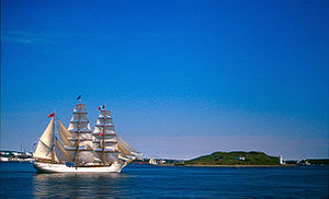
McNabs Island
McNabs Island is the largest island in Halifax Harbour located in Halifax Regional Municipality, Nova Scotia, Canada. It played a major role in defending Halifax Harbour and is now a provincial park...
. The largest island entirely within the harbour limits is Georges Island, a glacial drumlin
Drumlin
A drumlin, from the Irish word droimnín , first recorded in 1833, is an elongated whale-shaped hill formed by glacial ice acting on underlying unconsolidated till or ground moraine.-Drumlin formation:...
similar to its dryland counterpart at Citadel Hill. Several small islands are located in the Bedford Basin
Bedford Basin
Bedford Basin is a large enclosed bay, forming the northwestern end of Halifax Harbour on Canada's Atlantic coast.-Geography:Geographically, the basin is situated entirely within the Halifax Regional Municipality and is oriented northwest-southeast, measuring approximately 8 kilometres long and 5...
near Bedford
Bedford, Nova Scotia
Bedford is a community in the Halifax Regional Municipality, Nova Scotia, Canada. It was an independent town from 1980-1996. Bedford lies on the northwestern end of Bedford Basin, an extension of the Halifax Harbour...
and Burnside
Burnside, Nova Scotia
Burnside is a Canadian urban neighbourhood located along the northeast shore of Bedford Basin in Nova Scotia's Halifax Regional Municipality.Officially still termed a dispersed rural community, Burnside has been the location of a major concentration of industry and commercial development since the...
.
In the Northwest Arm, there is a small peninsula known as Deadman's Island
Deadman's Island, Halifax
Deadman's Island is a small peninsula containing a cemetery and park located in the Northwest Arm of Halifax Harbour in Nova Scotia, Canada.It was first known as "Target Island" after use by the British military for target practice....
, named for the burial location of War of 1812
War of 1812
The War of 1812 was a military conflict fought between the forces of the United States of America and those of the British Empire. The Americans declared war in 1812 for several reasons, including trade restrictions because of Britain's ongoing war with France, impressment of American merchant...
prisoners of war. Just 200 m west of Deadman's Island is the equally small Melville Island, which is connected to the mainland by road. Melville Island forms the eastern boundary of Melville Cove and is also the location of the Armdale Yacht Club
Armdale Yacht Club
The Armdale Yacht Club is a yacht club located on Melville Island at the head of Halifax Harbour's Northwest Arm in Nova Scotia Canada. Although only 60 years old itself, the club's property has a history dating to 1732.-Melville Island:...
. Melville Cove is also the name of the adjacent residential community
Melville Cove, Halifax
Melville Cove is a Residential subdivision in Armdale on Mainland Halifax within the Halifax Regional Municipality Nova Scotia on the shore of the Northwest Arm in Halifax Harbour .-References:*...
.
Although outside the defined harbour limits, Lawlor Island
Lawlor Island
Lawlor Island is a small island near the mouth of Halifax Harbour. Measuring approximately 55 hectares, it is located opposite MacCormacks Beach in Eastern Passage and McNabs Island in the Halifax Regional Municipality, Nova Scotia...
and Devils Island
Devils Island, Nova Scotia
Devils Island, Nova Scotia is located on the northeast entrance of Halifax Harbour off the coast of the Halifax Regional Municipality near the community of Eastern Passage, Nova Scotia. The name originated from an early French merchant and was first spelled Deville's Island...
are also frequently included in descriptions of Halifax Harbour and the surrounding area.
Navigation
Halifax's official harbour limit for navigational purposes is delineated by a line running from Herring CoveHerring Cove, Nova Scotia
Herring Cove is a Canadian suburban and fishing community in Nova Scotia's Halifax Regional Municipality. It is situated on the eastern shore of the Chebucto Peninsula, 15 kilometres south of Downtown Halifax...
on the west side of the main channel, to the northern end of McNabs Island, then from McNabs Island across the Eastern Passage to the actual community of Eastern Passage
Eastern Passage, Nova Scotia
Eastern Passage is a Canadian urban community in Nova Scotia's Halifax Regional Municipality.Located at the southeastern edge of Halifax Harbour, fronting the Atlantic Ocean, Eastern Passage derives its name from the narrow strait separating the mainland from McNabs Island and Lawlor Island, both...
on the east side of the island. The harbour is marked by an extensive network of buoys and lighthouse
Lighthouse
A lighthouse is a tower, building, or other type of structure designed to emit light from a system of lamps and lenses or, in older times, from a fire, and used as an aid to navigation for maritime pilots at sea or on inland waterways....
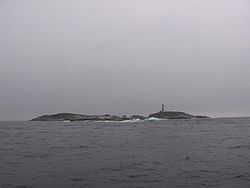
s, starting with Sambro Island Lighthouse
Sambro Island Lighthouse
Sambro Island Lighthouse is a landfall lighthouse located at the entrance to Halifax Harbour, Nova Scotia, on an island near the community of Sambro in the Halifax Regional Municipality...
at the harbour approaches, the oldest operating lighthouse in North America
North America
North America is a continent wholly within the Northern Hemisphere and almost wholly within the Western Hemisphere. It is also considered a northern subcontinent of the Americas...
.
Shallow draught vessels (less than 2.5 m, 8.5 ft) may use the Eastern Passage, which runs on the east side of McNabs Island; however, continuous silting makes charted depths unreliable.
Large vessels have compulsory pilotage, with harbour pilots
Pilot boat
A Pilot Boat is a type of boat used to transport pilots between land and the inbound or outbound ships that they are piloting.-History:The origins of the word pilot probably disseminates from the Latin word pilota, a variation of pedota, the plural of pēdón which translates as oar...
boarding at the pilot station off Chebucto Head. Vessels wishing to transit The Narrows between the outer harbour and Bedford Basin must travel one at a time; this rule was established after the disastrous Halifax Explosion
Halifax Explosion
The Halifax Explosion occurred on Thursday, December 6, 1917, when the city of Halifax, Nova Scotia, Canada, was devastated by the huge detonation of the SS Mont-Blanc, a French cargo ship, fully loaded with wartime explosives, which accidentally collided with the Norwegian SS Imo in "The Narrows"...
of December 6, 1917 when a collision between the French munitions ship Mont-Blanc
SS Mont-Blanc
The SS Mont-Blanc was a French freighter which exploded while carrying ammunition in Halifax Harbour on December 6, 1917 causing the Halifax Explosion which killed 2000 people. The explosion was caused by a collision with the Norwegian ship SS Imo...
and the Norwegian Imo destroyed part of Halifax and Dartmouth
Dartmouth, Nova Scotia
Dartmouth founded in 1750, is a community and planning area of the Halifax Regional Municipality, Nova Scotia. Located on the eastern shore of Halifax Harbour, Dartmouth has been nicknamed the City of Lakes after the large number of lakes located in the city.On April 1, 1996, the provincial...
.
Canada's navy, Maritime Command
Canadian Forces Maritime Command
The Royal Canadian Navy , is the naval force of Canada. The RCN is one of three environmental commands within the unified Canadian Forces. Operating 33 warships and several auxiliary vessels, the Royal Canadian Navy consists of 8,500 Regular Force and 5,100 Primary Reserve sailors, supported by...
(MARCOM) maintains a large base housing its Atlantic fleet Maritime Forces Atlantic
Maritime Forces Atlantic
In the Canadian Forces, Maritime Forces Atlantic is responsible for the fleet and operations of the Royal Canadian Navy in the Atlantic Ocean and Arctic Ocean. The Commander of MARLANT is a two-star Rear Admiral....
(MARLANT) along the western side of The Narrows, as well as an ammunition depot (CFAD Bedford) on the northeastern shore of Bedford Basin. There are strict security regulations relating to vessels navigating near MARCOM facilities and anchorages.
There are two large suspension bridges crossing The Narrows:
- the Angus L. Macdonald BridgeAngus L. Macdonald BridgeThe Angus L. Macdonald Bridge, locally known as "the old bridge", is a suspension bridge crossing Halifax Harbour in Nova Scotia, Canada; it opened on April 2, 1955....
, opening in 1955 - the A. Murray MacKay BridgeA. Murray MacKay BridgeThe A. Murray MacKay Bridge locally known as "the new bridge" is the second suspension bridge linking the Halifax Peninsula with Dartmouth, Nova Scotia, and opened on July 10, 1970....
, opening in 1970
Port facilities
After Confederation in 1867, boosters of Halifax expected federal help to make the city's natural harbor Canada's official winter port and a gateway for trade with Europe. Halifax's advantages included its location just off the Great Circle route made it the closest to Europe of any mainland North American port. But the new Intercolonial Railway (ICR) took an indirect, southerly route for military and political reasons, and the national government made little effort to promote Halifax as Canada's winter port. Ignoring appeals to nationalism and the ICR's own attempts to promote traffic to Halifax, most Canadian exporters sent their wares by train though Boston or Portland. No one was interested in financing the large-scale port facilities Halifax lacked. It took the First World War to at last boost Halifax's harbor into prominence on the North Atlantic.The Halifax Port Authority
Halifax Port Authority
The Halifax Port Authority is a port authority operating as a not-for-profit Crown corporation of the Government of Canada. HPA has responsibility for all federally-owned waterfront properties on Halifax Harbour in Nova Scotia's Halifax Regional Municipality.The HPA was created on March 1, 1999...
is a federally-appointed agency which administers and operates various port properties on the harbour. Previously run by the National Harbours Board, the HPA is now a locally-run organization.
HPA facilities include:
- South End Container Terminal - Piers 36-42 (currently operated by Halterm Limited, with several gantryGantry craneGantry cranes, bridge cranes, and overhead cranes, are all types of cranes which lift objects by a hoist which is fitted in a hoist trolley and can move horizontally on a rail or pair of rails fitted under a beam...
and post-PanamaxPanamaxPanamax and New Panamax are popular terms for the size limits for ships traveling through the Panama Canal. Formally, the limits and requirements are published by the Panama Canal Authority titled "Vessel Requirements"...
cranes) - Halifax Grain Elevator
- Ocean Terminals - Piers 23-34
- Seawall - Piers 20-22, Cruise ShipCruise shipA cruise ship or cruise liner is a passenger ship used for pleasure voyages, where the voyage itself and the ship's amenities are part of the experience, as well as the different destinations along the way...
Pavilion and Pier 21Pier 21Pier 21, a former ocean liner terminal, is Canada's National Museum of Immigration in Halifax, Nova Scotia.It operated as an ocean liner terminal and immigration shed from 1928 to 1971 and became an immigration museum in 1999. Pier 21 is Canada's last remaining ocean immigration shed...
museum - Richmond Terminals - Piers 9 and 9A
- Richmond Offshore Terminals - Piers 9B-9D (multi-user supply base for offshore oil and gas exploration/production)
- Fairview Cove Container Terminal - (currently operated by Cerescorp)
- National Gypsum Wharf - (currently operated by National Gypsum to serve Wrights Cove gypsum terminal)
- Woodside Atlantic Wharf - (vessel lay-up and repair, oil platformOil platformAn oil platform, also referred to as an offshore platform or, somewhat incorrectly, oil rig, is a lаrge structure with facilities to drill wells, to extract and process oil and natural gas, and to temporarily store product until it can be brought to shore for refining and marketing...
servicing) - Imperial Oil Wharves - (currently operated by Imperial OilImperial OilImperial Oil Limited is Canada's largest petroleum company. The company is engaged in the exploration, production and sale of crude oil and natural gas. It is controlled by US based ExxonMobil, which owns 69.6% of its stock...
to serve Dartmouth refineryRefineryA refinery is a production facility composed of a group of chemical engineering unit processes and unit operations refining certain materials or converting raw material into products of value.-Types of refineries:Different types of refineries are as follows:...
) - Ultramar Oil Wharves - (currently operated by UltramarUltramarUltramar is a Canadian oil refining and marketing company formerly known as Golden Eagle or Aigle d'or. Its head office is in Montreal...
to serve the petroleum storage facility) - Eastern Passage Autoport - (currently operated by CNCanadian National RailwayThe Canadian National Railway Company is a Canadian Class I railway headquartered in Montreal, Quebec. CN's slogan is "North America's Railroad"....
)
All HPA facilities are serviced by CN. It provides on-dock daily train service to Montreal
Montreal
Montreal is a city in Canada. It is the largest city in the province of Quebec, the second-largest city in Canada and the seventh largest in North America...
, Toronto
Toronto
Toronto is the provincial capital of Ontario and the largest city in Canada. It is located in Southern Ontario on the northwestern shore of Lake Ontario. A relatively modern city, Toronto's history dates back to the late-18th century, when its land was first purchased by the British monarchy from...
, Detroit and Chicago
Chicago
Chicago is the largest city in the US state of Illinois. With nearly 2.7 million residents, it is the most populous city in the Midwestern United States and the third most populous in the US, after New York City and Los Angeles...
. The railway also operates the Halifax Intermodal Terminal (HIT) adjacent to the Richmond Terminals.
In addition to HPA facilities, the following users have port facilities:
- Irving Shipbuilding operates the Halifax Shipyard, a medium-sized vessel construction and repair yard. The yard contains two floating drydocks (the largest is Panamax size) plus one graving dock and various shore-based operations.
- MARLANT operates the HMC Dockyard, Dockyard Annex, CFAD Bedford, and York Redoubt through CFB HalifaxCFB HalifaxCanadian Forces Base Halifax is Canada's east coast navy base and home port to the Atlantic fleet, known as Maritime Forces Atlantic....
. There are also military docking facilities located adjacent to the Shearwater HeliportCFB ShearwaterCanadian Forces Base Shearwater , commonly referred to as CFB Shearwater, was a Canadian Forces Base located in Shearwater, Nova Scotia on the eastern shore of Halifax Harbour in the Halifax Regional Municipality....
. - Canadian Coast GuardCanadian Coast GuardThe Canadian Coast Guard is the coast guard of Canada. It is a federal agency responsible for providing maritime search and rescue , aids to navigation, marine pollution response, marine radio, and icebreaking...
operates CCG Base Dartmouth, housing part of the Atlantic and Arctic fleets as well as pollution response and navigation aids maintenance facilities. - Bedford Institute of OceanographyBedford Institute of OceanographyThe Bedford Institute of Oceanography is a major Canadian government ocean research facility located in Dartmouth in the Halifax Regional Municipality in Nova Scotia. The Bedford Institute of Oceanography is the largest ocean research station in Canada...
maintains docking facilities for various government scientific vessels. Shannon Hill, above the BIO campus is also home to CCG's "Halifax Marine Communications and Traffic Services" which operates Halifax Coast Guard Radio and the Vessel Traffic Services (VTS) centre ("Halifax Traffic"), providing continuous radar coverage of all harbour activity.
- There are several marinas on the harbour:
- Armdale Yacht ClubArmdale Yacht ClubThe Armdale Yacht Club is a yacht club located on Melville Island at the head of Halifax Harbour's Northwest Arm in Nova Scotia Canada. Although only 60 years old itself, the club's property has a history dating to 1732.-Melville Island:...
(Northwest ArmNorthwest ArmThe Northwest Arm, originally named Sandwich River, is an inlet in eastern Canada off the Atlantic Ocean in Nova Scotia's Halifax Regional Municipality.-Geography:...
) - Bedford Basin Yacht Club (Bedford)
- Dartmouth Yacht ClubDartmouth Yacht ClubThe Dartmouth Yacht Club is a yacht club located in Wright's Cove in Halifax Harbour's Bedford Basin next to Burnside Industrial Park in Dartmouth , Nova Scotia Canada. The club's has a history dating to 1962.-External links:*...
(Wrights Cove)- BurnsideBurnside, Nova ScotiaBurnside is a Canadian urban neighbourhood located along the northeast shore of Bedford Basin in Nova Scotia's Halifax Regional Municipality.Officially still termed a dispersed rural community, Burnside has been the location of a major concentration of industry and commercial development since the... - Royal Nova Scotia Yacht SquadronRoyal Nova Scotia Yacht SquadronThe Royal Nova Scotia Yacht Squadron is a yacht club located on the Northwest Arm of Halifax Harbour in Halifax, Nova Scotia. Primarily a sailing club, the RNSYS also offers instructional programs and on water activities for all ages....
(Northwest ArmNorthwest ArmThe Northwest Arm, originally named Sandwich River, is an inlet in eastern Canada off the Atlantic Ocean in Nova Scotia's Halifax Regional Municipality.-Geography:...
) - Shearwater Yacht Club (ShearwaterShearwater, Nova ScotiaShearwater is a Canadian Forces base outside of Dartmouth, Nova Scotia. It is located between Woodside and Eastern Passage. Shearwater is divided into two separate sections by Pleasant Street, and referred to locally as the Upper and Lower Base, respectively, but is part of the same complex...
) - St. Mary's Boat Club (Northwest ArmNorthwest ArmThe Northwest Arm, originally named Sandwich River, is an inlet in eastern Canada off the Atlantic Ocean in Nova Scotia's Halifax Regional Municipality.-Geography:...
) - Waegwoltic Club (Northwest ArmNorthwest ArmThe Northwest Arm, originally named Sandwich River, is an inlet in eastern Canada off the Atlantic Ocean in Nova Scotia's Halifax Regional Municipality.-Geography:...
)
- Armdale Yacht Club
- There are 2 Automated Weather stationWeather stationA weather station is a facility, either on land or sea, with instruments and equipment for observing atmospheric conditions to provide information for weather forecasts and to study the weather and climate. The measurements taken include temperature, barometric pressure, humidity, wind speed, wind...
s within the harbour- McNabs IslandMcNabs IslandMcNabs Island is the largest island in Halifax Harbour located in Halifax Regional Municipality, Nova Scotia, Canada. It played a major role in defending Halifax Harbour and is now a provincial park...
- Weather buoyWeather buoyWeather buoys are instruments which collect weather and ocean data within the world's oceans, as well as aiding during emergency response to chemical spills, legal proceedings, and engineering design. Moored buoys have been in used since 1951, while drifting buoys have been used since 1979...
Station 44258
- McNabs Island
Pollution
Halifax Harbour has long been polluted as a result of two centuries of direct raw sewage discharge into its waters. The harbour's deep water, tidal dispersal of surface wastes and a relatively small population of the city of HalifaxCity of Halifax
Halifax is a city in Canada, which was the capital of the province of Nova Scotia and shire town of Halifax County. It was the largest city in Atlantic Canada until it was amalgamated into Halifax Regional Municipality in 1996...
resulted in the harbour's presenting few health concerns until the late 20th century when sewage build-up caused the shut-down of all harbour beaches.
The Halifax Harbour Solutions Project, initiated in the year 2000, was the culmination of three decades of discussion and planning regarding how the urban area would solve the expensive problem of sewage treatment and disposal. The $400 million project was expected to be completed in late 2008 when the final of three new treatment plants was opened.
Testing of harbour waters in July 2008, with two of the three sewage treatment plants on-line, indicated that they are safe for swimming. Municipal public beaches at Black Rock Beach in Point Pleasant Park
Point Pleasant Park
Point Pleasant Park is a large, partially forested municipal park at the southern tip of the Halifax peninsula. It once hosted several artillery batteries, and a well-preserved 18th century Martello tower can be found there...
and at the Dingle Beach in Sir Sandford Fleming Park
Sir Sandford Fleming Park
Sir Sandford Fleming Park, known locally as The Dingle Park , is a urban park located in the Halifax Regional Municipality in the subdivision of Jollimore, Canada....
were officially re-opened on Saturday, August 2, 2008 (Natal Day weekend) after a 30-year closure due to sewage contamination in the water. Lifeguards are now providing supervision during regular hours through to Labour Day weekend. However repeated breakdowns in the new system have resulted in swimming bans being regularly re-imposed and periodic resumption of raw sewage discharge. From early 2009 on swimming was no longer allowed in the harbour because the plant flooded and stopped working. On the weekend of July 4, 2010 some beaches (like Black Rock Beach) reopened.
Shipwrecks
Halifax Harbour is noted for many shipwrecks both in the inner and outer harbour. A few ships were sunk at the edge of the harbour approaches during World War IIWorld War II
World War II, or the Second World War , was a global conflict lasting from 1939 to 1945, involving most of the world's nations—including all of the great powers—eventually forming two opposing military alliances: the Allies and the Axis...
by German U-Boat
U-boat
U-boat is the anglicized version of the German word U-Boot , itself an abbreviation of Unterseeboot , and refers to military submarines operated by Germany, particularly in World War I and World War II...
s but the vast majority were claimed by harbour accidents. Mapping of the harbour revealed about 45 shipwrecks in the harbour. Near the mouth of the harbour, over 50 magnetic anomalies have been discovered, most of which also represent shipwrecks with many others buried underneath the muddy sediments. All historic shipwrecks in Halifax Harbour are protected by Nova Scotia's Special Places Act which makes it illegal to remove artifacts without a permit. Noteworthy wrecks include (with sinking dates):
- Athelviking: Torpedoed by German submarineSubmarineA submarine is a watercraft capable of independent operation below the surface of the water. It differs from a submersible, which has more limited underwater capability...
U-1232German submarine U-1232U-1232 was a Type IX U-boat of the German Kriegsmarine during World War II. On 14 January 1945, the boat torpedoed and sank three ships within 13 minutes near Halifax Harbour off the Atlantic coast of Canada....
on January 14, 1945. - Barge in Bedford Basin as the result of the Magazine explosion of 1945.
- SS British Freedom - sunk the same day as the Athelviking by U-1232.
- Clayoquot, December 24, 1944
- Deliverance, June 15, 1917
- Erg, July 6, 1943: 19 lives lost.
- Good Hope, March 16, 1929
- Governor Cornwallis, December 22, 1944 by fire
- Gertrude de Costa, March 18, 1950
- Havana, April 26, 1906: Rammed by the steamer Strathcona, at night while anchored.
- Kaaparen, June 14, 1942: Collision while forming a convoy.
- Fragments of blown up in the Halifax ExplosionHalifax ExplosionThe Halifax Explosion occurred on Thursday, December 6, 1917, when the city of Halifax, Nova Scotia, Canada, was devastated by the huge detonation of the SS Mont-Blanc, a French cargo ship, fully loaded with wartime explosives, which accidentally collided with the Norwegian SS Imo in "The Narrows"...
, the world's largest man-made accidental explosion.