

Bedford Basin
Encyclopedia
Bay
A bay is an area of water mostly surrounded by land. Bays generally have calmer waters than the surrounding sea, due to the surrounding land blocking some waves and often reducing winds. Bays also exist as an inlet in a lake or pond. A large bay may be called a gulf, a sea, a sound, or a bight...
, forming the northwestern end of Halifax Harbour
Halifax Harbour
Halifax Harbour is a large natural harbour on the Atlantic coast of Nova Scotia, Canada, located in the Halifax Regional Municipality.-Harbour description:The harbour is called Jipugtug by the Mi'kmaq first nation, anglisized as Chebucto...
on Canada
Canada
Canada is a North American country consisting of ten provinces and three territories. Located in the northern part of the continent, it extends from the Atlantic Ocean in the east to the Pacific Ocean in the west, and northward into the Arctic Ocean...
's Atlantic
Atlantic Ocean
The Atlantic Ocean is the second-largest of the world's oceanic divisions. With a total area of about , it covers approximately 20% of the Earth's surface and about 26% of its water surface area...
coast.
Geography
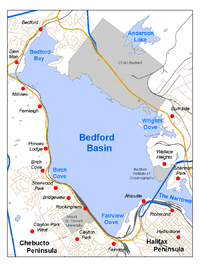
Geographically, the basin is situated entirely within the Halifax Regional Municipality and is oriented northwest-southeast, measuring approximately 8 kilometres long and 5 kilometres wide, surrounded by low hills measuring up to 160 metres (525 feet) in elevation, although most elevations range up to 30-60 m (100-200 ft).The basin is quite deep with some areas measuring several dozen metres in depth; the good holding ground (mud) on the basin floor make it an ideal protected anchorage. The basin's geologic history can be traced to the Wisconsin Glaciation
Wisconsin glaciation
The last glacial period was the most recent glacial period within the current ice age occurring during the last years of the Pleistocene, from approximately 110,000 to 10,000 years ago....
when it, along with "The Narrows", formed part of the pre-historic Sackville River
Sackville River
The Sackville River is a river in Hants County and Halifax Regional Municipality, Nova Scotia, Canada. It empties into Bedford Basin. The Little Sackville River is a tributary.-Communities:*Mount Uniacke*Sackville*Bedford*Hammonds Plains*Beaverbank...
valley.
The basin contains the following sub-basins:
- Bedford Bay, in the extreme northwest.
- Birch Cove, on the western shore.
- Fairview Cove, in the extreme southwest.
- Wrights Cove, on the eastern shore.
Bedford
Bedford, Nova Scotia
Bedford is a community in the Halifax Regional Municipality, Nova Scotia, Canada. It was an independent town from 1980-1996. Bedford lies on the northwestern end of Bedford Basin, an extension of the Halifax Harbour...
on the northwestern corner takes its name from the basin, while Dartmouth
Dartmouth, Nova Scotia
Dartmouth founded in 1750, is a community and planning area of the Halifax Regional Municipality, Nova Scotia. Located on the eastern shore of Halifax Harbour, Dartmouth has been nicknamed the City of Lakes after the large number of lakes located in the city.On April 1, 1996, the provincial...
sits on its eastern shore and Rockingham
Rockingham, Nova Scotia
Rockingham is a community located in Nova Scotia's Halifax Regional Municipality. It is part of a large suburban area along the western shore of Bedford Basin, north of Clayton Park and south of Bedford.-Geography:...
occupies the majority of the western shore. Africville
Africville, Nova Scotia
Africville was a small community located on the southern shore of Bedford Basin, in the city of Halifax, Nova Scotia, Canada. During the 20th century, the City of Halifax began to encroach on the southern shores of Bedford Basin, and the community was eventually included as part of the city...
(now Seaview Park) is situated on the southern shore near the entrance into The Narrows.
Secure convoy assembly
The basin came to international prominence during the First and Second World Wars when the GermanGermany
Germany , officially the Federal Republic of Germany , is a federal parliamentary republic in Europe. The country consists of 16 states while the capital and largest city is Berlin. Germany covers an area of 357,021 km2 and has a largely temperate seasonal climate...
navy began to use submarine
Submarine
A submarine is a watercraft capable of independent operation below the surface of the water. It differs from a submersible, which has more limited underwater capability...
s as an offensive weapon against Allied shipping. Canada's prominent role in the First World War led to Halifax being chosen as the primary logistic port for resupplying Western Europe. The protected waters of Bedford Basin allowed the Royal Navy
Royal Navy
The Royal Navy is the naval warfare service branch of the British Armed Forces. Founded in the 16th century, it is the oldest service branch and is known as the Senior Service...
and Royal Canadian Navy
Royal Canadian Navy
The history of the Royal Canadian Navy goes back to 1910, when the naval force was created as the Naval Service of Canada and renamed a year later by King George V. The Royal Canadian Navy is one of the three environmental commands of the Canadian Forces...
to assemble convoy
Convoy
A convoy is a group of vehicles, typically motor vehicles or ships, traveling together for mutual support and protection. Often, a convoy is organized with armed defensive support, though it may also be used in a non-military sense, for example when driving through remote areas.-Age of Sail:Naval...
s consisting of hundreds of merchant ships in relative security while torpedo nets kept German submarines at bay.

Shoreline development
The lands surrounding the basin are heavily developed with the only significant greenspace remaining being along the northeastern shore of the basin where a significant blast buffer zone surrounds Canadian Forces Ammunition Depot Bedford (CFAD Bedford); this is the Royal Canadian NavyRoyal Canadian Navy
The history of the Royal Canadian Navy goes back to 1910, when the naval force was created as the Naval Service of Canada and renamed a year later by King George V. The Royal Canadian Navy is one of the three environmental commands of the Canadian Forces...
's weapons magazine for its Atlantic fleet, known as Maritime Forces Atlantic
Maritime Forces Atlantic
In the Canadian Forces, Maritime Forces Atlantic is responsible for the fleet and operations of the Royal Canadian Navy in the Atlantic Ocean and Arctic Ocean. The Commander of MARLANT is a two-star Rear Admiral....
(MARLANT).
The south shore of the basin at Fairview Cove hosts one of Halifax's two container terminals as well as Nova Scotia's largest railway yard, Rockingham Yard, operated by Canadian National Railway
Canadian National Railway
The Canadian National Railway Company is a Canadian Class I railway headquartered in Montreal, Quebec. CN's slogan is "North America's Railroad"....
(CN).
The east shore of the basin hosts Burnside Industrial Park
Burnside, Nova Scotia
Burnside is a Canadian urban neighbourhood located along the northeast shore of Bedford Basin in Nova Scotia's Halifax Regional Municipality.Officially still termed a dispersed rural community, Burnside has been the location of a major concentration of industry and commercial development since the...
, the largest industrial park in HRM, as well as a bulk gypsum
Gypsum
Gypsum is a very soft sulfate mineral composed of calcium sulfate dihydrate, with the chemical formula CaSO4·2H2O. It is found in alabaster, a decorative stone used in Ancient Egypt. It is the second softest mineral on the Mohs Hardness Scale...
terminal at Wright's Cove and the Bedford Institute of Oceanography
Bedford Institute of Oceanography
The Bedford Institute of Oceanography is a major Canadian government ocean research facility located in Dartmouth in the Halifax Regional Municipality in Nova Scotia. The Bedford Institute of Oceanography is the largest ocean research station in Canada...
(which also derives its name from the basin) situated near the entrance to The Narrows.
The entire western shore to the head of the basin is fronted by a mix of residential/commercial and institutional developments.