

Chandeleur Islands
Encyclopedia
Barrier island
Barrier islands, a coastal landform and a type of barrier system, are relatively narrow strips of sand that parallel the mainland coast. They usually occur in chains, consisting of anything from a few islands to more than a dozen...
s approximately 50 miles (80.5 km) long, located in the Gulf of Mexico
Gulf of Mexico
The Gulf of Mexico is a partially landlocked ocean basin largely surrounded by the North American continent and the island of Cuba. It is bounded on the northeast, north and northwest by the Gulf Coast of the United States, on the southwest and south by Mexico, and on the southeast by Cuba. In...
. They form the easternmost point of the state of Louisiana
Louisiana
Louisiana is a state located in the southern region of the United States of America. Its capital is Baton Rouge and largest city is New Orleans. Louisiana is the only state in the U.S. with political subdivisions termed parishes, which are local governments equivalent to counties...
, USA and are a part of the Breton National Wildlife Refuge
Breton National Wildlife Refuge
Breton National Wildlife Refuge is located in southeastern Louisiana in the offshore Breton Islands and Chandeleur Islands. It is located in the Gulf of Mexico and is accessible only by boat...
. They are an important migrating point for many birds on their way south, and are a prime marsh and forest wildlife area.
History
The islands were formed over two thousand years ago as the rim of the St. Bernard Lobe of the Mississippi RiverMississippi River
The Mississippi River is the largest river system in North America. Flowing entirely in the United States, this river rises in western Minnesota and meanders slowly southwards for to the Mississippi River Delta at the Gulf of Mexico. With its many tributaries, the Mississippi's watershed drains...
delta.
The islands were named when explorer, Pierre Le Moyne d'Iberville
Pierre Le Moyne d'Iberville
Pierre Le Moyne d'Iberville pronounced as described in note] Pierre Le Moyne d'Iberville pronounced as described in note] Pierre Le Moyne d'Iberville pronounced as described in note] (16 July 1661 – 9 July 1702 (probable)was a soldier, ship captain, explorer, colonial administrator, knight of...
, was sailing in search of the mouth of the Mississippi River along the Gulf Coast. He christened the islands on the eve of La Fête de la Chandeleur, a Christian day of observance, on February 1, 1700.
The Breton National Wildlife Refuge
Breton National Wildlife Refuge
Breton National Wildlife Refuge is located in southeastern Louisiana in the offshore Breton Islands and Chandeleur Islands. It is located in the Gulf of Mexico and is accessible only by boat...
was established in 1904 and includes all of the Chandeleur Islands in the Gulf of Mexico. The refuge is the second-oldest in the National Wildlife Refuge
National Wildlife Refuge
National Wildlife Refuge is a designation for certain protected areas of the United States managed by the United States Fish and Wildlife Service. The National Wildlife Refuge System is the world's premiere system of public lands and waters set aside to conserve America's fish, wildlife and plants...
System.
Prior to destruction by a hurricane in 1915 there was a fishing settlement on the islands, and even earlier there had been farming on the islands. The Chandeleur Island Light, built in 1895, stood as a landmark and recognizable location for mariners at sea and pilots flying over the Gulf of Mexico
Gulf of Mexico
The Gulf of Mexico is a partially landlocked ocean basin largely surrounded by the North American continent and the island of Cuba. It is bounded on the northeast, north and northwest by the Gulf Coast of the United States, on the southwest and south by Mexico, and on the southeast by Cuba. In...
. The islands, were constantly eroded and changed by wave action, and most dramatically after the storm surge
Storm surge
A storm surge is an offshore rise of water associated with a low pressure weather system, typically tropical cyclones and strong extratropical cyclones. Storm surges are caused primarily by high winds pushing on the ocean's surface. The wind causes the water to pile up higher than the ordinary sea...
s following hurricanes.
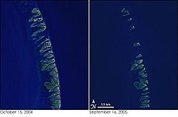
The islands have been generally shrinking and migrating landward since the late 19th century. A survey in the 1980s estimated that they would be in existence for about three more centuries. Before 1996, the seaward front of the islands lost about 20–30 feet of land each year, mostly replaced at the rear. From 1996 to 2004, the loss rate grew to about 300 feet (91.4 m) per year. In 1998, Hurricane Georges
Hurricane Georges
Hurricane Georges was a very destructive, powerful and long-lived Cape Verde-type Category 4 hurricane. Georges was the seventh tropical storm, fourth hurricane, and second major hurricane of the 1998 Atlantic hurricane season...
destroyed the islands and left the lighthouse in the middle of the ocean, and the barrier island
Barrier island
Barrier islands, a coastal landform and a type of barrier system, are relatively narrow strips of sand that parallel the mainland coast. They usually occur in chains, consisting of anything from a few islands to more than a dozen...
s only just recovered when Hurricane Katrina
Hurricane Katrina
Hurricane Katrina of the 2005 Atlantic hurricane season was a powerful Atlantic hurricane. It is the costliest natural disaster, as well as one of the five deadliest hurricanes, in the history of the United States. Among recorded Atlantic hurricanes, it was the sixth strongest overall...
struck in 2005.
However, the combined effect of Hurricane Dennis
Hurricane Dennis
Hurricane Dennis was an early-forming major hurricane in the Caribbean and Gulf of Mexico during the very active 2005 Atlantic hurricane season. Dennis was the fourth named storm, second hurricane, and first major hurricane of the season...
and Hurricane Katrina in 2005 reduced the island to shoals or sub-surface formations, and toppled the Chandeleur Island Light. Powerful storms can produce changes that would otherwise have taken many years. A study released in 2006 by geologist
Geologist
A geologist is a scientist who studies the solid and liquid matter that constitutes the Earth as well as the processes and history that has shaped it. Geologists usually engage in studying geology. Geologists, studying more of an applied science than a theoretical one, must approach Geology using...
s from the University of New Orleans
University of New Orleans
The University of New Orleans, often referred to locally as UNO, is a medium-sized public urban university located on the New Orleans Lakefront within New Orleans, Louisiana, United States. It is a member of the LSU System and the Urban 13 association. Currently UNO is without a proper chancellor...
shows that the usual sand and sediment patterns that rebuilt the islands after big storms have not been restored since Katrina reworked the area. There is also evidence of unprecedented landslides on the seafloor on the side toward the Gulf of Mexico, potentially allowing stronger waves with greater erosional impact to reach the islands. If the islands recover, it may take generations. If movements of sand and sediment do not restore the islands, they may be gone in a decade.
Deepwater Horizon oil spill
The ecosystem on the islands is further threatened by the Deepwater Horizon oil spillDeepwater Horizon oil spill
The Deepwater Horizon oil spill is an oil spill in the Gulf of Mexico which flowed unabated for three months in 2010, and continues to leak fresh oil. It is the largest accidental marine oil spill in the history of the petroleum industry...
in the Gulf of Mexico. On May 6, 2010, the oil sheen reached the islands' shores and the wildlife refuge.