

Hurricane Inez
Encyclopedia
Hurricane Inez was a deadly, destructive, powerful and very long-lived Cape Verde-type hurricane
that carved an erratic path through the Lesser Antilles
, Hispaniola
, Cuba
, the Bahamas
, Florida
, and Mexico
in 1966. Forming unusually far east for late in the season, Inez is among the deadliest hurricanes on record, with an approximate death toll of over 1,000 people across several Caribbean
countries
. In addition to being exceptionally deadly and intense, Inez was the first solitary storm on record to affect the West Indies, Bahamas, Florida
, and Mexico
all on one track; 32 years later, Hurricane Georges
would follow the same track and affect a dozen different countries.
 Inez originated as a weak tropical wave
that moved off the west coast of Africa
on September 18. The disturbance was tracked west-southwestward by satellite, and the cloud mass organized into a tropical depression on September 21 in the central tropical Atlantic. The depression began to move west-northwest on September 23, with little intensification until the afternoon of September 24, when significant development began to occur and the depression was upgraded to Tropical Storm Inez while located 800 miles east of Martinique
. Upon reaching tropical storm
status, a more westward course commenced, and Inez continued to intensify and became a hurricane on September 26. Conditions were favorable for intensification, and Inez rapidly intensified the next day, reaching Category 3 strength while passing through the islands, with the center of the hurricane passing directly over Guadeloupe
, where tropical storm-force winds extended 125 miles from the center as hurricane-force winds extended 60 miles from the center. At the time, intensification temporarily halted due to interaction with mountain
ous Guadeloupe terrain
, with the pressure rising from 960 millibars (28.3 inHg) to 965 millibars (28.5 inHg).
Intensification resumed after passing Guadeloupe
, and Inez rapidly reached its peak of 150 mph while south of Puerto Rico
on September 28. Shortly after peak intensity, Inez struck the Barahona Peninsula of the Dominican Republic
on September 29, weakening to 140 mph while crossing the southwest peninsula of Haiti
. Inez weakened significantly as it crossed the Haitian terrain, weakening to a 90 mph minimal hurricane as it emerged from the northwest coast
of Haiti with a pressure of 987 millibars (29.1 inHg); however, the hurricane rapidly intensified over the Windward Passage
to a major hurricane before striking the southeast Cuba
n coast near Guantanamo Bay on September 30. Inez became disorganized over the rugged terrain, and it quickly weakened to a 75 mph hurricane while slowly paralleling the south coast of Cuba
under weak steering currents over the next 36 hours. In response to a ridge
weakness
, Inez moved inland over central Cuba and moved slowly northward, briefly losing hurricane
intensity before emerging into the southwest Bahamas
on October 2.
 Turning north-northeast, Inez slowly stall
ed and gradually regained intensity over the Bahamas
on October 2 and 3, with winds of 90 mph reported at West End
on Grand Bahama
. A building upper-level anticyclonic ridge from the western Gulf of Mexico
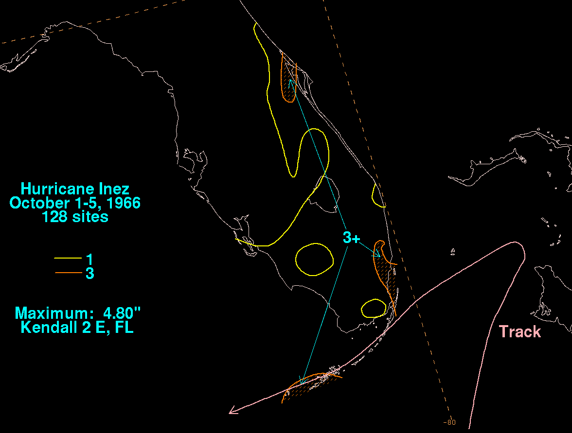
slowly forced Inez to the southwest on October 4, where more conducive upper-level conditions for intensification set in. Inez crossed the Florida Keys
on October 5 as a strengthening hurricane, delivering hurricane-force winds to all of the Keys. Inez moved west-southwest south of the Dry Tortugas
, continuing to intensify to a major hurricane while brushing the Yucatán
on October 7. Inez then began to curve into a weakness in the upper-level ridge over the western Gulf of Mexico
, reaching its peak in the Gulf of Mexico with 140 mph winds and 948 mbar
(hPa
) on October 9. The threat to Texas
increased, but Inez was forced southwest late on October 9 by rising heights to its north, and the storm weakened before making landfall near Tampico
, Mexico
, on October 10. Inez weakened rapidly after landfall, and the storm later dissipated over mainland Mexico the following day.
On Inez's very long track as a powerful major hurricane, passing through the Lesser Antilles, Haiti, Florida, and especially Mexico, killing 651 people.
was the hardest hit by the storm in the Leeward Islands
as it cause extensive damage of the island's infrastructure, where about 30-60% of the homes, businesses were destroyed as the main hospital in Grande-Terre
was severely impacted, this is including roads, power lines and trees that suffered very severe damage. The hurricane devastated also the sugar and banana crops at nearly 100%. President Charles de Gaulle
did not appear on Guadeloupe until two days following the hurricane as he declared the islands a national disaster area
, making it available to aid. However, in the meantime, significant looting, particularly of grocery stores, prevented and orderly distribution of food and water. Inez was directly responsible for about a hundred injured and thirty three deaths, especially in Pointe a Pitre. More than 10.000 people in the 300.000 inhabitants were greatly impact and left homeless here, most buildings sustained some damage and total damage was estimated at $350 million (1966 USD) .
The highest wind speed at landfall left by Inez over Guadeloupe
was 125 mi/h. The storm surge reported was 6.3 feet (1.9 m) over the coast and according to forecaster and historians, The highest storm surge reached 6.5 feet (2 m) to 6.7 feet (2 m) in in Pointe-a-Pitre
harbor and Basse-Terre Island
. Rainfall totals reached about 10 inches in Guadeloupe and nearby islands.
The highest estimated sustained winds were up to 80 mi/h in Raizet
as the highest reported gusts were at least 114 mi/h in a nearby Automated Surface Observing System. The lowest pressure recorded at between 963-964 mbar
(hPa
) in the weather station.
At this time, Inez was far the costliest, the worst and the deadliest hurricane since the 1928
great hurricane, that devastated the same area.
, the name Inez was retired and will never be used for an Atlantic hurricane again; this name was replaced by Isabel in the 1970 season
.
Cape Verde-type hurricane
A Cape Verde-type hurricane is an Atlantic hurricane that develops near the Cape Verde islands, off the west coast of Africa. The average hurricane season has about two Cape Verde-type hurricanes, which are usually the largest and most intense storms of the season because they often have plenty of...
that carved an erratic path through the Lesser Antilles
Lesser Antilles
The Lesser Antilles are a long, partly volcanic island arc in the Western Hemisphere. Most of its islands form the eastern boundary of the Caribbean Sea with the Atlantic Ocean, with the remainder located in the southern Caribbean just north of South America...
, Hispaniola
Hispaniola
Hispaniola is a major island in the Caribbean, containing the two sovereign states of the Dominican Republic and Haiti. The island is located between the islands of Cuba to the west and Puerto Rico to the east, within the hurricane belt...
, Cuba
Cuba
The Republic of Cuba is an island nation in the Caribbean. The nation of Cuba consists of the main island of Cuba, the Isla de la Juventud, and several archipelagos. Havana is the largest city in Cuba and the country's capital. Santiago de Cuba is the second largest city...
, the Bahamas
The Bahamas
The Bahamas , officially the Commonwealth of the Bahamas, is a nation consisting of 29 islands, 661 cays, and 2,387 islets . It is located in the Atlantic Ocean north of Cuba and Hispaniola , northwest of the Turks and Caicos Islands, and southeast of the United States...
, Florida
Florida
Florida is a state in the southeastern United States, located on the nation's Atlantic and Gulf coasts. It is bordered to the west by the Gulf of Mexico, to the north by Alabama and Georgia and to the east by the Atlantic Ocean. With a population of 18,801,310 as measured by the 2010 census, it...
, and Mexico
Mexico
The United Mexican States , commonly known as Mexico , is a federal constitutional republic in North America. It is bordered on the north by the United States; on the south and west by the Pacific Ocean; on the southeast by Guatemala, Belize, and the Caribbean Sea; and on the east by the Gulf of...
in 1966. Forming unusually far east for late in the season, Inez is among the deadliest hurricanes on record, with an approximate death toll of over 1,000 people across several Caribbean
Caribbean
The Caribbean is a crescent-shaped group of islands more than 2,000 miles long separating the Gulf of Mexico and the Caribbean Sea, to the west and south, from the Atlantic Ocean, to the east and north...
countries
Country
A country is a region legally identified as a distinct entity in political geography. A country may be an independent sovereign state or one that is occupied by another state, as a non-sovereign or formerly sovereign political division, or a geographic region associated with a previously...
. In addition to being exceptionally deadly and intense, Inez was the first solitary storm on record to affect the West Indies, Bahamas, Florida
Florida
Florida is a state in the southeastern United States, located on the nation's Atlantic and Gulf coasts. It is bordered to the west by the Gulf of Mexico, to the north by Alabama and Georgia and to the east by the Atlantic Ocean. With a population of 18,801,310 as measured by the 2010 census, it...
, and Mexico
Mexico
The United Mexican States , commonly known as Mexico , is a federal constitutional republic in North America. It is bordered on the north by the United States; on the south and west by the Pacific Ocean; on the southeast by Guatemala, Belize, and the Caribbean Sea; and on the east by the Gulf of...
all on one track; 32 years later, Hurricane Georges
Hurricane Georges
Hurricane Georges was a very destructive, powerful and long-lived Cape Verde-type Category 4 hurricane. Georges was the seventh tropical storm, fourth hurricane, and second major hurricane of the 1998 Atlantic hurricane season...
would follow the same track and affect a dozen different countries.
Meteorological history
Tropical wave
Tropical waves, easterly waves, or tropical easterly waves, also known as African easterly waves in the Atlantic region, are a type of atmospheric trough, an elongated area of relatively low air pressure, oriented north to south, which move from east to west across the tropics causing areas of...
that moved off the west coast of Africa
Africa
Africa is the world's second largest and second most populous continent, after Asia. At about 30.2 million km² including adjacent islands, it covers 6% of the Earth's total surface area and 20.4% of the total land area...
on September 18. The disturbance was tracked west-southwestward by satellite, and the cloud mass organized into a tropical depression on September 21 in the central tropical Atlantic. The depression began to move west-northwest on September 23, with little intensification until the afternoon of September 24, when significant development began to occur and the depression was upgraded to Tropical Storm Inez while located 800 miles east of Martinique
Martinique
Martinique is an island in the eastern Caribbean Sea, with a land area of . Like Guadeloupe, it is an overseas region of France, consisting of a single overseas department. To the northwest lies Dominica, to the south St Lucia, and to the southeast Barbados...
. Upon reaching tropical storm
Tropical cyclone
A tropical cyclone is a storm system characterized by a large low-pressure center and numerous thunderstorms that produce strong winds and heavy rain. Tropical cyclones strengthen when water evaporated from the ocean is released as the saturated air rises, resulting in condensation of water vapor...
status, a more westward course commenced, and Inez continued to intensify and became a hurricane on September 26. Conditions were favorable for intensification, and Inez rapidly intensified the next day, reaching Category 3 strength while passing through the islands, with the center of the hurricane passing directly over Guadeloupe
Guadeloupe
Guadeloupe is an archipelago located in the Leeward Islands, in the Lesser Antilles, with a land area of 1,628 square kilometres and a population of 400,000. It is the first overseas region of France, consisting of a single overseas department. As with the other overseas departments, Guadeloupe...
, where tropical storm-force winds extended 125 miles from the center as hurricane-force winds extended 60 miles from the center. At the time, intensification temporarily halted due to interaction with mountain
Mountain
Image:Himalaya_annotated.jpg|thumb|right|The Himalayan mountain range with Mount Everestrect 58 14 160 49 Chomo Lonzorect 200 28 335 52 Makalurect 378 24 566 45 Mount Everestrect 188 581 920 656 Tibetan Plateaurect 250 406 340 427 Rong River...
ous Guadeloupe terrain
Terrain
Terrain, or land relief, is the vertical and horizontal dimension of land surface. When relief is described underwater, the term bathymetry is used...
, with the pressure rising from 960 millibars (28.3 inHg) to 965 millibars (28.5 inHg).
Intensification resumed after passing Guadeloupe
Guadeloupe
Guadeloupe is an archipelago located in the Leeward Islands, in the Lesser Antilles, with a land area of 1,628 square kilometres and a population of 400,000. It is the first overseas region of France, consisting of a single overseas department. As with the other overseas departments, Guadeloupe...
, and Inez rapidly reached its peak of 150 mph while south of Puerto Rico
Puerto Rico
Puerto Rico , officially the Commonwealth of Puerto Rico , is an unincorporated territory of the United States, located in the northeastern Caribbean, east of the Dominican Republic and west of both the United States Virgin Islands and the British Virgin Islands.Puerto Rico comprises an...
on September 28. Shortly after peak intensity, Inez struck the Barahona Peninsula of the Dominican Republic
Dominican Republic
The Dominican Republic is a nation on the island of La Hispaniola, part of the Greater Antilles archipelago in the Caribbean region. The western third of the island is occupied by the nation of Haiti, making Hispaniola one of two Caribbean islands that are shared by two countries...
on September 29, weakening to 140 mph while crossing the southwest peninsula of Haiti
Haiti
Haiti , officially the Republic of Haiti , is a Caribbean country. It occupies the western, smaller portion of the island of Hispaniola, in the Greater Antillean archipelago, which it shares with the Dominican Republic. Ayiti was the indigenous Taíno or Amerindian name for the island...
. Inez weakened significantly as it crossed the Haitian terrain, weakening to a 90 mph minimal hurricane as it emerged from the northwest coast
Coast
A coastline or seashore is the area where land meets the sea or ocean. A precise line that can be called a coastline cannot be determined due to the dynamic nature of tides. The term "coastal zone" can be used instead, which is a spatial zone where interaction of the sea and land processes occurs...
of Haiti with a pressure of 987 millibars (29.1 inHg); however, the hurricane rapidly intensified over the Windward Passage
Windward Passage
The Windward Passage is a strait in the Caribbean Sea, between the islands of Cuba and Hispaniola. The strait specifically lies between the easternmost region of Cuba and the northwest of Haiti.80km wide, the Windward Passage has a threshold depth of 1,700m...
to a major hurricane before striking the southeast Cuba
Cuba
The Republic of Cuba is an island nation in the Caribbean. The nation of Cuba consists of the main island of Cuba, the Isla de la Juventud, and several archipelagos. Havana is the largest city in Cuba and the country's capital. Santiago de Cuba is the second largest city...
n coast near Guantanamo Bay on September 30. Inez became disorganized over the rugged terrain, and it quickly weakened to a 75 mph hurricane while slowly paralleling the south coast of Cuba
Cuba
The Republic of Cuba is an island nation in the Caribbean. The nation of Cuba consists of the main island of Cuba, the Isla de la Juventud, and several archipelagos. Havana is the largest city in Cuba and the country's capital. Santiago de Cuba is the second largest city...
under weak steering currents over the next 36 hours. In response to a ridge
Ridge (meteorology)
A ridge is an elongated region of relatively high atmospheric pressure, the opposite of a trough....
weakness
Weakness
Weakness is a symptom represented, medically, by a number of different conditions, including: lack of muscle strength, malaise, dizziness, or fatigue. The causes are many and can be divided into conditions that have true or perceived muscle weakness. True muscle weakness is a primary symptom of a...
, Inez moved inland over central Cuba and moved slowly northward, briefly losing hurricane
Saffir-Simpson Hurricane Scale
The Saffir–Simpson Hurricane Scale , or the Saffir–Simpson Hurricane Wind Scale , classifies hurricanes — Western Hemisphere tropical cyclones that exceed the intensities of tropical depressions and tropical storms — into five categories distinguished by the intensities of their sustained winds...
intensity before emerging into the southwest Bahamas
The Bahamas
The Bahamas , officially the Commonwealth of the Bahamas, is a nation consisting of 29 islands, 661 cays, and 2,387 islets . It is located in the Atlantic Ocean north of Cuba and Hispaniola , northwest of the Turks and Caicos Islands, and southeast of the United States...
on October 2.
Stall
In fluid dynamics, a stall is a reduction in the lift coefficient generated by a foil as angle of attack increases. This occurs when the critical angle of attack of the foil is exceeded...
ed and gradually regained intensity over the Bahamas
The Bahamas
The Bahamas , officially the Commonwealth of the Bahamas, is a nation consisting of 29 islands, 661 cays, and 2,387 islets . It is located in the Atlantic Ocean north of Cuba and Hispaniola , northwest of the Turks and Caicos Islands, and southeast of the United States...
on October 2 and 3, with winds of 90 mph reported at West End
West End, Grand Bahama
West End is the oldest town and westernmost settlement on the Bahamian island of Grand Bahama. It is the current capital of Grand Bahama, contrary to the belief that Freeport City is the capital of the island. It is also the third largest settlement in the Bahamas...
on Grand Bahama
Grand Bahama
Grand Bahama is one of the northernmost of the islands of the Bahamas, and the closest major island to the United States, lying off the state of Florida. Grand Bahama is the fifth largest island in the Bahamas island chain of approximately 700 islands and 2,400 cays...
. A building upper-level anticyclonic ridge from the western Gulf of Mexico
Gulf of Mexico
The Gulf of Mexico is a partially landlocked ocean basin largely surrounded by the North American continent and the island of Cuba. It is bounded on the northeast, north and northwest by the Gulf Coast of the United States, on the southwest and south by Mexico, and on the southeast by Cuba. In...
slowly forced Inez to the southwest on October 4, where more conducive upper-level conditions for intensification set in. Inez crossed the Florida Keys
Florida Keys
The Florida Keys are a coral archipelago in southeast United States. They begin at the southeastern tip of the Florida peninsula, about south of Miami, and extend in a gentle arc south-southwest and then westward to Key West, the westernmost of the inhabited islands, and on to the uninhabited Dry...
on October 5 as a strengthening hurricane, delivering hurricane-force winds to all of the Keys. Inez moved west-southwest south of the Dry Tortugas
Dry Tortugas
The Dry Tortugas are a small group of islands, located at the end of the Florida Keys, USA, about west of Key West, and west of the Marquesas Keys, the closest islands. Still further west is the Tortugas Bank, which is completely submerged. The first Europeans to discover the islands were the...
, continuing to intensify to a major hurricane while brushing the Yucatán
Yucatán Peninsula
The Yucatán Peninsula, in southeastern Mexico, separates the Caribbean Sea from the Gulf of Mexico, with the northern coastline on the Yucatán Channel...
on October 7. Inez then began to curve into a weakness in the upper-level ridge over the western Gulf of Mexico
Gulf of Mexico
The Gulf of Mexico is a partially landlocked ocean basin largely surrounded by the North American continent and the island of Cuba. It is bounded on the northeast, north and northwest by the Gulf Coast of the United States, on the southwest and south by Mexico, and on the southeast by Cuba. In...
, reaching its peak in the Gulf of Mexico with 140 mph winds and 948 mbar
Bar (unit)
The bar is a unit of pressure equal to 100 kilopascals, and roughly equal to the atmospheric pressure on Earth at sea level. Other units derived from the bar are the megabar , kilobar , decibar , centibar , and millibar...
(hPa
Pascal (unit)
The pascal is the SI derived unit of pressure, internal pressure, stress, Young's modulus and tensile strength, named after the French mathematician, physicist, inventor, writer, and philosopher Blaise Pascal. It is a measure of force per unit area, defined as one newton per square metre...
) on October 9. The threat to Texas
Texas
Texas is the second largest U.S. state by both area and population, and the largest state by area in the contiguous United States.The name, based on the Caddo word "Tejas" meaning "friends" or "allies", was applied by the Spanish to the Caddo themselves and to the region of their settlement in...
increased, but Inez was forced southwest late on October 9 by rising heights to its north, and the storm weakened before making landfall near Tampico
Tampico
Tampico is a city and port in the state of Tamaulipas, in the country of Mexico. It is located in the southeastern part of the state, directly north across the border from Veracruz. Tampico is the third largest city in Tamaulipas, and counts with a population of 309,003. The Metropolitan area of...
, Mexico
Mexico
The United Mexican States , commonly known as Mexico , is a federal constitutional republic in North America. It is bordered on the north by the United States; on the south and west by the Pacific Ocean; on the southeast by Guatemala, Belize, and the Caribbean Sea; and on the east by the Gulf of...
, on October 10. Inez weakened rapidly after landfall, and the storm later dissipated over mainland Mexico the following day.
Impact
| Country | Fatalities | Damage (USD) |
| Bahamas | 5 | $15.5 million |
| Cuba Cuba The Republic of Cuba is an island nation in the Caribbean. The nation of Cuba consists of the main island of Cuba, the Isla de la Juventud, and several archipelagos. Havana is the largest city in Cuba and the country's capital. Santiago de Cuba is the second largest city... |
5 | $18 million |
| Dominican Republic Dominican Republic The Dominican Republic is a nation on the island of La Hispaniola, part of the Greater Antilles archipelago in the Caribbean region. The western third of the island is occupied by the nation of Haiti, making Hispaniola one of two Caribbean islands that are shared by two countries... |
74 | $5 million |
| Guadeloupe Guadeloupe Guadeloupe is an archipelago located in the Leeward Islands, in the Lesser Antilles, with a land area of 1,628 square kilometres and a population of 400,000. It is the first overseas region of France, consisting of a single overseas department. As with the other overseas departments, Guadeloupe... |
33 | $350 million |
| Haiti Haiti Haiti , officially the Republic of Haiti , is a Caribbean country. It occupies the western, smaller portion of the island of Hispaniola, in the Greater Antillean archipelago, which it shares with the Dominican Republic. Ayiti was the indigenous Taíno or Amerindian name for the island... |
480 | $20 million |
| Mexico Mexico The United Mexican States , commonly known as Mexico , is a federal constitutional republic in North America. It is bordered on the north by the United States; on the south and west by the Pacific Ocean; on the southeast by Guatemala, Belize, and the Caribbean Sea; and on the east by the Gulf of... |
1,000 | $24 million |
| United States United States The United States of America is a federal constitutional republic comprising fifty states and a federal district... |
48 | Unknown |
| Total | 1,637 | $432.5 million |
On Inez's very long track as a powerful major hurricane, passing through the Lesser Antilles, Haiti, Florida, and especially Mexico, killing 651 people.
Guadeloupe
The island of GuadeloupeGuadeloupe
Guadeloupe is an archipelago located in the Leeward Islands, in the Lesser Antilles, with a land area of 1,628 square kilometres and a population of 400,000. It is the first overseas region of France, consisting of a single overseas department. As with the other overseas departments, Guadeloupe...
was the hardest hit by the storm in the Leeward Islands
Leeward Islands
The Leeward Islands are a group of islands in the West Indies. They are the northern islands of the Lesser Antilles chain. As a group they start east of Puerto Rico and reach southward to Dominica. They are situated where the northeastern Caribbean Sea meets the western Atlantic Ocean...
as it cause extensive damage of the island's infrastructure, where about 30-60% of the homes, businesses were destroyed as the main hospital in Grande-Terre
Grande-Terre
Grande-Terre is an island in the Guadeloupe, separated by Basse-Terre Island by a salt river. Grande-Terre's northernmost point, Pointe de la Grande Vigie, is also the northernmost point in Guadeloupe....
was severely impacted, this is including roads, power lines and trees that suffered very severe damage. The hurricane devastated also the sugar and banana crops at nearly 100%. President Charles de Gaulle
Charles de Gaulle
Charles André Joseph Marie de Gaulle was a French general and statesman who led the Free French Forces during World War II. He later founded the French Fifth Republic in 1958 and served as its first President from 1959 to 1969....
did not appear on Guadeloupe until two days following the hurricane as he declared the islands a national disaster area
Disaster area
A disaster area is a region or a locale heavily damaged by either natural hazards, such as tornadoes, hurricanes, tsunamis, floods, earthquakes, technological hazards including nuclear and radiation accidents, or sociological hazards like riots, terrorism or war. The population living there often...
, making it available to aid. However, in the meantime, significant looting, particularly of grocery stores, prevented and orderly distribution of food and water. Inez was directly responsible for about a hundred injured and thirty three deaths, especially in Pointe a Pitre. More than 10.000 people in the 300.000 inhabitants were greatly impact and left homeless here, most buildings sustained some damage and total damage was estimated at $350 million (1966 USD) .
The highest wind speed at landfall left by Inez over Guadeloupe
Guadeloupe
Guadeloupe is an archipelago located in the Leeward Islands, in the Lesser Antilles, with a land area of 1,628 square kilometres and a population of 400,000. It is the first overseas region of France, consisting of a single overseas department. As with the other overseas departments, Guadeloupe...
was 125 mi/h. The storm surge reported was 6.3 feet (1.9 m) over the coast and according to forecaster and historians, The highest storm surge reached 6.5 feet (2 m) to 6.7 feet (2 m) in in Pointe-a-Pitre
Pointe-à-Pitre
Pointe-à-Pitre is the largest city of Guadeloupe, an overseas région and département of France located in the Lesser Antilles, of which it is a sous-préfecture, being the seat of the Arrondissement of Pointe-à-Pitre....
harbor and Basse-Terre Island
Basse-Terre Island
Basse-Terre Island is the name of the western-half of Guadeloupe proper, in the Lesser Antilles. It is separated from the other half of Guadeloupe proper, Grande-Terre, by a narrow sea channel called the Rivière Salée ....
. Rainfall totals reached about 10 inches in Guadeloupe and nearby islands.
The highest estimated sustained winds were up to 80 mi/h in Raizet
Pointe-à-Pitre International Airport
Pointe-à-Pitre International Airport or Pointe-à-Pitre Le Raizet Airport is an airport serving Pointe-à-Pitre on the island of Grande-Terre in Guadeloupe. The airport is located in Abymes, north-northeast of Pointe-à-Pitre. It is the main hub for Air Caraïbes and Air Antilles Express. It is the...
as the highest reported gusts were at least 114 mi/h in a nearby Automated Surface Observing System. The lowest pressure recorded at between 963-964 mbar
Bar (unit)
The bar is a unit of pressure equal to 100 kilopascals, and roughly equal to the atmospheric pressure on Earth at sea level. Other units derived from the bar are the megabar , kilobar , decibar , centibar , and millibar...
(hPa
Pascal (unit)
The pascal is the SI derived unit of pressure, internal pressure, stress, Young's modulus and tensile strength, named after the French mathematician, physicist, inventor, writer, and philosopher Blaise Pascal. It is a measure of force per unit area, defined as one newton per square metre...
) in the weather station.
At this time, Inez was far the costliest, the worst and the deadliest hurricane since the 1928
1928 Okeechobee Hurricane
The Okeechobee hurricane, or San Felipe Segundo hurricane, was a deadly hurricane that struck the Leeward Islands, Puerto Rico, the Bahamas, and Florida in September of the 1928 Atlantic hurricane season...
great hurricane, that devastated the same area.
Greater Antilles and Bahamas
According to the Monthly Weather Review report, Haiti fared the worst. More than 1,000 people perished in Haiti and 200 more in the Dominican Republic along with $12 million in damage. Cuba fared considerably better, with only 5 deaths despite $20 million in damage. Throughout the Bahamas, Inez killed five people and left roughly $15.5 million in damage.Retirement
Due to the extensive damage and extreme deaths in the CaribbeanCaribbean
The Caribbean is a crescent-shaped group of islands more than 2,000 miles long separating the Gulf of Mexico and the Caribbean Sea, to the west and south, from the Atlantic Ocean, to the east and north...
, the name Inez was retired and will never be used for an Atlantic hurricane again; this name was replaced by Isabel in the 1970 season
1970 Atlantic hurricane season
The 1970 Atlantic hurricane season officially began on June 1, 1970, and lasted until November 30, 1970. These dates conventionally delimit the period of each year when most tropical cyclones form in the Atlantic basin...
.
See also
- List of Atlantic hurricanes
- List of retired Atlantic hurricane names
- List of Florida hurricanes