
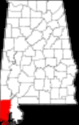
Mobile County, Alabama
Encyclopedia
Mobile County[p] is a county
of the U.S. state
of Alabama
. Its name is in honor of a tribe of Indians
, the Maubila
tribe (see Mobilian
). As of 2011, its population was 415,704. Its county seat
is Mobile, Alabama
. The entire county is included in the Mobile metropolitan statistical area.
were among the Native Americans encountered by early French
traders and colonists, who founded Mobile
in the early eighteenth century. The British took over the territory in 1763 after defeating the French in the Seven Years War. During the American Revolutionary War
, it came under Spanish rule as part of Spanish Florida
. It was ceded to the United States after the War of 1812
.
Most of the Native Americans in the area were removed
in the 1830s under President Andrew Jackson
's policy to relocate them to Indian Territory
west of the Mississippi River. The MOWA Band of Choctaw Indians
was recognized as a tribe in 1979 by the state; it occupies land along the border of Mobile and Washington counties.
Mobile County was created by European Americans by a proclamation of Governor Holmes of the Mississippi Territory
on December 18, 1812.
The area became part of the Alabama Territory
on August 15, 1817, on the day that Mississippi became a state. Two years later, the county became part of the Alabama, when granted statehood
on December 14, 1819.
The city of Mobile, first settled by French colonists as part of La Louisiane, has always been designated as the county seat. Both the county and city derive their name from Fort Louis de la Mobile, a French fortification established (near present-day Axis, Alabama
) in 1702. The word "Mobile" is believed to stem from a Choctaw
Indian word for "paddlers". The area was occupied by French colonists from 1702–1763, by the British from 1763–1780, and by the Spanish from 1780-1813. Courthouse fires occurred in the years 1823, 1840, and 1872.
Current (as of June 2009) Mobile County Commissioners are:
by three senators
and nine representatives
. It is represented in the Alabama Senate
by Democrat
Vivian Davis Figures
from the 33rd district, by Republican Rusty Glover
from the 34th district, and by Republican Ben Brooks
from the 35th district. It is represented in the Alabama House of Representatives
by Democrat Yvonne Kennedy from the 97th district, Democrat Napoleon Bracy from the 98th district, Democrat James Buskey from the 99th district, Republican Victor Gaston from the 100th district, Republican Jamie Ison from the 101st district, Republican Chad Fincher from the 102nd district, Democrat Joseph C. Mitchell from the 103rd district, Republican Jim Barton from the 104th district, and Republican David Sessions
from the 105th district.
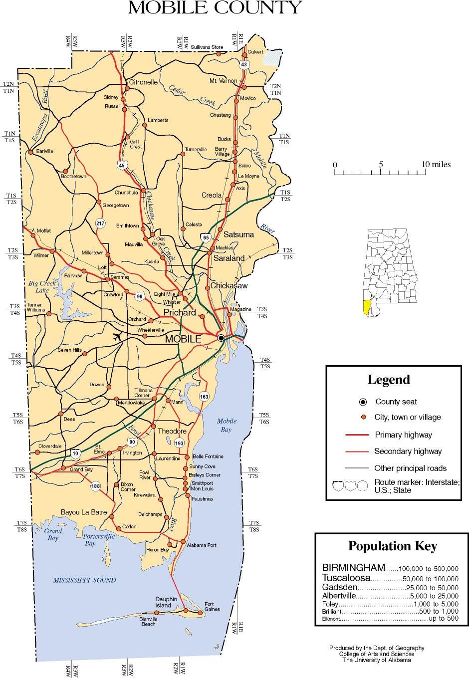
 According to the 2000 census, the county has a total area of 1644.02 square miles (4,258 km²), of which 1233.09 square miles (3,193.7 km²) (or 75.00%) is land and 410.93 square miles (1,064.3 km²) (or 25.00%) is water. It includes several islands, including Dauphin Island, Gaillard Island
and Mon Louis Island
.
of 2000, there were 399,843 people, 150,179 households, and 106,777 families residing in the county. The population density
was 324 people per square mile (125/km2). There were 165,101 housing units at an average density of 134 per square mile (52/km2). The racial makeup of the county was 63.07% White
, 33.38% Black
or African American
, 0.67% Native American
, 1.41% Asian
, 0.03% Pacific Islander
, 0.40% from other races
, and 1.04% from two or more races. 1.22% of the population were Hispanic
or Latino
of any race.
There were 150,179 households out of which 34.40% had children under the age of 18 living with them, 49.50% were married couples
living together, 17.70% had a female householder with no husband present, and 28.90% were non-families. 24.80% of all households were made up of individuals and 8.80% had someone living alone who was 65 years of age or older. The average household size was 2.61 and the average family size was 3.13.
In the county the population dispersal was 27.50% under the age of 18, 10.00% from 18 to 24, 28.70% from 25 to 44, 21.90% from 45 to 64, and 12.00% who were 65 years of age or older. The median age was 34 years. For every 100 females there were 91.50 males. For every 100 females age 18 and over, there were 87.10 males. The median income for a household in the county was $33,710, and the median income for a family was $40,378. Males had a median income of $32,329 versus $21,986 for females. The per capita income
for the county was $17,178. About 15.60% of families and 18.50% of the population were below the poverty line, including 26.20% of those under age 18 and 14.60% of those age 65 or over.
presidential candidate won 59% of the vote and 92,014 votes. Democrat John F. Kerry won 40% of the vote and 63,732 votes. Other candidates won 1% of the vote.
In the 2008 presidential election, Mobile County again cast the majority of its votes for the Republican
candidate; this was John McCain
. He won 54% of the vote and 98,049 votes. Democrat
Barack Obama
received 45% of the vote and 82,181 votes. Other candidates won 1% of the vote.
In the Senate election in 2008, Republican Jeff Sessions did better than John McCain. Sessions won 57% of the vote and 102,043 votes. His challenger, Democrat Vivian D. Figures, won 43% of the vote and 77,292 votes.
.
County (United States)
In the United States, a county is a geographic subdivision of a state , usually assigned some governmental authority. The term "county" is used in 48 of the 50 states; Louisiana is divided into parishes and Alaska into boroughs. Parishes and boroughs are called "county-equivalents" by the U.S...
of the U.S. state
U.S. state
A U.S. state is any one of the 50 federated states of the United States of America that share sovereignty with the federal government. Because of this shared sovereignty, an American is a citizen both of the federal entity and of his or her state of domicile. Four states use the official title of...
of Alabama
Alabama
Alabama is a state located in the southeastern region of the United States. It is bordered by Tennessee to the north, Georgia to the east, Florida and the Gulf of Mexico to the south, and Mississippi to the west. Alabama ranks 30th in total land area and ranks second in the size of its inland...
. Its name is in honor of a tribe of Indians
Native Americans in the United States
Native Americans in the United States are the indigenous peoples in North America within the boundaries of the present-day continental United States, parts of Alaska, and the island state of Hawaii. They are composed of numerous, distinct tribes, states, and ethnic groups, many of which survive as...
, the Maubila
Mauvilla
-Places:* the word "Mauvilla" which became: Mavilla, Mauvila, Maubila. By 1693, the name had become fairly standardized as "Mobila" or "Movila"....
tribe (see Mobilian
Mobilian
Mobilian may refer to:*Mobilian jargon - An informal Native Americans trade language used among the tribes of the Southeastern United States, primarily along the coast of the Gulf of Mexico*The Native American village of Mabila...
). As of 2011, its population was 415,704. Its county seat
County seat
A county seat is an administrative center, or seat of government, for a county or civil parish. The term is primarily used in the United States....
is Mobile, Alabama
Mobile, Alabama
Mobile is the third most populous city in the Southern US state of Alabama and is the county seat of Mobile County. It is located on the Mobile River and the central Gulf Coast of the United States. The population within the city limits was 195,111 during the 2010 census. It is the largest...
. The entire county is included in the Mobile metropolitan statistical area.
History
This area was occupied for thousands of years by varying cultures of indigenous peoples. The historic ChoctawChoctaw
The Choctaw are a Native American people originally from the Southeastern United States...
were among the Native Americans encountered by early French
France
The French Republic , The French Republic , The French Republic , (commonly known as France , is a unitary semi-presidential republic in Western Europe with several overseas territories and islands located on other continents and in the Indian, Pacific, and Atlantic oceans. Metropolitan France...
traders and colonists, who founded Mobile
Mobile, Alabama
Mobile is the third most populous city in the Southern US state of Alabama and is the county seat of Mobile County. It is located on the Mobile River and the central Gulf Coast of the United States. The population within the city limits was 195,111 during the 2010 census. It is the largest...
in the early eighteenth century. The British took over the territory in 1763 after defeating the French in the Seven Years War. During the American Revolutionary War
American Revolutionary War
The American Revolutionary War , the American War of Independence, or simply the Revolutionary War, began as a war between the Kingdom of Great Britain and thirteen British colonies in North America, and ended in a global war between several European great powers.The war was the result of the...
, it came under Spanish rule as part of Spanish Florida
Spanish Florida
Spanish Florida refers to the Spanish territory of Florida, which formed part of the Captaincy General of Cuba, the Viceroyalty of New Spain, and the Spanish Empire. Originally extending over what is now the southeastern United States, but with no defined boundaries, la Florida was a component of...
. It was ceded to the United States after the War of 1812
War of 1812
The War of 1812 was a military conflict fought between the forces of the United States of America and those of the British Empire. The Americans declared war in 1812 for several reasons, including trade restrictions because of Britain's ongoing war with France, impressment of American merchant...
.
Most of the Native Americans in the area were removed
Indian Removal
Indian removal was a nineteenth century policy of the government of the United States to relocate Native American tribes living east of the Mississippi River to lands west of the river...
in the 1830s under President Andrew Jackson
Andrew Jackson
Andrew Jackson was the seventh President of the United States . Based in frontier Tennessee, Jackson was a politician and army general who defeated the Creek Indians at the Battle of Horseshoe Bend , and the British at the Battle of New Orleans...
's policy to relocate them to Indian Territory
Indian Territory
The Indian Territory, also known as the Indian Territories and the Indian Country, was land set aside within the United States for the settlement of American Indians...
west of the Mississippi River. The MOWA Band of Choctaw Indians
MOWA Band of Choctaw Indians
The MOWA Band of Choctaw Indians are a state-recognized Native American tribe located in southern Alabama, primarily in Washington and Mobile counties. The MOWA Choctaw Reservation is located along the banks of the Mobile and Tombigbee rivers, on 300 acres near the small southwestern Alabama...
was recognized as a tribe in 1979 by the state; it occupies land along the border of Mobile and Washington counties.
Mobile County was created by European Americans by a proclamation of Governor Holmes of the Mississippi Territory
Mississippi Territory
The Territory of Mississippi was an organized incorporated territory of the United States that existed from April 7, 1798, until December 10, 1817, when the final extent of the territory was admitted to the Union as the state of Mississippi....
on December 18, 1812.
The area became part of the Alabama Territory
Alabama Territory
The Territory of Alabama was an organized incorporated territory of the United States that existed from August 15, 1817, until December 14, 1819, when it was admitted to the Union as the State of Alabama.-History:...
on August 15, 1817, on the day that Mississippi became a state. Two years later, the county became part of the Alabama, when granted statehood
U.S. state
A U.S. state is any one of the 50 federated states of the United States of America that share sovereignty with the federal government. Because of this shared sovereignty, an American is a citizen both of the federal entity and of his or her state of domicile. Four states use the official title of...
on December 14, 1819.
The city of Mobile, first settled by French colonists as part of La Louisiane, has always been designated as the county seat. Both the county and city derive their name from Fort Louis de la Mobile, a French fortification established (near present-day Axis, Alabama
Axis, Alabama
Axis is an unincorporated community and census-designated place in Mobile County, Alabama. It has a post office with the 36505 ZIP code. The community has one site listed on the Alabama Register of Landmarks and Heritage, the Kirk House.-Demographics:...
) in 1702. The word "Mobile" is believed to stem from a Choctaw
Choctaw
The Choctaw are a Native American people originally from the Southeastern United States...
Indian word for "paddlers". The area was occupied by French colonists from 1702–1763, by the British from 1763–1780, and by the Spanish from 1780-1813. Courthouse fires occurred in the years 1823, 1840, and 1872.
Local
Mobile County is governed by a three-member county commission. Each commissioner represents a district and is elected by the voters of that district to serve a four-year term. Each commissioner has an equal vote on the commission. One of the commissioners is selected as Commission President.Current (as of June 2009) Mobile County Commissioners are:
- District 1 (northern County) – Merceria L. Ludgood (D) (current Commission President)
- District 2 (western and central County) – Connie Hudson (R)
- District 3 (southern County) – Mike Dean (R)
State
Mobile County is represented in the Alabama LegislatureAlabama Legislature
The Alabama Legislature is the legislative branch of the state government of Alabama. It is a bicameral body composed of the Alabama House of Representatives, with 105 members, and the Alabama Senate, with 35 members...
by three senators
Alabama Senate
The Alabama State Senate is the upper house of the Alabama Legislature, the state legislature of the U.S. state of Alabama. The body is composed of 35 members representing an equal amount of districts across the state, with each district containing at least 127,140 citizens...
and nine representatives
Alabama House of Representatives
The Alabama House of Representatives is the lower house of the Alabama Legislature, the state legislature of the U.S. state of Alabama. The House is composed of 105 members representing an equal amount of districts, with each constituency containing at least 42,380 citizens. There are no term...
. It is represented in the Alabama Senate
Alabama Senate
The Alabama State Senate is the upper house of the Alabama Legislature, the state legislature of the U.S. state of Alabama. The body is composed of 35 members representing an equal amount of districts across the state, with each district containing at least 127,140 citizens...
by Democrat
Democratic Party (United States)
The Democratic Party is one of two major contemporary political parties in the United States, along with the Republican Party. The party's socially liberal and progressive platform is largely considered center-left in the U.S. political spectrum. The party has the lengthiest record of continuous...
Vivian Davis Figures
Vivian Davis Figures
Vivian Davis Figures is a Democratic member of the Alabama Senate, representing the 33rd District in Mobile County since she was elected on January 28, 1997 to serve the remaining term of her late husband, Senator Michael A. Figures, who was the President Pro Tempore of the Senate...
from the 33rd district, by Republican Rusty Glover
Rusty Glover
Rusty Glover is a Republican member of the Alabama Senate, representing the 34th District since 2007. Previously he was a member of the Alabama House of Representatives representing the 102nd District from 2003 through 2006.- Biography :...
from the 34th district, and by Republican Ben Brooks
Ben Brooks
Ben Brooks is a Republican member of the Alabama Senate, representing the 35th District since 2007.-External links:* official government website* profile*Follow the Money - Ben Brooks** campaign contributions...
from the 35th district. It is represented in the Alabama House of Representatives
Alabama House of Representatives
The Alabama House of Representatives is the lower house of the Alabama Legislature, the state legislature of the U.S. state of Alabama. The House is composed of 105 members representing an equal amount of districts, with each constituency containing at least 42,380 citizens. There are no term...
by Democrat Yvonne Kennedy from the 97th district, Democrat Napoleon Bracy from the 98th district, Democrat James Buskey from the 99th district, Republican Victor Gaston from the 100th district, Republican Jamie Ison from the 101st district, Republican Chad Fincher from the 102nd district, Democrat Joseph C. Mitchell from the 103rd district, Republican Jim Barton from the 104th district, and Republican David Sessions
David Sessions
David Sessions is a Republican Party member of the Alabama House of Representatives from House District 105. Sessions was elected to office on May 10, 2011 in a special election held to fill the legislative seat left vacant by the appointment of Spencer Collier to the Alabama Department of...
from the 105th district.
Geography
Gaillard Island
Gaillard Island is a dredge disposal island located in Mobile Bay near Mobile, Alabama. The island is an important site for colonial nesting seabirds and shore birds in coastal Alabama and has been the only nesting site for brown pelicans in Alabama - first discovered in 1983.-Geography:The...
and Mon Louis Island
Mon Louis Island
Mon Louis Island, originally known as Isle aux Maraguans, is an island on the coast of the U.S. state of Alabama, south of Mobile. Located in southeastern Mobile County, it has an average elevation of . Roughly wide and long, it is bounded by Fowl River on the north and west, Mobile Bay on the...
.
Major highways
.svg.png) Interstate 10Interstate 10Interstate 10 is the fourth-longest Interstate Highway in the United States, after I-90, I-80, and I-40. It is the southernmost east–west, coast-to-coast Interstate Highway, although I-4 and I-8 are further south. It stretches from the Pacific Ocean at State Route 1 in Santa Monica,...
Interstate 10Interstate 10Interstate 10 is the fourth-longest Interstate Highway in the United States, after I-90, I-80, and I-40. It is the southernmost east–west, coast-to-coast Interstate Highway, although I-4 and I-8 are further south. It stretches from the Pacific Ocean at State Route 1 in Santa Monica,....svg.png) Interstate 65Interstate 65Interstate 65 is a major Interstate Highway in the United States. The southern terminus is located at an intersection with Interstate 10 in Mobile, Alabama, and its northern terminus is at an interchange with Interstate 90 , U.S. Route 12, and U.S...
Interstate 65Interstate 65Interstate 65 is a major Interstate Highway in the United States. The southern terminus is located at an intersection with Interstate 10 in Mobile, Alabama, and its northern terminus is at an interchange with Interstate 90 , U.S. Route 12, and U.S....svg.png) Interstate 165Interstate 165Interstate 165 is a spur from Interstate 65 that provides access to Mobile, Alabama. It runs for 4.9 miles from Beauregard Street in downtown Mobile north to Interstate 65 in Prichard. As it is, I-165 terminates into Water Street which itself terminates into an I-10 on-ramp less than two miles ...
Interstate 165Interstate 165Interstate 165 is a spur from Interstate 65 that provides access to Mobile, Alabama. It runs for 4.9 miles from Beauregard Street in downtown Mobile north to Interstate 65 in Prichard. As it is, I-165 terminates into Water Street which itself terminates into an I-10 on-ramp less than two miles ... planned western bypass
 U.S. Highway 43
 U.S. Highway 45
 U.S. Highway 90
 U.S. Highway 98
Adjacent counties
- Washington CountyWashington County, AlabamaWashington County is a county of the U.S. state of Alabama. The county was named in honor of George Washington, first President of the United States of America. As of 2010, the population was 17,581. Its county seat is Chatom. Washington County is a dry county.-History:The area was long inhabited...
(north) - Baldwin CountyBaldwin County, Alabama-2010:Whereas according to the 2010 U.S. Census Bureau:*85.7% White*9.4% Black*0.7% Native American*0.7% Asian*0.0% Native Hawaiian or Pacific Islander*1.5% Two or more races*4.4% Hispanic or Latino -2000:...
(east) - Jackson County, MississippiJackson County, MississippiThere were 47,676 households out of which 37.00% had children under the age of 18 living with them, 55.70% were married couples living together, 14.50% had a female householder with no husband present, and 25.10% were non-families. 20.80% of all households were made up of individuals and 7.10% had...
(southwest) - George County, MississippiGeorge County, Mississippi-Demographics:As of the census of 2000, there were 19,144 people, 6,742 households, and 5,305 families residing in the county. The population density was 40 people per square mile . There were 7,513 housing units at an average density of 16 per square mile...
(west) - Greene County, MississippiGreene County, Mississippi-Demographics:As of the census of 2000, there were 13,299 people, 4,148 households, and 3,152 families residing in the county. The population density was 19 people per square mile . There were 4,947 housing units at an average density of 7 per square mile...
(northwest)
National protected areas
- Bon Secour National Wildlife RefugeBon Secour National Wildlife RefugeBon Secour National Wildlife Refuge is a National Wildlife Refuge located in five separate units in Baldwin and Mobile Counties, directly west of Gulf Shores, Alabama on the Fort Morgan peninsula. The refuge serves as a resting and feeding area for migratory birds and as a sanctuary for native...
(part) - Grand Bay National Wildlife RefugeGrand Bay National Wildlife RefugeGrand Bay National Wildlife Refuge was established in 1992 under the Emergency Wetlands Resources Act of 1986 to protect one of the largest expanses of undisturbed pine savanna habitats in the Gulf Coastal Plain region. The refuge is located near Grand Bay, Alabama in Mobile County, Alabama and...
(part)
Demographics
2010
Whereas according to the 2010 U.S. Census Bureau:- 60.2% WhiteWhite AmericanWhite Americans are people of the United States who are considered or consider themselves White. The United States Census Bureau defines White people as those "having origins in any of the original peoples of Europe, the Middle East, or North Africa...
- 34.6% BlackAfrican AmericanAfrican Americans are citizens or residents of the United States who have at least partial ancestry from any of the native populations of Sub-Saharan Africa and are the direct descendants of enslaved Africans within the boundaries of the present United States...
- 0.9% Native AmericanNative Americans in the United StatesNative Americans in the United States are the indigenous peoples in North America within the boundaries of the present-day continental United States, parts of Alaska, and the island state of Hawaii. They are composed of numerous, distinct tribes, states, and ethnic groups, many of which survive as...
- 1.8% AsianAsian AmericanAsian Americans are Americans of Asian descent. The U.S. Census Bureau definition of Asians as "Asian” refers to a person having origins in any of the original peoples of the Far East, Southeast Asia, or the Indian subcontinent, including, for example, Cambodia, China, India, Indonesia, Japan,...
- 0.0% Native Hawaiian or Pacific IslanderPacific Islander AmericanPacific Islander Americans, also known as Oceanian Americans, are residents of the United States with original ancestry from Oceania. They represent the smallest racial group counted in the United States census of 2000. They numbered 874,000 people or 0.3 percent of the United States population...
- 1.5% Two or more racesMultiracial AmericanMultiracial Americans, US residents who identify themselves as of "two or more races", were numbered at around 9 million, or 2.9% of the population, in the census of 2010. However there is considerable evidence that the real number is far higher. Prior to the mid-20th century many people hid their...
- 2.4% Hispanic or LatinoHispanic and Latino AmericansHispanic or Latino Americans are Americans with origins in the Hispanic countries of Latin America or in Spain, and in general all persons in the United States who self-identify as Hispanic or Latino.1990 Census of Population and Housing: A self-designated classification for people whose origins...
(of any race)
2000
As of the censusCensus
A census is the procedure of systematically acquiring and recording information about the members of a given population. It is a regularly occurring and official count of a particular population. The term is used mostly in connection with national population and housing censuses; other common...
of 2000, there were 399,843 people, 150,179 households, and 106,777 families residing in the county. The population density
Population density
Population density is a measurement of population per unit area or unit volume. It is frequently applied to living organisms, and particularly to humans...
was 324 people per square mile (125/km2). There were 165,101 housing units at an average density of 134 per square mile (52/km2). The racial makeup of the county was 63.07% White
Race (United States Census)
Race and ethnicity in the United States Census, as defined by the Federal Office of Management and Budget and the United States Census Bureau, are self-identification data items in which residents choose the race or races with which they most closely identify, and indicate whether or not they are...
, 33.38% Black
Race (United States Census)
Race and ethnicity in the United States Census, as defined by the Federal Office of Management and Budget and the United States Census Bureau, are self-identification data items in which residents choose the race or races with which they most closely identify, and indicate whether or not they are...
or African American
Race (United States Census)
Race and ethnicity in the United States Census, as defined by the Federal Office of Management and Budget and the United States Census Bureau, are self-identification data items in which residents choose the race or races with which they most closely identify, and indicate whether or not they are...
, 0.67% Native American
Race (United States Census)
Race and ethnicity in the United States Census, as defined by the Federal Office of Management and Budget and the United States Census Bureau, are self-identification data items in which residents choose the race or races with which they most closely identify, and indicate whether or not they are...
, 1.41% Asian
Race (United States Census)
Race and ethnicity in the United States Census, as defined by the Federal Office of Management and Budget and the United States Census Bureau, are self-identification data items in which residents choose the race or races with which they most closely identify, and indicate whether or not they are...
, 0.03% Pacific Islander
Race (United States Census)
Race and ethnicity in the United States Census, as defined by the Federal Office of Management and Budget and the United States Census Bureau, are self-identification data items in which residents choose the race or races with which they most closely identify, and indicate whether or not they are...
, 0.40% from other races
Race (United States Census)
Race and ethnicity in the United States Census, as defined by the Federal Office of Management and Budget and the United States Census Bureau, are self-identification data items in which residents choose the race or races with which they most closely identify, and indicate whether or not they are...
, and 1.04% from two or more races. 1.22% of the population were Hispanic
Race (United States Census)
Race and ethnicity in the United States Census, as defined by the Federal Office of Management and Budget and the United States Census Bureau, are self-identification data items in which residents choose the race or races with which they most closely identify, and indicate whether or not they are...
or Latino
Race (United States Census)
Race and ethnicity in the United States Census, as defined by the Federal Office of Management and Budget and the United States Census Bureau, are self-identification data items in which residents choose the race or races with which they most closely identify, and indicate whether or not they are...
of any race.
There were 150,179 households out of which 34.40% had children under the age of 18 living with them, 49.50% were married couples
Marriage
Marriage is a social union or legal contract between people that creates kinship. It is an institution in which interpersonal relationships, usually intimate and sexual, are acknowledged in a variety of ways, depending on the culture or subculture in which it is found...
living together, 17.70% had a female householder with no husband present, and 28.90% were non-families. 24.80% of all households were made up of individuals and 8.80% had someone living alone who was 65 years of age or older. The average household size was 2.61 and the average family size was 3.13.
In the county the population dispersal was 27.50% under the age of 18, 10.00% from 18 to 24, 28.70% from 25 to 44, 21.90% from 45 to 64, and 12.00% who were 65 years of age or older. The median age was 34 years. For every 100 females there were 91.50 males. For every 100 females age 18 and over, there were 87.10 males. The median income for a household in the county was $33,710, and the median income for a family was $40,378. Males had a median income of $32,329 versus $21,986 for females. The per capita income
Per capita income
Per capita income or income per person is a measure of mean income within an economic aggregate, such as a country or city. It is calculated by taking a measure of all sources of income in the aggregate and dividing it by the total population...
for the county was $17,178. About 15.60% of families and 18.50% of the population were below the poverty line, including 26.20% of those under age 18 and 14.60% of those age 65 or over.
2004 and 2008 election results
In 2004, the Republican George W. BushGeorge W. Bush
George Walker Bush is an American politician who served as the 43rd President of the United States, from 2001 to 2009. Before that, he was the 46th Governor of Texas, having served from 1995 to 2000....
presidential candidate won 59% of the vote and 92,014 votes. Democrat John F. Kerry won 40% of the vote and 63,732 votes. Other candidates won 1% of the vote.
In the 2008 presidential election, Mobile County again cast the majority of its votes for the Republican
Republican Party (United States)
The Republican Party is one of the two major contemporary political parties in the United States, along with the Democratic Party. Founded by anti-slavery expansion activists in 1854, it is often called the GOP . The party's platform generally reflects American conservatism in the U.S...
candidate; this was John McCain
John McCain
John Sidney McCain III is the senior United States Senator from Arizona. He was the Republican nominee for president in the 2008 United States election....
. He won 54% of the vote and 98,049 votes. Democrat
Democratic Party (United States)
The Democratic Party is one of two major contemporary political parties in the United States, along with the Republican Party. The party's socially liberal and progressive platform is largely considered center-left in the U.S. political spectrum. The party has the lengthiest record of continuous...
Barack Obama
Barack Obama
Barack Hussein Obama II is the 44th and current President of the United States. He is the first African American to hold the office. Obama previously served as a United States Senator from Illinois, from January 2005 until he resigned following his victory in the 2008 presidential election.Born in...
received 45% of the vote and 82,181 votes. Other candidates won 1% of the vote.
In the Senate election in 2008, Republican Jeff Sessions did better than John McCain. Sessions won 57% of the vote and 102,043 votes. His challenger, Democrat Vivian D. Figures, won 43% of the vote and 77,292 votes.
Census-designated places
- Grand BayGrand Bay, AlabamaGrand Bay is a census-designated place in Mobile County, Alabama, United States. It is included in the Mobile metropolitan statistical area. The population was 3,918 at the 2000 census.-Geography:...
- TheodoreTheodore, AlabamaTheodore is a census-designated place in Mobile County, Alabama, United States. The population was 6,811 at the 2000 census. It is a part of the Mobile metropolitan statistical area...
- Tillmans CornerTillmans Corner, AlabamaTillman's Corner is an unincorporated community and census-designated place in Mobile County, Alabama, United States. At the 2000 census the population was 15,685. It is a part of the Mobile metropolitan statistical area.-Geography:...
Education
All of the public schools in Mobile County, with the exception of Saraland city schools, are operated by the Mobile County Public School SystemMobile County Public School System
Mobile County Public School System is a school district based in the Mobile County Public Schools Central Office Campus in an unincorporated area in Mobile County, Alabama United States....
.
See also
- National Register of Historic Places listings in Mobile, AlabamaNational Register of Historic Places listings in Mobile, AlabamaThis is a list of the National Register of Historic Places listings in Mobile, Alabama.This is intended to be a complete list of the properties and districts on the National Register of Historic Places in Mobile, Alabama, United States...
- National Register of Historic Places listings in Mobile County, Alabama
- Properties on the Alabama Register of Landmarks and Heritage in Mobile County, Alabama
External links
- Mobile County, Alabama, official website
- Map of roads/towns in Mobile County from University of AlabamaUniversity of AlabamaThe University of Alabama is a public coeducational university located in Tuscaloosa, Alabama, United States....
- South Alabama Community Website