

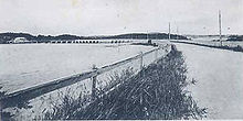
The Causeway, Bermuda
Encyclopedia
Land reclamation
Land reclamation, usually known as reclamation, is the process to create new land from sea or riverbeds. The land reclaimed is known as reclamation ground or landfill.- Habitation :...
and bridges in the north of Bermuda
Bermuda
Bermuda is a British overseas territory in the North Atlantic Ocean. Located off the east coast of the United States, its nearest landmass is Cape Hatteras, North Carolina, about to the west-northwest. It is about south of Halifax, Nova Scotia, Canada, and northeast of Miami, Florida...
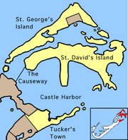
linking Hamilton Parish
Hamilton Parish, Bermuda
Hamilton Parish is one of the nine parishes of Bermuda. It was renamed for Scottish aristocrat James Hamilton, 2nd Marquess of Hamilton when he purchased the shares originally held in the Virginia Company by Lucy, Countess of Bedford.It is located in the northwest of the island chain, and is...
on the mainland in the southwest and Bermuda International Airport
Bermuda International Airport
L.F. Wade International Airport , formerly named Bermuda International Airport, is the sole airport serving Bermuda, a British overseas territory in the North Atlantic Ocean. It is located in the parish of St. George's and is northeast of Bermuda's capital city of Hamilton. In 2006, L.F. Wade...
on St. David's Island
St. David's Island, Bermuda
St. David's Island is one of the main islands of Bermuda. It is located in the far north of the territory, one of the two similarly sized islands that makeup the majority of St...
in St. George's Parish
St. George's Parish, Bermuda
St. George's Parish is one of the nine parishes of Bermuda. It is named after the founder of the Bermuda colony, Admiral Sir George Somers.It is located in the north-easternmost part of the island chain, containing a small part of the main island around Tucker's Town and the Tucker's Town...
in the northeast, which are otherwise divided by Castle Harbour
Castle Harbour, Bermuda
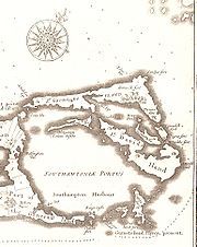
Castle Harbour is a large natural harbour in Bermuda. It is located between the northeastern end of the main island and St. David's Island. Originally called Southampton Port, it was renamed as a result of its heavy fortification in the early decades of the Seventeenth century.-Geography:A gem of...
.
The need for such a roadway was long-known to Bermuda's authorities. In the early 19th century, a committee was established to investigate possible plans. It would not be until 1867 that a valid plan, that by Lt. Albert Hime of the Royal Engineers
Royal Engineers
The Corps of Royal Engineers, usually just called the Royal Engineers , and commonly known as the Sappers, is one of the corps of the British Army....
, was approved.
Hime's Causeway was opened to traffic on 19 September 1871 by Governor Lefroy
John Henry Lefroy
Sir John Henry Lefroy, KCMG, CB, FRS, was a British military man and later colonial administrator who also distinguished himself with his scientific studies of the Earth's magnetism.- Biography :...
. The construction project cost £27,000 (in comparison, the local government raised only £25,000 in revenue for that year). Originally, it spanned from Blue Hole Hill, across the Cartwheel Islands (four small islets that are no longer visible) to Longbird Island. The project also included a new road in Bailey's Bay and across Longbird Island, and a swing bridge from Longbird to St. George's, finally giving an uninterrupted land route from the burgeoning main island to the old colony.
Until World War II
World War II
World War II, or the Second World War , was a global conflict lasting from 1939 to 1945, involving most of the world's nations—including all of the great powers—eventually forming two opposing military alliances: the Allies and the Axis...
, there were virtually no motor vehicles allowed in Bermuda, and only bicycles and horse-drawn carriages used the Causeway. The Bermuda Railway
Bermuda Railway
The Bermuda Railway was a common carrier line that operated in Bermuda for a brief period . In its 17 years of existence, the railway provided frequent passenger and freight service over its length spanning most of the archipelago from St...
operated island-wide, providing rail passenger and freight service between St. George's and Somerset in Sandys Parish, Bermuda
Sandys Parish, Bermuda
Sandys Parish is one of the nine parishes of Bermuda. It is named for English aristocrat Sir Edwin Sandys , and hence there is no apostrophe in the name, which is pronounced "Sands"....
. Consequently, the causeway was lightly used. With the construction of the Kindley Field airbase by the U.S. Army Air Force in 1942–1943 and the relaxation of the ban on motor vehicles for essential military uses during the wartime emergency, motorized vehicle use of the causeway increased significantly.
In the late 1940s, the Bermuda Government allowed civilian use of motor vehicles and the causeway became an essential part of Bermuda's transport infrastructure
Transport in Bermuda
Bermuda has of private paved roads; of public paved roads; of historic, mostly unpaved railroad trail, used in parts as a scenic trail; two marine ports , and one airport, the L.F. Wade International Airport, located at the former U.S. Naval Air Station. A causeway links Hamilton Parish, Bermuda...
for the average citizen.
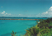
Throughout its existence, the causeway has suffered from damage due to hurricanes. On 1 September 1880, the causeway was wrecked by "the great storm". It was rebuilt following the original design, which stood until 14 September 1899, when three-fourth of a mile of the bridge was ravaged by another powerful hurricane. Afterwards, the causeway was rebuilt of stone block. Nearly a century later, in 1995, Hurricane Felix
Hurricane Felix (1995)
Hurricane Felix was the sixth named tropical cyclone and the third hurricane of the unusually active 1995 Atlantic hurricane season. Though the Cape Verde-type hurricane never made landfall, Felix stalled off the coast of North Carolina, resulting in great uncertainty over its track...
caused notable damage. Shortly after that, on 5 September 2003, Hurricane Fabian
Hurricane Fabian
Hurricane Fabian was a powerful Cape Verde-type hurricane that hit Bermuda in early September during the 2003 Atlantic hurricane season. Fabian, the sixth named storm, fourth hurricane, and first major hurricane of the season, developed from a tropical wave in the tropical Atlantic Ocean on August 25...
dealt critical damage, including the loss of four lives.
Following the damage inflicted by Hurricane Fabian, the Bermuda Government began investigating alternatives to simply repairing the Causeway after each storm knocked it out. These alternatives include an underwater tunnel, a true bridge and constructing additional roadways, such as through Coney Island
Coney Island, Bermuda
Coney Island is part of the chain which makes up Bermuda. It is located in St. George's Parish, in the northeast of the territory.The island cover 14.5 acres , close to the western entrance to Castle Harbor, southwest of the town of St. George's and close to the southern entrance to Ferry Reach....
and Ferry Reach
Ferry Reach, Bermuda
Ferry Reach is a three mile long channel in the north-east of Bermuda, which lies between St. George's Island in the north and St. David's Island in the south south-west of the town of St. George's.It extends south from St...
parks. Public meetings on these plans began in October, 2006.
By February 2010, however, plans to replace to Causeway had been abandoned, and the issue was a touchy subject when raised in Senate of Bermuda
Senate of Bermuda
The Senate is one of two parts of the Parliament of Bermuda, the other being the House of Assembly. Both are overseen by the Governor. The Senate is the Upper House of the Parliament, and serves as a House of Review....
.