

Greater Sudbury Road 55
Encyclopedia
Ontario
Ontario is a province of Canada, located in east-central Canada. It is Canada's most populous province and second largest in total area. It is home to the nation's most populous city, Toronto, and the nation's capital, Ottawa....
, Canada
Canada
Canada is a North American country consisting of ten provinces and three territories. Located in the northern part of the continent, it extends from the Atlantic Ocean in the east to the Pacific Ocean in the west, and northward into the Arctic Ocean...
. Extending from Whitefish to Coniston under a variety of street names, the road's entire length is a former alignment of Highway 17
Highway 17 (Ontario)
King's Highway 17, more commonly known as Highway 17, is a provincially maintained highway and the primary route of the Trans-Canada Highway through the Canadian province of Ontario. It begins at the Manitoba border west of Kenora and ends south of Arnprior at the western terminus of Highway 417, ...
and the Trans-Canada Highway
Trans-Canada Highway
The Trans-Canada Highway is a federal-provincial highway system that joins the ten provinces of Canada. It is, along with the Trans-Siberian Highway and Australia's Highway 1, one of the world's longest national highways, with the main route spanning 8,030 km...
.
The road's western terminus is a grade-level intersection with Highway 17 just west of Whitefish, approximately one kilometre east of where the four-lane freeway segment of Highway 17 begins. The intersection is expected to be converted to a full freeway interchange
Interchange (road)
In the field of road transport, an interchange is a road junction that typically uses grade separation, and one or more ramps, to permit traffic on at least one highway to pass through the junction without directly crossing any other traffic stream. It differs from a standard intersection, at which...
as the freeway is extended westward. Through the Walden
Walden, Ontario
Walden was a town in the Canadian province of Ontario, existing from 1973 to 2000. Created as part of the Regional Municipality of Sudbury when regional government was introduced, the town was dissolved when the city of Greater Sudbury was incorporated on January 1, 2001...
area, the road's only official street name is Municipal Road 55, although the informal name Old Highway 17 may also be used. In Waters, just west of Municipal Road 24 into Lively, the road widens into a dual carriageway
Dual carriageway
A dual carriageway is a class of highway with two carriageways for traffic travelling in opposite directions separated by a central reservation...
, and interchanges with Highway 17 just east of Mikkola. This portion of the route was decommissioned as part of the provincial highway system in 1980 with the construction of the freeway segment.
From the Mikkola interchange easterly, however, the route continued to hold the Highway 17 designation until the completion of the Southeast Bypass
Southwest and Southeast Bypasses (Sudbury)
The Southwest Bypass and Southeast Bypass are two separately-constructed roads in the city of Greater Sudbury, Ontario, that form a loop around the southern end of the city's urban core for traffic travelling on Highway 17, a route of the Trans-Canada Highway...
in 1995. This portion of the route continues east as an at-grade expressway
Limited-access road
A limited-access road known by various terms worldwide, including limited-access highway, dual-carriageway and expressway, is a highway or arterial road for high-speed traffic which has many or most characteristics of a controlled-access highway , including limited or no access to adjacent...
into Copper Cliff, where the median narrows to a paved strip until reaching the Big Nickel Road
Big Nickel
The Big Nickel is a nine-metre replica of a 1951 Canadian nickel, located at the grounds of Dynamic Earth in Sudbury, Ontario, Canada...
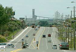
interchange. At that interchange, the road narrows back down to a single carriageway, albeit one with multiple lanes of traffic in each direction, and no longer has any access control. The roadway also picks up its first true street name, Lorne Street, at the same interchange. Lorne Street continues to travel in a northeasterly direction into Downtown, where the MR55 designation transfers onto Elm Street.
MR55 then follows the same roadway for the remainder of its length, although the street name transitions to Lloyd Street and later to The Kingsway. The section of The Kingsway east of Falconbridge Road is undergoing a $6 million expansion from two lanes to four lanes, with construction expected to be completed in 2008. The city has also planned a short westerly extension of the Kingsway, which will bypass the primarily residential Lloyd Street by connecting the Kingsway directly to the existing intersection of Lloyd and Brady Streets.
The road's eastern terminus is a signalized grade-level intersection with Highway 17 near Coniston. East of that intersection, the current route of Highway 17 is a continuation of the MR55 roadway — traffic using the highway's through route must turn at the intersection.
Future
As the freeway alignment of Highway 17 is extended eastward and westward from its existing termini, Municipal Road 55 may also be expanded to incorporate additional segments of the decommissioned highway alignment.The Ministry of Transportation
Ministry of Transportation (Ontario)
The Ministry of Transportation of Ontario is the provincial ministry of the government of Ontario which is responsible for transport infrastructure and related law in Ontario. The ministry traces its roots back over a century to the 1890s, when the province began training Provincial Road Building...
is currently undertaking planning studies on a further realignment of the Highway 17 route through Nickel Centre
Nickel Centre, Ontario
Nickel Centre was a town in Ontario, Canada, which existed from 1973 to 2000.It was created as part of the Regional Municipality of Sudbury. On January 1, 2001, the town and the Regional Municipality were dissolved and amalgamated into the city of Greater Sudbury...
toward Markstay. As well, a six-kilometre westerly extension of the existing freeway alignment in the Whitefish area, including a conversion of the existing Municipal Road 55 intersection to a full interchange, is currently in the planning stage. However, actual construction dates have not yet been announced for either project as of 2010.