
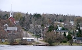
Bonfield, Ontario
Encyclopedia
Township (Canada)
The term township generally means the district or area associated with a town. However in some systems no town needs to be involved. The specific use of the term to describe political subdivisions has varied by country, usually to describe a local rural or semi-rural government within the county...
in northeastern Ontario
Ontario
Ontario is a province of Canada, located in east-central Canada. It is Canada's most populous province and second largest in total area. It is home to the nation's most populous city, Toronto, and the nation's capital, Ottawa....
, Canada
Canada
Canada is a North American country consisting of ten provinces and three territories. Located in the northern part of the continent, it extends from the Atlantic Ocean in the east to the Pacific Ocean in the west, and northward into the Arctic Ocean...
, on the Mattawa River
Mattawa River
The Mattawa River is a river in central Ontario, Canada. It flows east from Trout Lake east of North Bay and enters the Ottawa River at the town of Mattawa. Counting from the head of Trout Lake, it is 76 km in length...
in Nipissing District
Nipissing District, Ontario
Nipissing District, Ontario is a district in Northeastern Ontario in the Canadian province of Ontario. It was created in 1858. The district seat is North Bay.In 2006, the population was 84,688...
.
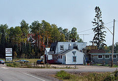
The township comprises the communities of Blanchard's Landing, Bonfield, Grand Desert, and Rutherglen. The community of Bonfield is connected to Ontario Highway 17
Highway 17 (Ontario)
King's Highway 17, more commonly known as Highway 17, is a provincially maintained highway and the primary route of the Trans-Canada Highway through the Canadian province of Ontario. It begins at the Manitoba border west of Kenora and ends south of Arnprior at the western terminus of Highway 417, ...
by Ontario Highway 531
Highway 531 (Ontario)
Secondary Highway 531, commonly referred to as Highway 531, is a provincially maintained secondary highway in the Canadian province of Ontario. It connects Highway 17 east of North Bay with the community of Bonfield. The route was established in 1956, and has remained the same since then...
, while Rutherglen is located directly on the route of Highway 17 and the other communities are located on local roads within the township.
In 2007, Bonfield, along with the town of Mattawa
Mattawa, Ontario
Mattawa is a town in northeastern Ontario, Canada, at the confluence of the Mattawa and Ottawa Rivers in Nipissing District. Mattawa means "Meeting of the Waters" in Ojibwa...
and the townships of Papineau-Cameron
Papineau-Cameron, Ontario
Papineau-Cameron is a municipal township in northeastern Ontario, Canada, in Nipissing District. The township is located on the south side of the Mattawa and Ottawa Rivers along Highway 17....
, Mattawan
Mattawan, Ontario
Mattawan is a township in the Canadian province of Ontario. Located in the Nipissing District, the township had a population of 147 in the Canada 2006 Census....
and Calvin
Calvin, Ontario
Calvin is a township in northeastern Ontario, Canada on the Mattawa River in Nipissing District. The township took its name from Delino Dexter Calvin, an Ontario lumber merchant and MPP based in Frontenac County....
cooperated to create a newly-branded Mattawa Voyageur Country tourist region in order to promote the area.
History
The community of Bonfield was first settled in 1882 as a station on the Canadian Pacific RailwayCanadian Pacific Railway
The Canadian Pacific Railway , formerly also known as CP Rail between 1968 and 1996, is a historic Canadian Class I railway founded in 1881 and now operated by Canadian Pacific Railway Limited, which began operations as legal owner in a corporate restructuring in 2001...
.
Located on the north shore of Lake Nosbonsing
Lake Nosbonsing
Lake Nosbonsing is a lake of Ontario, Canada, near the City of North Bay....
, where the railway crosses the Kaibuskong River
Kaibuskong River
The Kaibuskong River is a small river in Nipissing District in northeastern Ontario, Canada that runs south through the Township of Bonfield from its source at Lake Nosbonsing...
, this place was originally named by the CPR as Callander Station. The community of Callander
Callander, Ontario
The Municipality of Callander is a township in central Ontario, Canada, located at the southeast end of Lake Nipissing in the District of Parry Sound...
, on the South-East Bay of Lake Nipissing
Lake Nipissing
Lake Nipissing is a lake in the Canadian province of Ontario. It has a surface area of , a mean elevation of above sea level, and is located between the Ottawa River and Georgian Bay. Excluding the Great Lakes, Lake Nipissing is the fifth-largest lake in Ontario. It is relatively shallow for a...
, had been named Callander in 1880, to honour the birthplace in Scotland
Scotland
Scotland is a country that is part of the United Kingdom. Occupying the northern third of the island of Great Britain, it shares a border with England to the south and is bounded by the North Sea to the east, the Atlantic Ocean to the north and west, and the North Channel and Irish Sea to the...
of Duncan McIntyre, then president of the Canada Central Railway (CCR). It was at this place on the shore of Lake Nipissing, that the CCR intended to connect with the proposed eastern terminus of the CPR. In 1881 the Canada Central Railway was merged into the Canadian Pacific, as McIntyre became its vice president. As construction of the railway approached Lake Nipissing from the east, it turned away from the South-East Bay, towards the North Bay of Lake Nipissing instead. This was the closest point the CPR would come to the village of Callander, therefore this place was named Callander Station.
After the Northern and Pacific Junction Railway
Northern Railway of Canada
The Northern Railway of Canada was a historical Canadian railway located in the province of Ontario. It was eventually acquired by the Grand Trunk Railway, and is therefore a predecessor to the modern Canadian National Railway.- Early history :...
established a station in the original village of Callander in 1886 and was taken over by the Grand Trunk Railway
Grand Trunk Railway
The Grand Trunk Railway was a railway system which operated in the Canadian provinces of Quebec and Ontario, as well as the American states of Connecticut, Maine, Michigan, Massachusetts, New Hampshire, and Vermont. The railway was operated from headquarters in Montreal, Quebec; however, corporate...
in 1888, there was much confusion between the station in Callander and Callander Station. The CPR location, Callander Station was renamed Bonfield, adopting the name of the township in which it is located.
Demographics
According to the Canada 2006 CensusCanada 2006 Census
The Canada 2006 Census was a detailed enumeration of the Canadian population. Census day was May 16, 2006. The next census following will be the 2011 Census. Canada's total population enumerated by the 2006 census was 31,612,897...
:
- Population: 1,981
- % Change (2001-2006): -2.7
- Dwellings: 851
- Area (km²): 205.75
- Density (persons per km²): 9.8
According to the Canada 2001 Census
Canada 2001 Census
The Canada 2001 Census was a detailed enumeration of the Canadian population. Census day was May 15, 2001. On that day, Statistics Canada attempted to count every person in Canada. The total population count of Canada was 30,007,094. This was a 4% increase over 1996 Census of 28,846,761. In...
:
- Population: 2,064
- % Change (1996-2001): 16.9
- Dwellings: 963
- Area (km²): 205.75
- Density (persons per km²): 10.0