

Regional Road 174
Encyclopedia
Ottawa
Ottawa is the capital of Canada, the second largest city in the Province of Ontario, and the fourth largest city in the country. The city is located on the south bank of the Ottawa River in the eastern portion of Southern Ontario...
which serves the eastern suburbs of Orléans
Orléans, Ontario
Orleans , also written Orléans, is a suburban area within the city of Ottawa, Ontario, Canada. It is located in the eastern part of the city along the Ottawa River, about from downtown Ottawa. The Canada 2006 Census gave Orleans a population of 95,491. It became a ward of the City of Ottawa in 2001...
and Cumberland
Cumberland, Ontario
Cumberland was a township in eastern Ontario, Canada, that existed from 1800 to 1999, when it was incorporated as the City of Cumberland. It ceased to be a separate municipality in 2001, when it was amalgamated into the city of Ottawa.-History:...
. Although the road continues through the towns of Rockland
Rockland, Ontario
Rockland is a bilingual community located about east of downtown Ottawa, Ontario, Canada, part of the city of Clarence–Rockland. Rockland has a population of 9,210.-History:...
and Hawkesbury
Hawkesbury, Ontario
Hawkesbury is a town in the Eastern portion of Southern Ontario, Canada, on the Ottawa River, near the Quebec-Ontario border.It lies on the south shore of the Ottawa River about halfway between Downtown Ottawa and Downtown Montreal in Prescott and Russell Counties. The Long-Sault Bridge links it...
to the Quebec
Quebec
Quebec or is a province in east-central Canada. It is the only Canadian province with a predominantly French-speaking population and the only one whose sole official language is French at the provincial level....
border, the portion east of the Ottawa city boundaries is known as Prescott and Russell County Road 17. Originally the alignment of Highway 17 between Ottawa and the Quebec border, Regional Road 174 was created on April 1, 1997 when the Provincial government of Mike Harris
Mike Harris
Michael Deane "Mike" Harris was the 22nd Premier of Ontario from June 26, 1995 to April 15, 2002. He is most noted for the "Common Sense Revolution", his Progressive Conservative government's program of deficit reduction in combination with lower taxes and cuts to government...
transferred responsibility for portions of the road to the Regional Municipality of Ottawa–Carleton. The road was extended by a second transfer on January 1, 1998, bringing it to its current length.
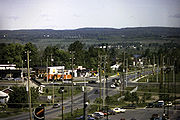
Route description

OC Transpo
OC Transpo is the urban transit service of the City of Ottawa, Ontario, Canada. An integrated hub-and-spoke system of services is available consisting of: regular buses travelling on fixed routes in mixed traffic, typical of most urban transit systems; a bus rapid transit system — a high...
lanes in each direction from just east of Blair Road
Blair Road (Ottawa)
Blair Road is a road in the eastern part of Ottawa, Ontario, Canada. It begins just south of the Rockcliffe Parkway, but does not connect to the parkway, except for a small bike-path connection to the Ottawa River Pathway - one of the city's main bike trails that runs along the Ottawa...
to Place d'Orleans
Place d'Orleans
Place d'Orléans is a large shopping mall in the eastern end of Ottawa, Ontario, Canada, in the community of Orléans. The property is about . It currently holds three large department stores and about 175 small shops, including a food court...
. East of Trim Road, it becomes a two-lane rural highway until the Prescott-Russell County Line which is named Prescott-Russell Road 17 until the eastern end at Highway 417 east of Hawkesbury
Hawkesbury, Ontario
Hawkesbury is a town in the Eastern portion of Southern Ontario, Canada, on the Ottawa River, near the Quebec-Ontario border.It lies on the south shore of the Ottawa River about halfway between Downtown Ottawa and Downtown Montreal in Prescott and Russell Counties. The Long-Sault Bridge links it...
. Over the past years, traffic between Highway 417 and Rockland became much heavier due to suburban growth in Orléans and Rockland leading to frequent congestion during peak hours. Meanwhile, the eastern most portion of the road was regarded as dangerous due to several fatal accidents. In 2007, both provincial and federal government committed some fundings for the widening of Regional Road 174 between Trim Road
Trim Road (Ottawa)
Trim Road is an arterial road in the eastern end of Orléans, Ontario . It serves as the only road access to Petrie Island and its public beach in the Ottawa River. From Petrie Island, Trim runs south through the eastern suburban areas of Orleans and then south into rural former Cumberland Township...
and Rockland, although the widening construction project was still several years away. However, in April 2008, Ottawa City Council refused a $80 million funding for both provincial and federal governments citing it would not benefit to the City of Ottawa which would delay the construction indefinitely.