
Petawawa, Ontario
Overview
Petawawa is a town
located in eastern portion of Southern
Ontario
. Situated in the Ottawa Valley
, with a population
of 14,651 (2006 Census). Petawawa is the most populous municipality
in Renfrew County
.
Petawawa is located at latitude
45°54' north and longitude
77°17' west.
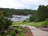
The town lies on the west bank of the Ottawa River
, at the confluence
of the Petawawa River
. Situated across the Ottawa River from the Laurentian Mountains
, and east of Algonquin Park,
Petawawa is a favourite stop for outdoor enthusiasts, anglers, hikers
, canoe
rs, and kayak
ers.
Ontario Highway 17
, Greyhound bus lines
, and the local commercial airport (Pembroke Airport
) located in Petawawa, all provide access to this town.
Petawawa's primary employer is the Canadian Government.
Town
A town is a human settlement larger than a village but smaller than a city. The size a settlement must be in order to be called a "town" varies considerably in different parts of the world, so that, for example, many American "small towns" seem to British people to be no more than villages, while...
located in eastern portion of Southern
Southern Ontario
Southern Ontario is a region of the province of Ontario, Canada that lies south of the French River and Algonquin Park. Depending on the inclusion of the Parry Sound and Muskoka districts, its surface area would cover between 14 to 15% of the province. It is the southernmost region of...
Ontario
Ontario
Ontario is a province of Canada, located in east-central Canada. It is Canada's most populous province and second largest in total area. It is home to the nation's most populous city, Toronto, and the nation's capital, Ottawa....
. Situated in the Ottawa Valley
Ottawa Valley
The Ottawa Valley is the valley along the boundary between Eastern Ontario and Western Quebec along the Ottawa River. The valley is the transition between the Saint Lawrence Lowlands and the Canadian Shield...
, with a population
Population
A population is all the organisms that both belong to the same group or species and live in the same geographical area. The area that is used to define a sexual population is such that inter-breeding is possible between any pair within the area and more probable than cross-breeding with individuals...
of 14,651 (2006 Census). Petawawa is the most populous municipality
Municipality
A municipality is essentially an urban administrative division having corporate status and usually powers of self-government. It can also be used to mean the governing body of a municipality. A municipality is a general-purpose administrative subdivision, as opposed to a special-purpose district...
in Renfrew County
Renfrew County, Ontario
Renfrew is a county in the Canadian province of Ontario. In 2006, the population was 97,545 and county covered , giving a population density of . There are 17 official municipalities.-Government:...
.
Petawawa is located at latitude
Latitude
In geography, the latitude of a location on the Earth is the angular distance of that location south or north of the Equator. The latitude is an angle, and is usually measured in degrees . The equator has a latitude of 0°, the North pole has a latitude of 90° north , and the South pole has a...
45°54' north and longitude
Longitude
Longitude is a geographic coordinate that specifies the east-west position of a point on the Earth's surface. It is an angular measurement, usually expressed in degrees, minutes and seconds, and denoted by the Greek letter lambda ....
77°17' west.
The town lies on the west bank of the Ottawa River
Ottawa River
The Ottawa River is a river in the Canadian provinces of Ontario and Quebec. For most of its length, it now defines the border between these two provinces.-Geography:...
, at the confluence
Confluence
Confluence, in geography, describes the meeting of two or more bodies of water.Confluence may also refer to:* Confluence , a property of term rewriting systems...
of the Petawawa River
Petawawa River
The Petawawa River is a river in the Saint Lawrence River drainage basin in Nipissing District and Renfrew County in eastern and northeastern Ontario, Canada. The river flows from Algonquin Provincial Park to the Ottawa River at the town of Petawawa...
. Situated across the Ottawa River from the Laurentian Mountains
Laurentian mountains
The Laurentian Mountains are a mountain range in southern Quebec, Canada, north of the St. Lawrence River and Ottawa River, rising to a highest point of 1166 metres at Mont Raoul Blanchard, north east of Quebec City in the Reserve Faunique des Laurentides. The Gatineau, L'Assomption, Lièvre,...
, and east of Algonquin Park,
Petawawa is a favourite stop for outdoor enthusiasts, anglers, hikers
Hiking
Hiking is an outdoor activity which consists of walking in natural environments, often in mountainous or other scenic terrain. People often hike on hiking trails. It is such a popular activity that there are numerous hiking organizations worldwide. The health benefits of different types of hiking...
, canoe
Canoe
A canoe or Canadian canoe is a small narrow boat, typically human-powered, though it may also be powered by sails or small electric or gas motors. Canoes are usually pointed at both bow and stern and are normally open on top, but can be decked over A canoe (North American English) or Canadian...
rs, and kayak
Kayak
A kayak is a small, relatively narrow, human-powered boat primarily designed to be manually propelled by means of a double blade paddle.The traditional kayak has a covered deck and one or more cockpits, each seating one paddler...
ers.
Ontario Highway 17
Highway 17 (Ontario)
King's Highway 17, more commonly known as Highway 17, is a provincially maintained highway and the primary route of the Trans-Canada Highway through the Canadian province of Ontario. It begins at the Manitoba border west of Kenora and ends south of Arnprior at the western terminus of Highway 417, ...
, Greyhound bus lines
Greyhound Lines
Greyhound Lines, Inc., based in Dallas, Texas, is an intercity common carrier of passengers by bus serving over 3,700 destinations in the United States, Canada and Mexico, operating under the well-known logo of a leaping greyhound. It was founded in Hibbing, Minnesota, USA, in 1914 and...
, and the local commercial airport (Pembroke Airport
Pembroke Airport
Pembroke Airport, , is located northwest of the city of Pembroke, Ontario, Canada.Pem-Air operated regularly scheduled air service between Pembroke Airport and Toronto for 31 years; ending its scheduled operation in December, 2000....
) located in Petawawa, all provide access to this town.
Petawawa's primary employer is the Canadian Government.
Unanswered Questions