
Thunder Bay Expressway
Encyclopedia
The Thunder Bay Expressway is a four lane highway with signalized
intersections running on the western edge of Thunder Bay
, Ontario
, Canada
.
Barrie, Ontario
).
The Thunder Bay Expressway has the unsigned designation of Highway 7250 and forms the southernmost portion of the Terry Fox
Courage Highway, which continues east to Nipigon along the Trans-Canada Highway. Between Arthur Street and the Harbour Expressway
, it shares a designation with Ontario highway 61
. Between the Harbour Expressway and its eastern terminus at Hodder Avenue, it shares a designation with highways 11
and 17
, a portion of the Trans-Canada Highway
.
The entire route is four lanes and undivided, with an exception between Balsam Street and Hodder Avenue where the route is twinned. Its intersections are all at-grade. Plans to entirely twin the highway and build interchanges were abandoned in the 1990s. The city of Thunder Bay maintains a right of way for these expansion plans in its official plan, and in some places there is evidence of these plans. However, the province of Ontario has recently announced funding to twin the Trans-Canada Highway from Thunder Bay to Nipigon
. This should bring long-awaited upgrades to the expressway.
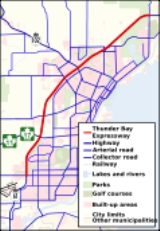
The highway runs along the western edge of Thunder Bay south and bisects the northwest portion of Thunder Bay north. The bulk of its traffic is local but it is also an important route in the Trans-Canada highway network.
on the Thunder Bay Expressway. The intersections on the expressway are unnumbered
.
Traffic light
Traffic lights, which may also be known as stoplights, traffic lamps, traffic signals, signal lights, robots or semaphore, are signalling devices positioned at road intersections, pedestrian crossings and other locations to control competing flows of traffic...
intersections running on the western edge of Thunder Bay
Thunder Bay
-In Canada:Thunder Bay is the name of three places in the province of Ontario, Canada along Lake Superior:*Thunder Bay District, Ontario, a district in Northwestern Ontario*Thunder Bay, a city in Thunder Bay District*Thunder Bay, Unorganized, Ontario...
, Ontario
Ontario
Ontario is a province of Canada, located in east-central Canada. It is Canada's most populous province and second largest in total area. It is home to the nation's most populous city, Toronto, and the nation's capital, Ottawa....
, Canada
Canada
Canada is a North American country consisting of ten provinces and three territories. Located in the northern part of the continent, it extends from the Atlantic Ocean in the east to the Pacific Ocean in the west, and northward into the Arctic Ocean...
.
Route description
During construction in the 1970s, the road had the temporary designation of Highway 131 (which was later recycled for a highway nearHighway 131 (Ontario)
Highway 131 was a provincially maintained highway in the Canadian province of Ontario, located in Simcoe County and the city of Barrie. The route, which connected Highway 27 with Highway 90, existed from 1984 through 1997, after which it was transferred to the responsibility of Simcoe...
Barrie, Ontario
Barrie, Ontario
Barrie is a city in Southern Ontario, Canada, located on the western shore of Lake Simcoe, approximately 90 km north of Toronto. Although located in Simcoe County, the city is politically independent...
).
The Thunder Bay Expressway has the unsigned designation of Highway 7250 and forms the southernmost portion of the Terry Fox
Terry Fox
Terrance Stanley "Terry" Fox , was a Canadian humanitarian, athlete, and cancer research activist. In 1980, with one leg having been amputated, he embarked on a cross-Canada run to raise money and awareness for cancer research...
Courage Highway, which continues east to Nipigon along the Trans-Canada Highway. Between Arthur Street and the Harbour Expressway
Harbour Expressway
The Harbour Expressway is a four lane highway with signalized intersections running the Intercity business district of Thunder Bay, Ontario, Canada....
, it shares a designation with Ontario highway 61
Highway 61 (Ontario)
King's Highway 61, commonly referred to as Highway 61 and historically known as the Scott Highway, is a provincially maintained highway in the Canadian province of Ontario. It connects the Pigeon River Bridge, where it crosses into the United States and becomes Minnesota State Highway 61, with a...
. Between the Harbour Expressway and its eastern terminus at Hodder Avenue, it shares a designation with highways 11
Highway 11 (Ontario)
King's Highway 11 is a provincially maintained highway in the Canadian province of Ontario. At , it is the second longest highway in the province after Highway 17. Highway 11 begins at Highway 400 in Barrie, and arches through northern Ontario, around Lake Superior, to the Ontario–Minnesota border...
and 17
Highway 17 (Ontario)
King's Highway 17, more commonly known as Highway 17, is a provincially maintained highway and the primary route of the Trans-Canada Highway through the Canadian province of Ontario. It begins at the Manitoba border west of Kenora and ends south of Arnprior at the western terminus of Highway 417, ...
, a portion of the Trans-Canada Highway
Trans-Canada Highway
The Trans-Canada Highway is a federal-provincial highway system that joins the ten provinces of Canada. It is, along with the Trans-Siberian Highway and Australia's Highway 1, one of the world's longest national highways, with the main route spanning 8,030 km...
.
The entire route is four lanes and undivided, with an exception between Balsam Street and Hodder Avenue where the route is twinned. Its intersections are all at-grade. Plans to entirely twin the highway and build interchanges were abandoned in the 1990s. The city of Thunder Bay maintains a right of way for these expansion plans in its official plan, and in some places there is evidence of these plans. However, the province of Ontario has recently announced funding to twin the Trans-Canada Highway from Thunder Bay to Nipigon
Nipigon, Ontario
Nipigon is a township in Thunder Bay District, Northwestern Ontario, Canada, located along the west side of the Nipigon River and south of the small Lake Helen running between Lake Nipigon and Lake Superior...
. This should bring long-awaited upgrades to the expressway.
The highway runs along the western edge of Thunder Bay south and bisects the northwest portion of Thunder Bay north. The bulk of its traffic is local but it is also an important route in the Trans-Canada highway network.
List of intersections
The following is a list of intersectionsIntersection (road)
An intersection is a road junction where two or more roads either meet or cross at grade . An intersection may be 3-way - a T junction or fork, 4-way - a crossroads, or 5-way or more...
on the Thunder Bay Expressway. The intersections on the expressway are unnumbered
Exit number
An exit number is a number assigned to a road junction, usually an exit from a freeway. It is usually marked on the same sign as the destinations of the exit, as well as a sign in the gore....
.
| km | Intersecting road(s) | Notes |
|---|---|---|
| 0.0 | Arthur Street | North as Highway 61 Highway 61 (Ontario) King's Highway 61, commonly referred to as Highway 61 and historically known as the Scott Highway, is a provincially maintained highway in the Canadian province of Ontario. It connects the Pigeon River Bridge, where it crosses into the United States and becomes Minnesota State Highway 61, with a... |
| 3.0 | East: Highway 11 Highway 11 (Ontario) King's Highway 11 is a provincially maintained highway in the Canadian province of Ontario. At , it is the second longest highway in the province after Highway 17. Highway 11 begins at Highway 400 in Barrie, and arches through northern Ontario, around Lake Superior, to the Ontario–Minnesota border... /17 Highway 17 (Ontario) King's Highway 17, more commonly known as Highway 17, is a provincially maintained highway and the primary route of the Trans-Canada Highway through the Canadian province of Ontario. It begins at the Manitoba border west of Kenora and ends south of Arnprior at the western terminus of Highway 417, ... (Shabaqua Highway) (Trans-Canada) West: Harbour Expressway Harbour Expressway The Harbour Expressway is a four lane highway with signalized intersections running the Intercity business district of Thunder Bay, Ontario, Canada.... |
Highway 61 designation ends Highway 11 Highway 11 (Ontario) King's Highway 11 is a provincially maintained highway in the Canadian province of Ontario. At , it is the second longest highway in the province after Highway 17. Highway 11 begins at Highway 400 in Barrie, and arches through northern Ontario, around Lake Superior, to the Ontario–Minnesota border... /17 Highway 17 (Ontario) King's Highway 17, more commonly known as Highway 17, is a provincially maintained highway and the primary route of the Trans-Canada Highway through the Canadian province of Ontario. It begins at the Manitoba border west of Kenora and ends south of Arnprior at the western terminus of Highway 417, ... (Trans-Canada) designation begins |
| 4.6 | Oliver Road | |
| 7.7 | John Street | |
| 8.9 | East: Red River Road West: Dawson Road |
Dawson Road becomes Highway 102 Highway 102 (Ontario) King's Highway 102, commonly referred to as Highway 102, formerly as Highway 11A and Highway 17A and historically as the Dawson Road, is a provincially maintained highway in the Canadian province of Ontario, serving as a northern bypass to the city of Thunder Bay.Both the western and eastern... at Strand Avenue, 300m west. |
| 10.9 | Huron Avenue | One-way off-ramp, eastbound. |
| 11.2 | Balsam Street | Highway is divided between km 11.6 and 15.2 |
| 15.3 | North: Copenhagen Road South: Hodder Avenue |
Thunder Bay Expressway designation ends. Highway 11/17 and Terry Fox Courage Highway designations continue. |
AADT 2004
| Location | AADT |
|---|---|
| Chippewa Rd.to Broadway Ave. | 10,000 |
| Broadway Ave. to Neebing Ave./ Princess St. | 13,200 |
| Neebing Ave./ Princess St. to Arthur St. | 16,900 |
| Arthur St. to Harbour Expressway Harbour Expressway The Harbour Expressway is a four lane highway with signalized intersections running the Intercity business district of Thunder Bay, Ontario, Canada.... / Highway 11 Highway 11 (Ontario) King's Highway 11 is a provincially maintained highway in the Canadian province of Ontario. At , it is the second longest highway in the province after Highway 17. Highway 11 begins at Highway 400 in Barrie, and arches through northern Ontario, around Lake Superior, to the Ontario–Minnesota border... /17 Highway 17 (Ontario) King's Highway 17, more commonly known as Highway 17, is a provincially maintained highway and the primary route of the Trans-Canada Highway through the Canadian province of Ontario. It begins at the Manitoba border west of Kenora and ends south of Arnprior at the western terminus of Highway 417, ... |
22,100 |
| Harbour Expressway Harbour Expressway The Harbour Expressway is a four lane highway with signalized intersections running the Intercity business district of Thunder Bay, Ontario, Canada.... / Highway 11 Highway 11 (Ontario) King's Highway 11 is a provincially maintained highway in the Canadian province of Ontario. At , it is the second longest highway in the province after Highway 17. Highway 11 begins at Highway 400 in Barrie, and arches through northern Ontario, around Lake Superior, to the Ontario–Minnesota border... /17 Highway 17 (Ontario) King's Highway 17, more commonly known as Highway 17, is a provincially maintained highway and the primary route of the Trans-Canada Highway through the Canadian province of Ontario. It begins at the Manitoba border west of Kenora and ends south of Arnprior at the western terminus of Highway 417, ... to Oliver Rd. |
17,400 |
| Oliver Rd. to John St. | 18.000 |
| John St. to Red River Rd./ Highway 102 (Dawson Rd.) Highway 102 (Ontario) King's Highway 102, commonly referred to as Highway 102, formerly as Highway 11A and Highway 17A and historically as the Dawson Road, is a provincially maintained highway in the Canadian province of Ontario, serving as a northern bypass to the city of Thunder Bay.Both the western and eastern... |
15,500 |
| Red River Rd./ Highway 102 (Dawson Rd.) Highway 102 (Ontario) King's Highway 102, commonly referred to as Highway 102, formerly as Highway 11A and Highway 17A and historically as the Dawson Road, is a provincially maintained highway in the Canadian province of Ontario, serving as a northern bypass to the city of Thunder Bay.Both the western and eastern... to Balsam St. |
12,800 |
| Balsam St. to Hodder Ave./Copenhagen Rd. | 7,850 |