
Frederick County, Maryland
Encyclopedia
Frederick County is a county located in the western part of the U.S. state
of Maryland
, bordering the southern border of Pennsylvania
and the northeastern border of Virginia
. As of the 2010 Census, the population was 233,385.
It is a part of the Washington-Baltimore Metropolitan Area
, and is often recognized as part of Western Maryland
. The county is home to Catoctin Mountain Park
(encompassing the presidential
retreat Camp David
) and to the U.S. Army's Fort Detrick
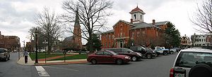
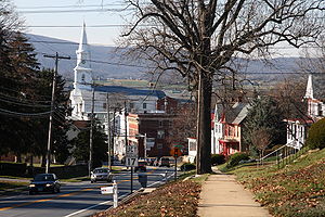
. The county seat
is Frederick
, which was home to several celebrated historical figures like Francis Scott Key
, Thomas Johnson (governor)
, Roger B. Taney
, and Barbara Fritchie. The county (and the county seat) may have been named for Frederick Calvert, 6th Baron Baltimore
.
and Baltimore County
.
In 1776, Frederick County was divided into three parts. The westernmost portion became Washington County
, named after George Washington
, the easternmost portion became Montgomery County
, named after another Revolutionary War
general, Richard Montgomery
. The central portion remained Frederick County.
In 1837 a part of Frederick County was combined with a part of Baltimore County to form Carroll County
.
The county has a number of properties on the National Register of Historic Places
.
The Frederick County State's Attorney, elected November 2, 2010, is Republican Charlie Smith. The sheriff of Frederick County is Republican Chuck Jenkins. The Executive Director for the Frederick County Office of Economic Development is Laurie Boyer.
Frederick County is one of the most historically Republican counties in Maryland. It has not voted for a Democrat for president since 1964 when it voted for Lyndon B. Johnson
. In 2004 George W. Bush
defeated John Kerry
59-39%. Democrats came closer in 2008, when John McCain
defeated Barack Obama
by a mere 1,157 votes (49.62-48.58). Nevertheless, Republicans in Frederick rebounded to more historical levels in the 2010 Maryland Gubernatorial & Senatorial Elections, giving the Republican Ehrlich/Kane ticket 55% to Democrat O'Malley/Brown's 45. Frederick voters also supported Republican Senate challenger Eric Wargotz over incumbent Democratic Senator Barbara A Milkulski by a margin of 51-46, even as Mikulski was winning statewide by a landslide 61-37.
Frederick County's Fire Service is handled by a Combination system. Currently employing over 350 firefighters, this makes Frederick County the 5th largest Fire Department in Maryland. The dwindling volunteers of the 26 departments number in the range of 200-400 with the majority being fire police and administrative personnel. Career firefighters and EMT's are the primary responders on all incidents with the volunteers only providing canteen and fire police services. EMS service is delivered by Career Firefighter/EMT's along with career ALS service. Frederick County has a MD State Police Medevac located at the Frederick Municipal Airport and is designated "Trooper 3". Trooper 3 handles calls all throughout the state, but provides immediate assistance to local Police Departments and the Career Fire Department.
 According to the 2000 census, the county has a total area of 667.34 square miles (1,728.4 km²), of which 662.88 square miles (1,716.9 km²) (or 99.33%) is land and 4.46 square miles (11.6 km²) (or 0.67%) is water. It is the largest county in Maryland in terms of area.
Attractions in the Frederick area include the Clustered Spires, a monument
to Francis Scott Key
, the National Museum of Civil War Medicine
, Monocacy National Battlefield
and South Mountain
battlefields, and the Schifferstadt Architectural Museum.
>
Year
Population
1900
51,920
1910
52,673
1920
52,541
1930
54,440
1940
57,312
1950
62,287
1960
71,930
1970
84,927
1980
114,792
1990
150,208
2000
195,277
2010
233,385
In the county the population was spread out with 25.3% under the age of 18, 8.4% from 18 to 24, 26.7% from 25 to 44, 28.6% from 45 to 64, and 11.1% who were 65 years of age or older. The median age was 38.6 years. For every 100 females there were 96.85 males. For every 100 females age 18 and over, there were 94.02 males.
for the county was $25,404. About 2.90% of families and 4.50% of the population were below the poverty line, including 4.90% of those under age 18 and 6.00% of those age 65 or over.
Fort Detrick
is the largest employer in Frederick County. The largest employers aside from the government are the Frederick Memorial Healthcare System, Bechtel
, SAIC
and Wells Fargo
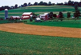
. Frederick County has a strong agricultural
component of its economy, and it is the largest producer of milk
in Maryland.
 As of the census
of 2010, there were 233,385 people, 84,800 households, and 61,198 families residing in the county. The population density
was 295 people per square mile (114/km²). There were 90,136 housing units at an average density of 110/square mile (43/km²). The racial makeup of the county was 81.5% White
, 8.6% Black
or African American
, 0.3% Native American
, 3.8% Asian
, 0.045% Pacific Islander
, 2.9% from other races
, and 2.8% from two or more races. 7.3% of the population were Hispanic
or Latino
of any race. According to Census 2000 24.7% were of German, 12.9% American, 12.3% Irish
and 10.1% English
ancestry.
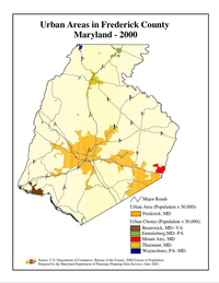
 Frederick County contains the following incorporated municipalities:
Unincorporated areas are also considered as towns by many people and listed in many collections of towns, but they lack local government. Various organizations, such as the United States Census Bureau
, the United States Postal Service
, and local chambers of commerce, define the communities they wish to recognize differently, and since they are not incorporated, their boundaries have no official status outside the organizations in question. The Census Bureau recognizes the following census-designated place
s in the county:
Other unincorporated areas include:
U.S. state
A U.S. state is any one of the 50 federated states of the United States of America that share sovereignty with the federal government. Because of this shared sovereignty, an American is a citizen both of the federal entity and of his or her state of domicile. Four states use the official title of...
of Maryland
Maryland
Maryland is a U.S. state located in the Mid Atlantic region of the United States, bordering Virginia, West Virginia, and the District of Columbia to its south and west; Pennsylvania to its north; and Delaware to its east...
, bordering the southern border of Pennsylvania
Pennsylvania
The Commonwealth of Pennsylvania is a U.S. state that is located in the Northeastern and Mid-Atlantic regions of the United States. The state borders Delaware and Maryland to the south, West Virginia to the southwest, Ohio to the west, New York and Ontario, Canada, to the north, and New Jersey to...
and the northeastern border of Virginia
Virginia
The Commonwealth of Virginia , is a U.S. state on the Atlantic Coast of the Southern United States. Virginia is nicknamed the "Old Dominion" and sometimes the "Mother of Presidents" after the eight U.S. presidents born there...
. As of the 2010 Census, the population was 233,385.
It is a part of the Washington-Baltimore Metropolitan Area
Washington Metropolitan Area
The Washington Metropolitan Area is the metropolitan area centered on Washington, D.C., the capital of the United States. The area includes all of the federal district and parts of the U.S...
, and is often recognized as part of Western Maryland
Western Maryland
Western Maryland is the portion of the U.S. state of Maryland that consists of Frederick, Washington, Allegany, and Garrett counties. The region is bounded by the Mason-Dixon line to the north, Preston County, West Virginia to the west, and the Potomac River to the south. There is dispute over the...
. The county is home to Catoctin Mountain Park
Catoctin Mountain Park
Catoctin Mountain Park, located in north-central Maryland, is part of the forested Catoctin Mountain ridge that forms the eastern rampart of the Appalachian Mountains...
(encompassing the presidential
President of the United States
The President of the United States of America is the head of state and head of government of the United States. The president leads the executive branch of the federal government and is the commander-in-chief of the United States Armed Forces....
retreat Camp David
Camp David
Camp David is the country retreat of the President of the United States and his guests. It is located in low wooded hills about 60 mi north-northwest of Washington, D.C., on the property of Catoctin Mountain Park in unincorporated Frederick County, Maryland, near Thurmont, at an elevation of...
) and to the U.S. Army's Fort Detrick
Fort Detrick
Fort Detrick is a U.S. Army Medical Command installation located in Frederick, Maryland, USA. Historically, Fort Detrick was the center for the United States' biological weapons program ....
. The county seat
County seat
A county seat is an administrative center, or seat of government, for a county or civil parish. The term is primarily used in the United States....
is Frederick
Frederick, Maryland
Frederick is a city in north-central Maryland. It is the county seat of Frederick County, the largest county by area in the state of Maryland. Frederick is an outlying community of the Washington-Arlington-Alexandria, DC-VA-MD-WV Metropolitan Statistical Area, which is part of a greater...
, which was home to several celebrated historical figures like Francis Scott Key
Francis Scott Key
Francis Scott Key was an American lawyer, author, and amateur poet, from Georgetown, who wrote the lyrics to the United States' national anthem, "The Star-Spangled Banner".-Life:...
, Thomas Johnson (governor)
Thomas Johnson (governor)
Thomas Johnson was an American jurist with a distinguished political career. He was the first Governor of Maryland, a delegate to the Continental Congress and an Associate Justice of the Supreme Court of the United States....
, Roger B. Taney
Roger B. Taney
Roger Brooke Taney was the fifth Chief Justice of the United States, holding that office from 1836 until his death in 1864. He was the first Roman Catholic to hold that office or sit on the Supreme Court of the United States. He was also the eleventh United States Attorney General. He is most...
, and Barbara Fritchie. The county (and the county seat) may have been named for Frederick Calvert, 6th Baron Baltimore
Frederick Calvert, 6th Baron Baltimore
Frederick Calvert, 6th Baron Baltimore, 4th Proprietor of Maryland was an English nobleman and last in the line of Barons Baltimore...
.
History
Frederick County was created in 1748 from parts of Prince George's CountyPrince George's County, Maryland
Prince George's County is a county located in the U.S. state of Maryland, immediately north, east, and south of Washington, DC. As of 2010, it has a population of 863,420 and is the wealthiest African-American majority county in the nation....
and Baltimore County
Baltimore County, Maryland
Baltimore County is a county located in the northern part of the US state of Maryland. In 2010, its population was 805,029. It is part of the Baltimore-Washington Metropolitan Area. Its county seat is Towson. The name of the county was derived from the barony of the Proprietor of the Maryland...
.
In 1776, Frederick County was divided into three parts. The westernmost portion became Washington County
Washington County, Maryland
Washington County is a county located in the western part of the U.S. state of Maryland, bordering southern Pennsylvania to the north, northern Virginia to the south, and the Eastern Panhandle of West Virginia to the south and west. As of the 2010 Census, its population is 147,430...
, named after George Washington
George Washington
George Washington was the dominant military and political leader of the new United States of America from 1775 to 1799. He led the American victory over Great Britain in the American Revolutionary War as commander-in-chief of the Continental Army from 1775 to 1783, and presided over the writing of...
, the easternmost portion became Montgomery County
Montgomery County, Maryland
Montgomery County is a county in the U.S. state of Maryland, situated just to the north of Washington, D.C., and southwest of the city of Baltimore. It is one of the most affluent counties in the United States, and has the highest percentage of residents over 25 years of age who hold post-graduate...
, named after another Revolutionary War
American Revolutionary War
The American Revolutionary War , the American War of Independence, or simply the Revolutionary War, began as a war between the Kingdom of Great Britain and thirteen British colonies in North America, and ended in a global war between several European great powers.The war was the result of the...
general, Richard Montgomery
Richard Montgomery
Richard Montgomery was an Irish-born soldier who first served in the British Army. He later became a brigadier-general in the Continental Army during the American Revolutionary War and he is most famous for leading the failed 1775 invasion of Canada.Montgomery was born and raised in Ireland...
. The central portion remained Frederick County.
In 1837 a part of Frederick County was combined with a part of Baltimore County to form Carroll County
Carroll County, Maryland
Carroll County is a county located in the U.S. state of Maryland. In 2010, its population was 167,134. It was named for Charles Carroll of Carrollton , signer of the American Declaration of Independence. Its county seat is Westminster....
.
The county has a number of properties on the National Register of Historic Places
National Register of Historic Places listings in Frederick County, Maryland
This is a list of the National Register of Historic Places listings in Frederick County, Maryland.This is intended to be a complete list of the properties and districts on the National Register of Historic Places in Frederick County, Maryland, United States...
.
Law, government, and politics
Frederick County is governed by county commissioners, the traditional form of county government in the state of Maryland.| Position | Name | Affiliation | District | |
|---|---|---|---|---|
| President | Blaine Young | Republican Republican Party (United States) The Republican Party is one of the two major contemporary political parties in the United States, along with the Democratic Party. Founded by anti-slavery expansion activists in 1854, it is often called the GOP . The party's platform generally reflects American conservatism in the U.S... |
At-Large | |
| Vice President | C. Paul Smith | Republican Republican Party (United States) The Republican Party is one of the two major contemporary political parties in the United States, along with the Democratic Party. Founded by anti-slavery expansion activists in 1854, it is often called the GOP . The party's platform generally reflects American conservatism in the U.S... |
At-Large | |
| Commissioner | Billy Shreve | Republican Republican Party (United States) The Republican Party is one of the two major contemporary political parties in the United States, along with the Democratic Party. Founded by anti-slavery expansion activists in 1854, it is often called the GOP . The party's platform generally reflects American conservatism in the U.S... |
At-Large | |
| Commissioner | David Gray | Republican Republican Party (United States) The Republican Party is one of the two major contemporary political parties in the United States, along with the Democratic Party. Founded by anti-slavery expansion activists in 1854, it is often called the GOP . The party's platform generally reflects American conservatism in the U.S... |
At-Large | |
| Commissioner | Kirby Delauter | Republican Republican Party (United States) The Republican Party is one of the two major contemporary political parties in the United States, along with the Democratic Party. Founded by anti-slavery expansion activists in 1854, it is often called the GOP . The party's platform generally reflects American conservatism in the U.S... |
At-Large | |
The Frederick County State's Attorney, elected November 2, 2010, is Republican Charlie Smith. The sheriff of Frederick County is Republican Chuck Jenkins. The Executive Director for the Frederick County Office of Economic Development is Laurie Boyer.
Frederick County is one of the most historically Republican counties in Maryland. It has not voted for a Democrat for president since 1964 when it voted for Lyndon B. Johnson
Lyndon B. Johnson
Lyndon Baines Johnson , often referred to as LBJ, was the 36th President of the United States after his service as the 37th Vice President of the United States...
. In 2004 George W. Bush
George W. Bush
George Walker Bush is an American politician who served as the 43rd President of the United States, from 2001 to 2009. Before that, he was the 46th Governor of Texas, having served from 1995 to 2000....
defeated John Kerry
John Kerry
John Forbes Kerry is the senior United States Senator from Massachusetts, the 10th most senior U.S. Senator and chairman of the Senate Foreign Relations Committee. He was the presidential nominee of the Democratic Party in the 2004 presidential election, but lost to former President George W...
59-39%. Democrats came closer in 2008, when John McCain
John McCain
John Sidney McCain III is the senior United States Senator from Arizona. He was the Republican nominee for president in the 2008 United States election....
defeated Barack Obama
Barack Obama
Barack Hussein Obama II is the 44th and current President of the United States. He is the first African American to hold the office. Obama previously served as a United States Senator from Illinois, from January 2005 until he resigned following his victory in the 2008 presidential election.Born in...
by a mere 1,157 votes (49.62-48.58). Nevertheless, Republicans in Frederick rebounded to more historical levels in the 2010 Maryland Gubernatorial & Senatorial Elections, giving the Republican Ehrlich/Kane ticket 55% to Democrat O'Malley/Brown's 45. Frederick voters also supported Republican Senate challenger Eric Wargotz over incumbent Democratic Senator Barbara A Milkulski by a margin of 51-46, even as Mikulski was winning statewide by a landslide 61-37.
Frederick County's Fire Service is handled by a Combination system. Currently employing over 350 firefighters, this makes Frederick County the 5th largest Fire Department in Maryland. The dwindling volunteers of the 26 departments number in the range of 200-400 with the majority being fire police and administrative personnel. Career firefighters and EMT's are the primary responders on all incidents with the volunteers only providing canteen and fire police services. EMS service is delivered by Career Firefighter/EMT's along with career ALS service. Frederick County has a MD State Police Medevac located at the Frederick Municipal Airport and is designated "Trooper 3". Trooper 3 handles calls all throughout the state, but provides immediate assistance to local Police Departments and the Career Fire Department.
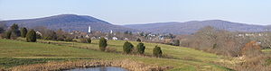
Geography
Attractions in the Frederick area include the Clustered Spires, a monument
Monument
A monument is a type of structure either explicitly created to commemorate a person or important event or which has become important to a social group as a part of their remembrance of historic times or cultural heritage, or simply as an example of historic architecture...
to Francis Scott Key
Francis Scott Key
Francis Scott Key was an American lawyer, author, and amateur poet, from Georgetown, who wrote the lyrics to the United States' national anthem, "The Star-Spangled Banner".-Life:...
, the National Museum of Civil War Medicine
National Museum of Civil War Medicine
The National Museum of Civil War Medicine is a U.S. historic education institution located in Frederick, Maryland. Its focus involves the medical, surgical and nursing practices during the American Civil War .- History :...
, Monocacy National Battlefield
Monocacy National Battlefield
Monocacy National Battlefield is a unit of the National Park Service, the site of the Battle of Monocacy Junction in the American Civil War fought on July 9, 1864. The battlefield straddles the Monocacy River southwest of the city of Frederick, Maryland. The battle, labeled "The Battle That Saved...
and South Mountain
Battle of South Mountain
The Battle of South Mountain was fought September 14, 1862, as part of the Maryland Campaign of the American Civil War. Three pitched battles were fought for possession of three South Mountain passes: Crampton's, Turner's, and Fox's Gaps. Maj. Gen. George B...
battlefields, and the Schifferstadt Architectural Museum.
Adjacent counties
- Adams County, PennsylvaniaAdams County, PennsylvaniaAdams County is a county in the U.S. state of Pennsylvania. As of the 2010 census, the population was 101,407. It was created on January 22, 1800, from part of York County and named in honor of the second President of the United States, John Adams...
(north) - Carroll CountyCarroll County, MarylandCarroll County is a county located in the U.S. state of Maryland. In 2010, its population was 167,134. It was named for Charles Carroll of Carrollton , signer of the American Declaration of Independence. Its county seat is Westminster....
(east) - Howard CountyHoward County, Maryland-2010:Whereas according to the 2010 U.S. Census Bureau:*62.2% White*17.5% Black*0.3% Native American*14.4% Asian*0.0% Native Hawaiian or Pacific Islander*3.6% Two or more races*2.0% Other races*5.8% Hispanic or Latino -2000:...
(southeast) - Franklin County, PennsylvaniaFranklin County, PennsylvaniaAs of the census of 2000, there were 129,313 people, 50,633 households, and 36,405 families residing in the county. The population density was 168 people per square mile . There were 53,803 housing units at an average density of 70 per square mile...
(northwest) - Montgomery CountyMontgomery County, MarylandMontgomery County is a county in the U.S. state of Maryland, situated just to the north of Washington, D.C., and southwest of the city of Baltimore. It is one of the most affluent counties in the United States, and has the highest percentage of residents over 25 years of age who hold post-graduate...
(south) - Washington CountyWashington County, MarylandWashington County is a county located in the western part of the U.S. state of Maryland, bordering southern Pennsylvania to the north, northern Virginia to the south, and the Eastern Panhandle of West Virginia to the south and west. As of the 2010 Census, its population is 147,430...
(west) - Loudoun County, VirginiaLoudoun County, VirginiaLoudoun County is a county located in the Commonwealth of Virginia, and is part of the Washington Metropolitan Area. As of the 2010 U.S. Census, the county is estimated to be home to 312,311 people, an 84 percent increase over the 2000 figure of 169,599. That increase makes the county the fourth...
(southwest)
National protected areas
- Catoctin Mountain ParkCatoctin Mountain ParkCatoctin Mountain Park, located in north-central Maryland, is part of the forested Catoctin Mountain ridge that forms the eastern rampart of the Appalachian Mountains...
- Chesapeake and Ohio Canal National Historical ParkChesapeake and Ohio Canal National Historical ParkThe Chesapeake and Ohio Canal National Historical Park is a United States National Historical Park located in the District of Columbia and the states of Maryland and West Virginia. The park was established as a National Monument in 1961 by President Dwight D...
(part) - Monocacy National BattlefieldMonocacy National BattlefieldMonocacy National Battlefield is a unit of the National Park Service, the site of the Battle of Monocacy Junction in the American Civil War fought on July 9, 1864. The battlefield straddles the Monocacy River southwest of the city of Frederick, Maryland. The battle, labeled "The Battle That Saved...
Major highways
.svg.png) Interstate 70Interstate 70Interstate 70 is an Interstate Highway in the United States that runs from Interstate 15 near Cove Fort, Utah, to a Park and Ride near Baltimore, Maryland. It was the first Interstate Highway project in the United States. I-70 approximately traces the path of U.S. Route 40 east of the Rocky...
Interstate 70Interstate 70Interstate 70 is an Interstate Highway in the United States that runs from Interstate 15 near Cove Fort, Utah, to a Park and Ride near Baltimore, Maryland. It was the first Interstate Highway project in the United States. I-70 approximately traces the path of U.S. Route 40 east of the Rocky....svg.png) Interstate 270Interstate 270 (Maryland)Interstate 270 is a auxiliary Interstate Highway in the U.S. state of Maryland that travels between Interstate 495 just north of Bethesda, Montgomery County and Interstate 70 in the city of Frederick in Frederick County. It consists of the mainline as well as a spur that provides access to and...
Interstate 270Interstate 270 (Maryland)Interstate 270 is a auxiliary Interstate Highway in the U.S. state of Maryland that travels between Interstate 495 just north of Bethesda, Montgomery County and Interstate 70 in the city of Frederick in Frederick County. It consists of the mainline as well as a spur that provides access to and... U.S. Route 15U.S. Route 15U.S. Route 15 is a -long United States highway, designated along South Carolina, North Carolina, Virginia, Maryland, Pennsylvania, and New York. The route is signed north–south, from U.S. Route 17 Alternate in Walterboro, South Carolina to Interstate 86 and NY 17 in Painted Post, New York.US...
 U.S. Route 40U.S. Route 40U.S. Route 40 is an east–west United States highway. As with most routes whose numbers end in a zero, U.S. 40 once traversed the entire United States. It is one of the original 1920s U.S. Highways, and its first termini were San Francisco, California, and Atlantic City, New Jersey...
 U.S. Route 40 Alternate
 U.S. Route 340U.S. Route 340 in MarylandU.S. Route 340 is a part of the U.S. Highway System that runs from Greenville, Virginia to Frederick, Maryland. In Maryland, the U.S. highway runs from the Virginia state line at the Potomac River at Sandy Hook east to its northern terminus at US 15 and US 40 in Frederick...
 Maryland Route 17Maryland Route 17Maryland Route 17 is a state highway in the U.S. state of Maryland. The state highway begins at the Virginia state line at the Potomac River in Brunswick, where the highway continues south as Virginia State Route 287 . MD 17 runs north from the Brunswick Bridge to the Frederick–Washington...
 Maryland Route 26Maryland Route 26Maryland Route 26 is an east–west state highway in the U.S. state of Maryland. Outside of the Baltimore city limits, it is known as Liberty Road; inside the city limits it is known as Liberty Heights Avenue....
 Maryland Route 28Maryland Route 28Maryland Route 28 is a state highway in the U.S. state of Maryland. The state highway runs from U.S. Route 15 in Point of Rocks east to MD 182 in Norwood. The western portion of MD 28 is a rural highway connecting several villages in southern Frederick County and western Montgomery County...
 Maryland Route 31Maryland Route 31Maryland Route 31 is a state highway in the U.S. state of Maryland. Known for most of its length as New Windsor Road, the state highway runs from MD 26 in Libertytown east to MD 140 in Westminster. MD 31 connects the county seats of Frederick and Westminster via Libertytown in eastern Frederick...
 Maryland Route 75Maryland Route 75Maryland Route 75 is a state highway in the U.S. state of Maryland. Known for most of its length as Green Valley Road, the state highway runs from MD 355 near Hyattstown north to MD 31 in New Windsor...
 Maryland Route 76Maryland Route 76Maryland Route 76 is a state highway in the U.S. state of Maryland. Known as Motters Station Road, the state highway runs from MD 77 in Rocky Ridge north to U.S. Route 15 near Emmitsburg in northern Frederick County...
 Maryland Route 77Maryland Route 77Maryland Route 77 is a state highway in the U.S. state of Maryland. The state highway runs from MD 64 in Smithsburg east to MD 194 in Keymar. MD 77 is the main east–west highway of northern Frederick County...
 Maryland Route 79Maryland Route 79Maryland Route 79 is a state highway in the U.S. state of Maryland. Known as Petersville Road, the state highway runs from MD 17 and MD 464 in Rosemont north to MD 180 in Petersville. MD 79 and the adjacent portion of MD 17 south to Brunswick were constructed in 1916...
 Maryland Route 80Maryland Route 80Maryland Route 80 is a state highway in the southern part of Frederick County in the U.S. state of Maryland. Towards its eastern terminus at MD 27, the highway briefly enters Montgomery County as well.-Counties traversed:*Frederick County*Montgomery County...
 Maryland Route 85Maryland Route 85Maryland Route 85 is a state highway in the U.S. state of Maryland. Known as Buckeystown Pike, the state highway runs from MD 28 in Tuscarora north to the Frederick city limit north of Interstate 70 , where the highway continues north as East Street. MD 85 connects Tuscarora and Buckeystown in...
 Maryland Route 180Maryland Route 180Maryland Route 180 is a state highway in the U.S. state of Maryland. Known for most of its length as Jefferson Pike, the state highway runs from U.S. Route 340 in Knoxville east to MD 351 and Interstate 70 in Frederick. MD 180 is the old alignment of US 340 through Knoxville, Petersville, and...
 Maryland Route 194Maryland Route 194Maryland Route 194 is a state highway in the U.S. state of Maryland. The state highway runs from MD 26 in Ceresville north to the Pennsylvania state line near Taneytown, where the highway continues as Pennsylvania Route 194 toward Hanover...
 Maryland Route 351Maryland Route 351Maryland Route 351 is a state highway in the U.S. state of Maryland. Known as Ballenger Creek Pike, the state highway runs from the beginning of state maintenance near Adamstown north to MD 180 and Interstate 70 in Frederick. MD 351 connects Frederick with its suburb of Ballenger Creek and the...
 Maryland Route 355Maryland Route 355Maryland Route 355 is a north–south road in western central Maryland in the United States. The southern terminus of the route is at the Washington, D.C. border in Friendship Heights, Montgomery County, where it continues south as Wisconsin Avenue into Washington. The northern terminus is...
 Maryland Route 550Maryland Route 550Maryland Route 550 is a state highway in the U.S. state of Maryland. The state highway runs from MD 26 in Libertytown north to Pen Mar Road in Fort Ritchie...
Demographics
| > | Year | Population |
|---|---|
| 1790 | 30,791 |
| 1800 | 31,523 |
| 1810 | 34,437 |
| 1820 | 40,459 |
| 1830 | 45,789 |
| 1840 | 36,405 |
| 1850 | 40,987 |
| 1860 | 46,591 |
| 1870 | 47,572 |
| 1880 | 50,482 |
| 1890 | 49,512 |
2010
Whereas according to the 2010 U.S. Census Bureau:- 81.5% WhiteWhite AmericanWhite Americans are people of the United States who are considered or consider themselves White. The United States Census Bureau defines White people as those "having origins in any of the original peoples of Europe, the Middle East, or North Africa...
- 8.6% BlackAfrican AmericanAfrican Americans are citizens or residents of the United States who have at least partial ancestry from any of the native populations of Sub-Saharan Africa and are the direct descendants of enslaved Africans within the boundaries of the present United States...
- 0.3% Native AmericanNative Americans in the United StatesNative Americans in the United States are the indigenous peoples in North America within the boundaries of the present-day continental United States, parts of Alaska, and the island state of Hawaii. They are composed of numerous, distinct tribes, states, and ethnic groups, many of which survive as...
- 3.8% AsianAsian AmericanAsian Americans are Americans of Asian descent. The U.S. Census Bureau definition of Asians as "Asian” refers to a person having origins in any of the original peoples of the Far East, Southeast Asia, or the Indian subcontinent, including, for example, Cambodia, China, India, Indonesia, Japan,...
- 0.0% Native Hawaiian or Pacific IslanderPacific Islander AmericanPacific Islander Americans, also known as Oceanian Americans, are residents of the United States with original ancestry from Oceania. They represent the smallest racial group counted in the United States census of 2000. They numbered 874,000 people or 0.3 percent of the United States population...
- 2.8% Two or more racesMultiracial AmericanMultiracial Americans, US residents who identify themselves as of "two or more races", were numbered at around 9 million, or 2.9% of the population, in the census of 2010. However there is considerable evidence that the real number is far higher. Prior to the mid-20th century many people hid their...
- 3.0% Other racesRace (United States Census)Race and ethnicity in the United States Census, as defined by the Federal Office of Management and Budget and the United States Census Bureau, are self-identification data items in which residents choose the race or races with which they most closely identify, and indicate whether or not they are...
- 7.3% Hispanic or LatinoHispanic and Latino AmericansHispanic or Latino Americans are Americans with origins in the Hispanic countries of Latin America or in Spain, and in general all persons in the United States who self-identify as Hispanic or Latino.1990 Census of Population and Housing: A self-designated classification for people whose origins...
(of any race)
2000
There were 84,800 households out of which 37.6% had children under the age of 18 living with them, 57.8% were married couples living together, 10.0% had a female householder with no husband present, and 27.8% were non-families. 22.0% of all households were made up of individuals and 7.8% had someone living alone who was 65 years of age or older. The average household size was 2.70 and the average family size was 3.17.In the county the population was spread out with 25.3% under the age of 18, 8.4% from 18 to 24, 26.7% from 25 to 44, 28.6% from 45 to 64, and 11.1% who were 65 years of age or older. The median age was 38.6 years. For every 100 females there were 96.85 males. For every 100 females age 18 and over, there were 94.02 males.
Economy
The median income for a household in Frederick county is $60,276, and the median income for a family was $67,879. Males had a median income of $42,378 versus $30,564 for females. The per capita incomePer capita income
Per capita income or income per person is a measure of mean income within an economic aggregate, such as a country or city. It is calculated by taking a measure of all sources of income in the aggregate and dividing it by the total population...
for the county was $25,404. About 2.90% of families and 4.50% of the population were below the poverty line, including 4.90% of those under age 18 and 6.00% of those age 65 or over.
Fort Detrick
Fort Detrick
Fort Detrick is a U.S. Army Medical Command installation located in Frederick, Maryland, USA. Historically, Fort Detrick was the center for the United States' biological weapons program ....
is the largest employer in Frederick County. The largest employers aside from the government are the Frederick Memorial Healthcare System, Bechtel
Bechtel
Bechtel Corporation is the largest engineering company in the United States, ranking as the 5th-largest privately owned company in the U.S...
, SAIC
Science Applications International Corporation
SAIC is a FORTUNE 500 scientific, engineering and technology applications company headquartered in the United States with numerous federal, state, and private sector clients...
and Wells Fargo
Wells Fargo
Wells Fargo & Company is an American multinational diversified financial services company with operations around the world. Wells Fargo is the fourth largest bank in the U.S. by assets and the largest bank by market capitalization. Wells Fargo is the second largest bank in deposits, home...
. Frederick County has a strong agricultural
Agriculture
Agriculture is the cultivation of animals, plants, fungi and other life forms for food, fiber, and other products used to sustain life. Agriculture was the key implement in the rise of sedentary human civilization, whereby farming of domesticated species created food surpluses that nurtured the...
component of its economy, and it is the largest producer of milk
Milk
Milk is a white liquid produced by the mammary glands of mammals. It is the primary source of nutrition for young mammals before they are able to digest other types of food. Early-lactation milk contains colostrum, which carries the mother's antibodies to the baby and can reduce the risk of many...
in Maryland.
Communities
Census
A census is the procedure of systematically acquiring and recording information about the members of a given population. It is a regularly occurring and official count of a particular population. The term is used mostly in connection with national population and housing censuses; other common...
of 2010, there were 233,385 people, 84,800 households, and 61,198 families residing in the county. The population density
Population density
Population density is a measurement of population per unit area or unit volume. It is frequently applied to living organisms, and particularly to humans...
was 295 people per square mile (114/km²). There were 90,136 housing units at an average density of 110/square mile (43/km²). The racial makeup of the county was 81.5% White
Race (United States Census)
Race and ethnicity in the United States Census, as defined by the Federal Office of Management and Budget and the United States Census Bureau, are self-identification data items in which residents choose the race or races with which they most closely identify, and indicate whether or not they are...
, 8.6% Black
Race (United States Census)
Race and ethnicity in the United States Census, as defined by the Federal Office of Management and Budget and the United States Census Bureau, are self-identification data items in which residents choose the race or races with which they most closely identify, and indicate whether or not they are...
or African American
Race (United States Census)
Race and ethnicity in the United States Census, as defined by the Federal Office of Management and Budget and the United States Census Bureau, are self-identification data items in which residents choose the race or races with which they most closely identify, and indicate whether or not they are...
, 0.3% Native American
Race (United States Census)
Race and ethnicity in the United States Census, as defined by the Federal Office of Management and Budget and the United States Census Bureau, are self-identification data items in which residents choose the race or races with which they most closely identify, and indicate whether or not they are...
, 3.8% Asian
Race (United States Census)
Race and ethnicity in the United States Census, as defined by the Federal Office of Management and Budget and the United States Census Bureau, are self-identification data items in which residents choose the race or races with which they most closely identify, and indicate whether or not they are...
, 0.045% Pacific Islander
Race (United States Census)
Race and ethnicity in the United States Census, as defined by the Federal Office of Management and Budget and the United States Census Bureau, are self-identification data items in which residents choose the race or races with which they most closely identify, and indicate whether or not they are...
, 2.9% from other races
Race (United States Census)
Race and ethnicity in the United States Census, as defined by the Federal Office of Management and Budget and the United States Census Bureau, are self-identification data items in which residents choose the race or races with which they most closely identify, and indicate whether or not they are...
, and 2.8% from two or more races. 7.3% of the population were Hispanic
Race (United States Census)
Race and ethnicity in the United States Census, as defined by the Federal Office of Management and Budget and the United States Census Bureau, are self-identification data items in which residents choose the race or races with which they most closely identify, and indicate whether or not they are...
or Latino
Race (United States Census)
Race and ethnicity in the United States Census, as defined by the Federal Office of Management and Budget and the United States Census Bureau, are self-identification data items in which residents choose the race or races with which they most closely identify, and indicate whether or not they are...
of any race. According to Census 2000 24.7% were of German, 12.9% American, 12.3% Irish
Irish people
The Irish people are an ethnic group who originate in Ireland, an island in northwestern Europe. Ireland has been populated for around 9,000 years , with the Irish people's earliest ancestors recorded having legends of being descended from groups such as the Nemedians, Fomorians, Fir Bolg, Tuatha...
and 10.1% English
English people
The English are a nation and ethnic group native to England, who speak English. The English identity is of early mediaeval origin, when they were known in Old English as the Anglecynn. England is now a country of the United Kingdom, and the majority of English people in England are British Citizens...
ancestry.
- 2 cities:
- BrunswickBrunswick, MarylandBrunswick is a city in Frederick County, Maryland, United States. The population was 5,870 at the 2010 census.- History :The area now known as Brunswick was originally home to the Susquehanna Indians. In 1728 the first settlement was built, and the region became known as Eel Town, because the...
(incorporated 1890) - FrederickFrederick, MarylandFrederick is a city in north-central Maryland. It is the county seat of Frederick County, the largest county by area in the state of Maryland. Frederick is an outlying community of the Washington-Arlington-Alexandria, DC-VA-MD-WV Metropolitan Statistical Area, which is part of a greater...
(incorporated 1816)
- Brunswick
- 9 towns:
- BurkittsvilleBurkittsville, MarylandBurkittsville is a town in Frederick County, Maryland, United States. The population was 171 at the 2000 census.-Geography:Burkittsville is located at ....
(incorporated 1894) - EmmitsburgEmmitsburg, Maryland-Demographics:As of the census of 2000, there were 2,290 people, 811 households, and 553 families residing in the town. The population density was 1,992.9 people per square mile . There were 862 housing units at an average density of 750.2 per square mile...
(incorporated 1824) - MiddletownMiddletown, MarylandMiddletown is a town in Frederick County, Maryland, United States. The population was 2,668 at the 2000 census. Middletown is a small, rural community steeped in American history...
(incorporated 1833) - Mount AiryMount Airy, MarylandMount Airy is a town in Carroll, Frederick, Howard, and Montgomery counties in the U.S. state of Maryland.-Geography:According to the United States Census Bureau, the town has a total area of , all of it land.-History:...
(This town is partly in Frederick County and partly in Carroll CountyCarroll County, MarylandCarroll County is a county located in the U.S. state of Maryland. In 2010, its population was 167,134. It was named for Charles Carroll of Carrollton , signer of the American Declaration of Independence. Its county seat is Westminster....
.) (incorporated 1894) - MyersvilleMyersville, MarylandMyersville is a town in Frederick County, Maryland, United States. The population was 1,382 at the 2000 census.-History:The Peter of P. Grossnickel Farm was listed on the National Register of Historic Places in 1998.-Geography:...
(incorporated 1904) - New MarketNew Market, MarylandNew Market is a town in Frederick County, Maryland, United States. The population was 427 at the 2000 census. The town bills itself as the "Antiques capital of Maryland".-Geography:New Market is located at ....
(incorporated 1878) - ThurmontThurmont, MarylandThurmont is a town in Frederick County, Maryland, United States. The population was 5,588 at the 2000 census. The town is located in the northern part of Frederick County , approximately ten miles from the Pennsylvania border, along U.S. Highway 15...
(incorporated 1831) - WalkersvilleWalkersville, MarylandWalkersville is a town in Frederick County, Maryland, United States. The population was 5,805 per the 2010 census.-History:Crum Road Bridge was listed on the National Register of Historic Places in 1978...
(incorporated 1892) - WoodsboroWoodsboro, MarylandWoodsboro is a town in Frederick County, Maryland, United States that was granted to Joseph Wood in 1693. The population was 846 at the 2000 census.-History:...
(incorporated 1836)
- Burkittsville
- 1 VillageVillageA village is a clustered human settlement or community, larger than a hamlet with the population ranging from a few hundred to a few thousand , Though often located in rural areas, the term urban village is also applied to certain urban neighbourhoods, such as the West Village in Manhattan, New...
:- RosemontRosemont, MarylandRosemont is a village in Frederick County, Maryland, United States. The population was 273 at the 2000 census.-Geography:Rosemont is located at ....
(incorporated 1953)
- Rosemont
Unincorporated areas are also considered as towns by many people and listed in many collections of towns, but they lack local government. Various organizations, such as the United States Census Bureau
United States Census Bureau
The United States Census Bureau is the government agency that is responsible for the United States Census. It also gathers other national demographic and economic data...
, the United States Postal Service
United States Postal Service
The United States Postal Service is an independent agency of the United States government responsible for providing postal service in the United States...
, and local chambers of commerce, define the communities they wish to recognize differently, and since they are not incorporated, their boundaries have no official status outside the organizations in question. The Census Bureau recognizes the following census-designated place
Census-designated place
A census-designated place is a concentration of population identified by the United States Census Bureau for statistical purposes. CDPs are delineated for each decennial census as the statistical counterparts of incorporated places such as cities, towns and villages...
s in the county:
- Ballenger CreekBallenger Creek, MarylandBallenger Creek is a census-designated place in Frederick County, Maryland, United States. It is a part of the Frederick, Maryland urban area that is adjacent to Frederick's City limit on the South, with a 2010 Census population of 18,274...
- Braddock HeightsBraddock Heights, MarylandBraddock Heights is a census-designated place in Frederick County, Maryland, United States. The population was 4,627 at the 2000 census. Braddock Heights is part of the Middletown, Maryland School District...
- Clover HillClover Hill, MarylandClover Hill is a census-designated place in Frederick County, Maryland, United States. The population was 3,260 at the 2000 census.-Geography:Clover Hill is located at ....
- Discovery-Spring GardenDiscovery-Spring Garden, MarylandDiscovery-Spring Garden is a census-designated place in Frederick County, Maryland, United States. It is the combination of the two communities of Discovery and Spring Garden...
(a combination of the communities of Discovery and Spring Garden recognized as a unit by the Census Bureau) - Green ValleyGreen Valley, MarylandGreen Valley is a census-designated place in southern Frederick County, Maryland, United States. The population was 12,262 at the 2000 census.-Geography:Green Valley is located at ....
- Linganore-BartonsvilleLinganore-Bartonsville, MarylandLinganore-Bartonsville is a census-designated place in Frederick County, Maryland, United States which is primarily the Spring Ridge subdivision and surrounding residential area...
(a combination of the communities of Linganore and Bartonsville recognized as a unit by the Census Bureau)
Other unincorporated areas include:
- AdamstownAdamstown, MarylandAdamstown is an unincorporated community located in Frederick County, Maryland, USA. It is named for Adam Kohlenberg , a station agent and first town merchant who owned much of present-day Adamstown.- Events :...
- BuckeystownBuckeystown, MarylandBuckeystown is an unincorporated community in Frederick County, Maryland, United States. Buckeystown Historic District and Buckingham House and Industrial School Complex were listed on the National Register of Historic Places in 1982. Carrollton Manor was listed in 1997.Current member of Congress...
- GracehamGraceham, MarylandGraceham is an unincorporated community in Frederick County, Maryland, United States. Graceham is home to Graceham Moravian Church and Parsonage.-References:...
- IjamsvilleIjamsville, MarylandIjamsville is an unincorporated community located 7 miles southeast of Frederick, Maryland, in Frederick County, Maryland, United States.In 1785, a gentleman by the name of Plummer Ijams became the first recorded resident of what would become Ijamsville. Plummer Ijams died on June 14, 1796...
- JeffersonJefferson, MarylandJefferson is an unincorporated community located in Frederick County, Maryland, established in 1774, incorporated as a town in 1831. However, a year later, in 1832, the citizens of the town decided that municipal government was unnecessary, thus, it was disincorporated.- History of Jefferson...
- KnoxvilleKnoxville, MarylandKnoxville is an unincorporated community in Washington County, Maryland, United States.-References:...
- LadiesburgLadiesburg, MarylandLadiesburg is an unincorporated community in Frederick County, Maryland, United States.-References:...
- Lewistown
- LibertytownLibertytown, MarylandLibertytown is an unincorporated community in Frederick County, Maryland, United States. The Abraham Jones House was listed on the National Register of Historic Places in 1973.-References:...
- Lake LinganoreLake Linganore, MarylandLake Linganore is an unincorporated community in Frederick County, Maryland, United States.The community consists of "villages", essentially neighborhoods, centered around a system of lakes man-made lakes, the centerpiece of which is Lake Linganore...
- MonroviaMonrovia, MarylandMonrovia is a small unincorporated area located in the southeastern portion of Frederick County. The zip code for the area is 21770, and its coordinates are .- Education :Monrovia is a part of the Frederick County public school system...
- New MidwayNew Midway, MarylandNew Midway is an unincorporated community in Frederick County, Maryland, United States.-References:...
- Petersville
- Point of RocksPoint of Rocks, MarylandPoint of Rocks is a community in Frederick County, Maryland. It is named for the striking rock formation on the adjacent Catoctin Mountain, which were formed by the Potomac River cutting through the ridge in a water gap, a typical formation in the Ridge-and-Valley Appalachians...
- Rocky RidgeRocky Ridge, MarylandRocky Ridge is an unincorporated community in Frederick County, Maryland, United States. Old Mill Road Bridge was listed on the National Register of Historic Places in 1979.-External links:*...
- SabillasvilleSabillasville, MarylandSabillasville is an unincorporated community in Frederick County, Maryland, United States. Victor Cullen School Power House was listed on the National Register of Historic Places in 1987 and the Victor Cullen Center, Old Administration Building was listed in 1990.-References:...
- Sunny SideSunny Side, MarylandSunny Side is an unincorporated village in south-western Frederick County, Maryland. The village runs between U.S. Route 15 and U.S. Route 340 between Jefferson and Adamstown. Sunny Side is noted by the Sunny Side United Methodist Church....
- TuscaroraTuscarora, MarylandTuscarora is a small village in southern Frederick County, Maryland. Maryland Route 28 runs through the village. The community was named for Tuscarora Creek that runs in the area. There is an old, small post office that is in the area along Route 28. The area was formerly named Licksville after...
- UrbanaUrbana, MarylandUrbana is an unincorporated community located in southern Frederick County, Maryland. It lies at the I-270/MD 80 interchange, about southeast of Frederick.-History:The Urbana area was first settled in 1730....
- Utica
- WolfsvilleWolfsville, MarylandWolfsville is an unincorporated community in Frederick County, Maryland, United States.-References:...