

U.S. Route 15
Encyclopedia
U.S. Route 15 is a 791.71 mi (1,274.13 km)-long United States highway, designated along South Carolina
, North Carolina
, Virginia
, Maryland
, Pennsylvania
, and New York
. The route is signed north–south, from U.S. Route 17 Alternate
in Walterboro, South Carolina
to Interstate 86
and NY 17
in Painted Post, New York
.
US 15 is one of the original United States Highways from 1926.
|SC
|158.58
|255.210
|-
|NC
|158.13
|254.48
|-
|VA
|229.73
|369.71
|-
|MD
|37.92
|61.02
|-
|PA
|194.89
|313.64
|-
|NY
|12.46
|20.05
|-
|Total
|791.71
|1274.13
|}
in Walterboro
US 15 goes east. It runs parallel to I-95
and across I-26
. Then it turns north and crosses I-95
. Just before the town of Santee
US 15 converges with US 301
. In Santee the two highways merge with I-95
at exit 98 and all three cross Lake Marion
. At exit 102, US 15/301 split off from I-95
and go into the town of Summerton
. US 15 then separates from US 301 and heads mainly north to city of Sumter
. From there it continues north, crosses I-20
, goes through the cities of Bishopville
and Hartsville
to the town of Society Hill
. It is here that US 401
joins US 15 and both go to the North Carolina border.
US 15-401 continues to Laurinburg
, at which US 401 splits off and US 15 runs concurrent with US 501
. US 1 briefly merges with US 15-501 through Aberdeen
and Sanford
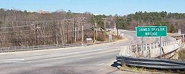
. The route continues north of Sanford with NC 87 towards Pittsboro
. Past Pittsboro, US 15-501 goes toward Chapel Hill
and skirts around the southeastern edge of the city and then across I-40
to Durham
. Here US 15-501 splits into Business and Bypass routes. Before US 15 Business and Bypass highways rejoin on the other side of Durham, I-85
merges into US 15 Business. Then I-85/US 15 go north. Right after crossing Falls Lake at exit 186, US 15 splits off to the east. US 15 runs parallel to I-85, going through the city of Creedmoor
. It then crosses back over I-85, goes through the city of Oxford
towards the N.C.-Virginia state line.
. Not far from the state line, it crosses a narrow finger of the John H. Kerr Reservoir
. The highway goes through the town of Clarksville
and merges very briefly with US 58
/VA 49
and then crosses over the main body of Lake Kerr. US 15 continues a little ways and merges with US 360
. The two highways go on to the town of Keysville
. After Keysville, US 15 branches off and goes to the town of Farmville
. After a brief merge with US 460
, US 15 goes through the towns of Dillwyn
, New Canton on the James River
and Palmyra
before crossing I-64
. After passing the interstate, US 15 goes through the towns of Gordonsville
(with a quick merge with US 33
) and Orange VA
and then on to Culpeper
. After Culpeper US 15 runs concurrent with US 29
. In Warrenton
they briefly merge with US 17
. South of Gainesville
US 15 breaks off and crosses I-66
. From there it goes on to Leesburg
and then to the state line.
, crossing the Potomac River
and then merges into US 340
just south of Frederick
. In Frederick, US 40
merges with US 15 for a very short distance. From there US 15 goes through Thurmont
and on to the MD/PA border.
south of Gettysburg
. Business Route 15 (Emmitsburg Road) goes through Gettysburg, while US 15 bypasses the borough; the bypass continues to York Springs
. US 15 passes through Dillsburg
before becoming a highway near Grantham
and the Messiah College
campus.
US 15 continues as a highway until it intersects U.S. Route 11
and Pennsylvania Route 581 in Camp Hill
. US 15 runs concurrent with US 11, passing Harrisburg on the west shore of the Susquehanna River
. The concurrency ends at Shamokin Dam
, where US 11 splits and follows the North Branch Susquehanna River, and US 15 follows the West Branch Susquehanna River
north towards Williamsport where it passes through Lewisburg and the campus of Bucknell University
(which is partially bisected by the highway). In the future, US 15 and US 11 will diverge in Selinsgrove, PA, from which US 15 will proceed north on a road yet to be built, and connect back to its current alignment near Winfield, PA. 11 will be joined to a business spur of 15 instead of the main route.
 The segment from Williamsport, Pennsylvania
to the northern terminus at I-86
and NY 17 in Painted Post, New York
has been completely upgraded to Interstate standards and runs along with newly redesignated I-99. From Lindley
to Presho, New York, construction on the final limited-access stretch between Williamsport and I-86 is expected to begin in 2010. The 12.59 miles (20.3 km) segment of US 15 in New York
runs parallel to the Tioga River
from the state line to its current northern terminus at I-86 and NY 17 exit 44 at the junction of the Tioga and Cohocton
rivers in Painted Post, west of downtown Corning
. The interchange of US 15 and I-86 has been upgraded to meet Interstate standards.
in downtown Painted Post, US 15 turned north onto NY 415. At the northern terminus of NY 415, located at NY 15
and New York State Route 21
south of Wayland
, US 15 followed the current routing of NY 15 into downtown Rochester, where it terminated at New York State Route 31
.
US 15 has shed considerable length in near-continuous realignment and regrading
over the years. Prior to the completion of the Tioga Creek flood-control project, hastened by the flooding caused after Hurricane Agnes
along the Pennsylvania and New York segments of US 15 in June, 1972, US 15 passed through many small towns in Pennsylvania as it passed from Lawrenceville, at the New York border, to West Milton, where the road begins to follow the west bank of the Susquehanna River
. Originally a winding two-lane road over numerous mountains, 15 now bypasses many small towns such as Sebring, Blossburg, Covington, Canoe Camp and Hepburnville. In the 1970s, the challenging two-lane alignment was expanded in some areas to four lanes by building a second set of lanes. Now, for some streches, the "old" road is the northbound side and in other sections, the southbound side.
 Near Mansfield, Pennsylvania
the old Route 15 alignment is now a 2.5 miles (4 km) access road leading to a boat ramp, built where the old road now disappears into the Tioga Reservoir. Near Tioga, Pennsylvania, drivers crossing the tall concrete bridge can see where a two-lane road (formerly Route 15), still marked with double-yellow lines, disappears into the water.
South Carolina
South Carolina is a state in the Deep South of the United States that borders Georgia to the south, North Carolina to the north, and the Atlantic Ocean to the east. Originally part of the Province of Carolina, the Province of South Carolina was one of the 13 colonies that declared independence...
, North Carolina
North Carolina
North Carolina is a state located in the southeastern United States. The state borders South Carolina and Georgia to the south, Tennessee to the west and Virginia to the north. North Carolina contains 100 counties. Its capital is Raleigh, and its largest city is Charlotte...
, Virginia
Virginia
The Commonwealth of Virginia , is a U.S. state on the Atlantic Coast of the Southern United States. Virginia is nicknamed the "Old Dominion" and sometimes the "Mother of Presidents" after the eight U.S. presidents born there...
, Maryland
Maryland
Maryland is a U.S. state located in the Mid Atlantic region of the United States, bordering Virginia, West Virginia, and the District of Columbia to its south and west; Pennsylvania to its north; and Delaware to its east...
, Pennsylvania
Pennsylvania
The Commonwealth of Pennsylvania is a U.S. state that is located in the Northeastern and Mid-Atlantic regions of the United States. The state borders Delaware and Maryland to the south, West Virginia to the southwest, Ohio to the west, New York and Ontario, Canada, to the north, and New Jersey to...
, and New York
New York
New York is a state in the Northeastern region of the United States. It is the nation's third most populous state. New York is bordered by New Jersey and Pennsylvania to the south, and by Connecticut, Massachusetts and Vermont to the east...
. The route is signed north–south, from U.S. Route 17 Alternate
U.S. Route 17 Alternate (South Carolina)
U.S. Route 17 Alternate is an alternate route of U.S. Route 17 in South Carolina that runs between Pocotaligo and Georgetown. It is long and has been four-laned in various segments since 1970.-Route description:...
in Walterboro, South Carolina
Walterboro, South Carolina
Walterboro is a city in Colleton County, South Carolina, United States. The population was 5,153 at the 2000 census . It is the county seat of Colleton County.-History:...
to Interstate 86
Interstate 86 (east)
Interstate 86 is an Interstate Highway that extends for through northwestern Pennsylvania and southern New York in the United States...
and NY 17
New York State Route 17
New York State Route 17 is a state highway that extends for through the Southern Tier and Downstate regions of New York in the United States...
in Painted Post, New York
Painted Post, New York
Painted Post is a village in Steuben County, New York, United States. The village is in the town of Erwin, west of the city of Corning. The population was 1,842 at the 2000 census. The name comes from a painted and carved post found by explorers at the junction of three local rivers...
.
US 15 is one of the original United States Highways from 1926.
Route description
|-|SC
|158.58
|255.210
|-
|NC
|158.13
|254.48
|-
|VA
U.S. Route 15 in Virginia
U.S. Route 15 is a part of the U.S. Highway System that runs from Walterboro, South Carolina to Painted Post, New York. In Virginia, the U.S. Highway runs from the North Carolina state line near Clarksville north to the Maryland state line at the Potomac River near Lucketts...
|229.73
|369.71
|-
|MD
U.S. Route 15 in Maryland
U.S. Route 15 is a part of the U.S. Highway System that runs from Walterboro, South Carolina to Painted Post, New York. In Maryland, the highway runs from the Virginia state line at the Potomac River in Point of Rocks north to the Pennsylvania state line near Emmitsburg. US 15 is...
|37.92
|61.02
|-
|PA
U.S. Route 15 in Pennsylvania
U.S. Route 15 is a north-south U.S. Highway in Pennsylvania.-Route description:US 15 enters Pennsylvania south of Gettysburg, Adams County. The route heads to the north toward Harrisburg. It joins with U.S. 11 going along the west shore of the Susquehanna River until they split across the river...
|194.89
|313.64
|-
|NY
U.S. Route 15 in New York
U.S. Route 15 is a part of the U.S. Highway System that runs from Walterboro, South Carolina, to Painted Post, New York. In the U.S. state of New York, US 15 extends through the Southern Tier from the Pennsylvania state line at Lindley north to an interchange with the Southern Tier...
|12.46
|20.05
|-
|Total
|791.71
|1274.13
|}
South Carolina
Starting at ALT US 17U.S. Route 17 Alternate (South Carolina)
U.S. Route 17 Alternate is an alternate route of U.S. Route 17 in South Carolina that runs between Pocotaligo and Georgetown. It is long and has been four-laned in various segments since 1970.-Route description:...
in Walterboro
Walterboro, South Carolina
Walterboro is a city in Colleton County, South Carolina, United States. The population was 5,153 at the 2000 census . It is the county seat of Colleton County.-History:...
US 15 goes east. It runs parallel to I-95
Interstate 95 in South Carolina
Interstate 95 is a major Interstate Highway, running along the East Coast of the United States from Florida to Maine. In South Carolina, I-95 runs approximately parallel to the Atlantic Ocean shore although about inland, from Hardeeville in the south to Dillon in the northeast.-Route...
and across I-26
Interstate 26 in South Carolina
Interstate 26 is a South Carolina Interstate highway running generally east–west to U.S. Route 17 in the Atlantic Coast at Charleston, South Carolina to Landrum in Spartanburg County.-Route description:...
. Then it turns north and crosses I-95
Interstate 95 in South Carolina
Interstate 95 is a major Interstate Highway, running along the East Coast of the United States from Florida to Maine. In South Carolina, I-95 runs approximately parallel to the Atlantic Ocean shore although about inland, from Hardeeville in the south to Dillon in the northeast.-Route...
. Just before the town of Santee
Santee, South Carolina
Santee is a town in Orangeburg County along the Santee River Valley in central South Carolina of the United States. It has become a resort town of note located centrally north-south along the Atlantic Seaboard of South Carolina...
US 15 converges with US 301
U.S. Route 301
U.S. Route 301 is a spur of U.S. Route 1 running through the South Atlantic States. It currently runs 1,099 miles from Glasgow, Delaware at U.S. Route 40 to Sarasota, Florida. It passes through the states of Delaware, Maryland, Virginia, North Carolina, South Carolina, Georgia, and Florida...
. In Santee the two highways merge with I-95
Interstate 95 in South Carolina
Interstate 95 is a major Interstate Highway, running along the East Coast of the United States from Florida to Maine. In South Carolina, I-95 runs approximately parallel to the Atlantic Ocean shore although about inland, from Hardeeville in the south to Dillon in the northeast.-Route...
at exit 98 and all three cross Lake Marion
Lake Marion (South Carolina)
Lake Marion is the largest lake in South Carolina, centrally located and with territory within five counties. The lake is referred to as South Carolina's inland sea. It has a shoreline and covers nearly 110,000 acres of rolling farmlands, former marshes, and river valley landscape...
. At exit 102, US 15/301 split off from I-95
Interstate 95 in South Carolina
Interstate 95 is a major Interstate Highway, running along the East Coast of the United States from Florida to Maine. In South Carolina, I-95 runs approximately parallel to the Atlantic Ocean shore although about inland, from Hardeeville in the south to Dillon in the northeast.-Route...
and go into the town of Summerton
Summerton, South Carolina
Summerton is a town in Clarendon County, South Carolina, in the United States. The population was 1,061 at the 2000 census.-Geography:Summerton is at ....
. US 15 then separates from US 301 and heads mainly north to city of Sumter
Sumter, South Carolina
-Demographics:, there were 59,180 people, 34,717 households, and 4,049 families living in the city. The population density was 4,469.5 people per square mile . There were 416,032 housing units at an average density of 603.0 per square mile...
. From there it continues north, crosses I-20
Interstate 20 in South Carolina
Interstate 20 is a major thoroughfare cutting across the state of South Carolina, linking the state with important transportation and business hubs to the north, west and south, including Atlanta, Georgia, Charlotte, North Carolina , Savannah, Georgia and Washington, D.C...
, goes through the cities of Bishopville
Bishopville, South Carolina
Bishopville is a city in Lee County, South Carolina, United States. The population was 3,670 at the 2000 census. It is the county seat of Lee County.-Geography:Bishopville is located at ....
and Hartsville
Hartsville, South Carolina
Hartsville is a small city in Darlington County, South Carolina, United States. The population was 7,764 at the 2010 census.-Geography:Hartsville is located at ....
to the town of Society Hill
Society Hill, South Carolina
Society Hill is a town in Darlington County, South Carolina, United States. The population was 700 at the 2000 census. It is part of the Florence Metropolitan Statistical Area...
. It is here that US 401
U.S. Route 401
U.S. Route 401 is an north–south United States highway, a spur of U.S. Route 1, that traverses along the fall line from Sumter, South Carolina to Interstate 85 near Wise, North Carolina.-Route description:...
joins US 15 and both go to the North Carolina border.
North Carolina
US 15-401 continues to Laurinburg
Laurinburg, North Carolina
Laurinburg is a mid-sized city in Scotland County, North Carolina, United States. It is the county seat of Scotland County. Located in southern North Carolina near the South Carolina state border, Laurinburg is southwest of Fayetteville and is home to St. Andrews Presbyterian College...
, at which US 401 splits off and US 15 runs concurrent with US 501
U.S. Route 501
-North Carolina business loops:-Virginia business loop:-External links:*...
. US 1 briefly merges with US 15-501 through Aberdeen
Aberdeen, North Carolina
Aberdeen is a town in Moore County, North Carolina, United States. The population was 3,400 at the 2000 census.-Geography:Aberdeen is located at ....
and Sanford
Sanford, North Carolina
Sanford is a city in Lee County, North Carolina, United States. The population was 23,220 at the 2000 census. It is the county seat of Lee County.-Geography:Sanford is located at ....
. The route continues north of Sanford with NC 87 towards Pittsboro
Pittsboro, North Carolina
Pittsboro, North Carolina is a town located in Chatham County, 34 miles southwest of Raleigh, 47 miles southeast of Greensboro, and 17 miles south of Chapel Hill. The population was 3,743 at the 2010 census. It is the county seat of Chatham County....
. Past Pittsboro, US 15-501 goes toward Chapel Hill
Chapel Hill, North Carolina
Chapel Hill is a town in Orange County, North Carolina, United States and the home of the University of North Carolina at Chapel Hill and UNC Health Care...
and skirts around the southeastern edge of the city and then across I-40
Interstate 40 in North Carolina
Interstate 40 runs through the state of North Carolina from the Tennessee state line in the west to its eastern terminus in Wilmington.-Pigeon River Gorge:...
to Durham
Durham, North Carolina
Durham is a city in the U.S. state of North Carolina. It is the county seat of Durham County and also extends into Wake County. It is the fifth-largest city in the state, and the 85th-largest in the United States by population, with 228,330 residents as of the 2010 United States census...
. Here US 15-501 splits into Business and Bypass routes. Before US 15 Business and Bypass highways rejoin on the other side of Durham, I-85
Interstate 85 in North Carolina
In the U.S. state of North Carolina, Interstate 85 scales the state for from the South Carolina border to the Virginia border. As the second-longest interstate in the state , it provides an important link between the cities of Atlanta, Georgia, Charlotte, Greensboro, Richmond, Virginia and...
merges into US 15 Business. Then I-85/US 15 go north. Right after crossing Falls Lake at exit 186, US 15 splits off to the east. US 15 runs parallel to I-85, going through the city of Creedmoor
Creedmoor, North Carolina
Creedmoor is a city in Granville County, North Carolina, United States . The population was 4,124 at the 2010 census.-Brief History of the Town:...
. It then crosses back over I-85, goes through the city of Oxford
Oxford, North Carolina
Oxford is a city in Granville County, North Carolina, United States. The population was 8,461 at the 2010 census It is the county seat of Granville County.-History:...
towards the N.C.-Virginia state line.
Virginia
Virginia's section of US 15 starts in Mecklenburg CountyMecklenburg County, Virginia
As of the census of 2010, there were 32,727 people, 12,951 households, and 8,962 families residing in the county. The population density was 52 people per square mile . There were 17,403 housing units at an average density of 28 per square mile...
. Not far from the state line, it crosses a narrow finger of the John H. Kerr Reservoir
Kerr Lake
Kerr Lake is a reservoir along the border of the U.S. states of North Carolina and Virginia created by the John H. Kerr Dam...
. The highway goes through the town of Clarksville
Clarksville, Virginia
Clarksville is a town founded in Mecklenburg County and overlapping across Halifax County in the U.S. state of Virginia, near the southern border of the state. The population was 1,139 at the 2010 census...
and merges very briefly with US 58
U.S. Route 58
U.S. Route 58 is an east–west U.S. Highway that runs for from U.S. Route 25E just northwest of Harrogate, Tennessee to U.S. Route 60 in Virginia Beach, Virginia. Until 1996, when the Cumberland Gap Tunnel opened, US 58 ran only inside the commonwealth of Virginia...
/VA 49
Virginia State Route 49
Virginia State Route 49 is a primary state highway in the U.S. state of Virginia. The state highway runs from the North Carolina state line in Virgilina, Virginia in Halifax County, where the highway continues south as North Carolina Highway 49 , north to U.S. Route 360 near Burkeville in...
and then crosses over the main body of Lake Kerr. US 15 continues a little ways and merges with US 360
U.S. Route 360
U.S. Route 360 is a spur of US 60 in the U.S. state of Virginia. The U.S. Highway runs from US 58 Business, Virginia State Route 293, and SR 360 in Danville east to SR 644 in Reedville. US 360 connects Danville, South Boston, and Keysville in Southside Virginia with the state capital of...
. The two highways go on to the town of Keysville
Keysville, Virginia
Keysville is a town in Charlotte County, Virginia, United States. The population was 817 at the 2000 census. One of two branches of Southside Virginia Community College is in Keysville...
. After Keysville, US 15 branches off and goes to the town of Farmville
Farmville, Virginia
Farmville is a town in Prince Edward and Cumberland counties in the U.S. state of Virginia. The population was 6,845 at the 2000 census. It is the county seat of Prince Edward County....
. After a brief merge with US 460
U.S. Route 460 in Virginia
U.S. Route 460 in Virginia runs east–west through the southern part of the state. It has two separate pieces in Virginia, joined by a relatively short section in West Virginia...
, US 15 goes through the towns of Dillwyn
Dillwyn, Virginia
Dillwyn is an incorporated town in Buckingham County, Virginia, in the United States. The population was 447 at the 2000 census.-Geography:Dillwyn is located at ....
, New Canton on the James River
James River (Virginia)
The James River is a river in the U.S. state of Virginia. It is long, extending to if one includes the Jackson River, the longer of its two source tributaries. The James River drains a catchment comprising . The watershed includes about 4% open water and an area with a population of 2.5 million...
and Palmyra
Palmyra, Virginia
Palmyra is a census-designated place in and the county seat of Fluvanna County, Virginia, United States. The population as of the 2010 Census was 104. Palmyra lies on the eastern bank of the Rivanna River along U.S. Route 15...
before crossing I-64
Interstate 64 in Virginia
In the U.S. state of Virginia, Interstate 64 runs east–west through the middle of the state from West Virginia to the Hampton Roads region, a total of . It is notable for crossing the mouth of the harbor of Hampton Roads on the Hampton Roads Bridge-Tunnel, the first bridge-tunnel to...
. After passing the interstate, US 15 goes through the towns of Gordonsville
Gordonsville, Virginia
Gordonsville is a town in Louisa and Orange counties in the U.S. state of Virginia. The population was 1,496 at the 2010 census.-History:Nathaniel Gordon purchased in 1787 and in 1794, or possibly earlier, applied for and was granted a license to operate a tavern...
(with a quick merge with US 33
U.S. Route 33
U.S. Route 33 is a United States federal highway that runs northwest-southeast for 709 miles from northern Indiana to Richmond, Virginia, passing through Ohio and West Virginia en route. Although most odd-numbered U.S...
) and Orange VA
Orange, Virginia
Orange is a town in Orange County, Virginia, United States. The population was 4,721 at the 2010 census. It is the county seat of Orange County...
and then on to Culpeper
Culpeper, Virginia
Culpeper is an incorporated town in Culpeper County, Virginia, United States. The population was 9,664 at the 2000 census. It is the county seat of Culpeper County. Culpeper is part of the Culpeper Micropolitan Statistical Area, which includes all of Culpeper County. Both the Town of Culpeper and...
. After Culpeper US 15 runs concurrent with US 29
U.S. Route 29
U.S. Route 29 is a north–south United States highway that runs for from the western suburbs of Baltimore, Maryland, to Pensacola, Florida. This highway's northern terminus is at Maryland Route 99 in Ellicott City, Maryland...
. In Warrenton
Warrenton, Virginia
Warrenton is a town in Fauquier County, Virginia, United States. The population was 6,670 at the 2000 census, and 14,634 at the 2010 estimate. It is the county seat of Fauquier County. Public schools in the town include Fauquier High School, Warrenton Middle School, Taylor Middle School and two...
they briefly merge with US 17
U.S. Route 17
U.S. Route 17 or U.S. Highway 17 is a north–south United States highway. The highway spans the southeastern United States and is close to the Atlantic Coast for much of its length. The highway's southern terminus is at Punta Gorda, Florida, at an intersection with U.S. Route 41...
. South of Gainesville
Gainesville, Virginia
-Demographics:Gainesville is currently the third-largest CDP in Prince William County. As of the census estimate of 2009, there were 28,662 people, 10,300 households, and 8,604 families residing in the CDP. The population density was 1,150.2 people per square mile . There were 10,300 housing units...
US 15 breaks off and crosses I-66
Interstate 66
Interstate 66 is an Interstate Highway in the eastern United States. As indicated by its even route number, it runs in an east–west direction. Its western terminus is at Middletown, Virginia, at an intersection with Interstate 81; its eastern terminus is in Washington, D.C., at an...
. From there it goes on to Leesburg
Leesburg, Virginia
Leesburg is a historic town in, and county seat of, Loudoun County, Virginia, United States of America. Leesburg is located west-northwest of Washington, D.C. along the base of the Catoctin Mountain and adjacent to the Potomac River. Its population according the 2010 Census is 42,616...
and then to the state line.
Maryland
US 15 starts in Maryland at Point of RocksPoint of Rocks, Maryland
Point of Rocks is a community in Frederick County, Maryland. It is named for the striking rock formation on the adjacent Catoctin Mountain, which were formed by the Potomac River cutting through the ridge in a water gap, a typical formation in the Ridge-and-Valley Appalachians...
, crossing the Potomac River
Potomac River
The Potomac River flows into the Chesapeake Bay, located along the mid-Atlantic coast of the United States. The river is approximately long, with a drainage area of about 14,700 square miles...
and then merges into US 340
U.S. Route 340
U.S. Route 340 is a spur of US 40. It currently runs for from Greenville, Virginia at US 11 to Frederick, Maryland at US 40. Between those two states, US 340 also passes briefly through West Virginia. In Virginia and West Virginia, it is signed north–south...
just south of Frederick
Frederick, Maryland
Frederick is a city in north-central Maryland. It is the county seat of Frederick County, the largest county by area in the state of Maryland. Frederick is an outlying community of the Washington-Arlington-Alexandria, DC-VA-MD-WV Metropolitan Statistical Area, which is part of a greater...
. In Frederick, US 40
U.S. Route 40
U.S. Route 40 is an east–west United States highway. As with most routes whose numbers end in a zero, U.S. 40 once traversed the entire United States. It is one of the original 1920s U.S. Highways, and its first termini were San Francisco, California, and Atlantic City, New Jersey...
merges with US 15 for a very short distance. From there US 15 goes through Thurmont
Thurmont, Maryland
Thurmont is a town in Frederick County, Maryland, United States. The population was 5,588 at the 2000 census. The town is located in the northern part of Frederick County , approximately ten miles from the Pennsylvania border, along U.S. Highway 15...
and on to the MD/PA border.
Pennsylvania and New York
US 15 enters PennsylvaniaPennsylvania
The Commonwealth of Pennsylvania is a U.S. state that is located in the Northeastern and Mid-Atlantic regions of the United States. The state borders Delaware and Maryland to the south, West Virginia to the southwest, Ohio to the west, New York and Ontario, Canada, to the north, and New Jersey to...
south of Gettysburg
Gettysburg, Pennsylvania
Gettysburg is a borough that is the county seat, part of the Gettysburg Battlefield, and the eponym for the 1863 Battle of Gettysburg. The town hosts visitors to the Gettysburg National Military Park and has 3 institutions of higher learning: Lutheran Theological Seminary, Gettysburg College, and...
. Business Route 15 (Emmitsburg Road) goes through Gettysburg, while US 15 bypasses the borough; the bypass continues to York Springs
York Springs, Pennsylvania
York Springs is a borough in Adams County, Pennsylvania, United States. The population was 574 at the 2000 census. York Springs is served by the Bermudian Springs School District .-History:...
. US 15 passes through Dillsburg
Dillsburg, Pennsylvania
Dillsburg is a borough adjacent to Carroll Township in York County, Pennsylvania, United States. The population was 2,563 as of the 2010 census.-Geography:Dillsburg is surrounded by Carroll Township in northwestern York County, Pennsylvania...
before becoming a highway near Grantham
Grantham, Pennsylvania
Grantham is an unincorporated community in Upper Allen Township, Cumberland County in the U.S. state of Pennsylvania, best known today for the Christian liberal arts college, Messiah College, whose students make up most of its population....
and the Messiah College
Messiah College
Messiah College is a private Christian college of the liberal arts and applied arts and sciences located in Grantham, Pennsylvania, near the capital city of Harrisburg...
campus.
US 15 continues as a highway until it intersects U.S. Route 11
U.S. Route 11
U.S. Route 11 is a north–south United States highway extending 1,645 miles across the eastern United States. The southern terminus of the route is at U.S. Route 90 in the Bayou Sauvage National Wildlife Refuge in eastern New Orleans, Louisiana. The northern terminus is at the United...
and Pennsylvania Route 581 in Camp Hill
Camp Hill, Pennsylvania
Camp Hill is a borough in Cumberland County, Pennsylvania, 2 miles southwest of Harrisburg. It is part of the Harrisburg–Carlisle Metropolitan Statistical Area. The population was 7,636 at the 2000 census...
. US 15 runs concurrent with US 11, passing Harrisburg on the west shore of the Susquehanna River
Susquehanna River
The Susquehanna River is a river located in the northeastern United States. At long, it is the longest river on the American east coast that drains into the Atlantic Ocean, and with its watershed it is the 16th largest river in the United States, and the longest river in the continental United...
. The concurrency ends at Shamokin Dam
Shamokin Dam, Pennsylvania
Shamokin Dam is a small borough in Snyder County, Pennsylvania, United States. The name is derived from a dam that was built across the Susquehanna River in the 19th century. The dam supported steamboat ferries run by Ira T. Clement, which transported goods and people between Shamokin Dam and the...
, where US 11 splits and follows the North Branch Susquehanna River, and US 15 follows the West Branch Susquehanna River
West Branch Susquehanna River
The West Branch Susquehanna River is one of the two principal branches, along with the North Branch, of the Susquehanna River in the northeastern United States. The North Branch, which rises in upstate New York, is generally regarded as the extension of the main branch, with the shorter West Branch...
north towards Williamsport where it passes through Lewisburg and the campus of Bucknell University
Bucknell University
Bucknell University is a private liberal arts university located alongside the West Branch Susquehanna River in the rolling countryside of Central Pennsylvania in the town of Lewisburg, 30 miles southeast of Williamsport and 60 miles north of Harrisburg. The university consists of the College of...
(which is partially bisected by the highway). In the future, US 15 and US 11 will diverge in Selinsgrove, PA, from which US 15 will proceed north on a road yet to be built, and connect back to its current alignment near Winfield, PA. 11 will be joined to a business spur of 15 instead of the main route.
Williamsport, Pennsylvania
Williamsport is a city in and the county seat of Lycoming County, Pennsylvania in the United States. In 2009, the population was estimated at 29,304...
to the northern terminus at I-86
Interstate 86 (east)
Interstate 86 is an Interstate Highway that extends for through northwestern Pennsylvania and southern New York in the United States...
and NY 17 in Painted Post, New York
Painted Post, New York
Painted Post is a village in Steuben County, New York, United States. The village is in the town of Erwin, west of the city of Corning. The population was 1,842 at the 2000 census. The name comes from a painted and carved post found by explorers at the junction of three local rivers...
has been completely upgraded to Interstate standards and runs along with newly redesignated I-99. From Lindley
Lindley, New York
Lindley is a town in southern Steuben County, New York, United States. The population was 1,913 at the 2000 census. The town was named after the early settler Eleazer Lindsley.The town is situated south of the city of Corning.-Geography:...
to Presho, New York, construction on the final limited-access stretch between Williamsport and I-86 is expected to begin in 2010. The 12.59 miles (20.3 km) segment of US 15 in New York
New York
New York is a state in the Northeastern region of the United States. It is the nation's third most populous state. New York is bordered by New Jersey and Pennsylvania to the south, and by Connecticut, Massachusetts and Vermont to the east...
runs parallel to the Tioga River
Tioga River (Chemung River)
The Tioga River is a tributary of the Chemung River, approximately long, in northern Pennsylvania and western New York in the United States...
from the state line to its current northern terminus at I-86 and NY 17 exit 44 at the junction of the Tioga and Cohocton
Cohocton River
The Cohocton River is a tributary of the Chemung River in western New York in the United States. Via the Chemung River, it is part of the Susquehanna River watershed, flowing to Chesapeake Bay...
rivers in Painted Post, west of downtown Corning
Corning (city), New York
Corning is a city in Steuben County, New York, United States, on the Chemung River. The population was 10,842 at the 2000 census. It is named for Erastus Corning, an Albany financier and railroad executive who was an investor in the company that developed the community.- Overview :The city of...
. The interchange of US 15 and I-86 has been upgraded to meet Interstate standards.
History
Until 1974, US 15 continued north of NY 17 and entered Painted Post on North Hamilton Street. At what is now the junction of Steuben County Route 41 and New York State Route 415New York State Route 415
New York State Route 415 is a state highway located in Steuben County, New York, United States. It is a north–south trunk road that parallels in part, the Cohocton River, Interstate 86 and Interstate 390. The southern terminus of the route is at an intersection with NY 414 in...
in downtown Painted Post, US 15 turned north onto NY 415. At the northern terminus of NY 415, located at NY 15
New York State Route 15
New York State Route 15 is a north–south state highway located in western New York in the United States. The southern terminus of the route is officially at Interstate 390 exit 3 south of the village of Wayland, although some signage indicating that NY 15 continues south to...
and New York State Route 21
New York State Route 21
New York State Route 21 is a state highway extending for through the western part of New York in the United States. The southern terminus of the route is at NY 417 in Andover. The northern terminus is at NY 104 in Williamson...
south of Wayland
Wayland (village), New York
Wayland is a village in Steuben County, New York, United States. The population was 1,893 at the 2000 census.The Village of Wayland is in north part of the Town of Wayland, near the north border of Steuben County.- History :...
, US 15 followed the current routing of NY 15 into downtown Rochester, where it terminated at New York State Route 31
New York State Route 31
New York State Route 31 is a state highway that extends for across western and central New York in the United States. The western terminus of the route is at an intersection with NY 104 in the city of Niagara Falls. Its eastern terminus is at a traffic circle with NY 26 in Vernon...
.
US 15 has shed considerable length in near-continuous realignment and regrading
Regrading
Regrading is the process of raising and/or lowering the levels of land; such a project can also be referred to as a regrade. Regrading may be done on a small scale or on quite a large scale...
over the years. Prior to the completion of the Tioga Creek flood-control project, hastened by the flooding caused after Hurricane Agnes
Hurricane Agnes
Hurricane Agnes was the first tropical storm and first hurricane of the 1972 Atlantic hurricane season. A rare June hurricane, it made landfall on the Florida Panhandle before moving northeastward and ravaging the Mid-Atlantic region as a tropical storm...
along the Pennsylvania and New York segments of US 15 in June, 1972, US 15 passed through many small towns in Pennsylvania as it passed from Lawrenceville, at the New York border, to West Milton, where the road begins to follow the west bank of the Susquehanna River
Susquehanna River
The Susquehanna River is a river located in the northeastern United States. At long, it is the longest river on the American east coast that drains into the Atlantic Ocean, and with its watershed it is the 16th largest river in the United States, and the longest river in the continental United...
. Originally a winding two-lane road over numerous mountains, 15 now bypasses many small towns such as Sebring, Blossburg, Covington, Canoe Camp and Hepburnville. In the 1970s, the challenging two-lane alignment was expanded in some areas to four lanes by building a second set of lanes. Now, for some streches, the "old" road is the northbound side and in other sections, the southbound side.
Mansfield, Pennsylvania
Mansfield is a borough located in southern Tioga County, Pennsylvania, United States, in the Tioga River valley. It is situated at the intersection of U.S. Route 6 and U.S...
the old Route 15 alignment is now a 2.5 miles (4 km) access road leading to a boat ramp, built where the old road now disappears into the Tioga Reservoir. Near Tioga, Pennsylvania, drivers crossing the tall concrete bridge can see where a two-lane road (formerly Route 15), still marked with double-yellow lines, disappears into the water.