
Maryland Route 355
Encyclopedia
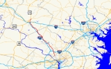
Maryland Route 355 is a 36.94 miles (59.45 km) north–south road in western central Maryland
in the United States
. The southern terminus of the route is at the Washington, D.C.
border in Friendship Heights, Montgomery County
, where it continues south as Wisconsin Avenue into Washington. The northern terminus is just north of an overpass with Interstate 70
and U.S. Route 40
in the city of Frederick
in Frederick County
, where the road continues north as Market Street. MD 355 serves as a major thoroughfare through Frederick and Montgomery counties, passing through Bethesda
, Rockville
, Gaithersburg
, Germantown, Urbana
, and Frederick, roughly parallel to Interstate 270
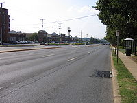
. The southern portion of the route from the D.C. border to Germantown is a suburban four- to six-lane divided highway
lined with many businesses. North of Germantown, the route is predominantly a two lane rural road until it reaches Frederick, where it passes through commercial areas in the southern part of the city.
MD 355 is the original route of U.S. Route 240
, which was planned in 1926 to run from Washington, D.C. north to Harrisburg, Pennsylvania
; however, the route was designated a part of US 15 north of Frederick. This route served as the primary connector linking Frederick and points west to Washington, D.C. In 1953, a freeway called the Washington National Pike was built for US 240 between Bethesda and Frederick, which became Interstate 70S (now I-270) with the creation of the Interstate Highway System
. Meanwhile, the portion of former US 240 north of the freeway’s southern terminus was designated MD 355 by 1960. By 1975, the US 240 designated was removed from the U.S. Highway System, and MD 355 was extended south to the D.C. border. In 2006, the interchange with US 15 at the route’s northern terminus was removed, resulting in MD 355 ending just short of US 15 at a dead end. By 2009, a four lane divided bypass of Urbana for MD 355, funded by private developers, was completed. The same year, the portion of MD 355 north of I-70 was transferred to the city of Frederick and is no longer considered part of the route.
 Maryland Route 355 begins in Friendship Heights, Montgomery County
at the intersection with Western Avenue NW and Military Road NW on the border of Washington D.C.. It heads north from this point on Wisconsin Avenue, a six-lane divided highway
with a 35 mph (56.3 km/h) speed limit. Wisconsin Avenue continues south into Washington, ending in Georgetown
at an intersection with K Street under the Whitehurst Freeway just north of the Potomac River
. From the D.C. border, MD 355 heads north through areas of retail and high-rise buildings in Friendship Heights including The Shops at Wisconsin Place
that are served by the Red Line
of the Washington Metro
. Past Friendship Heights, the route continues into wooded residential areas of Somerset
before passing the Chevy Chase Country Club on the east side of the road and residential areas of Chevy Chase
to the west. It comes to an intersection with Maryland Route 191
(Bradley Boulevard/Bradley Lane). Past this intersection, the speed limit decreases to 25 mph (40.2 km/h) and MD 355 enters Bethesda
, where it heads back into commercial areas with high-rise buildings. In downtown Bethesda, the road intersects Maryland Route 410
(Montgomery Avenue) one-way eastbound and the westbound direction of MD 410 (East West Highway) and Maryland Route 187
(Old Georgetown Road) a short distance further on, near the Bethesda Metro station
. The road continues through the community and passes by Bethesda Theatre
, a 1938 Art Deco
cinema. It leaves the downtown area of Bethesda and becomes Rockville Pike at the intersection with Glenbrook Parkway/Woodmont Avenue. From here, the speed limit increases to 35 mph (56.3 km/h) again and the road passes the Bethesda Naval Hospital, one of the United States' most prominent military hospitals, and the National Institutes of Health
, which is home to the United States National Library of Medicine
, the world’s largest medical library.
Past the naval hospital and the NIH, the road intersects Cedar Lane. After this intersection, it heads north into wooded areas, passing near residences as well as the Bethesda Meeting House, an 1850 wood-frame church. MD 355 continues north through more suburban residential areas before coming to an interchange that provides access to Interstate 495
(Capital Beltway) and the southern terminus of Interstate 270
. Past this interchange, the speed limit increases to 45 mph (72.4 km/h) and the road skirts the edge of Rock Creek Park
, passing by the Linden Oak
at the Grosvenor Lane intersection. MD 355 continues into residential areas of North Bethesda
, where the Metro Red Line briefly comes above the surface and parallels the route to the east adjacent to the Grosvenor–Strathmore Metro station before the intersection with Maryland Route 547
(Strathmore Avenue). The speed limit decreases to 40 mph (64.4 km/h) as the route heads through some residential neighborhoods before entering a commercial area with strip malls and some high-rise buildings where the White Flint Mall
, one of the D.C. metropolitan area's largest shopping malls, is located on the east side of the road. The road comes to another intersection with MD 187 (Old Georgetown Road) as well as a newly grade-separated interchange at Montrose Parkway
. The Metro Red Line draws farther east from MD 355 before it crosses into Rockville
, the county seat of Montgomery County. In Rockville, the road passes more commercial development with a railroad line paralleling the road a short distance to the east. The route intersects Maryland Route 911 (First Street)/Wootton Parkway before the speed limit decreases to 30 mph (48.3 km/h). MD 355 intersects Maryland Route 660 (Dodge Street), which is a short connector to Maryland Route 28
(Veirs Mill Road) that the route intersects a short distance later.
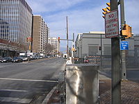
 Past this intersection, MD 355 continues into downtown Rockville, where it becomes Hungerford Drive. The road passes by the Rockville train station
, which is used by the Metro’s Red line, MARC
’s Brunswick Line
, and Amtrak
’s Capitol Limited. MD 355 heads into more commercial areas with the speed limit increasing to 35 mph (56.3 km/h). The road passes the Rockville campus of Montgomery College
before intersecting Gude Drive. Past this intersection, MD 355 becomes Frederick Road and heads northwest into a mix of commercial and residential areas as a 40 mph (64.4 km/h) road in Derwood
, drawing further away from the railroad tracks. The route leaves Rockville and intersects Shady Grove Road. Past Shady Grove Road, MD 355 interchanges with Interstate 370
and crosses into Gaithersburg
. Here, the road heads through more commercial areas before heading into residential neighborhoods. It heads into business areas again as it approaches downtown Gaithersburg, where the speed limit drops to 30 mph (48.3 km/h)before the route interchanges with Maryland Route 117
(Diamond Avenue) and continues northwest past more businesses. MD 355 passes the Lakeforest Mall
before intersecting Maryland Route 124
(Montgomery Village Avenue). MD 355 passes more strip malls past this intersection as a 40 mph (64.4 km/h) road before crossing over Great Seneca Creek and leaving Gaithersburg. The route continues northwest into Germantown through residential areas before passing businesses again and intersecting Middlebrook Road. It passes through residential developments, with the speed limit increasing to 45 mph (72.4 km/h) and the road narrowing to four lanes before it reaches an intersection with Maryland Route 118
(Germantown Road). From here, the road passes more homes and a shopping center prior to crossing Maryland Route 27
(Ridge Road).
Past MD 27, the road passes more suburban developments before narrowing to a two-lane undivided road and heading through some woodland with a speed limit of 50 mph (80.5 km/h). It continues northwest through a mix of rural woodland and suburban development in Clarksburg
, with the speed limit dropping to 40 mph (64.4 km/h) and then to 30 mph (48.3 km/h) before MD 355 intersects Maryland Route 121
(Clarksburg Road). Past this intersection, the speed limit eventually increases back to 50 mph (80.5 km/h) and the route passes Little Bennett Regional Park on the east and businesses on the west, running closely parallel to I-270 located to the west. The route eventually draws farther east of I-270 and heads through residential neighborhoods and woodland before reaching Hyattstown
, where the speed limit drops back to 30 mph (48.3 km/h). In Hyattstown, MD 355 intersects Maryland Route 109
(Old Hundred Road).
In Montgomery County, the daily traffic counts on MD 355 range from a high of 69,331 vehicles at the intersection with Bellevue Drive in Bethesda to a low of 8,021 vehicles at the intersection with Comus Road between Clarksburg and Hyattstown in 2007.
 After passing through Hyattstown, MD 355 crosses into Frederick County
, where it becomes Urbana Pike. Here, it passes some businesses before intersecting Maryland Route 75
(Green Valley Road). Past this intersection, the road continues into a more rural setting consisting of farmland, woods, and some residential areas and businesses. The speed limit increases to 50 mph (80.5 km/h) on this stretch of MD 355. The route reaches Urbana
, where it heads onto a four lane divided bypass to the east of the community, while the former alignment of MD 355 continues through Urbana as Maryland Route 355 Business. MD 355 intersects Maryland Route 80
(Fingerboard Road) and passes through residential areas in the Villages of Urbana subdivision, encountering two roundabout
s. Upon leaving Urbana, the route returns to its original alignment on a two lane undivided road and the speed limit eventually reaches 50 mph (80.5 km/h) as it continues north through areas of woods and farms with some rural residences. The road passes Monocacy National Battlefield
, the site of the Battle of Monocacy Junction in the American Civil War
fought on July 9, 1864. Past the battlefield, the road crosses the Monocacy River
and a CSX railroad line.
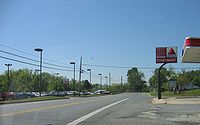
In a short distance, MD 355 heads from rural areas into a commercial district on the outskirts of Frederick
. The road widens to four lanes and the speed limit drops to 40 mph (64.4 km/h) as it passes by the Francis Scott Key Mall and several other businesses. It intersects Maryland Route 85
(Buckeystown Pike), which provides access to and from Interstate 70
and U.S. Route 40
. MD 355 passes over I-70/US 40 and ends just north of the overpass, with the road continuing north into Frederick as locally-maintained Market Street.
_approaching_madison_st_-_clarke_pl_1.jpg) The Rockville Pike portion of MD 355 dates back to colonial times and was used as an escape route from Washington during the War of 1812
The Rockville Pike portion of MD 355 dates back to colonial times and was used as an escape route from Washington during the War of 1812
as well as a route for settlers to travel from Montgomery County to developing areas north and west. In the approved plan for the U.S. Highway System in 1926, U.S. Route 240
was planned to go from Washington, D.C. to Harrisburg, Pennsylvania
, running along Wisconsin Avenue and the present-day alignment of Maryland Route 355 between Washington and Frederick, and along US 15 between Frederick and Harrisburg. By 1927, US 240 was designated along the proposed 1926 route south of Frederick with the US 15 designation given to the road north of Frederick. In 1947, plans were made to construct a freeway, the Washington National Pike (now I-270), parallel to US 240. This road was completed in 1953, and the US 240 designation was moved to it. Following the creation of the Interstate Highway System
in 1956, Interstate 70S was designated along the US 240 freeway. The bypassed portion of the original US 240, north of the current interchange between I-495 and I-270, was designated as MD 355 by 1960. The US 240 designation was removed from the U.S. Highway System by 1975, with MD 355 being extended south along the former US 240 to the Washington, D.C. border. In 2006, the northern terminus of MD 355 at an interchange with US 15 in Frederick was truncated to a dead end a short distance south of that route.
A four-lane divided bypass of Urbana was constructed for MD 355 in the 2000s. The primary reason for constructing the bypass was to relieve traffic heading through the community brought on by the construction of numerous shopping centers in the area, and the costs for constructing the bypass were entirely paid for by the developers of an area shopping center. The proposal for the bypass called for two roundabouts to control traffic. The first portion of the road, which was funded by opened in late 2005 from MD 355 south to a roundabout at Sugarloaf Parkway. On October 30, 2008, construction began to build the connection of the bypass to MD 355 south of MD 80. The realignment of MD 355 onto the bypass was completed by January 2009, with the original alignment becoming Maryland Route 355 Business. In 2009, the portion of MD 355 north of the I-70 overpass was transferred to the city of Frederick, with the MD 355 designation officially being removed from this stretch. In 2010, an interchange was completed at Montrose Parkway.
Maryland
Maryland is a U.S. state located in the Mid Atlantic region of the United States, bordering Virginia, West Virginia, and the District of Columbia to its south and west; Pennsylvania to its north; and Delaware to its east...
in the United States
United States
The United States of America is a federal constitutional republic comprising fifty states and a federal district...
. The southern terminus of the route is at the Washington, D.C.
Washington, D.C.
Washington, D.C., formally the District of Columbia and commonly referred to as Washington, "the District", or simply D.C., is the capital of the United States. On July 16, 1790, the United States Congress approved the creation of a permanent national capital as permitted by the U.S. Constitution....
border in Friendship Heights, Montgomery County
Montgomery County, Maryland
Montgomery County is a county in the U.S. state of Maryland, situated just to the north of Washington, D.C., and southwest of the city of Baltimore. It is one of the most affluent counties in the United States, and has the highest percentage of residents over 25 years of age who hold post-graduate...
, where it continues south as Wisconsin Avenue into Washington. The northern terminus is just north of an overpass with Interstate 70
Interstate 70 in Maryland
Interstate 70 is a part of the Interstate Highway System that runs from Cove Fort, Utah to Baltimore, Maryland. In Maryland, the Interstate Highway runs from the Pennsylvania state line in Hancock east to the Interstate's eastern terminus near its junction with I-695 at a park and ride in...
and U.S. Route 40
U.S. Route 40 in Maryland
U.S. Route 40 in the U.S. state of Maryland runs from western Maryland to Cecil County in the state's northeastern corner. With a total length of over , it is the longest numbered highway in Maryland. Almost half of the road overlaps with Interstate 68 or Interstate 70, while the old alignment...
in the city of Frederick
Frederick, Maryland
Frederick is a city in north-central Maryland. It is the county seat of Frederick County, the largest county by area in the state of Maryland. Frederick is an outlying community of the Washington-Arlington-Alexandria, DC-VA-MD-WV Metropolitan Statistical Area, which is part of a greater...
in Frederick County
Frederick County, Maryland
Frederick County is a county located in the western part of the U.S. state of Maryland, bordering the southern border of Pennsylvania and the northeastern border of Virginia. As of the 2010 Census, the population was 233,385....
, where the road continues north as Market Street. MD 355 serves as a major thoroughfare through Frederick and Montgomery counties, passing through Bethesda
Bethesda, Maryland
Bethesda is a census designated place in southern Montgomery County, Maryland, United States, just northwest of Washington, D.C. It takes its name from a local church, the Bethesda Meeting House , which in turn took its name from Jerusalem's Pool of Bethesda...
, Rockville
Rockville, Maryland
Rockville is the county seat of Montgomery County, Maryland, United States. It is a major incorporated city in the central part of Montgomery County and forms part of the Baltimore-Washington Metropolitan Area. The 2010 U.S...
, Gaithersburg
Gaithersburg, Maryland
Gaithersburg is a city in Montgomery County, Maryland, United States. The city had a population of 59,933 at the 2010 census, making it the fourth largest incorporated city in the state, behind Baltimore, Frederick, and Rockville...
, Germantown, Urbana
Urbana, Maryland
Urbana is an unincorporated community located in southern Frederick County, Maryland. It lies at the I-270/MD 80 interchange, about southeast of Frederick.-History:The Urbana area was first settled in 1730....
, and Frederick, roughly parallel to Interstate 270
Interstate 270 (Maryland)
Interstate 270 is a auxiliary Interstate Highway in the U.S. state of Maryland that travels between Interstate 495 just north of Bethesda, Montgomery County and Interstate 70 in the city of Frederick in Frederick County. It consists of the mainline as well as a spur that provides access to and...
. The southern portion of the route from the D.C. border to Germantown is a suburban four- to six-lane divided highway
Divided Highway
Divided Highway is a compilation album by American rock band The Doobie Brothers, released in 2003. . All tracks are taken from the albums Cycles and Brotherhood .-Track listing:...
lined with many businesses. North of Germantown, the route is predominantly a two lane rural road until it reaches Frederick, where it passes through commercial areas in the southern part of the city.
MD 355 is the original route of U.S. Route 240
U.S. Route 240
U.S. Route 240 is a defunct designation for a short, but once very important, segment of highway between Frederick, Maryland and Washington, D.C.-Route description:...
, which was planned in 1926 to run from Washington, D.C. north to Harrisburg, Pennsylvania
Harrisburg, Pennsylvania
Harrisburg is the capital of Pennsylvania. As of the 2010 census, the city had a population of 49,528, making it the ninth largest city in Pennsylvania...
; however, the route was designated a part of US 15 north of Frederick. This route served as the primary connector linking Frederick and points west to Washington, D.C. In 1953, a freeway called the Washington National Pike was built for US 240 between Bethesda and Frederick, which became Interstate 70S (now I-270) with the creation of the Interstate Highway System
Interstate Highway System
The Dwight D. Eisenhower National System of Interstate and Defense Highways, , is a network of limited-access roads including freeways, highways, and expressways forming part of the National Highway System of the United States of America...
. Meanwhile, the portion of former US 240 north of the freeway’s southern terminus was designated MD 355 by 1960. By 1975, the US 240 designated was removed from the U.S. Highway System, and MD 355 was extended south to the D.C. border. In 2006, the interchange with US 15 at the route’s northern terminus was removed, resulting in MD 355 ending just short of US 15 at a dead end. By 2009, a four lane divided bypass of Urbana for MD 355, funded by private developers, was completed. The same year, the portion of MD 355 north of I-70 was transferred to the city of Frederick and is no longer considered part of the route.
Montgomery County
Montgomery County, Maryland
Montgomery County is a county in the U.S. state of Maryland, situated just to the north of Washington, D.C., and southwest of the city of Baltimore. It is one of the most affluent counties in the United States, and has the highest percentage of residents over 25 years of age who hold post-graduate...
at the intersection with Western Avenue NW and Military Road NW on the border of Washington D.C.. It heads north from this point on Wisconsin Avenue, a six-lane divided highway
Divided Highway
Divided Highway is a compilation album by American rock band The Doobie Brothers, released in 2003. . All tracks are taken from the albums Cycles and Brotherhood .-Track listing:...
with a 35 mph (56.3 km/h) speed limit. Wisconsin Avenue continues south into Washington, ending in Georgetown
Georgetown, Washington, D.C.
Georgetown is a neighborhood located in northwest Washington, D.C., situated along the Potomac River. Founded in 1751, the port of Georgetown predated the establishment of the federal district and the City of Washington by 40 years...
at an intersection with K Street under the Whitehurst Freeway just north of the Potomac River
Potomac River
The Potomac River flows into the Chesapeake Bay, located along the mid-Atlantic coast of the United States. The river is approximately long, with a drainage area of about 14,700 square miles...
. From the D.C. border, MD 355 heads north through areas of retail and high-rise buildings in Friendship Heights including The Shops at Wisconsin Place
The Shops at Wisconsin Place
The Shops at Wisconsin Place is an open-air shopping center that is part of the mixed-use Wisconsin Place complex, located in Chevy Chase, Maryland, located on the site of a former Woodward & Lothrop department store, which was converted to Hecht's in 1995 and closed in 2005...
that are served by the Red Line
Red Line (Washington Metro)
The Red Line of the Washington Metro is a rail rapid transit service operating between 27 stations in Montgomery County, Maryland and the District of Columbia, United States. It is a primary line through downtown Washington, and the oldest and busiest line in the system...
of the Washington Metro
Washington Metro
The Washington Metro, commonly called Metro, and unofficially Metrorail, is the rapid transit system in Washington, D.C., United States, and its surrounding suburbs. It is administered by the Washington Metropolitan Area Transit Authority , which also operates Metrobus service under the Metro name...
. Past Friendship Heights, the route continues into wooded residential areas of Somerset
Somerset, Maryland
Somerset is an incorporated town within Chevy Chase in Montgomery County, Maryland, near its border with Washington, D.C.. The population was 1,124 at the 2000 census...
before passing the Chevy Chase Country Club on the east side of the road and residential areas of Chevy Chase
Chevy Chase, Maryland
Chevy Chase is the name of both a town and an unincorporated census-designated place in Montgomery County, Maryland. In addition, a number of villages in the same area of Montgomery County include "Chevy Chase" in their names...
to the west. It comes to an intersection with Maryland Route 191
Maryland Route 191
Maryland Route 191 is a state highway in the U.S. state of Maryland. The route runs from Maryland Route 190 in Potomac to Maryland Route 185 in Chevy Chase.-Route description:...
(Bradley Boulevard/Bradley Lane). Past this intersection, the speed limit decreases to 25 mph (40.2 km/h) and MD 355 enters Bethesda
Bethesda, Maryland
Bethesda is a census designated place in southern Montgomery County, Maryland, United States, just northwest of Washington, D.C. It takes its name from a local church, the Bethesda Meeting House , which in turn took its name from Jerusalem's Pool of Bethesda...
, where it heads back into commercial areas with high-rise buildings. In downtown Bethesda, the road intersects Maryland Route 410
Maryland Route 410
Maryland Route 410 is a state highway in the U.S. state of Maryland. Known for most of its length as East–West Highway, the highway runs from MD 355 in Bethesda east to Pennsy Drive in Landover Hills...
(Montgomery Avenue) one-way eastbound and the westbound direction of MD 410 (East West Highway) and Maryland Route 187
Maryland Route 187
Maryland Route 187 is a state highway in the U.S. state of Maryland. Known as Old Georgetown Road, the state highway runs from MD 355 and MD 410 in Bethesda north to MD 355 in North Bethesda...
(Old Georgetown Road) a short distance further on, near the Bethesda Metro station
Bethesda (Washington Metro)
Bethesda is an island platformed Washington Metro station in Bethesda, Maryland, United States. The station was opened on August 25, 1984, and is operated by the Washington Metropolitan Area Transit Authority . Providing service for the Red Line, the station serves downtown Bethesda and is below...
. The road continues through the community and passes by Bethesda Theatre
Bethesda Theatre
The Bethesda Theatre, constructed in 1938, is a historic Streamline Moderne movie theater located at 7719 Wisconsin Avenue , Bethesda, Maryland, United States. It is a multi-level building composed of rectangular blocks: an auditorium block and a lower street-front lobby and entrance block,...
, a 1938 Art Deco
Art Deco
Art deco , or deco, is an eclectic artistic and design style that began in Paris in the 1920s and flourished internationally throughout the 1930s, into the World War II era. The style influenced all areas of design, including architecture and interior design, industrial design, fashion and...
cinema. It leaves the downtown area of Bethesda and becomes Rockville Pike at the intersection with Glenbrook Parkway/Woodmont Avenue. From here, the speed limit increases to 35 mph (56.3 km/h) again and the road passes the Bethesda Naval Hospital, one of the United States' most prominent military hospitals, and the National Institutes of Health
National Institutes of Health
The National Institutes of Health are an agency of the United States Department of Health and Human Services and are the primary agency of the United States government responsible for biomedical and health-related research. Its science and engineering counterpart is the National Science Foundation...
, which is home to the United States National Library of Medicine
United States National Library of Medicine
The United States National Library of Medicine , operated by the United States federal government, is the world's largest medical library. Located in Bethesda, Maryland, the NLM is a division of the National Institutes of Health...
, the world’s largest medical library.
Past the naval hospital and the NIH, the road intersects Cedar Lane. After this intersection, it heads north into wooded areas, passing near residences as well as the Bethesda Meeting House, an 1850 wood-frame church. MD 355 continues north through more suburban residential areas before coming to an interchange that provides access to Interstate 495
Interstate 495 (Capital Beltway)
Interstate 495 is a Interstate Highway that surrounds the United States' capital of Washington, D.C., and its inner suburbs in adjacent Maryland and Virginia. I-495 is widely known as the Capital Beltway or simply the Beltway, especially when the context of Washington, D.C., is clear...
(Capital Beltway) and the southern terminus of Interstate 270
Interstate 270 (Maryland)
Interstate 270 is a auxiliary Interstate Highway in the U.S. state of Maryland that travels between Interstate 495 just north of Bethesda, Montgomery County and Interstate 70 in the city of Frederick in Frederick County. It consists of the mainline as well as a spur that provides access to and...
. Past this interchange, the speed limit increases to 45 mph (72.4 km/h) and the road skirts the edge of Rock Creek Park
Rock Creek Park
Rock Creek Park is a large urban natural area with public park facilities that bisects Washington, D.C. The park is administered by the National Park Service.-Rock Creek Park:The main section of the park contains , or , along the Rock Creek Valley...
, passing by the Linden Oak
Linden Oak
The Linden Oak is believed to be the largest white oak tree in the United States and is 275 years old. It received this designation after the famous Wye Oak in Wye Mills, Maryland was destroyed by a windstorm in 2002....
at the Grosvenor Lane intersection. MD 355 continues into residential areas of North Bethesda
North Bethesda, Maryland
North Bethesda is a census-designated place and an unincorporated area in Montgomery County, Maryland, United States. It borders the city of Rockville, and is closely associated with the city.-Geography:...
, where the Metro Red Line briefly comes above the surface and parallels the route to the east adjacent to the Grosvenor–Strathmore Metro station before the intersection with Maryland Route 547
Maryland Route 547
Maryland Route 547 is a state highway in the U.S. state of Maryland. The state highway runs from MD 355 in North Bethesda east to MD 185 in Kensington.-Route description:...
(Strathmore Avenue). The speed limit decreases to 40 mph (64.4 km/h) as the route heads through some residential neighborhoods before entering a commercial area with strip malls and some high-rise buildings where the White Flint Mall
White Flint Mall
White Flint Mall is an upscale shopping mall along Rockville Pike in Montgomery County, Maryland. It is known for its numerous restaurants, including P.F. Chang's China Bistro, The Cheesecake Factory, Dave & Buster's, and Bertucci's.-History:...
, one of the D.C. metropolitan area's largest shopping malls, is located on the east side of the road. The road comes to another intersection with MD 187 (Old Georgetown Road) as well as a newly grade-separated interchange at Montrose Parkway
Randolph Road
Randolph Road is a major cross-county road in Montgomery County, Maryland, and is part of a longer road that runs across Montgomery and Prince George's counties. The full road, which is also known as Montrose Road on the western end and Cherry Hill Road at the southeast, runs between the Potomac...
. The Metro Red Line draws farther east from MD 355 before it crosses into Rockville
Rockville, Maryland
Rockville is the county seat of Montgomery County, Maryland, United States. It is a major incorporated city in the central part of Montgomery County and forms part of the Baltimore-Washington Metropolitan Area. The 2010 U.S...
, the county seat of Montgomery County. In Rockville, the road passes more commercial development with a railroad line paralleling the road a short distance to the east. The route intersects Maryland Route 911 (First Street)/Wootton Parkway before the speed limit decreases to 30 mph (48.3 km/h). MD 355 intersects Maryland Route 660 (Dodge Street), which is a short connector to Maryland Route 28
Maryland Route 28
Maryland Route 28 is a state highway in the U.S. state of Maryland. The state highway runs from U.S. Route 15 in Point of Rocks east to MD 182 in Norwood. The western portion of MD 28 is a rural highway connecting several villages in southern Frederick County and western Montgomery County...
(Veirs Mill Road) that the route intersects a short distance later.
Rockville (Washington Metro)
Rockville is an island platformed Washington Metro station in Rockville, Maryland, United States. The station was opened on December 15, 1984, and is operated by the Washington Metropolitan Area Transit Authority . Providing service for the Red Line, the station is located in downtown Rockville at...
, which is used by the Metro’s Red line, MARC
MARC Train
MARC , known prior to 1984 as Maryland Rail Commuter Service, is a regional rail system comprising three lines in the Baltimore-Washington Metropolitan Area. MARC is administered by the Maryland Transit Administration , a Maryland Department of Transportation agency, and is operated under contract...
’s Brunswick Line
Brunswick Line
The Brunswick Line is a MARC commuter rail line consisting of a main line running from Washington D.C. to Martinsburg, West Virginia and a branch line from just south of Point-of-Rocks station to Frederick, Maryland. The service is operated under contract by CSX Transportation, but is administered...
, and Amtrak
Amtrak
The National Railroad Passenger Corporation, doing business as Amtrak , is a government-owned corporation that was organized on May 1, 1971, to provide intercity passenger train service in the United States. "Amtrak" is a portmanteau of the words "America" and "track". It is headquartered at Union...
’s Capitol Limited. MD 355 heads into more commercial areas with the speed limit increasing to 35 mph (56.3 km/h). The road passes the Rockville campus of Montgomery College
Montgomery College
Montgomery College is a public, open access community college located in Montgomery County, Maryland, just outside Washington, D.C. in the United States. The college has three campuses, the largest of which is in Rockville; the other campuses are in Takoma Park/Silver Spring and Germantown...
before intersecting Gude Drive. Past this intersection, MD 355 becomes Frederick Road and heads northwest into a mix of commercial and residential areas as a 40 mph (64.4 km/h) road in Derwood
Derwood, Maryland
Derwood is an unincorporated area of about 15,600 people in east-central Montgomery County, Maryland. It is a relatively dense area. It lies just east of Rockville, south east of Gaithersburg, south west of Olney, and north west of the greater Silver Spring, Maryland area. Residents of Derwood...
, drawing further away from the railroad tracks. The route leaves Rockville and intersects Shady Grove Road. Past Shady Grove Road, MD 355 interchanges with Interstate 370
Interstate 370
Interstate 370 is a Interstate Highway spur route off I-270 in Gaithersburg, Maryland to the western end of toll road MD 200 at an interchange that provides access to the park and ride lot at the Shady Grove station on the Red Line of the Washington Metro. Despite the number, I-370 does not...
and crosses into Gaithersburg
Gaithersburg, Maryland
Gaithersburg is a city in Montgomery County, Maryland, United States. The city had a population of 59,933 at the 2010 census, making it the fourth largest incorporated city in the state, behind Baltimore, Frederick, and Rockville...
. Here, the road heads through more commercial areas before heading into residential neighborhoods. It heads into business areas again as it approaches downtown Gaithersburg, where the speed limit drops to 30 mph (48.3 km/h)before the route interchanges with Maryland Route 117
Maryland Route 117
Maryland Route 117 is the one of three highways connecting the major Washington, D.C. suburbs of Gaithersburg and Germantown...
(Diamond Avenue) and continues northwest past more businesses. MD 355 passes the Lakeforest Mall
Lakeforest Mall
Lakeforest Mall is an enclosed shopping center operated by Simon Property Group that is located in Gaithersburg, Maryland, one of the northern suburbs of Washington, D.C. in Montgomery County, Maryland. Its two levels house over 160 stores, a food court, and a large children's play...
before intersecting Maryland Route 124
Maryland Route 124
Maryland Route 124 is a mixed suburban and semi-rural road that runs through several suburbs and exurbs to the north of Washington, DC in Montgomery County, Maryland. It changes names several times over its length, beginning as Quince Orchard Road near Darnestown and terminating as Woodfield Road...
(Montgomery Village Avenue). MD 355 passes more strip malls past this intersection as a 40 mph (64.4 km/h) road before crossing over Great Seneca Creek and leaving Gaithersburg. The route continues northwest into Germantown through residential areas before passing businesses again and intersecting Middlebrook Road. It passes through residential developments, with the speed limit increasing to 45 mph (72.4 km/h) and the road narrowing to four lanes before it reaches an intersection with Maryland Route 118
Maryland Route 118
Maryland Route 118 is the "main street" and major thoroughfare for the Washington, D.C. suburb of Germantown, MD. It is known over its entire length as Germantown Road, and is commonly called "one-eighteen." It is located in Montgomery County....
(Germantown Road). From here, the road passes more homes and a shopping center prior to crossing Maryland Route 27
Maryland Route 27
Maryland Route 27 is a state highway in the central part of the U.S. state of Maryland.-Route description:MD 27, also known as Ridge Road and Manchester Road , begins in Germantown at MD 355...
(Ridge Road).
Past MD 27, the road passes more suburban developments before narrowing to a two-lane undivided road and heading through some woodland with a speed limit of 50 mph (80.5 km/h). It continues northwest through a mix of rural woodland and suburban development in Clarksburg
Clarksburg, Maryland
Clarksburg is a census-designated place and an unincorporated area in Northern Montgomery County, Maryland, United States, located along the Interstate 270 technology corridor about 4 miles north of Germantown, MD. As of Census 2010 its population is 13,766....
, with the speed limit dropping to 40 mph (64.4 km/h) and then to 30 mph (48.3 km/h) before MD 355 intersects Maryland Route 121
Maryland Route 121
Maryland Route 121, also known as Clarksburg Road, is a Maryland state highway that goes from Boyds to Clarksburg in Montgomery County, through Black Hill Regional Park.-Route description:...
(Clarksburg Road). Past this intersection, the speed limit eventually increases back to 50 mph (80.5 km/h) and the route passes Little Bennett Regional Park on the east and businesses on the west, running closely parallel to I-270 located to the west. The route eventually draws farther east of I-270 and heads through residential neighborhoods and woodland before reaching Hyattstown
Hyattstown, Maryland
Hyattstown is an unincorporated community in Montgomery County, Maryland, United States. Established in 1798 and named after its founder, John Hyatt, this crossroad's town is located on Maryland Route 355 in upper Montgomery County...
, where the speed limit drops back to 30 mph (48.3 km/h). In Hyattstown, MD 355 intersects Maryland Route 109
Maryland Route 109
Maryland Route 109 is a Maryland state highway that goes from MD 107 in Poolesville, Maryland to MD 355 in Hyattstown, Maryland. The entire route is in Montgomery County.-Route description:...
(Old Hundred Road).
In Montgomery County, the daily traffic counts on MD 355 range from a high of 69,331 vehicles at the intersection with Bellevue Drive in Bethesda to a low of 8,021 vehicles at the intersection with Comus Road between Clarksburg and Hyattstown in 2007.
Frederick County
Frederick County, Maryland
Frederick County is a county located in the western part of the U.S. state of Maryland, bordering the southern border of Pennsylvania and the northeastern border of Virginia. As of the 2010 Census, the population was 233,385....
, where it becomes Urbana Pike. Here, it passes some businesses before intersecting Maryland Route 75
Maryland Route 75
Maryland Route 75 is a state highway in the U.S. state of Maryland. Known for most of its length as Green Valley Road, the state highway runs from MD 355 near Hyattstown north to MD 31 in New Windsor...
(Green Valley Road). Past this intersection, the road continues into a more rural setting consisting of farmland, woods, and some residential areas and businesses. The speed limit increases to 50 mph (80.5 km/h) on this stretch of MD 355. The route reaches Urbana
Urbana, Maryland
Urbana is an unincorporated community located in southern Frederick County, Maryland. It lies at the I-270/MD 80 interchange, about southeast of Frederick.-History:The Urbana area was first settled in 1730....
, where it heads onto a four lane divided bypass to the east of the community, while the former alignment of MD 355 continues through Urbana as Maryland Route 355 Business. MD 355 intersects Maryland Route 80
Maryland Route 80
Maryland Route 80 is a state highway in the southern part of Frederick County in the U.S. state of Maryland. Towards its eastern terminus at MD 27, the highway briefly enters Montgomery County as well.-Counties traversed:*Frederick County*Montgomery County...
(Fingerboard Road) and passes through residential areas in the Villages of Urbana subdivision, encountering two roundabout
Roundabout
A roundabout is the name for a road junction in which traffic moves in one direction around a central island. The word dates from the early 20th century. Roundabouts are common in many countries around the world...
s. Upon leaving Urbana, the route returns to its original alignment on a two lane undivided road and the speed limit eventually reaches 50 mph (80.5 km/h) as it continues north through areas of woods and farms with some rural residences. The road passes Monocacy National Battlefield
Monocacy National Battlefield
Monocacy National Battlefield is a unit of the National Park Service, the site of the Battle of Monocacy Junction in the American Civil War fought on July 9, 1864. The battlefield straddles the Monocacy River southwest of the city of Frederick, Maryland. The battle, labeled "The Battle That Saved...
, the site of the Battle of Monocacy Junction in the American Civil War
American Civil War
The American Civil War was a civil war fought in the United States of America. In response to the election of Abraham Lincoln as President of the United States, 11 southern slave states declared their secession from the United States and formed the Confederate States of America ; the other 25...
fought on July 9, 1864. Past the battlefield, the road crosses the Monocacy River
Monocacy River
The Monocacy River is a free-flowing tributary of the Potomac River, which empties into the Atlantic Ocean via the Chesapeake Bay. The river is long, with a drainage area of about...
and a CSX railroad line.
In a short distance, MD 355 heads from rural areas into a commercial district on the outskirts of Frederick
Frederick, Maryland
Frederick is a city in north-central Maryland. It is the county seat of Frederick County, the largest county by area in the state of Maryland. Frederick is an outlying community of the Washington-Arlington-Alexandria, DC-VA-MD-WV Metropolitan Statistical Area, which is part of a greater...
. The road widens to four lanes and the speed limit drops to 40 mph (64.4 km/h) as it passes by the Francis Scott Key Mall and several other businesses. It intersects Maryland Route 85
Maryland Route 85
Maryland Route 85 is a state highway in the U.S. state of Maryland. Known as Buckeystown Pike, the state highway runs from MD 28 in Tuscarora north to the Frederick city limit north of Interstate 70 , where the highway continues north as East Street. MD 85 connects Tuscarora and Buckeystown in...
(Buckeystown Pike), which provides access to and from Interstate 70
Interstate 70 in Maryland
Interstate 70 is a part of the Interstate Highway System that runs from Cove Fort, Utah to Baltimore, Maryland. In Maryland, the Interstate Highway runs from the Pennsylvania state line in Hancock east to the Interstate's eastern terminus near its junction with I-695 at a park and ride in...
and U.S. Route 40
U.S. Route 40 in Maryland
U.S. Route 40 in the U.S. state of Maryland runs from western Maryland to Cecil County in the state's northeastern corner. With a total length of over , it is the longest numbered highway in Maryland. Almost half of the road overlaps with Interstate 68 or Interstate 70, while the old alignment...
. MD 355 passes over I-70/US 40 and ends just north of the overpass, with the road continuing north into Frederick as locally-maintained Market Street.
History
War of 1812
The War of 1812 was a military conflict fought between the forces of the United States of America and those of the British Empire. The Americans declared war in 1812 for several reasons, including trade restrictions because of Britain's ongoing war with France, impressment of American merchant...
as well as a route for settlers to travel from Montgomery County to developing areas north and west. In the approved plan for the U.S. Highway System in 1926, U.S. Route 240
U.S. Route 240
U.S. Route 240 is a defunct designation for a short, but once very important, segment of highway between Frederick, Maryland and Washington, D.C.-Route description:...
was planned to go from Washington, D.C. to Harrisburg, Pennsylvania
Harrisburg, Pennsylvania
Harrisburg is the capital of Pennsylvania. As of the 2010 census, the city had a population of 49,528, making it the ninth largest city in Pennsylvania...
, running along Wisconsin Avenue and the present-day alignment of Maryland Route 355 between Washington and Frederick, and along US 15 between Frederick and Harrisburg. By 1927, US 240 was designated along the proposed 1926 route south of Frederick with the US 15 designation given to the road north of Frederick. In 1947, plans were made to construct a freeway, the Washington National Pike (now I-270), parallel to US 240. This road was completed in 1953, and the US 240 designation was moved to it. Following the creation of the Interstate Highway System
Interstate Highway System
The Dwight D. Eisenhower National System of Interstate and Defense Highways, , is a network of limited-access roads including freeways, highways, and expressways forming part of the National Highway System of the United States of America...
in 1956, Interstate 70S was designated along the US 240 freeway. The bypassed portion of the original US 240, north of the current interchange between I-495 and I-270, was designated as MD 355 by 1960. The US 240 designation was removed from the U.S. Highway System by 1975, with MD 355 being extended south along the former US 240 to the Washington, D.C. border. In 2006, the northern terminus of MD 355 at an interchange with US 15 in Frederick was truncated to a dead end a short distance south of that route.
A four-lane divided bypass of Urbana was constructed for MD 355 in the 2000s. The primary reason for constructing the bypass was to relieve traffic heading through the community brought on by the construction of numerous shopping centers in the area, and the costs for constructing the bypass were entirely paid for by the developers of an area shopping center. The proposal for the bypass called for two roundabouts to control traffic. The first portion of the road, which was funded by opened in late 2005 from MD 355 south to a roundabout at Sugarloaf Parkway. On October 30, 2008, construction began to build the connection of the bypass to MD 355 south of MD 80. The realignment of MD 355 onto the bypass was completed by January 2009, with the original alignment becoming Maryland Route 355 Business. In 2009, the portion of MD 355 north of the I-70 overpass was transferred to the city of Frederick, with the MD 355 designation officially being removed from this stretch. In 2010, an interchange was completed at Montrose Parkway.
Junction list
| County | Location | Mile |
Roads intersected | Notes |
|---|---|---|---|---|
| Montgomery Montgomery County, Maryland Montgomery County is a county in the U.S. state of Maryland, situated just to the north of Washington, D.C., and southwest of the city of Baltimore. It is one of the most affluent counties in the United States, and has the highest percentage of residents over 25 years of age who hold post-graduate... |
Friendship Heights | 0.00 | Western Avenue NW / Wisconsin Avenue south | Washington, D.C. Washington, D.C. Washington, D.C., formally the District of Columbia and commonly referred to as Washington, "the District", or simply D.C., is the capital of the United States. On July 16, 1790, the United States Congress approved the creation of a permanent national capital as permitted by the U.S. Constitution.... border |
| Bethesda Bethesda, Maryland Bethesda is a census designated place in southern Montgomery County, Maryland, United States, just northwest of Washington, D.C. It takes its name from a local church, the Bethesda Meeting House , which in turn took its name from Jerusalem's Pool of Bethesda... |
1.14 | |||
| 1.62 | Eastbound direction of MD 410 | |||
| 1.70 | Westbound direction of MD 410 | |||
| 3.96 | , Northern Virginia Northern Virginia Northern Virginia consists of several counties and independent cities in the Commonwealth of Virginia, in a widespread region generally radiating southerly and westward from Washington, D.C... |
Interchange, I-495 exit 34 | ||
| North Bethesda North Bethesda, Maryland North Bethesda is a census-designated place and an unincorporated area in Montgomery County, Maryland, United States. It borders the city of Rockville, and is closely associated with the city.-Geography:... |
5.27 | |||
| 6.36 | ||||
| Rockville Rockville, Maryland Rockville is the county seat of Montgomery County, Maryland, United States. It is a major incorporated city in the central part of Montgomery County and forms part of the Baltimore-Washington Metropolitan Area. The 2010 U.S... |
6.59 | Montrose Parkway Randolph Road Randolph Road is a major cross-county road in Montgomery County, Maryland, and is part of a longer road that runs across Montgomery and Prince George's counties. The full road, which is also known as Montrose Road on the western end and Cherry Hill Road at the southeast, runs between the Potomac... (MD 927A) |
Interchange | |
| 8.71 | ||||
| 9.05 | ||||
| 9.17 | ||||
| Gaithersburg Gaithersburg, Maryland Gaithersburg is a city in Montgomery County, Maryland, United States. The city had a population of 59,933 at the 2010 census, making it the fourth largest incorporated city in the state, behind Baltimore, Frederick, and Rockville... |
12.68 | Interchange, no exit to eastbound I-370, I-370 exit 2 | ||
| 14.38 | Interchange, access to and from northbound MD 355 provided by Fulks Corner Avenue | |||
| 15.43 | ||||
| Germantown | 18.81 | |||
| 19.70 | ||||
| Clarksburg Clarksburg, Maryland Clarksburg is a census-designated place and an unincorporated area in Northern Montgomery County, Maryland, United States, located along the Interstate 270 technology corridor about 4 miles north of Germantown, MD. As of Census 2010 its population is 13,766.... |
22.90 | |||
| Hyattstown Hyattstown, Maryland Hyattstown is an unincorporated community in Montgomery County, Maryland, United States. Established in 1798 and named after its founder, John Hyatt, this crossroad's town is located on Maryland Route 355 in upper Montgomery County... |
26.45 | , Washington Washington, D.C. Washington, D.C., formally the District of Columbia and commonly referred to as Washington, "the District", or simply D.C., is the capital of the United States. On July 16, 1790, the United States Congress approved the creation of a permanent national capital as permitted by the U.S. Constitution.... |
||
| Frederick Frederick County, Maryland Frederick County is a county located in the western part of the U.S. state of Maryland, bordering the southern border of Pennsylvania and the northeastern border of Virginia. As of the 2010 Census, the population was 233,385.... |
27.07 | |||
| Urbana Urbana, Maryland Urbana is an unincorporated community located in southern Frederick County, Maryland. It lies at the I-270/MD 80 interchange, about southeast of Frederick.-History:The Urbana area was first settled in 1730.... |
30.39 | |||
| Frederick Frederick, Maryland Frederick is a city in north-central Maryland. It is the county seat of Frederick County, the largest county by area in the state of Maryland. Frederick is an outlying community of the Washington-Arlington-Alexandria, DC-VA-MD-WV Metropolitan Statistical Area, which is part of a greater... |
36.61 | |||
| 36.94 | Market Street north – Downtown Frederick |