
Maryland Route 77
Encyclopedia
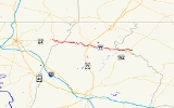
Maryland Route 77 is a state highway
in the U.S. state of Maryland
. The state highway runs 20.74 miles (33.4 km) from MD 64
in Smithsburg
east to MD 194
in Keymar
. MD 77 is the main east–west highway of northern Frederick County
. The state highway connects Thurmont
with eastern Washington County
via Foxville, which lies between South Mountain
and Catoctin Mountain
near Catoctin Mountain Park
and Cunningham Falls State Park
. MD 77 links Thurmont with western Carroll County
through the communities of Graceham
, Rocky Ridge
, and Detour
in the Monocacy River
valley. MD 77 was constructed from Thurmont east to Detour in the 1920s and early 1930s. A disjoint section of MD 77 was built between Cavetown
and Foxville in the late 1930s. The portions of the modern highway between Foxville and Thurmont and from Detour to Keymar were county highways until they were designated part of MD 77 in 1956. MD 77's western terminus was moved east to MD 64 in Smithsburg in 1960.
. MD 77's first intersection east of MD 64 is Wolfsville Road, which becomes MD 17
at the Washington–Frederick county line and heads into the Middletown Valley
. MD 77 heads east as Foxville Road, a two-lane road that passes through several sharp curves as the highway ascends South Mountain. The state highway passes Pleasant Valley Road before it reaches its highest point at the Washington–Frederick County line. East of Foxville, MD 77 begins to follows the boundary between Cunningham Falls State Park to the south and the National Park Service
-managed Catoctin Mountain Park to the north. Catoctin Mountain Park contains three historic camps: Camp Greentop
, Camp Misty Mount
, and the Presidential
retreat Camp David
.
MD 77 follows a curvaceous route along the narrow valley of Hunting Creek to descend Catoctin Mountain. The state highway emerges from the mountain valley just west of the town of Thurmont, where the highway becomes Main Street and meets U.S. Route 15
(Catoctin Mountain Highway) at a folded diamond interchange
. MD 77 intersects Church Street and Water Street in the center of town; Church Street heads north as MD 550
. The two state highways run concurrently
through the eastern part of Thurmont until MD 550 heads south as Jimtown Road and MD 77 continues east as Rocky Ridge Road. MD 77 leaves the town of Thurmont and passes through the village of Graceham, where the highway passes Graceham Moravian Church and Parsonage
and has a one-lane underpass of the Maryland Midland Railroad. The state highway passes through farmland and traverses Owens Creek just west of Old Frederick Road, which crosses the creek to the south on the Loys Station Covered Bridge
. Another historic bridge across Owens Creek, the Old Mill Road Bridge
, is accessed by Old Mill Road just east of Loyds Station.
MD 77 passes under the railroad again just west of Rocky Ridge, where the highway meets the southern end of MD 76
(Motters Station Road). The state highway crosses the Monocacy River on a through truss bridge at Millers Bridge just south of the confluence of the Monocacy River and Double Pipe Creek. A short distance to the east, MD 77 crosses Double Pipe Creek
and enters Carroll County at the village of Detour, which is located just north of the confluence of Big Pipe Creek and Little Pipe Creek to form Double Pipe Creek. The state highway continues east as Middleburg Road, which intersects the Maryland Midland Railroad at grade and crosses Big Pipe Creek before reaching its eastern terminus at MD 194 (Francis Scott Key Memorial Highway) in the village of Keymar, which sits at the junction of the Maryland Midland Railroad's east–west and north–south rail lines. Middleburg Road continues east as a county highway that passes through Middleburg
and Uniontown
before continuing as Uniontown Road toward Westminster
.
's (now MD 355
) crossing of the Baltimore & Ohio Railroad in 1930.
MD 77 was connected to US 15 in Thurmont by municipally-maintained Main Street and from Detour to MD 71 (now MD 194) in Keymar by a county connecting road. The first portion of the western half of MD 77 was built between 1936 and 1938 from Cavetown to Foxville. The westernmost part of MD 77 included Cavetown Church Road from MD 64 (now MD 66
) in Cavetown to just east of Wolfsville Road. The two sections of MD 77 were connected by county-maintained Foxville Road from Foxville to Thurmont. Foxville Road between Foxville and Thurmont and Middleburg Road from Double Pipe Creek east to MD 194 became part of MD 77 in 1956. MD 77 was widened through Thurmont that same year.
In 1956, construction began on MD 77's interchange with the US 15 bypass, which opened in 1958. The US 15 interchange originally consisted of one two-way ramp in the northeast quadrant of the junction between MD 77 and the two-lane bypass. When US 15 was expanded to a four-lane divided highway in 1985, the southbound US 15 ramps in the southwest quadrant of the junction were constructed. MD 77's western terminus was moved from Cavetown to the Smithsburg Bypass when MD 64 was moved to the new highway in 1960. The old alignment of MD 77 west to Cavetown consists of Cavetown Church Road, which is unsigned
MD 844 between MD 64 and a dead end adjacent to modern MD 77 east of Wolfsville Road.
!County
!Location
!Mile
!Destinations
!Notes
|-
|Washington
|Smithsburg
|0.00
|
|Western terminus
|-
|rowspan=4|Frederick
|rowspan=3|Thurmont
|10.10
|
|Interchange
|-
|10.47
|
|West end of concurrency with MD 550
|-
|11.46
|
|East end of concurrency with MD 550
|-
|Rocky Ridge
|15.99
|
|
|-
|Carroll
|Keymar
|20.74
|
|Eastern terminus
State highway
State highway, state road or state route can refer to one of three related concepts, two of them related to a state or provincial government in a country that is divided into states or provinces :#A...
in the U.S. state of Maryland
Maryland
Maryland is a U.S. state located in the Mid Atlantic region of the United States, bordering Virginia, West Virginia, and the District of Columbia to its south and west; Pennsylvania to its north; and Delaware to its east...
. The state highway runs 20.74 miles (33.4 km) from MD 64
Maryland Route 64
Maryland Route 64 is a state highway in the U.S. state of Maryland. The state highway runs from U.S. Route 40 in Hagerstown east to the Pennsylvania state line near Ringgold, where the highway continues as Pennsylvania Route 997...
in Smithsburg
Smithsburg, Maryland
Smithsburg is a town in Washington County, Maryland, United States. Its population was 2,146 at the 2000 census and latest 2008 estimates are at 2,908. Smithsburg is close to Fort Ritchie army base and just west of the presidential retreat Camp David....
east to MD 194
Maryland Route 194
Maryland Route 194 is a state highway in the U.S. state of Maryland. The state highway runs from MD 26 in Ceresville north to the Pennsylvania state line near Taneytown, where the highway continues as Pennsylvania Route 194 toward Hanover...
in Keymar
Keymar, Maryland
Keymar is an unincorporated community in Carroll County, Maryland, United States.-References:...
. MD 77 is the main east–west highway of northern Frederick County
Frederick County, Maryland
Frederick County is a county located in the western part of the U.S. state of Maryland, bordering the southern border of Pennsylvania and the northeastern border of Virginia. As of the 2010 Census, the population was 233,385....
. The state highway connects Thurmont
Thurmont, Maryland
Thurmont is a town in Frederick County, Maryland, United States. The population was 5,588 at the 2000 census. The town is located in the northern part of Frederick County , approximately ten miles from the Pennsylvania border, along U.S. Highway 15...
with eastern Washington County
Washington County, Maryland
Washington County is a county located in the western part of the U.S. state of Maryland, bordering southern Pennsylvania to the north, northern Virginia to the south, and the Eastern Panhandle of West Virginia to the south and west. As of the 2010 Census, its population is 147,430...
via Foxville, which lies between South Mountain
South Mountain (Maryland and Pennsylvania)
South Mountain is the northern extension of the Blue Ridge Mountain range in Maryland and Pennsylvania. From the Potomac River near Knoxville, Maryland in the south, to Dillsburg, Pennsylvania in the north, the long range separates the Hagerstown and Cumberland valleys from the Piedmont regions of...
and Catoctin Mountain
Catoctin Mountain
Catoctin Mountain, along with the geologically associated Bull Run Mountains, comprises the easternmost mountain ridge of the Blue Ridge Mountains, which are in turn a part of the Appalachian Mountains range...
near Catoctin Mountain Park
Catoctin Mountain Park
Catoctin Mountain Park, located in north-central Maryland, is part of the forested Catoctin Mountain ridge that forms the eastern rampart of the Appalachian Mountains...
and Cunningham Falls State Park
Cunningham Falls State Park
Cunningham Falls State Park is a Maryland State Park located west of Thurmont, Maryland, USA, in the Catoctin Mountains. It features a man-made lake and its namesake waterfall, Cunningham Falls. Cunningham Falls is a cascading waterfall. It is the largest waterfall in Maryland. Catoctin...
. MD 77 links Thurmont with western Carroll County
Carroll County, Maryland
Carroll County is a county located in the U.S. state of Maryland. In 2010, its population was 167,134. It was named for Charles Carroll of Carrollton , signer of the American Declaration of Independence. Its county seat is Westminster....
through the communities of Graceham
Graceham, Maryland
Graceham is an unincorporated community in Frederick County, Maryland, United States. Graceham is home to Graceham Moravian Church and Parsonage.-References:...
, Rocky Ridge
Rocky Ridge, Maryland
Rocky Ridge is an unincorporated community in Frederick County, Maryland, United States. Old Mill Road Bridge was listed on the National Register of Historic Places in 1979.-External links:*...
, and Detour
Detour, Maryland
Detour is an unincorporated community in Carroll County, Maryland, United States. William and Catherine Biggs Farm was listed on the National Register of Historic Places in 2001.-References:...
in the Monocacy River
Monocacy River
The Monocacy River is a free-flowing tributary of the Potomac River, which empties into the Atlantic Ocean via the Chesapeake Bay. The river is long, with a drainage area of about...
valley. MD 77 was constructed from Thurmont east to Detour in the 1920s and early 1930s. A disjoint section of MD 77 was built between Cavetown
Cavetown, Maryland
Cavetown is a census-designated place in Washington County, Maryland, United States. The population was 1,486 at the 2000 census.-Geography:Cavetown is located at ....
and Foxville in the late 1930s. The portions of the modern highway between Foxville and Thurmont and from Detour to Keymar were county highways until they were designated part of MD 77 in 1956. MD 77's western terminus was moved east to MD 64 in Smithsburg in 1960.
Route description
MD 77 begins at an intersection with MD 64 (Smithsburg Pike) in Smithsburg. The roadway continues northwest as county-maintained Leitersburg Smithsburg Road into the town of Smithsburg, where it becomes that town's Main Street, then continues northwest to LeitersburgLeitersburg, Maryland
Leitersburg is a census-designated place in Washington County, Maryland, United States. The population was 523 at the 2000 census.-Geography:Leitersburg is located at ....
. MD 77's first intersection east of MD 64 is Wolfsville Road, which becomes MD 17
Maryland Route 17
Maryland Route 17 is a state highway in the U.S. state of Maryland. The state highway begins at the Virginia state line at the Potomac River in Brunswick, where the highway continues south as Virginia State Route 287 . MD 17 runs north from the Brunswick Bridge to the Frederick–Washington...
at the Washington–Frederick county line and heads into the Middletown Valley
Middletown Valley
Middletown Valley, also historically known as Catoctin Valley, is a valley in western Frederick County in the state of Maryland.-Geography:...
. MD 77 heads east as Foxville Road, a two-lane road that passes through several sharp curves as the highway ascends South Mountain. The state highway passes Pleasant Valley Road before it reaches its highest point at the Washington–Frederick County line. East of Foxville, MD 77 begins to follows the boundary between Cunningham Falls State Park to the south and the National Park Service
National Park Service
The National Park Service is the U.S. federal agency that manages all national parks, many national monuments, and other conservation and historical properties with various title designations...
-managed Catoctin Mountain Park to the north. Catoctin Mountain Park contains three historic camps: Camp Greentop
Camp Greentop Historic District
Camp Greentop is located in Catoctin Mountain Park near Thurmont, Maryland. The camp was built by the Works Progress Administration labor program in the development of what was then known as the Catoctin Mountain Recreational Development Area, and comprises 22 rustic log buildings including...
, Camp Misty Mount
Camp Misty Mount Historic District
Camp Misty Mount is located in Catoctin Mountain Park near Thurmont, Maryland. The camp was built by the Works Progress Administration labor program in the development of what was then known as the Catoctin Mountain Recreational Development Area, and comprises 35 rustic log buildings including...
, and the Presidential
President of the United States
The President of the United States of America is the head of state and head of government of the United States. The president leads the executive branch of the federal government and is the commander-in-chief of the United States Armed Forces....
retreat Camp David
Camp David
Camp David is the country retreat of the President of the United States and his guests. It is located in low wooded hills about 60 mi north-northwest of Washington, D.C., on the property of Catoctin Mountain Park in unincorporated Frederick County, Maryland, near Thurmont, at an elevation of...
.
MD 77 follows a curvaceous route along the narrow valley of Hunting Creek to descend Catoctin Mountain. The state highway emerges from the mountain valley just west of the town of Thurmont, where the highway becomes Main Street and meets U.S. Route 15
U.S. Route 15 in Maryland
U.S. Route 15 is a part of the U.S. Highway System that runs from Walterboro, South Carolina to Painted Post, New York. In Maryland, the highway runs from the Virginia state line at the Potomac River in Point of Rocks north to the Pennsylvania state line near Emmitsburg. US 15 is...
(Catoctin Mountain Highway) at a folded diamond interchange
Diamond interchange
A diamond interchange is a common type of road junction, used where a freeway crosses a minor road. The freeway itself is grade-separated from the minor road, one crossing the other over a bridge...
. MD 77 intersects Church Street and Water Street in the center of town; Church Street heads north as MD 550
Maryland Route 550
Maryland Route 550 is a state highway in the U.S. state of Maryland. The state highway runs from MD 26 in Libertytown north to Pen Mar Road in Fort Ritchie...
. The two state highways run concurrently
Concurrency (road)
A concurrency, overlap, or coincidence in a road network is an instance of one physical road bearing two or more different highway, motorway, or other route numbers...
through the eastern part of Thurmont until MD 550 heads south as Jimtown Road and MD 77 continues east as Rocky Ridge Road. MD 77 leaves the town of Thurmont and passes through the village of Graceham, where the highway passes Graceham Moravian Church and Parsonage
Graceham Moravian Church and Parsonage
Graceham Moravian Church and Parsonage is a historic church building and parsonage located at 8231 Rocky Ridge Road, MD 77 in Graceham, east of Thurmont, Frederick County, Maryland. It is a two story Flemish bond brick church built in 1822, and covered with white stucco because of deteriorated...
and has a one-lane underpass of the Maryland Midland Railroad. The state highway passes through farmland and traverses Owens Creek just west of Old Frederick Road, which crosses the creek to the south on the Loys Station Covered Bridge
Loys Station Covered Bridge
The Loys Station Covered Bridge is a multiple king post wooden covered bridge near Thurmont, Maryland. The bridge was burned by an arsonist in 1991 and rebuilt using surviving framing. The original bridge spanned 90 feet in one span, but has since been modified with a pier at the middle of the...
. Another historic bridge across Owens Creek, the Old Mill Road Bridge
Old Mill Road Bridge
The Old Mill Road Bridge is a historic bridge near Rocky Ridge, Frederick County, Maryland, United States. The bridge spans Owens Creek southwest of Rocky Ridge on Old Mill Road. It is a Pratt Half-Hip through truss structure in a single span of 69 feet in length and 16 feet wide...
, is accessed by Old Mill Road just east of Loyds Station.
MD 77 passes under the railroad again just west of Rocky Ridge, where the highway meets the southern end of MD 76
Maryland Route 76
Maryland Route 76 is a state highway in the U.S. state of Maryland. Known as Motters Station Road, the state highway runs from MD 77 in Rocky Ridge north to U.S. Route 15 near Emmitsburg in northern Frederick County...
(Motters Station Road). The state highway crosses the Monocacy River on a through truss bridge at Millers Bridge just south of the confluence of the Monocacy River and Double Pipe Creek. A short distance to the east, MD 77 crosses Double Pipe Creek
Double Pipe Creek
Double Pipe Creek is a major tributary of the Monocacy River in Carroll County and Frederick County in Maryland, located several miles north and west of Westminster...
and enters Carroll County at the village of Detour, which is located just north of the confluence of Big Pipe Creek and Little Pipe Creek to form Double Pipe Creek. The state highway continues east as Middleburg Road, which intersects the Maryland Midland Railroad at grade and crosses Big Pipe Creek before reaching its eastern terminus at MD 194 (Francis Scott Key Memorial Highway) in the village of Keymar, which sits at the junction of the Maryland Midland Railroad's east–west and north–south rail lines. Middleburg Road continues east as a county highway that passes through Middleburg
Middleburg, Maryland
Middleburg is an unincorporated community in Carroll County, Maryland, United States.-References:...
and Uniontown
Uniontown, Maryland
Uniontown is an unincorporated community in Carroll County, Maryland, United States. The community is home to the Uniontown Historic District, added to the National Register of Historic Places in 1986.-References:...
before continuing as Uniontown Road toward Westminster
Westminster, Maryland
Westminster is a city in northern Maryland, United States. It is the seat of Carroll County. The city's population was 18,590 at the 2010 census. Westminster is an outlying community within the Baltimore-Towson, MD MSA, which is part of a greater Washington-Baltimore-Northern Virginia, DC-MD-VA-WV...
.
History
The first section of what was to become MD 77 was paved in concrete from the railroad crossing at Graceham east to Old Frederick Road near Loys Station by 1923. This section of improved road was extended east with concrete to Rocky Ridge starting in 1924 and completed by 1927. MD 77 was also extended west to the eastern edge of Thurmont as a macadam road by 1927. The concrete highway was extended east 1 miles (1.6 km) from Rocky Ridge in 1928 and to the Monocacy River in 1930. MD 77 was extended east to the Frederick–Carroll county line at Double Pipe Creek just west of Detour starting in 1930. The state highway's truss bridge over the Monocacy River was built in 1932, replacing an old truss bridge of the same design as one that had catastrophically failed on US 240U.S. Route 240
U.S. Route 240 is a defunct designation for a short, but once very important, segment of highway between Frederick, Maryland and Washington, D.C.-Route description:...
's (now MD 355
Maryland Route 355
Maryland Route 355 is a north–south road in western central Maryland in the United States. The southern terminus of the route is at the Washington, D.C. border in Friendship Heights, Montgomery County, where it continues south as Wisconsin Avenue into Washington. The northern terminus is...
) crossing of the Baltimore & Ohio Railroad in 1930.
MD 77 was connected to US 15 in Thurmont by municipally-maintained Main Street and from Detour to MD 71 (now MD 194) in Keymar by a county connecting road. The first portion of the western half of MD 77 was built between 1936 and 1938 from Cavetown to Foxville. The westernmost part of MD 77 included Cavetown Church Road from MD 64 (now MD 66
Maryland Route 66
Maryland Route 66 is a state highway in the U.S. state of Maryland. Known for most of its length as Mapleville Road, the state highway runs from U.S. Route 40 Alternate in Boonsboro north to MD 64 near Smithsburg...
) in Cavetown to just east of Wolfsville Road. The two sections of MD 77 were connected by county-maintained Foxville Road from Foxville to Thurmont. Foxville Road between Foxville and Thurmont and Middleburg Road from Double Pipe Creek east to MD 194 became part of MD 77 in 1956. MD 77 was widened through Thurmont that same year.
In 1956, construction began on MD 77's interchange with the US 15 bypass, which opened in 1958. The US 15 interchange originally consisted of one two-way ramp in the northeast quadrant of the junction between MD 77 and the two-lane bypass. When US 15 was expanded to a four-lane divided highway in 1985, the southbound US 15 ramps in the southwest quadrant of the junction were constructed. MD 77's western terminus was moved from Cavetown to the Smithsburg Bypass when MD 64 was moved to the new highway in 1960. The old alignment of MD 77 west to Cavetown consists of Cavetown Church Road, which is unsigned
Unsigned highway
An unsigned highway is a highway that has been assigned a route number, but does not bear conventional road markings that would normally be used to identify the route with that number...
MD 844 between MD 64 and a dead end adjacent to modern MD 77 east of Wolfsville Road.
Junction list
{| class=wikitable!County
!Location
!Mile
!Destinations
!Notes
|-
|Washington
Washington County, Maryland
Washington County is a county located in the western part of the U.S. state of Maryland, bordering southern Pennsylvania to the north, northern Virginia to the south, and the Eastern Panhandle of West Virginia to the south and west. As of the 2010 Census, its population is 147,430...
|Smithsburg
Smithsburg, Maryland
Smithsburg is a town in Washington County, Maryland, United States. Its population was 2,146 at the 2000 census and latest 2008 estimates are at 2,908. Smithsburg is close to Fort Ritchie army base and just west of the presidential retreat Camp David....
|0.00
|
|Western terminus
|-
|rowspan=4|Frederick
Frederick County, Maryland
Frederick County is a county located in the western part of the U.S. state of Maryland, bordering the southern border of Pennsylvania and the northeastern border of Virginia. As of the 2010 Census, the population was 233,385....
|rowspan=3|Thurmont
Thurmont, Maryland
Thurmont is a town in Frederick County, Maryland, United States. The population was 5,588 at the 2000 census. The town is located in the northern part of Frederick County , approximately ten miles from the Pennsylvania border, along U.S. Highway 15...
|10.10
|
|Interchange
|-
|10.47
|
|West end of concurrency with MD 550
|-
|11.46
|
|East end of concurrency with MD 550
|-
|Rocky Ridge
Rocky Ridge, Maryland
Rocky Ridge is an unincorporated community in Frederick County, Maryland, United States. Old Mill Road Bridge was listed on the National Register of Historic Places in 1979.-External links:*...
|15.99
|
|
|-
|Carroll
Carroll County, Maryland
Carroll County is a county located in the U.S. state of Maryland. In 2010, its population was 167,134. It was named for Charles Carroll of Carrollton , signer of the American Declaration of Independence. Its county seat is Westminster....
|Keymar
Keymar, Maryland
Keymar is an unincorporated community in Carroll County, Maryland, United States.-References:...
|20.74
|
|Eastern terminus